Figures & data
FIGURE 1. (a) Relationship between mean Hess altitude <h> and mean Kurowsky altitude <k> for 17 maps at 1:50,000 scale (circles) and for the measurements of CitationHess (1904; square) and CitationZverkova et al. (1982; triangle). Maps with only one h − k pair are represented by open symbols. The thin diagonal line represents equality of <h> and <k>. The parameters of the thick line fitted to the data are obtained with an algorithm of CitationPress et al. (1992; section 15.3), which takes account of uncertainty in both dependent and independent variables; see for further statistical details. (b) Relationship between mean Hess altitude <h> and glaciation level g for 17 maps at 1:50,000 scale. Details as for panel a
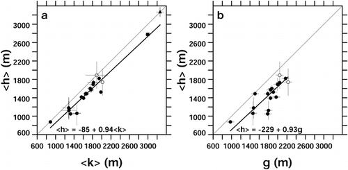
FIGURE 2. Frequency distribution of the difference of single-glacier h − k in the pooled sample from all maps. Vertical dashed line: mean difference, −155 m. The standard deviation of the sample is 182 m
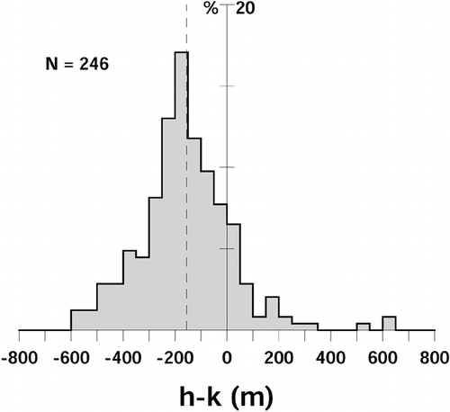
FIGURE 3. (a) Relationship between equilibrium-line altitude e and Hess altitude h for 37 glaciers. (b) Relationship between e and Kurowsky altitude k. (c) Relationship between e and glaciation level g for 15 glaciers. Regression parameters were obtained as in
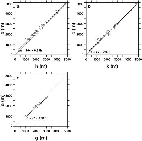
FIGURE A1. Figure 11 of CitationHess (1904), showing contour patterns in the ablation (a) and accumulation (b) areas of a typical valley glacier. Contours are solid on land and dotted on glacier ice. Hess's aim was to contrast the sharp inflections at the glacier margin in the ablation zone with the smooth transition from land to ice in the accumulation zone, but later authors have focused on the contrast in curvature on the glacier, convex in the ablation zone and concave in the accumulation zone
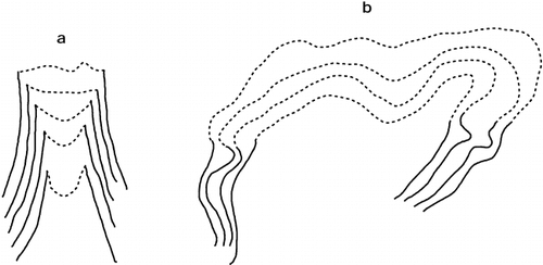
Table 1 Between-reader differencesa (Thompson Glacier region)
Table 2 Between-map differencesa (Thompson Glacier region)
Table 3 Between-map differences of differencesa (Thompson Glacier region)
Table 4 Regional variations of glacier morphology
Table 5 Summary of regional glacier morphology
Table 6 Comparison of morphological measures with measured equilibrium-line altitudes