Figures & data
FIGURE 1. Map of the Wind River Range showing the location of Sinks Canyon on the northeastern flank of the range. The locations of other localities important to the Rocky Mountain glacial succession are provided for reference
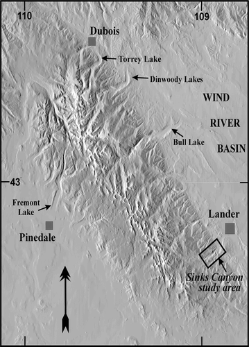
FIGURE 2. Map of Pleistocene glacial deposits in and near Sinks Canyon. Elevations of contour lines are in feet and are generalized from those on the Cony Mountain, Fossil Hill, Mt. Arter SE, Lander, and Wolf Point U.S. Geological Survey 7.5-ft topographic maps (Wyoming)
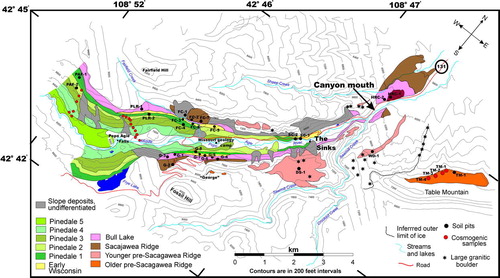
FIGURE 3. (a) View toward the southwest from the north rim of Sinks Canyon. A prominent bedrock step is at right center. The trees on the south canyon wall obscure the morphology of the Pinedale, Early Wisconsin, Bull Lake, and Sacagawea Ridge moraines. (b) View of the Pinedale, Early Wisconsin, Bull Lake, and Sacagawea Ridge moraines mapped in the southwest portion of the canyon as seen from the point labeled “George” in . (c) View from “George” toward the northeast to the mouth of the canyon. Lander is near top center. Large grassy area above the valley at upper right is part the Younger Pre–Sacagawea Ridge morphostratigraphic unit. (d) View from the north rim of Table Mountain toward the southwest showing the mouth of Sinks Canyon and two Younger Pre–Sacagawea Ridge moraine remnants mapped beyond the mouth of the canyon
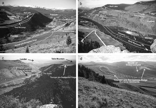
FIGURE 4. Representative morphology of granite boulders on Pleistocene deposits in Sinks Canyon. (a) Boulders on Bull Lake moraine north of PLR-2 (). Backpack indicated for scale. (b) Split and weathered boulder on the Younger Pre–Sacagawea Ridge map unit shown on the south rim of Sinks Canyon in . (c) Scatter of erratic granite boulders between Table Mountain and the Younger Pre–Sacagawea Ridge moraine remnant southwest of Table Mountain shown in . View is from the highest (southwest) end of the moraine remnant. All of the boulders that are clearly visible in the distance (such as the one indicated) are >3 m in diameter and lie directly on the dipslope of the Permian Park City Formation; they are thought to have had all surrounding till eroded from around them. (d) View of two of the granite boulders on the Older Pre–Sacagawea Ridge deposit mapped on Table Mountain () from which preliminary 10Be exposure ages were obtained. Hat and backpack for scale. These boulders yielded exposure ages of 783 kyr (TM-1) and 135 kyr (TM-2). View is from Table Mountain looking north toward Lander
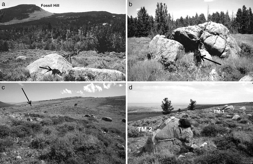
FIGURE 5. Solum thickness (A + B horizons) and depths to Cox-C horizon boundaries of soils plotted against estimated age of the glacial parent material in Sinks Canyon. Early-to-mid-Pleistocene age estimates are used for the Pre–Sacagawea Ridge deposits
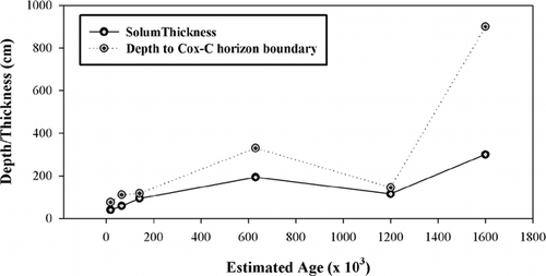
FIGURE 6. Plot of the various methods used to estimate clay accumulation in soils described in Sinks Canyon. Clay data is plotted against age of the parent material using early-to-mid-Pleistocene ages for the Pre–Sacagawea Ridge deposits
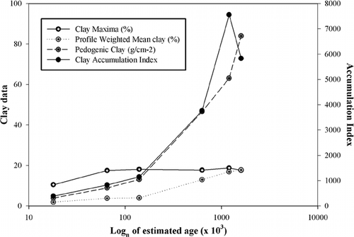
FIGURE 7. Plot of soil development indices that are most representative of the relative ages of the glacial deposits in Sinks Canyon. Index values are plotted against ages of the deposits using early-to-mid Pleistocene ages for the Pre–Sacagawea Ridge deposits
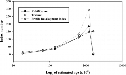
FIGURE 8. Plot of clay accumulation data for soils developed on moraines of the southwestern slope of the Wind River Range vs. ages of moraines. Note that soils on Pinedale and Early Wisconsin deposits exhibit similar values, whereas soil on Bull Lake deposits have values from ∼2–3× those of soils on the younger deposits. This phenomenon may represent the processes noted by CitationHall (1999) whereby the soil sola on older glacial deposits undergo periglacial erosion during subsequent full glacial conditions. Data taken from CitationHall (1989), CitationHall and Shroba (1993, Citation1995), and summarized in
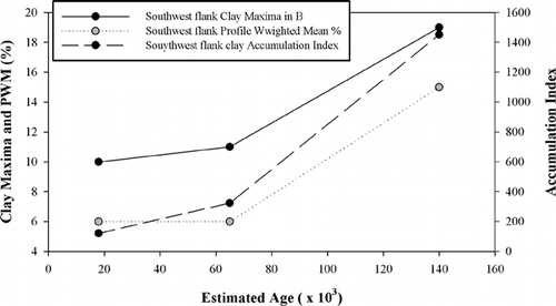
FIGURE 9. Ratios of clay accumulation and soil development index values for soils on Sinks Canyon moraines versus values for soils on moraines of the southwest slope of the Wind River Range (). Data are plotted against moraine ages. Ratios compare soil development characteristics for the two areas. Note that Sinks Canyon values are within ±0.5 of the western slope values for most characteristics when profile depth is used to weight the values. Ratios that plot outside the above range (PWM and AI) are for characteristics that are not weighted for profile depth. Early-to-mid-Pleistocene age estimates are for the parent materials of the Pre–Sacagawea Ridge soils
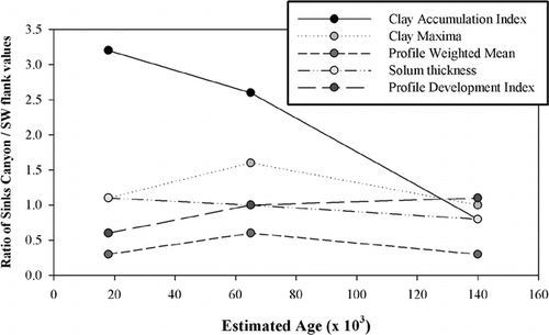
Table 1 Moraine morphology and weathering data for glacial deposits in and near Sinks Canyon, Wyoming
Table 2 Morphologic characteristics for soils in Sinks Canyon, Wyoming
Table 2 (Cont)
Table 2 (Cont)
Table 3 Laboratory data for soils in and near Sinks Canyon, Wyoming
Table 3 (Cont)
Table 3 (Cont)
Table 4 Relative development characteristics for Sinks Canyon soils
Table 5 Soil Relative Age data compiled from localities on the SW flank of the Wind River Rangea