Figures & data
FIGURE 1. Study site in the Wolf Creek Research Basin, Yukon Territory. Inset shows permafrost distribution in the Yukon (after CitationHeginbottom et al., 1995)
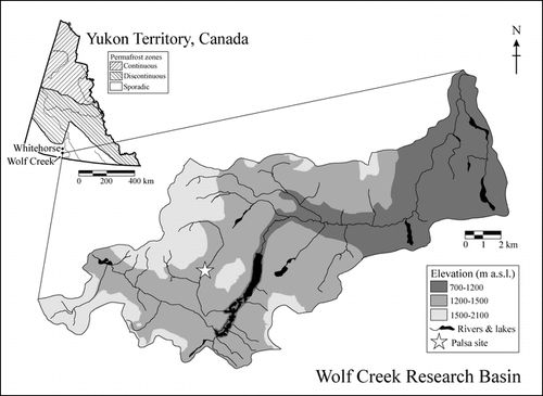
FIGURE 2. Daily shielded screen-height air temperatures (black line) and ground temperatures at 60 cm depth (gray line) on palsa 9, April 2001–August 2003. Measurements were made at hourly intervals using Onset Hobo Pro data-loggers equipped with external thermistors and averaged for each day. Note: ground temperature record ends in July 2002 when sensor cable was cut by animals
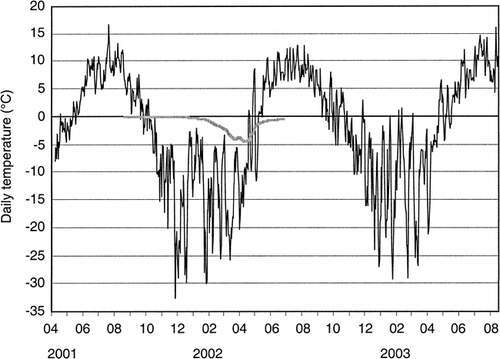
FIGURE 3. Photographs of palsas in all three stages of development. A: Aggrading palsa (20). This low, ridge-like form (outlined) is covered by grasses and sedges, with a few young shrubs and some bare peat (especially on the right-hand side). It has formed in an area that was under water in 1987. The core site is arrowed. B: Stable palsa (25). This palsa is covered by shrub birch and willow and has a minimum age of 73 yr. C: Degrading palsa (7). Shrub ring counts indicate a minimum age of 75 yr. Block collapse is taking place into the adjacent stream channel and the stratified sediments forming the palsa are exposed along a 10-m section. Note breached beaver dam in the foreground, one of ten present at the study site
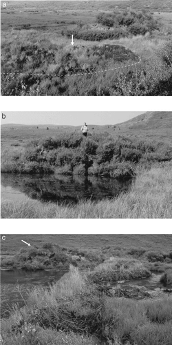
FIGURE 4. Field survey of palsas (black), surface water (light gray), and beaver dams (dark gray lines) in Wolf Creek (2001). Dams that caused ponding around the north group of mounds in 1966 and 1995 are labelled. Mound core sites are indicated by gray stars
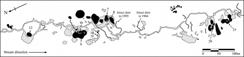
FIGURE 5. Core diagram of mound 20, showing cryostratigraphy, gravimetric moisture content, and organic content
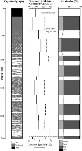
FIGURE 6. Core diagram of mound 25, showing cryostratigraphy, gravimetric moisture content, and organic content
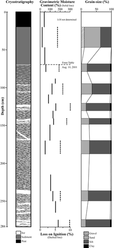
FIGURE 7. Grain-size trends in eight palsa cores. (See for mound locations)
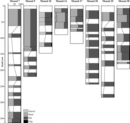
FIGURE 8. Maps of palsas and surface drainage at the main study site for different years. Palsas are shown in black and gray areas are surface water. Note: smaller mounds were not detectable using the aerial photographs. Sources: National Air Photo Library of Canada aerial photographs A10569-12 (1946), A16425-65 (1966), A27217-120 (1987), A28238-7 (1995), and A28474-207 (2001)
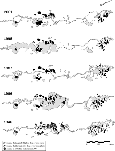
FIGURE 9. (A) Whitehorse Airport mean annual air temperature and 5-yr running mean of annual snowfall for 1943–2000 (data from Environment CitationCanada, 2002) and (B) Rates of aggradation and degradation of palsas (bar chart), and total palsa area (solid line) at Wolf Creek study site based on analysis of aerial photographs (see ). In (A), Environment Canada data for 1995–1998 are missing; best-fit lines for air temperature derived for 1943–1972 and 1972–2000. In (B), values outside bars on the lower graph are the numbers of palsas that aggraded or degraded within a given time period. Degradation is shown above the line and aggradation below the line to make comparisons with air temperature easier. Note: small palsas that are not visible on the aerial photographs are omitted from the analysis
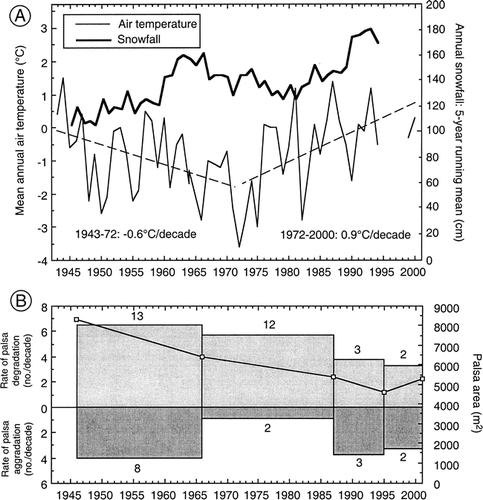
TABLE 1 Rates of degradation of palsas reported in the literature