Figures & data
FIGURE 1. (a) Location map of Expedition Fiord, Axel Heiberg Island, Nunavut. Hatched areas indicate glacial ice cover. (b) Location map of the Expedition Fiord region. The Gypsum Hill and Colour Peak springs are labeled. The red hatched markings represent surficial salt deposits; note that such deposits are associated with the springs and suggest a connection of spring activity with the subsurface evaporite diapir structures that pierce the surface at the Gypsum Hill and Colour Peak sites. Phantom and Astro Lakes are perennially ice-covered lakes that formed following the retreat of the Transit and Astro Glaciers, respectively, and may be sources of the spring water
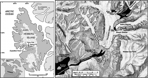
FIGURE 2. Average air temperatures for Gypsum Hill at Expedition Fiord, Axel Heiberg Island. Phases 1, 2, 3, and 4 represent different stages in the icing formation. Phase 1 occurs as air temperatures drop below the brine freezing point (−7°C) and icing of the springs' outflow begins. Phase 2 occurs when air temperatures are below the brine freezing point but above the brine eutectic point (−22.1°C) which allows for simultaneous icing melt and brine freeze. The icing completely melts during Phase 3 when temperatures rise above the brine freezing point. In Phase 4 temperatures climb above 0°C and the meltwater from the nearby White and Thompson Glaciers flows down Expedition Fiord to wash away any remaining salt and ice deposits derived from the Gypsum Hill springs
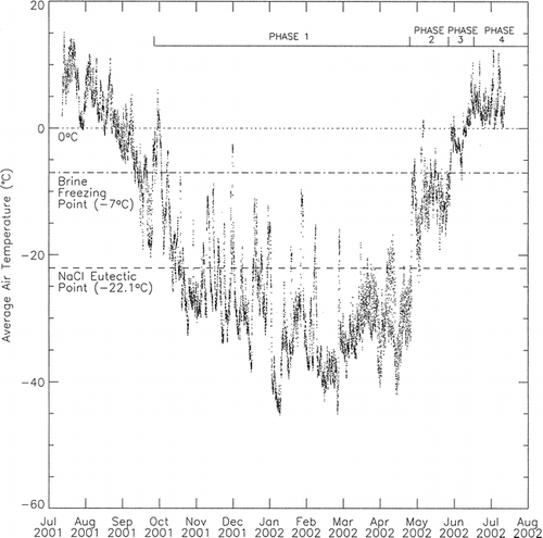
FIGURE 3. Image taken 16 July 1995 showing the relative locations of Expedition River, Gypsum Hill, Thompson Glacier, and the spring outlets. The spring outlets are located at the base of Gypsum Hill. The salt deposits within the river show the location of the wintertime icing. These remnant salt deposits are being washed away by meltwaters emanating from the Thompson Glacier which flow down the Expedition River during the summer months. Washout is typically complete by the end of June
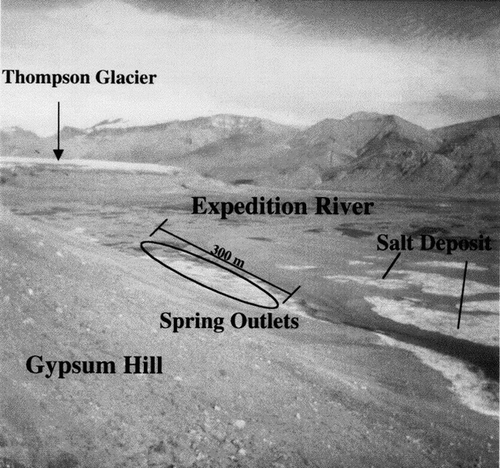
FIGURE 4. Gypsum Hill study area showing location of springs activity and icing deposit; note the size and shape of the spring icing. Airphoto A30860-139 ©1973 Her Majesty the Queen in Right of Canada, reproduced from the collection of the National Air Photo Library with permission of Natural Resources Canada
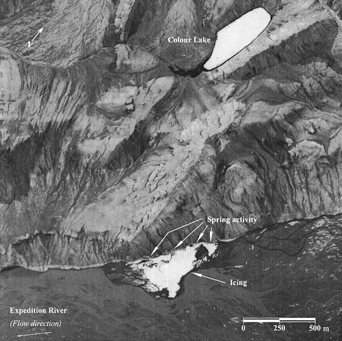
FIGURE 5. Freezing point depression curves as a function of mole fraction solute. The freezing point depression of a salt solution increases with an increased mole fraction of solute. The solid line shows the freezing curve of an ideal salt solution and the dotted line shows the freezing curve of a sodium chloride solution based on the data of CitationClark and Glew (1985)
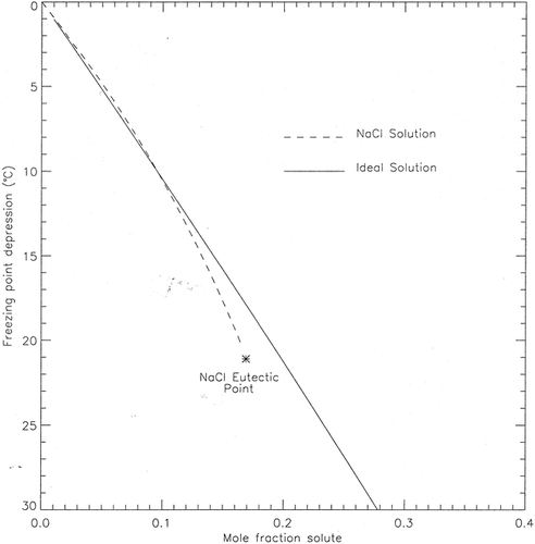
FIGURE 6. Frost blister at Gypsum Hill. Blister is approximately 1 m in height, 2 m in length, and is located within the Expedition River floodplain. The frost blister formed as discharge from the Gypsum Hill springs was injected into the soils of the Expedition River floodplain causing uplift of the frozen soil
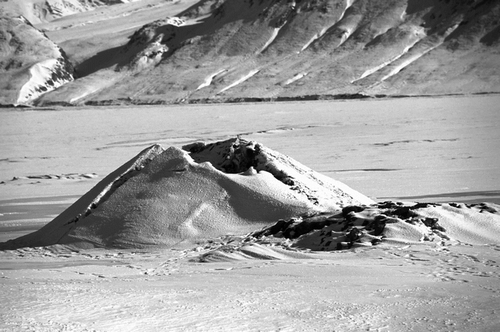
FIGURE 7. Image of the Gypsum Hill icing taken 16 April 2002 looking towards the south. As air temperatures climb above the eutectic point, the icing begins to melt and mobilize to expose underlying brine channels. Brine leaves the outlet and travels along the exposed meandering channel which is flanked on either side by an extensive icing deposit. Exposed channel at spring outlet is approximately 15 cm in width
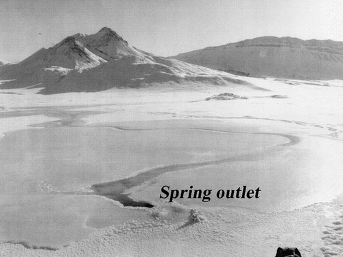
TABLE 1 Locations of data collection, sample temperatures, and sample salinities from the Gypsum Hill springs