Figures & data
FIGURE 1. Map of La Pérouse Bay, Manitoba (58°44′N, 94°28′W), showing the five regions where transects were located: (1) Beach Ridge, (2) Lagoons and Ridges, (3) Mast River Delta, (4) Southern Supratidal Marsh, and (5) Eastern Intertidal Marsh. An arrow on the inset map indicates position of La Pérouse Bay on the Hudson Bay coast, approximately 40 km east of Churchill, Manitoba
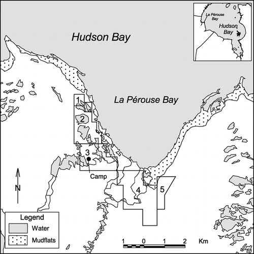
FIGURE 2. Percentage contributions of vegetation/land cover classes to the total land surface cover in 1976–1977 (white) and 1997 (black) for five different regions of coastal habitats of La Pérouse Bay, Manitoba (58°44′N, 94°28′W). Vegetation/land cover classes are: (1) Hippuris, (2) Carex aquatilis, (3) Wet graminoids, (4) Dupontia-Carex, (5) Puccinellia-Carex, (6) Mixed short grass, (7) Elymus, (8) Low willow, (9) Mixed shrubs, (10) Dry hummocks, (11) Exposed sediments. See and text for description of vegetation and land cover classes. Class 12 (water) is not shown
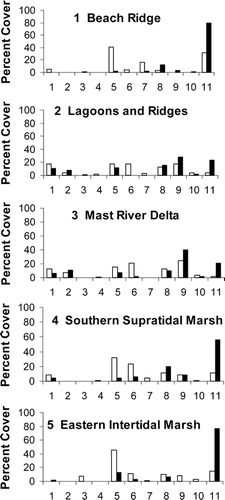
TABLE 1 Vegetation and land-cover classes used in the surveys in 1976–1977 and 1997 at La Pérouse Bay, Manitoba. Classes 12–17 inclusive were recognized only in 1997, and data from these classes were pooled with the original 12 classes (see text) in the statistical analysis
TABLE 1 (cont.)
TABLE 2 Results of log-linear modeling of cross-classified vegetation and land cover data (excluding water areas) from 1976–1977 and 1977 surveys of a snow goose colony at La Pérouse Bay, Manitoba