Figures & data
FIGURE 1. Situation of the investigated area in Europe and in the Giant Mountains; two locations are marked: Lucni Bouda chalet, where snowpack depths and duration of snow cover are regularly recorded, and Modry Dul valley, where the detailed study of the Map of the Republic took place
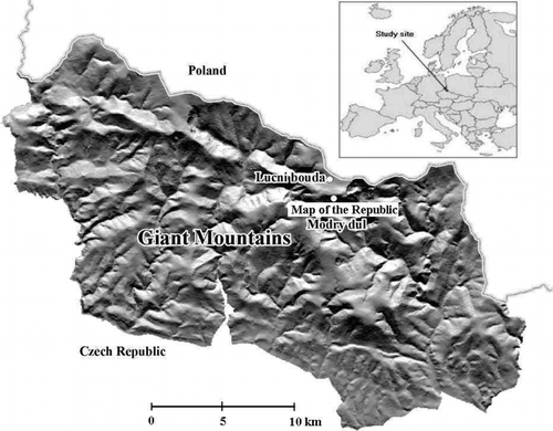
FIGURE 2. Kinematic GPS measurement by “stop and go” method on the investigated snowbed in May 2000; each point was recorded in the course of 30 sec; antenna height of the GPS receiver was 2 m
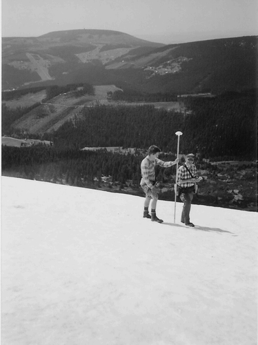
FIGURE 3. Orthophotomap of the investigated area with four zones demarcated in the nivation depression and its surrounding. (1) Zone of small depressions; white patches are Quaternary debris patches surrounded by Calluna vulgaris, Vaccinium vitis-idaea, V. myrtillus, and V. uliginosum. (2) Upper part of the nivation depression with undisturbed ground surface; the dominant plant species Nardus stricta, and patches of Molinia caerulea below Quaternary debris. (3) Main zone of active processes of nivation, with the dominant plants Avenella flexuosa, Deschampsia cespitosa, and Gnaphalium supinum. (4) Zone of solifluction lobes and slope debris, with Juncus filiformis, Viola palustris, and Deschampsia cespitosa in waterlogged soil with periodical flows. Contour interval is 5 m. The white line in the upper left hand corner is an abandoned summer footpath. Abbreviations: deb.—debris fields, on the right side of the figure Quaternary debris fields; p. m.—plants of dwarf pine (Pinus mugo)
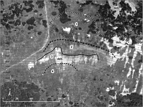
FIGURE 4. Cover degree of vascular plants (left) and melting rate in weeks from emergence of the snowbed from continuous snow cover (right) as a function of the snow depth in April 2000
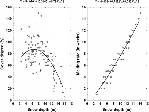
FIGURE 5. Snow cover models of the snowbed, based on snowpack depth measurement in four consecutive winter seasons in 2000, 2001, 2002, and 2003
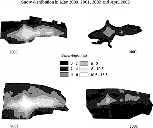
FIGURE 6. Ordination diagram showing the results of the CCA analysis (analysis no. 1 in ). Environmental variables: Soil Profile—depth of the soil profile; H—litter horizons; Soil Skeleton—share of gravel and stones in %; Above, Below—position of the relevé in relation to the central part of the snowbed; Snow Depth—snow depth in meters; Time of Melting—melting rate recorded in week intervals. Species abbreviations: anthoalp—Anthoxanthum alpinum, avenfle—Avenella flexuosa, calavil—Calamagrostis villosa, caluvul—Calluna vulgaris, carebig—Carex bigelowii, carepil—Carex pilulifera, campboh—Campanula bohemica, deschce—Deschampsia cespitosa, galisax—Galium saxatile, gentasc—Gentiana asclepiadea, gnasup—Gnaphalium supinum, hieralp—Hieracium alpinum, homoalp—Homogyne alpina, juncfil—Juncus filiformis, molicae—Molinia caerulea, nardstr—Nardus stricta, polybis—Polygonum bistorta (syn. Bistorta major), poteere—Potentilla erecta, silevul—Silene vulgaris, solialp—Solidago virgaurea subsp. alpestris, triental—Trientalis europaea, vacculig—Vaccinium uliginosum, vaccmyr—Vaccinium myrtillus, vaccviti—Vaccinium vitis-idaea, veralob—Veratrum album subsp. lobelianum, violpal—Viola palustris
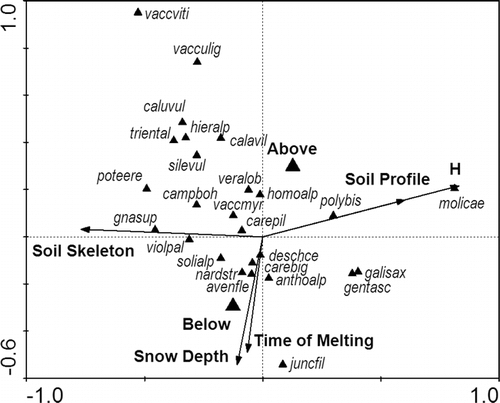
TABLE 1 Maximum snow depths, dates of snow disappearance, and differences between the date of disappearance of continuous snow cover, and dates of complete melting of the snowbed (in months)
TABLE 2 Results of CCA analyses of the cover estimates. An.—number of analyses; Expl. var.—explanatory (environmental in Canoco terminology) variables; % ax 1 (all)—species variability explained by canonical axis 1 or by all axes (measure of explanatory power of the environmental variables); F 1 (all)—F statistics for the test of the particular analysis; P 1 (all)—corresponding probability value obtained by the Monte Carlo permutation test. Abbreviations of the environmental variables: H—litter horizons, Ah—soil profile depth, S—soil skeleton in %, D—snow depth, M—melting rate in weeks from the emergence of the snow-bed from the continuous snow cover, P—position of the particular relevé (above or below the central part of the snow-bed)