Figures & data
Table 1 List of principal abbreviations used in this paper.
Figure 1 (a) Tibetan Plateau with locations of the Chinese meteorological observatories, Katmandu and Thimphu (×). (b) Naqu basin area (solid box in Fig. 1a) with locations of the CEOP-AWS (•). Numbers under the marks correspond to stations listed in . NTP = Nyeancheng Tangla Pass.
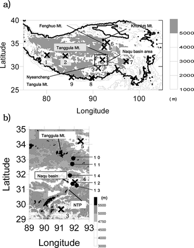
Table 2 Station list of CEOP-AWS and meteorological elements used for analysis.
Figure 2 Average hourly wind speed at 5 m during the night (3:00–5:00) and evening (15:00–17:00), shown above; and maximum and minimum air temperature at 1 m, shown below, for D105 and ANNI stations, respectively.
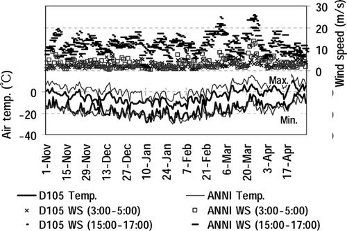
Figure 3 Downward shortwave radiation at ANNI (solid line) and D105 (dots) averaged for 8:00–10:00 (a.m.) and 13:00–15:00 (p.m.) local time.
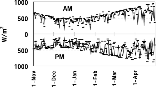
Figure 4 (a) Comparison of accumulated winter (November to April) and non-monsoon (October to May) precipitation amount and days at the stations in from 1993 to 2004 (except the data at Thimphu for 1993–1999). (b) Their year-to-year variation at Naqu CMO.
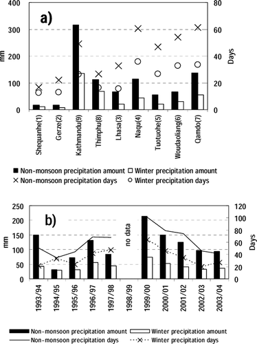
Figure 5 (a) Daily albedo, and (b) snow-depth change. Snow-depth data at BJ missing after April 24.
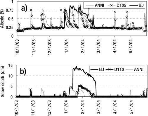
Table 3 Precipitation events from November 2003 to April 2004.
Table 4 Density and grain size of each layer at stations in .
Figure 6 Stratigraphy, and SCP/ESWQ distribution at the snow survey points during February 3–11, 2004, with locations of altitudes. The solid line (solid bars) in the bottom figure corresponds to snow cover proportion (ESWQs).
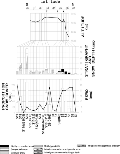
Figure 7 Snow layer observed at (a) S5 point, and (b) S6 point. S6 point is the same location as D66 CEOP-AWS site. Snow depths are 10 cm and 5 cm, respectively.
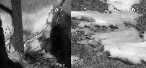
Figure 8 Surface condition at (a) S10 point and (b) south of Naqu City (near S15 point). S10 is the same location as D110 CEOP-AWS. Black spots in the lower left of (b) are yaks.
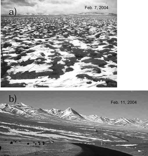
Figure 9 Comparison of temperature profiles with different surface conditions at Fenghuo Mountain pass on February 6, 2004, at 13:00 p.m. Air temperature at 1.5 m was −12.0°C with cloudy weather.
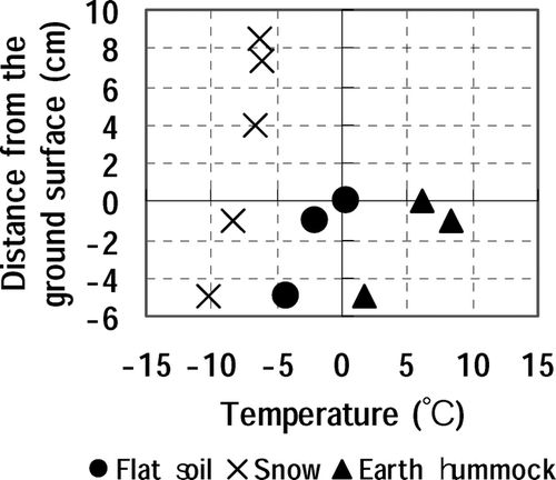
Table 5 ESWQ, Snow depth, SCP, and average density at S5, S10, S16, and S19 snow survey points, as shown in . See for explanation of abbreviations.
Figure 10 Snow cover trapped by the instruments and fence at the BJ site, in WSW direction.
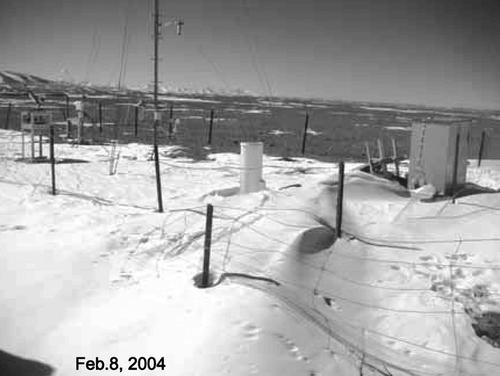
Figure 11 Relationship between albedo and snow cover percentage. Crosses indicate observation points located in the bottom of the valley with snow covered slopes.
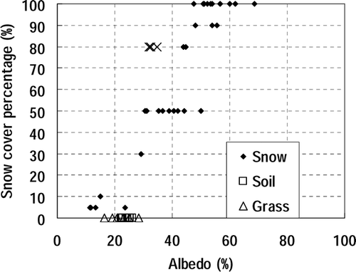
Figure 12 Time sequences of the equivalent snow water quantity at ANNI and BJ sites estimated by snow depth, albedo, and relation between albedo and snow cover percentage (). Arrows show the decreasing trends used to determine the sublimation.
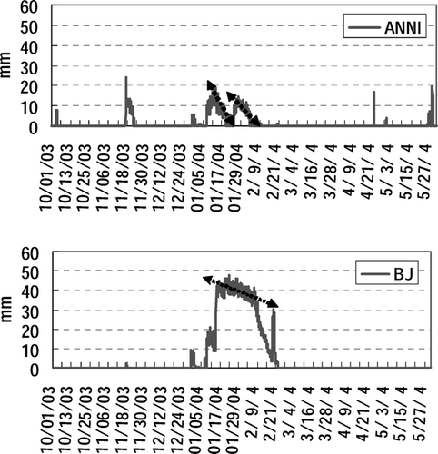
Figure 13 Daily average of surface energy fluxes at BJ site calculated by Bowen ratio methods.
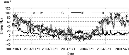
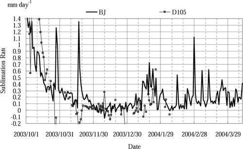
Figure 14 Daily equivalent sublimation rate estimated by latent heat flux at BJ and D105 sites.