3,202
Views
55
CrossRef citations to date
0
Altmetric
Research Articles

The Decline of Snowpatches in the Snowy Mountains of Australia: Importance of Climate Warming, Variable Snow, and Wind

&
Pages 212-218 | Accepted 01 Sep 2008, Published online: 17 Jan 2018

Figures & data

Figure 1 Map of study area showing the sites of all snowpatches in February 2004 and three additional snowpatches occurring in December 2006. Major drainage lines and the 2000 and 2100 m contours are shown. The five water bodies all exist in glacial features. Cirque boundaries are based on CitationGalloway et al. (1998) and CitationBarrows et al. (2001).
Figure 2 Snow data for Spencers Creek snow course (1830 m a.s.l.), 1954–2007. To reflect both depth and duration of snow cover, data were transformed into meter-days of snow by multiplying the depth of snow by the numbers of days at that depth and summing the weekly result to give a single figure for each year.
Figure 3 Years 1954–2007 ranked from highest to lowest in terms of meter-days of snow at Spencers Creek showing the years when snow-free season was calculated for snowpatches.

Table 1 Number of snow accumulation events (all weekly increases in snowpack of ≥10 cm at Spencers Creek) and mean ± standard deviation increase in snowpack depth. The percentage distribution of direction of winds ≥6 m sec−1 on days with precipitation in the week before snow accumulation events.

Figure 4 Regression of the last date recorded of presence of the seven late lying snowpatches on meter-days of snow at the Spencers Creek snow course (r  =  0.78, P < 0.0001). Thaw date is Julian days from January 1, hence it is positive when it occurs after January 1 and negative when it occurs in the winter in which the snow accumulated. Data for the year 1999 were not used in the regression because of lack of precision in recording the last day snowpatches were extant.
Figure 5 Decay rates for the seven studied snowpatches in 2005/2006 (dashes) and 2006/2007 (solid lines) together with 2004/2005 (dotted line) for the Cootapatamba Cornice only. The y-axis on the right is at the same scale as on the left but is raised higher to distinguish the lines for 2006/2007 for both sets of graphs. BLS  =  Blue Lake South, Twy  =  Twynam Cirque, CC  =  Cootapatamba Cornice, Club  =  Club Lake, KNE  =  Kosciuszko Northeast, Mawson  =  Mawson Cirque, and BLN  =  Blue Lake North.

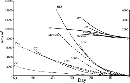
Table 2 Days required in 2006/2007 for snowpatches to decay to zero from the first measurement (square meters), together with the average maximum and minimum temperatures (°C) for that period. The dates for the equivalent starting point for 2004/2005 and 2005/2006 were calculated from equations for the decay lines in .

Table 3 Mean (± standard error) of snow-free season days beneath the center of snowpatches, in short alpine herbfield (SAH), and tall alpine herbfield (TAH) over four summers 2003/2004 to 2006/2007, together with the percentage cover of vegetation and number of plant species beneath the zones.

Reprints and Corporate Permissions

Please note: Selecting permissions does not provide access to the full text of the article, please see our help page How do I view content?

To request a reprint or corporate permissions for this article, please click on the relevant link below:

Academic Permissions

Please note: Selecting permissions does not provide access to the full text of the article, please see our help page How do I view content?

Obtain permissions instantly via Rightslink by clicking on the button below:

If you are unable to obtain permissions via Rightslink, please complete and submit this Permissions form. For more information, please visit our Permissions help page.