Figures & data
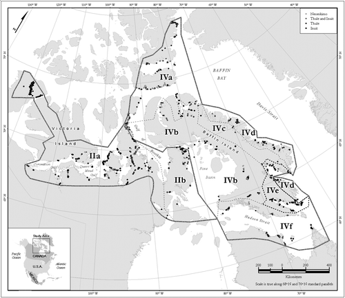
Figure 1 Map of the Canadian Arctic showing (in Roman numerals) modern climate regions and sub-regions delineated by CitationMaxwell (1980), and locations of sites discussed in the text.
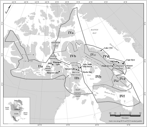
Figure 2 Summary of published high-resolution paleoclimatic data for the past millennium from adjacent climate regions east of Melville Peninsula: sea-ice extent derived from Penny Ice Cap (PIC) marine aerosol concentrations (ssNa+) redrawn from CitationGrumet et al. (2001, Fig. 2) with gray bars indicating relatively less sea ice, white bars more sea ice, based on departures from 2000-yr mean; 25-yr average PIC δ18O (CitationFisher et al., 1998); paleotemperatures (°C) derived from Donard Lake varve thicknesses (CitationMoore et al., 2001) with a vertical reference line to indicate the 2000-yr mean ( = 2.9 °C). The y-axis (YB2K) indicates years before a.d. 2000. Key to data sources: 1 = CitationGrumet et al. (2001); 2 = Fisher et al. (2003), Penny Ice Cap Ice Core Data, IGBP PAGES/World Data Center for Paleoclimatology, Data Contribution Series # 2003-093, NOAA/NGDC Paleoclimatology Program, Boulder, Colorado, U.S.A.; 3 = Moore et al. (2003), Baffin Island 1250 Year Summer Temperature Reconstruction, IGBP PAGES/World Data Center for Paleoclimatology, Data Contribution Series # 2003-075, NOAA/NGDC Paleoclimatology Program, Boulder, Colorado.
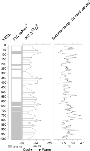
Figure 3 Summary of published high-resolution paleoclimatic data for the past millennium from adjacent climate regions west of Melville Peninsula: varve thicknesses (cumulative departures in mm) from Sanagak Lake (CitationLamoureux et al., 2006); diatom data from Lake JR01 (CitationLeBlanc et al., 2004): valve concentrations (log scale), ratio of Staurosirella pinnata to Staurosira venter diatom taxa, sample axis scores derived from ordination by DCA of diatom assemblages (0–1100 yr b.p.); pollen data from Lake JR01 (CitationZabenskie and Gajewski, 2007): pollen concentration; % Salix pollen and % pollen abundance for Arctic herbs appearing at ≥1% in any one sample (% calculated on the basis of the total count in the sample). The y-axis (YB2K) indicates years before a.d. 2000. Key to data sources: 1 = CitationLamoureux et al. (2006); 2 = CitationLeBlanc et al. (2004), data available at http://www.lpc.uottawa.ca/data; 3 = CitationZabenskie and Gajewski (2007), data available at http://www.lpc.uottawa.ca/data.
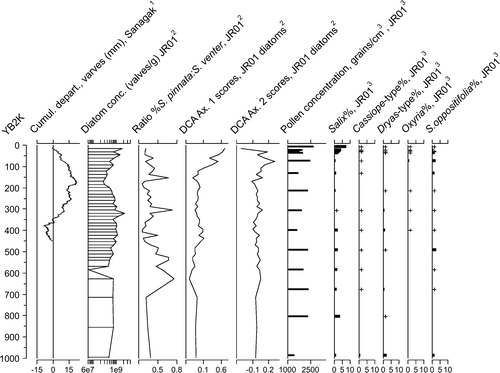
Table 1 Number of archaeological sites, and cultural designation, for sites recorded in the Canadian Museum of Civilization Site Database within Maxwell's climate Regions II and IV (CitationMaxwell, 1980). “Historic Thule Inuit” and “Ethnographic Inuit” have been grouped as “Inuit.” Data source: CitationArchaeological Survey of Canada (1972). Database accessed 2004.
Table 2 Summary of the duration of radiocarbon dates on archaeological materials at sites associated with the Neo-Eskimo culture in Climate Regions II and IV (CitationMaxwell, 1980). Source: CARD database (CitationCanadian Museum of Civilization, 2004). Bracketed numbers given beside the age ranges indicate the number of dates available to determine the duration of occupation. Dates in italics indicate that fewer than 4% of the sites in that particular climate region have been dated.
Figure 4 Distributions of archaeological sites for climate Regions II and IV associated with Neo-Eskimo, Thule/Inuit, Thule, and Inuit cultural affiliations from the Archaeological Sites Database.