Figures & data
FIGURE 1 Map of study region showing distribution of pika sites recorded in the Sierra Nevada, six southwestern Great Basin ranges, and three central Great Basin ranges, California and Nevada. Sites in Oregon are not shown. Mountain regions with pika samples include: Sierra Nevada (north, a; central, f; and southern, h); southwestern Great Basin ranges including Monitor Pass range (b), Sweetwater Mtns. (c), Wassuk Range (d), Bodie Mtns. (e), Glass Mtn. Range (g), and White/Inyo Mtns. (i); and central Great Basin ranges (j), including, from west to east, Shoshone, Toiyabe, and Toquima Ranges.
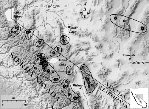
Table 1 Distribution, age, and geomorphic setting of pika occurrence and pika non-detection sites (within 30-minute search period) in the Sierra Nevada, Great Basin, and central Oregon Cascades. Rock-ice features include cirque rock glaciers, RGC; valley rock glaciers, RGV; boulder streams, BSC; solifluction slopes, MWA; see text for further description.
FIGURE 2 Slope aspects of pika occurrence and non-detection sites in the Sierra Nevada and southwestern Great Basin ranges. Azimuths were binned into eight 45° groups; arm lengths indicate the number of sites in that aspect group. Figures are scaled by sample size for each group, with center of diagram being zero. Figures A and Ci are scaled −65 to +65; Figs B, Cii, and Ciii are scaled −20 to +20. (A) All pika occurrence sites (n = 396; longest arm, NE = 65). (B) Non-detection sites (n = 92; longest arm, S = 19). (C) Sites grouped by elevation ranges: (i) pika sites >2800 m (n = 303; longest arm NE = 63), (ii) pika sites ≤2800 m (n = 93; longest arm N = 30).
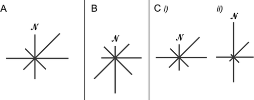
FIGURE 3 Precipitation (mm) estimated from the PRISM climate model (CitationDaly et al., 1994) and adjusted for elevation, for 343 pika sites from the Sierra Nevada and southwest Great Basin ranges. Means are given for all sites, for recently used sites (rec; including current plus modern), and for old sites. The last are indicated by dark shading. (A) Average annual precipitation. (B) Average January precipitation. (C) Average July precipitation. Dark shading indicates the 13 old sites and no shading indicates the 330 current sites. Box plots show overall mean (horizontal center of diamond), 95% confidence interval of the mean (upper and lower points of diamond), 25% and 75% quartiles (box boundaries), 50% density of values (bracket), and range of data (dotted line).
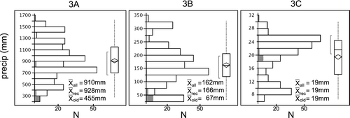
Table 2 Summary of climatic data from PRISM climate model (CitationDaly et al., 1994). Sierra Nevada vs. southwestern Great Basin pika sites. Significance differences: *** p < 0.001; * p < 0.05; ns, non significant.
FIGURE 4 Minimum temperatures (°C) estimated from the PRISM climate model (CitationDaly et al., 1994) and adjusted for elevation, for 343 pika sites from the Sierra Nevada and southwest Great Basin ranges. Means are given for all sites, for recently used sites (rec; including current plus modern), and for old sites. The last are indicated by dark shading. (A) Average minimum temperature. (B) Average January minimum temperature. (C) Average July minimum temperature. Shading for 13 old and 330 recent sites, and box plot format as in .
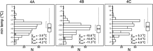
FIGURE 5 Maximum temperatures (°C) estimated from the PRISM climate model (CitationDaly et al., 1994) and adjusted for elevation, for 343 pika sites from the Sierra Nevada and southwest Great Basin ranges. Means are given for all sites, for recently used sites (rec; including current plus modern), and for old sites. The last are indicated by dark shading. (A) Average maximum temperature. (B) Average January maximum temperature. (C) Average July maximum temperature. Shading for 13 old and 330 recent sites, and box plot format as in .
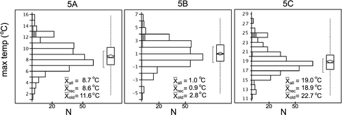
FIGURE 6 Scatterplot of correlations between elevation and precipitation for 339 pika sites from the Sierra Nevada and southwest Great Basin ranges . All pika sites combined. (A) Average annual precipitation. (B) Average January precipitation. (C) Average July precipitation. Correlation values (r) are given for each graph. Ellipsoids indicate 95% concentration of values.
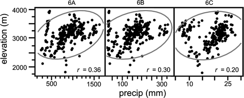
FIGURE 7 Scatterplot of correlations between elevation and temperature for 339 pika sites from the Sierra Nevada and southwest Great Basin ranges. All pika sites combined. (A) Average annual minimum temperature. (B) Average January minimum temperature. (C) Average July minimum temperature. (D). Average annual maximum temperature. (E) Average January maximum temperature. (F) Average July maximum temperature. Correlation values (r) are given for each graph. Ellipsoids indicate 95% concentration of values.
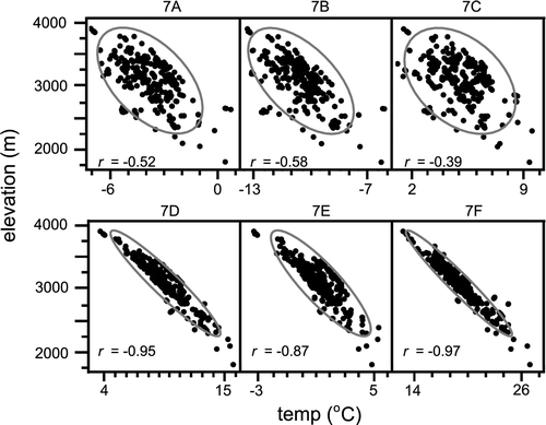
Table 3 Summary of observed air temperatures from 13 mini-dataloggers (iButtons). (A) Sensors placed on sheltered surface of rock-ice features (RIF). (B) Sensors placed in rock matrices (more than 1 m below the RIF surface) in the Sierra Nevada. Temperatures are summarized for 15 June to 15 September; years were 2006–2008. RIF types: cirque rock glacier (RGC) and scree boulder streams (BSC) (CitationMillar and Westfall, 2008).
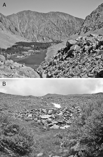
FIGURE 8 Rock glaciers and related rock-ice features in the Sierra Nevada are typically situated in cold locations, including northward-facing cirques and valleys, and in topographic locations that favor cold-air drainage. Embedded ice and high groundwater tables provide sources for persistent water even during the dry season, which support wetlands at their bases. Together the rock features and their adjacent wetland vegetation associations create optimum pika habitat. (A) Wetlands and lake at the base of rock glaciers in Lake Canyon, Mono Basin. (B) Willow-sedge association at the base of boulder streams in the upper Tuolumne River drainage, Yosemite National Park.