Figures & data
FIGURE 1 Spatial distribution of the National Weather Service and SNOTEL stations. Most of the observation stations are from these 12 counties: Archuleta, Conejos, Dolores, Hinsdale, La Plata, Mineral, Montezuma, Ouray, Rio Grande, Saguache, San Miguel, and San Juan. The NWS stations are grouped into the South West (SW), Central Mountains (CM), South Central (SC), and East (E) regions as shown by the enclosed curves.
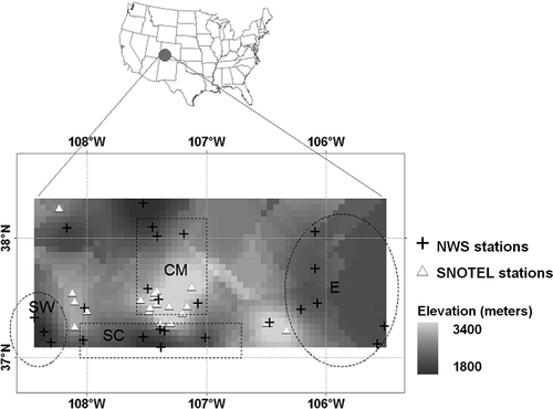
FIGURE 2 Comparison of seasonal temperature anomalies (°C) between NWS (7 stations) and SNOTEL (13 stations) stations which are located within 37–37.5°N and 107–107.5°W. “r” gives the correlation coefficient value.
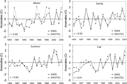
FIGURE 3 Anomalies in mean annual surface air temperature (°C) in the San Juan Mountains region between 1895 and 2005 relative to the 1960–1990 period. The light and bold curves show five-year moving average trends in temperature at the NWS and SNOTEL sites, respectively. The dashed curve shows the number of NWS stations. The number of SNOTEL stations stays constant between 1984 and 2005. The error bars describe the mean standard deviation (2 σ) in NWS temperatures for the 1895–1949 (left) and 1950–2005 (right) periods. “r” describes the correlation between the NWS and SNOTEL temperatures between 1984 and 2005.
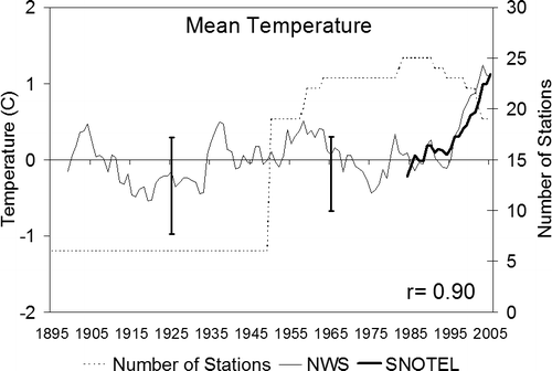
FIGURE 4 Same as but for the annual (a) maximum and (b) minimum temperature.
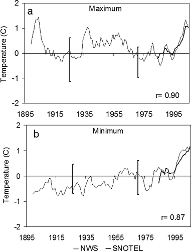
FIGURE 5 Same as but for Tmean during each season.
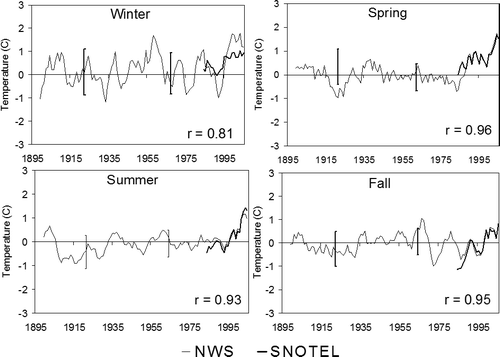
FIGURE 6 Seasonal trends in the Tmin (light curve) and Tmax (dark curve) temperatures (°C) between 1895 and 2005 at the NWS stations in the SJM region. All curves are five-year running means. The “r” values show correlation between the two curves.
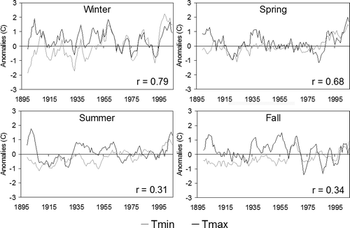
FIGURE 7 Anomalies of Tmin (light curve) and Tmax (dark curve) temperatures (°C) in the four regions identified in between 1950 and 2005. All curves are five-year running means. The “r” values show correlation between the two curves.
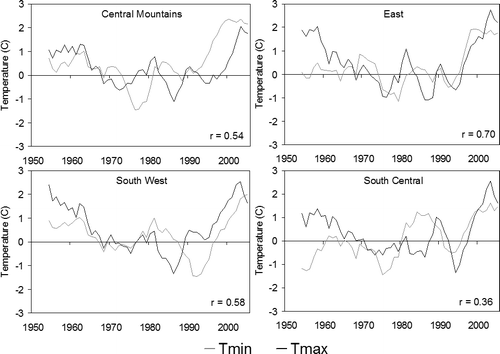
Table 1 Trends (°C/decade) in Tmean, Tmax, and Tmin calculated using Thiel-Sen non-parametric slope estimator for the 1931–2005 (75 years), 1956–2005 (50 years), 1976–2005 (30 years), and 1990–2005 periods for the SJM region. Superscript letters denote the significance level estimated from the Mann-Kendall test (N: not significant; A: p < 0.001; B: p < 0.01; C: p < 0.05).
FIGURE 8 Linear regression in annual (mean, maximum, and minimum) and seasonal (winter, spring, summer, and fall) surface air temperatures (°C/decade) during the 1990–2005 period in the San Juan Mountain region from both the NWS and SNOTEL observations. Error bars show one standard deviation.
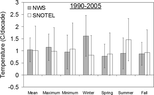
Table 2 Comparison of temperature trends from linear regression between NWS and SNOTEL sites for the 1990–2005 period. Annually and for each season, the table describes which of these two sites has a statistically greater trend in the mean, maximum, and minimum temperature. Statistical significance is measured based on 1-tailed t-test (N: not significant; A: p < 0.001; B: p < 0.01; C: p < 0.05).
FIGURE 9 Linear regression for each month in daily mean, maximum and minimum temperatures (°C/decade) during the 1990–2005 period in the San Juan Mountains region from both the NWS and SNOTEL observations. Error bars show the standard deviations.
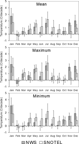
FIGURE 10 (a) Comparison of SJM (all NWS stations) and lower 48 United States' surface air temperature anomalies (°C). Curves are five-year running means. U.S. temperature anomalies are obtained from National Climatic Data Center (NCDC). (b) Temperature trends (°C/decade) for different geographic regions compared to the SJM region for the 1990–2005 period. Trends in regions other than SJM are estimated using the 5° × 5° gridded Global Historical Climatology Network land surface data set provided by NCDC.
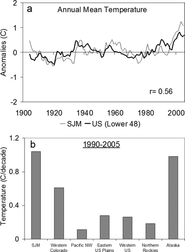
Table A1 NWS stations included for temperature observations. All stations were considered in calculating the trends.
Table A2 SNOTEL stations included for temperature observations.
FIGURE A1 Comparison of time series of annual temperature anomalies using all 25 NWS stations with that using the 16 stations that have a continuous record for the 1950–2005 period.
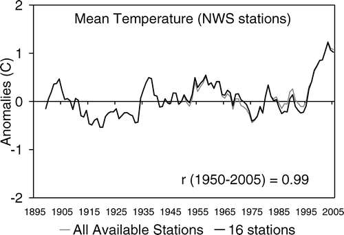
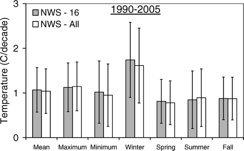
FIGURE A2 Comparison of linear regression of temperature anomalies using all 25 NWS stations with that using the 16 stations that have a continuous record for the 1950–2005 period.