Figures & data
FIGURE 1 Location of Colorado and southern Wyoming snowpack sampling sites. Dust layer solute concentration at sites within the circle exceeded those sampled at sites located farther north or south. Black triangles denote sites sampled at the Fraser Experimental Forest.
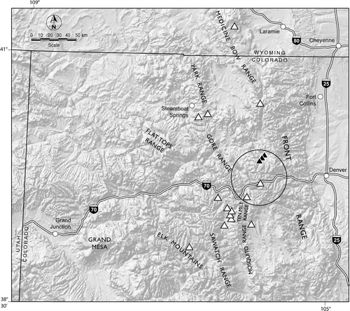
FIGURE 2 Weekly snow chemistry sampled with an Aerochem wetfall collector at the Fraser Experimental Forest (3230 m elevation), Colorado, during winter 2006. Sample points within the shaded area were collected the week of the 14–15 February dust event.
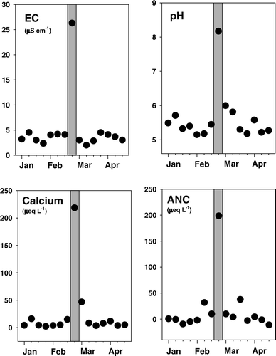
FIGURE 3 The proportional contribution of major anion and cation constituents to wetfall snow, snowpack layers, and streamwater at the Fraser Experimental Forest, Colorado. Symbol locations are plotted in a clockwise direction, as indicated by the arrows and values for each axis sum to 100.
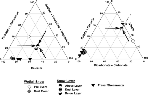
FIGURE 4 (a) Mean monthly Ca2+ deposition at 3230 m at the Fraser Experimental Forest, Colorado (2001 through 2005), compared to Ca2+ deposition during the February 2006 dust event. Shaded and open bars correspond to summer and winter season means and SE. The black bar corresponds to the Ca2+ deposition during February 2006. (b) Mean monthly deposition of sum of acids (SO4 2− + NO3 − + Cl−) at 3230 m at the Fraser Experimental Forest, Colorado (2001 through 2005), compared to the deposition of bicarbonate/carbonate-ANC during the February 2006 dust event. Shaded and open bars correspond to summer and winter season means and SE. The black bar corresponds to the bicarbonate/carbonate-ANC deposition during February 2006. ANC—acid neutralizing capacity.
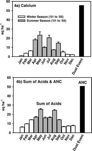
Table 1 Chemical composition of snow layers sampled at 17 sites across the Colorado and southern Wyoming Rocky Mountains. Constituent concentrations (µeq L−1, excepted where noted) were analyzed for the dust layer and samples collected >20 cm above and below the layer. EC—electrical conductivity, ANC—acid neutralizing capacity.
FIGURE 5 Monthly snowpack chemistry at the Fraser Experimental Forest from 1990 to 2005 and following the February 2006 dust event. Box plots show 15-year median snow core value, 25th/75th percentiles (box), 10th/90th percentiles (bars), and outliers (filled circles). Stars denote monthly composite snow cores collected during 2006.
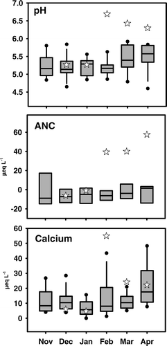
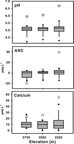
FIGURE 6 The influence of elevation on long-term (1990–2005) and dust-event February snowpack chemistry at the Fraser Experimental Forest. Box plots show 15-year median snow cores, 25th/75th percentiles (box), 10th/90th percentiles (bars), and outliers (filled circles). Stars denote February 2006 composite snow cores.