Figures & data
FIGURE 1 Overview of study area. Figures (a) and (b) locate Yellowstone National Park (YNP) and the study area. Figure (c) shows the topography of Mount Washburn. The extent of alpine vegetation is based on the vegetation classification of YNP by CitationDespain (1990). Figure (d) shows the sampled sites (sites 1–4) on the four major Mount Washburn summits, vegetation plots, and soil sensors locations. A fire lookout is built on the main (highest) Washburn summit within site 1, which adjoins the summit weather station. Note the presence of supplementary soil sensors.
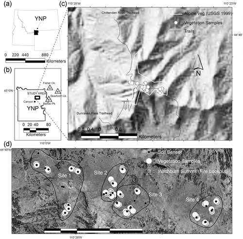
FIGURE 2 NMDS ordination and results of NP-MANOVA analyses. (a) Communities indicated with spider diagrams. Ellipses indicate 95% confidence intervals around cluster centroids. Community 1 = Elymus scribneri talus (ELSC), community 2 = Senecio canus–Astragalus kentrophyta (SECA-ASKE), community 3 = Erigeron rydbergii–Oxytropis lagopus (ERRY-OXLA), community 4 = Carex elynoides–Astragalus alpina (CAEL-ASAL), community 5 = Carex paysonis–Artemisia scopulorum (CAPA-ARSC), community 6 = Arnica rydbergii (ARRY). (b) Environmental vectors are scaled by their partial r 2's (). The direction of the arrows indicates the direction of most rapid increase for variables in the ordination. Environmental variables are: P = phosphorus (mg kg−1), C = % soil carbon, N = % soil nitrogen, Elevation = elevation (m), Slope = slope(degrees), Aspect = degrees from north, Soil = % cover of surface soil, EC = soil conductivity (mmhos cm−1), sand = % sand content of soil, silt = % silt content of soil, Temperature = soil temperature (number of summer days > 10 °C), H2O = length of water stress–free season (number of summer days > −0.12 Mpa). Note that while they have different overlays, the ordinations shown in (a) and (b) are identical. Final stress for 2D NMDS solution = 12.9.
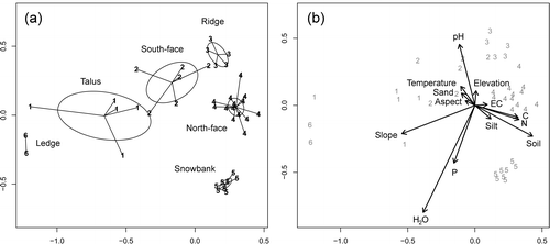
TABLE 1 Association of the NMDS ordination solution and environmental variables (see ).
TABLE 2 Summary relevé table for the six nodal community typesa. The two-character cipherb included in each cell indicates constancy (% of sites within the community that contain the species), and cover. Bolded cells indicate constancy ≥ 30%.
TABLE 3 Comparison of environments of the six nodal communitiesa on Mount Washburn. Standard errors are included with sample means.
FIGURE A1 Climate diagrams (cf. CitationWalter and Leith, 1967) for (a) Canyon Village and (b) Parker Peak SNOTEL stations (see for locations). Raw climate data provided by the CitationWestern Regional Climate Center (WRCC, 2008). The upper line shows average monthly precipitation; the lower humped line shows average mean monthly temperature. The vertically hatched area between them indicates the months that precipitation exceeds evaporation. Text at the figure top gives the following: length of records in years for temperature and precipitation, respectively [in brackets], latitude/longitude, station name, elevation, average yearly precipitation, and overall mean temperature. Average daily maximum temperature of the warmest month and average daily minimum temperature of the coldest month are indicated on the temperature axis. The white area in the strip across the bottom of the figure indicates the frost-free period.
![FIGURE A1 Climate diagrams (cf. CitationWalter and Leith, 1967) for (a) Canyon Village and (b) Parker Peak SNOTEL stations (see Fig. 1 for locations). Raw climate data provided by the CitationWestern Regional Climate Center (WRCC, 2008). The upper line shows average monthly precipitation; the lower humped line shows average mean monthly temperature. The vertically hatched area between them indicates the months that precipitation exceeds evaporation. Text at the figure top gives the following: length of records in years for temperature and precipitation, respectively [in brackets], latitude/longitude, station name, elevation, average yearly precipitation, and overall mean temperature. Average daily maximum temperature of the warmest month and average daily minimum temperature of the coldest month are indicated on the temperature axis. The white area in the strip across the bottom of the figure indicates the frost-free period.](/cms/asset/2e858365-31a9-4e5f-b478-633130abaf70/uaar_a_11957457_f0006.gif)
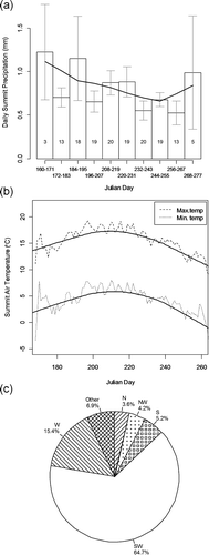
FIGURE A2 Growing season weather data from the Washburn summit. (a) Mean summer precipitation (1965–1969, 1990–2008). Numbers within the bars are the number of years of data used to compute the means. Error bars are standard errors. (b) Mean minimum and maximum temperature (1965–1969, 1990–2008). (c) Wind direction for 1965–1969, 1990–1997, and 2001–2008 (N = north, S = south, W = west). Localized weighted scatterplot smoother (lowess) lines are superimposed in (a) and (b). Raw data provided by the National Park Service.