Figures & data
Figure 1 Kasatochi Island lies on the north edge of the Aleutian Ridge, the summit of which lies within the dashed lines. Water depths on the ridge summit are typically less than 200 m. Triangles are volcanoes of Quaternary age; older rocks form much of the island area to the south. Approximate extent of tephra fallout from the 2008 Kasatochi eruption is stippled; extent south into the Pacific Ocean is poorly known. Isobaths in meters.
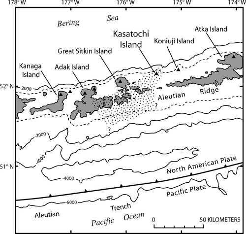
Table 1 Changes in area of Kasatochi Island, crater, and crater lake as measured from QuickBird satellite images obtained on date given in column 1. —, no data.
Figure 2 Pre-2008 reconnaissance geologic map of Kasatochi Island on QuickBird image acquired in April 2004; wispy clouds partly cover north flank. Map units: vc, volcaniclastic rocks and subordinate lava flows and dikes of southwest cliffs, late(?) Pleistocene age; lf, lava flows chiefly younger than map unit vc, probably of latest Pleistocene or Holocene age, except for lava flow that underlies map unit vc at south end of island; pf, chiefly pyroclastic-flow deposits that overlie map unit lf and vc (some may be as young as a few centuries). Informal geographic names are those coined by USFWS. Tundering and Troll taluses were major auklet rookeries; Sea lion spit was sea lion rookery. In 2005, area of lake enclosed by white dashed line was reported by observers to have been subject to intermittent surface disturbances (see text).
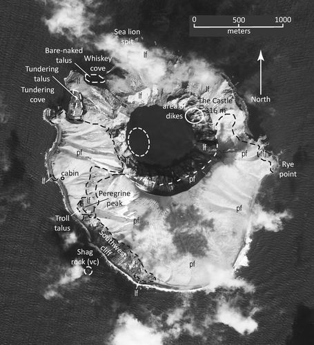
Figure 3 Pre- and post-eruption photographs of Kasatochi Island taken from a ship off the northwest coast in summer 2008. Direction of view is slightly different with the lower photograph more southerly. White stars in upper panel show locations of major sea-bird nesting sites. Tundering talus, left, is clearly visible; Troll talus, right, is not visible but lies below cliff marked by star. Note the extensive fans deposited beyond the pre-eruption sea cliff and the lowering of the west crater rim by outward erosion. The sea lion rookery on the lava-flow headland at the left edge of upper photograph is partly buried by deposits that were removed by erosion during the winter of 2008–2009. USFWS photographs by R. M. Buchheit.
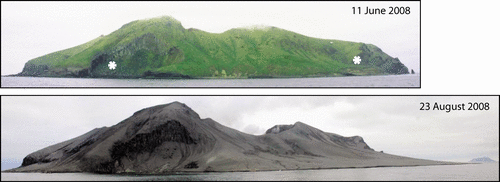
Figure 4 Generalized post-eruption geologic map on QuickBird image of 18 April 2009. Image does not register well with ; note exaggerated steepness of east crater wall. Pronounced extension of crater rim about 300 m westward suggests that main eruptive vent was at western end of pre-eruption crater. Note buried taluses and former USFWS cabin site. Map units: n, chiefly bare rock of crater walls, former sea cliffs, and steep slopes of north flank; pdn, areas of thin (typically less than a few meters thick; locally >10 m) 2008 eruptive deposits; pdk, thick (up to ~20 m) of 2008 eruptive deposits chiefly in fans outboard of former sea cliffs; a, post-eruption deposits of alluvium and debris-flow sediments from erosion of 2008 and older deposits; b, beach deposits. Note that contacts are not shown between beach and alluvial deposits, or between beach and other units where a distinct sea cliff is evident on image.
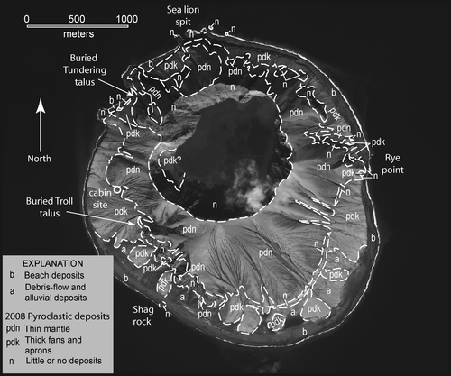
Figure 5 Black-and-white photograph of unit 1 (includes both portions m and pm) exposed on lava-flow headland on the south side of Tundering cove () shows muddy gray tephra (m) grading upward to interbedded mud and pumiceous ash (pm; around and just above 28-cm-long trowel). Unit 1 is overlain by stony lag deposits of pyroclastic flows of units 2 and 3. Unit 1 deposit lies in crevice in lava flow (lf); lava surface slopes toward viewer (U.S. Geological Survey [USGS] photograph by W. E. Scott).
![Figure 5 Black-and-white photograph of unit 1 (includes both portions m and pm) exposed on lava-flow headland on the south side of Tundering cove (Fig. 4) shows muddy gray tephra (m) grading upward to interbedded mud and pumiceous ash (pm; around and just above 28-cm-long trowel). Unit 1 is overlain by stony lag deposits of pyroclastic flows of units 2 and 3. Unit 1 deposit lies in crevice in lava flow (lf); lava surface slopes toward viewer (U.S. Geological Survey [USGS] photograph by W. E. Scott).](/cms/asset/018d0d42-673a-4152-9f84-8c2c4a4df235/uaar_a_11957473_f0006.gif)
Figure 6 Black-and-white photograph of 15- to 20-m-high sea cliff along west coast that exposes massive pyroclastic-flow deposits of unit 2 at base and units 3 and 4 in upper degraded portion (in approximate position of white arrow). Unit 2 extends more than 5 m below beach. Person circled for scale; note large angular boulders on beach eroded out of 2008 deposits (USGS photograph by W. E. Scott).
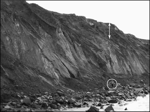
Figure 7 Black-and-white photograph of lower part of unit 3 shows distinctly bedded character of massive pyroclastic-flow (pf), laminated pyroclastic-surge (ps), and fines-poor tephra fallout deposits (tf; shovel about 50-cm long). Upper half of middle pyroclastic-flow deposit displays pink high-temperature oxidation. Dashed lines show partial contacts between beds. Exposure is on west coast several hundred meters south of site of (USGS photograph by W. E. Scott).
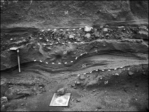
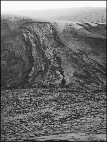
Figure 8 Black-and-white photograph of fine-grained mantle of unit 4 that covers much of island and is susceptible to gullying and shallow landslides on steep slopes. Some slides transform into mud-lump debris flows (foreground). Slope in middle distance is about 30-m high and is part of former sea cliff north of former USFWS cabin (). Slope is covered by thin deposits of units 2 and 3 and 1–2 m of unit 4; slide chiefly involves unit 4. Crater rim is in far distance (USGS photograph by W. E. Scott).