Figures & data
Figure 1 Location of Kasatochi Island in the west-central Aleutian Islands of Alaska.
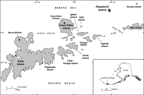
Figure 2 Probability of precipitation in a 1-day period, Adak, Alaska. These probabilities are likely broadly applicable to the general region and thus would generally apply to conditions on Kasatochi Island. Data from Western Regional Climate Center.
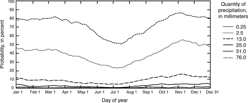
Table 1 Monthly climate data for Adak, Alaska, 1949–2005. Data from Western Regional Climate Center.
Figure 3 Typical gullies on the flanks of Kasatochi volcano. (A) Southeast flank of Kasatochi showing typical gully pattern. Arrow locates person for scale. (B) View looking down the axis of a v-shaped gully on the east flank of the volcano. Maximum gully depth here is about 3 m. Photographs by C. Waythomas, 12 June 2009.
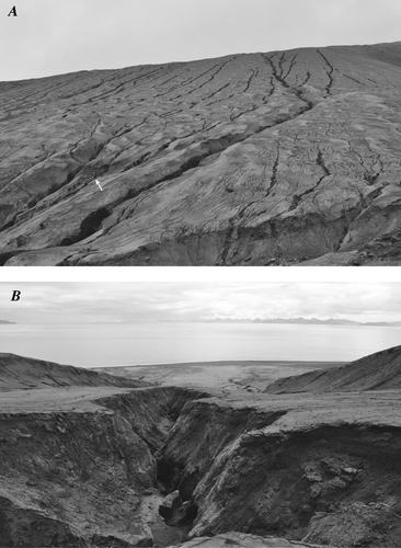
Figure 4 Quickbird satellite image and digital elevation model of Kasatochi Island, 18 April 2009. Drainage basins 1 and 2 indicated by red dashed lines. Basin 1 has a drainage area of 0.72 km2, and basin 2 has a drainage area of 0.52 km2. The contour interval of the DEM is 10 meters and the blue contour inside the crater is −10 meters.
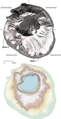
Figure 5 Gully cross sections from two locations on Kasatochi Island. Cross sections A and B are located on the east flank, cross sections C and D are located on the west flank.
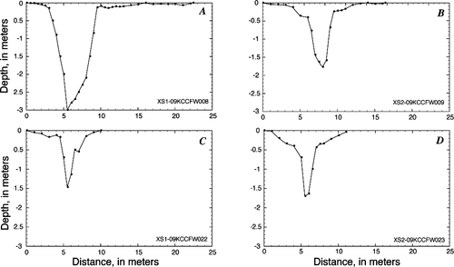
Table 2 Drainage basin area and gully length data as determined from Quickbird satellite images acquired on 17 September 2008, 18 April 2009, and 13 September 2009.
Table 3 Sediment loss and sediment yield estimates for drainage basins 1 and 2.
Figure 6 Coastline along the east side of Kasatochi Island, 22 August 2008, about 2 weeks after the eruption. The beach width at this time was about 2–3 meters, and the bluff on the left is about 1 m in height. The pyroclastic deposits exposed along the coastline are highly susceptible to wave erosion.
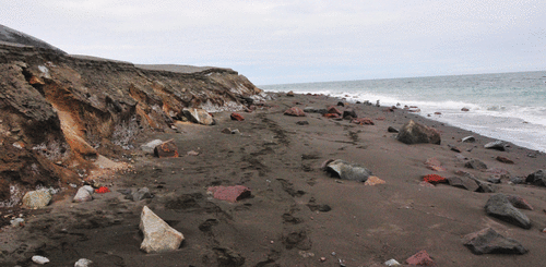
Figure 7 Generalized cross sections of the Kasatochi Island coastline showing pre- and post-eruption morphology. The 2008 eruption extended the coastline about 400 meters seaward, and soon after, wave action initiated beach erosion of the emplaced pyroclastic-flow deposits.
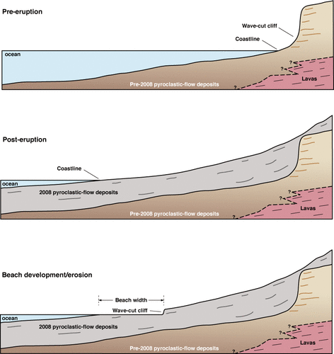
Figure 8 Drainage density versus time since the 7–8 August 2008 eruption for basins 1 and 2. Dashed lines show extrapolated trends based on power-law fits to drainage density data obtained from satellite images on 17 September 2008, 18 April 2008, and 13 September 2009.
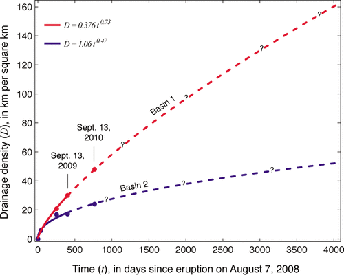
Table 4 Kasatochi Island beach width data. Beach width was measured as the distance from about the middle of the swash zone to the base of the wave cut cliff, or the point of onlap of beach deposits on eruptive deposits, normal to the coastline, as evident in satellite images. The island was divided into four equal quadrants to define the sectors.
Table 5 Major physiographic changes of Kasatochi Island resulting from the 7–8 August 2008 eruption.
Figure 9 Sediment yield versus drainage basin area for drainages affected by volcanic eruptions worldwide (data from CitationLavigne, 2004). Also indicated are sediment yield estimates for the two drainage basins evaluated on Kasatochi Island, calculated using different values for cross-sectional area. This plot shows a general increase in sediment yield with increasing drainage basin area that is characteristic of watersheds on volcanoes affected by deposition of fragmental volcanic debris. No mathematical significance is implied because of the spurious nature of the relation among sediment yield and drainage basin area arising from a common unit in x and y.
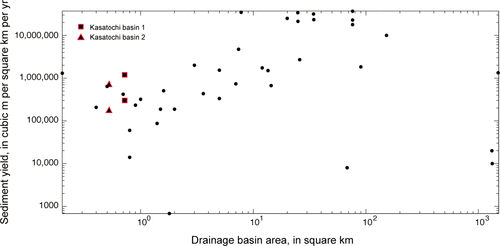
Figure 10 Cumulative sediment volume removed by gully erosion versus time since the 7–8 August 2008 eruption was determined by estimating the amount of sediment eroded from gullies in each of the two drainage basins evaluated for the three time periods for which we have satellite images. The maximum sediment loss estimates were recalculated in terms of a volume per square km and then multiplied by the area of the island (without the crater) to obtain estimates of cumulative sediment volume lost by erosion. It is uncertain if the amount of erosion will follow the power-law fits to this data over the next 5–10 years.
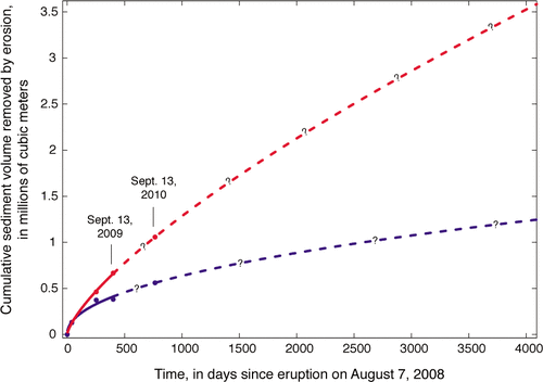
Figure 11 Changes in beach width versus time for each sector of Kasatochi Island. Sector designations shown on . Beach width was measured on satellite images and is the distance from the water line to the emergent wave-cut cliff normal to the coastline.
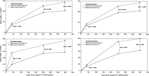
Figure 12 Maps of Kasatochi Island showing the extent of talus and bedrock on 9 April 2004, prior to the 2008 eruption and 13 September 2009, about one year after the eruption. Areas of talus on the island are important nesting habitat for seabirds.
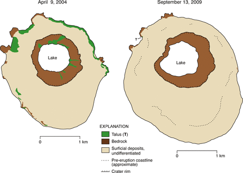
Figure 13 Schematic diagram illustrating the evolution of the gully network on the flanks of Kasatochi volcano and the interplay among sediment delivery to the coast and growth of new beaches. (A) Initial phase of gully development and approximate time of maximum sediment yield. (B) Intermediate phase of gully development and growth of new beaches. (C) Declining phase of gully growth and sediment yield. See text for further discussion.
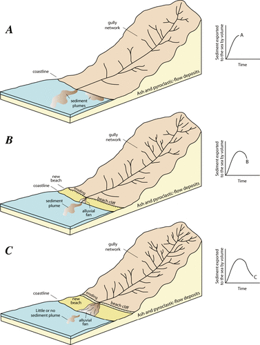
Figure 14 Summary of processes responsible for introducing sediment from Kasatochi Island into the sea.
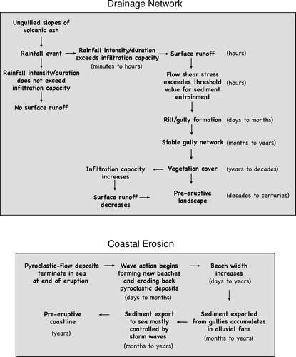
Table 6 Coastline erosion estimates.