Figures & data
Figure 1 Site locations for the 2008 and 2009 samples. Not shown are the locations of a fishing boat from which a sample of the 2008 tephra fall was taken or the grab sample collected near site 13 by William Scott. The boat was approximately 13 km southwest of the island. The sample was collected the following day when the boat returned to port. The base image is from April 2009. Erosion of pyroclastic deposits between 2008 and 2009 place the 2008 sites in the water.
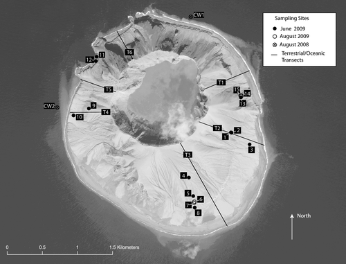
Figure 2 Field photos of selected 2009 characterization pits. (A) Horizon sequence for a profile without shallowly (<1 m) buried soils. (B–D) Profiles for pits in which shallowly buried soils were found. White lines demarcate distinctive horizons with differences in either color, texture, or material (CitationShoeneberger et al., 2002). At all sites with pre-eruptive soils in the profile, roots were seen throughout the soil sequence. (A) Typical sequence of the 2008 pyroclastic deposits found in pits without shallowly buried pre-eruption soils in the profile. Contact between the fine pyroclastic material and the coarse material below is seen at about 30 cm at this site (site 7). (B) Sequence of the 2008 pyroclastic deposits overlying the pre-eruptive soil along the former sea bluff, site 8. This site had a relatively smooth boundary between overlaying 2008 pyroclastic deposits and pre-eruptive soils. No organic horizons were identified at this site. Note that the zero mark of this tape is set at the boundary between the 2008 pyroclastic deposits and the underlying soils. The depth of the pyroclastic deposits was 11 cm. (C) Sequence of the 2008 pyroclastic deposits overlying the pre-eruptive soil along the south slope, site 6. Boundary with the overlying pyroclastic material is wavy; a discontinuous organic horizon is seen between 30 and 35 cm. (D) Sequence of the 2008 pyroclastic deposits overlying the pre-eruptive soils on the eastern slope, site 15. Fibrous and decomposed organic horizons are visible in the profile. The knife blade from shank to point of burial is 16.5 cm.
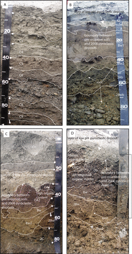
Table 1 Composition of the water-soluble constituents in a 1:20 mixture of Kasatochi Island pyroclastic material to distilled water for samples collected in August 2008 from Kasatochi Island (shaded) and fishing boat (unshaded).
Table 2 Summary statistics for pyroclastic and pre-eruption soil samples collected in June and August, 2009. The p-values for the Mann-Whitney test for significant difference between the median of the pyroclastic and soil groups are also given. Shaded cells indicate the properties for which the median of the pyroclastic deposits is significantly greater than the pre-eruption soils.
Table 3 Nutrient stocks in pyroclastic and pre-eruptive soils. Stocks of available (N—nitrogen, P—phosphorus, and K—potassium), and total nutrients (C—carbon, N—nitrogen, P—phosphorus, and S—sulfur). For site 14 the pre-eruptive soil was exposed and no recent pyroclastic material was present so stocks are calculated only for pre-eruptive soils.
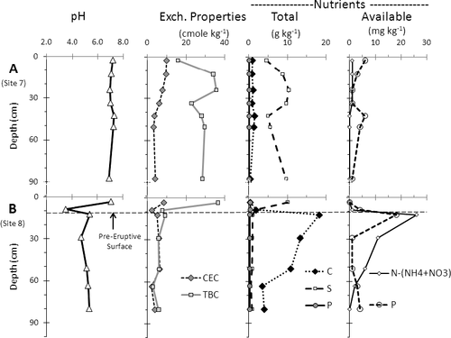
Figure 3 Depth profiles showing typical changes in soil properties (pH; exchange properties: CEC—cation exchange capacity, TBC—total base cations; total nutrients: C—carbon, P—phosphorus, S—sulfur; and Available nutrients: N—nitrogen, P—phosphorus) with depth for (A) a typical pyroclastic dominated site (site 7), and (B) a site with pre-eruption soils in the pit profile (site 8). (Dashed line at 11 cm corresponds to the depth of the overlying pyroclastic deposits across all plots. Note that the zero line for this plot has been adjusted relative to so that zero is at the ground surface.)