Figures & data
FIGURE 1 ASTER image (November 2004) of Khumbu Glacier in the east Nepal Himalaya. Thin white line denotes outline of Khumbu Glacier. White rectangles denote Areas 1 to 4.
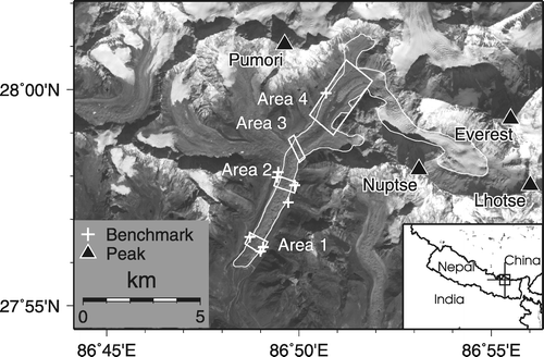
FIGURE 2 Photograph of Khumbu Glacier looking towards Everest and Nuptse from Kala Patar, a peak on the right bank of the glacier. The ice pinnacles are located in Area 4.
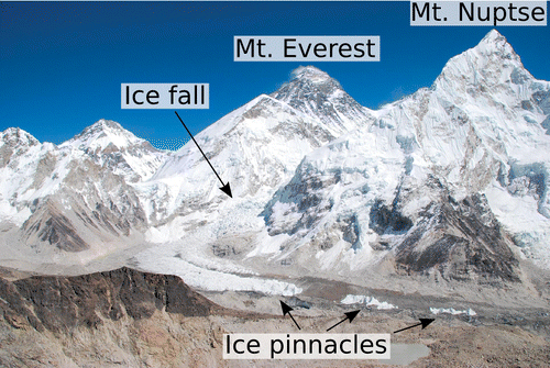
TABLE 1 Summary of survey data analyzed in the present study. The elevation accuracies of contour maps calculated based on the method proposed by CitationD'Agata and Zanutta (2007).
FIGURE 3 ASTER image (2004) of Area 4, showing the outline of ice pinnacles in 1995 (black line). Measurement points are shown at the upper (1) and lower (2) edges of pinnacles A and C (P-A1 and P-A2 for Pinnacle A; P-C1 and P-C2 for Pinnacle C). Two dashed orange lines (UECE and LECE) present the boundaries used for calculating a continuity equation. See the Method section for details.
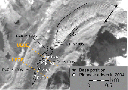
FIGURE 4 Elevation differences between an ASTER DEM and a DGPS DEM, both calculated for November 2004, at different resolutions. Black and gray circles indicate the mean difference, relative to the ASTER DEM, at Areas 1 and 4, respectively. Vertical bars indicate the standard deviation.
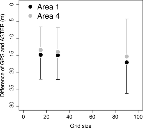
FIGURE 5 Schematic diagram of the volume of glacier considered by the continuity equation. The central cube is the box considered for calculations using the continuity equation. Blue arrows denote glacier flow direction. Transparent boxes on each side of the central cube represent the input and output ice fluxes.
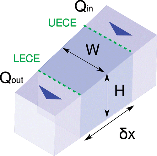
FIGURE 6 Longitudinal distribution of glacier flow velocity during 1987–1995. The data is from CitationSeko et al. (1998). Flow velocities at UECE and LECE are estimated from linear regression of other data.
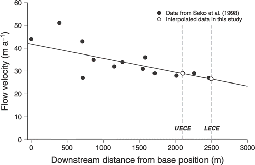
FIGURE 7 DEM differentiation during (a) 1978–1995, and (b) 1995–2004 at 30 m resolution. Thin white line denotes the outline of Khumbu Glacier. The background image is an ASTER image for November 2004.
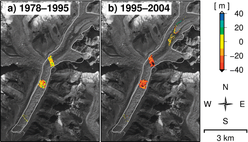
FIGURE 8 Rate of changes in surface elevation during 1978–1995 and 1995–2004 in this study and those during 1978–1995 by CitationKadota et al. (2000). Error bars represent the estimated error.
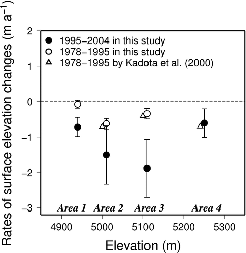
TABLE 2 Statistical summary of the elevation differences among different DEM combinations.
FIGURE 9 Temporal changes in surface flow speed in Area 4 since 1956. Changes in surface flow speed are modified from CitationSeko et al. (1998), using data from the present study. Vertical axis shows the downstream distance from the base position. Thin arrows correspond to ice gaps G1 and G2, which are located on the upper side of Pinnacle A and C, respectively. Thin arrows for the period 1987–1995 correspond to flow velocities measured by SPOT (CitationSeko et al., 1998). Two dashed lines are the upper and lower edges of the continuity equation (UECE and LECE, respectively), with the upper side representing the input side of ice flux, and the lower side representing the output side. The position of each edge is shown in .
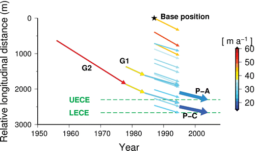
TABLE 3 Summary of the surface flow speed (m a−1) for Khumbu Glacier from 1956 to 2004. Flow data are modified from CitationSeko et al. (1998), along with data of the present study. Data for 1956, 1978, and 1984 are from detailed topographical maps (CitationMüller, 1959; CitationIwata et al., 1980; CitationNational Geographic Magazine, 1988) for which the accuracy is unknown. Data for 1987 are from a SPOT HRV image. Data for 1995 and 2004 are based on ground survey data with an accuracy of less than 1 m.
TABLE 4 Temporal changes in elevation, emergence velocity, and surface mass balance in Area 4 during the periods 1978–1995 and 1995–2004.
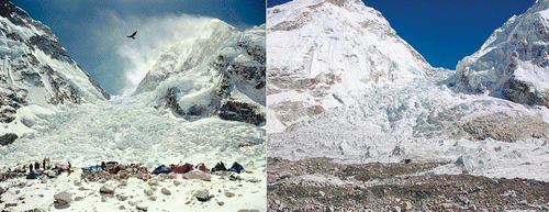
FIGURE 10 Photographs of the icefall of Khumbu Glacier in 1975 (left) and 2004 (right). The photograph in 1975 has been provided by the Yomiuri Shinbun Company.