Figures & data
FIGURE 1 The study area is located in the Pitztal Valley in western Austria, near the village of Plangeross, Sankt Leonhard im Pitztal. The catchment area of the Reiselehnrinne torrent extends from 3343 to 1620 m a.s.l.
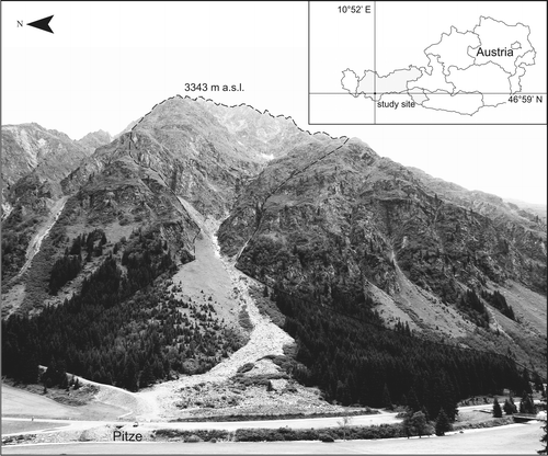
FIGURE 2 The Reiselehnrinne torrent has (A) an incised channel on the upper part of the cone, and (B) no defined channel in the lower part. (C) The debris flow of August 2009 crossed the road and dammed the Pitze river. Photo courtesy of the fire department of Sankt Leonhard, used with permission).
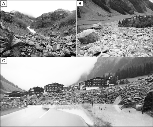
FIGURE 3 Tree ring showing earlywood and latewood cells. The earlywood is subdivided into early early (EE), middle (ME), and late (LE) earlywood and latewood into early (EL) and late (LL) latewood (adapted from CitationStoffel et al., 2005, Citation2006). D is dormancy, and GD is growth disturbances.
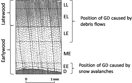
TABLE 1 Classification of GD (growth suppression, growth release, compression wood, TRD, injuries, and callus tissue) after the intensity of the signal. TRD are traumatic resin ducts. Growth disturbances are classified after their intensity into weak (Tw ), intermediate (Tm ), and strong (Ts ) signals as well as injuries (Ti ).
FIGURE 4 Detailed map (original scale 1∶1000) of all debris flow forms and deposits (paleochannels, levees, and lobes) and of the vegetation covering (parts of) the cone (i.e. dense forest, sparse forest, and pioneer trees and shrubs).
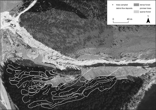
FIGURE 5 Age structure of the forest stand on the Reiselehnrinne cone. The oldest trees are located in the southern part of the cone whereas the trees north of the currently active channel are rarely older than 40 years.
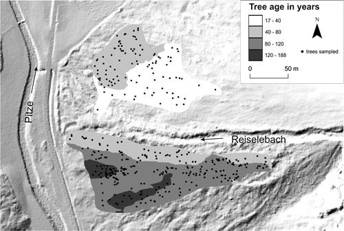
TABLE 2 Index values (It ), weighting factor (Wit ), season index (Si ), and process type for the events reconstructed on the Reiselehnrinne cone.
TABLE 3 Growth disturbances (GD) identified in the 372 Picea abies (L.) Karst. trees. TRD are traumatic resin ducts.
FIGURE 6 Spatial extent of a (A) debris flow (1899) and a (B) snow avalanche (1992) event, the position of trees with GD, as well as all trees available for analysis in these particular years.
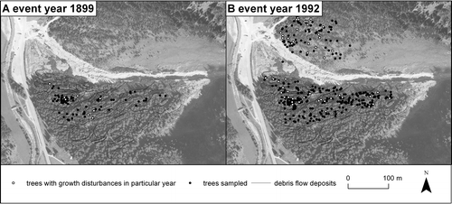
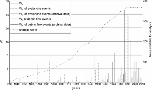
FIGURE 7 Values of Wit (weighted index factor) between 1830 and 2010, with a minimum value of 1.1 following the debris flow event in 2009 and a maximum value of 26.9 caused by an avalanche in 1986.