Figures & data
Figure 1 Land-type map of the upper Whiterocks River watershed. Land types were determined through visual delineation of homogeneous polygons on a large-scale false-color infrared aerial photograph, coupled with field checking. Out of the 3400 ha mapped, 6% is dry meadow, 13% is wet meadow, 56% is continuous forest, 20% is stony upland, 2% is thinly forested stony upland, 2% is open water, and 1% is disturbed (water supply dam). The contour interval in the background is 25 meters, and Whiterocks Meadow is outlined in bold. The inset at upper right shows an enlargement of Whiterocks Meadow overlain on 10-m contours, and the locations of the five soil pits arranged along a transect from coniferous forest (Sites 1 and 2) into the center of the open meadow (Sites 3, 4, and 5). The inset at upper left shows the location of the Whiterocks River headwaters in northeastern Utah.
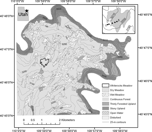
Table 1 Plant species present in Whiterocks Meadow.*
Figure 2 Texture-depth plots for the five soil profiles. Black (left) is clay, dark gray (right) is sand, and the light gray in between represents silt. All values are in percent. The superposition of the three parent materials (loess over glaciofluvial sand over glacial till) in these soils is obvious, and the overall patterns are quite similar. However, clay content is higher under the meadow vegetation (Sites 3, 4, and 5) and B/A clay ratios are higher at the forested sites (1 and 2).
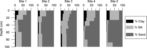
Figure 3 Twelve-month average temperatures for Whiterocks Meadow dataloggers at the soil surface, and depths of 10 and 50 cm. Sites 1 and 2 were located in the forest, Sites 4 and 5 in the meadow, and Site 3 in the open transition zone between the two communities. The dashed line marked the forest-meadow ecotone.
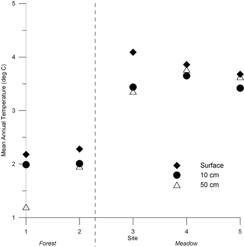
Table 2 Morphological properties of soils along the Whiterocks Meadow transect.*
Table 3 Chemical properties of soils along the Whiterocks Meadow transect.
Table 4 Comparison of horizon properties and profile quantities of weathering products.
Table 5 Summary statistics for the 15 soil temperature dataloggers.
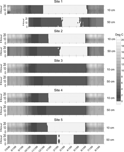
Figure 4 Thermoisopleth diagrams illustrating temperature time-series at 10 and 50 cm below the soil surface at the five study sites. The y-axis on all plots is in hours. The 50-cm logger at Site 1 was deployed later than the others. Stippled pattern marks temperatures near 0 °C. All loggers remained isothermal at, or just below, freezing for several months during the winter. This isothermal period ended nearly simultaneously at the shallow and deep loggers in the open meadow sites (3, 4, and 5), but the 10-cm logger warmed appreciably before the deep logger under the closed forest canopy. Daily maximum temperatures attained by the 10-cm loggers are much greater beneath the open meadow. All dates recorded as mm/d/yy.