Figures & data
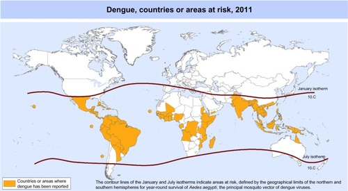
Figure 1 Countries or areas of the world where dengue was reported in 2011, as per data collected by the World Health Organization.Citation32
Notes: Reprinted with permission from the World Health Organization Map Production: Public Health Information and Geographic Information Systems (GIS) World Health Organization. Dengue, countries or areas at risk, 2011. Geneva: World Health Organization (WHO). Available from: http://gamapserver.who.int/mapLibrary/Files/Maps/Global_DengueTransmission_ITHRiskMap.png. July 30, 2013. Copyright © 2012.Citation32 The boundaries and names shown and the designations used on this map do not imply the expression of any opinion whatsoever on the part of the World Health Organization concerning the legal status of any country, territory, city or area or of its authorities, or concerning the delimitation of its frontiers or boundaries. Dotted and dashed lines on maps represent approximate border lines for which there may not yet be full agreement.