Figures & data
Figure 1. Location of inland and offshore sampling sites in the coastal region of southern Taiwan.
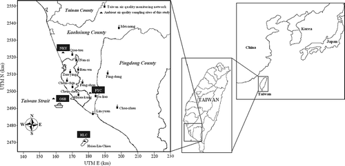
Table 1. Concentrations of PM2.5, PM2.5–10, PM10, and PM2.5/PM10 at the sampling sites in the coastal region of southern Taiwan during the intensive sampling periods
Figure 2. Variation of the size distribution of atmospheric aerosols measured at the (b, d, f) offshore and (a, c, e) inland sites of southern Taiwan during the SLBs periods: (a, b) first, (c, d) second, and (e, f) third sampling period.
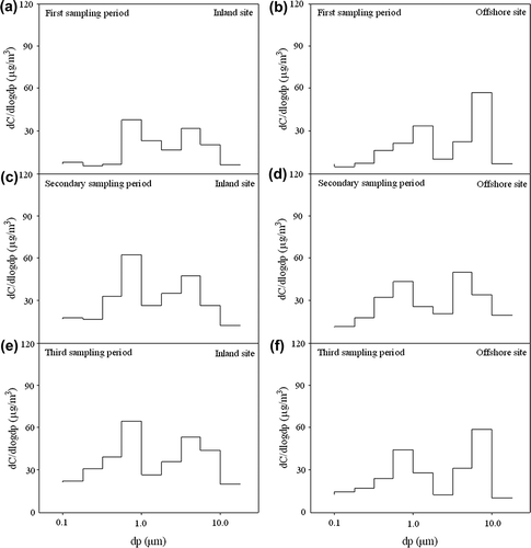
Figure 3. Variation in PM10 concentration with wind speed over the coastal region of southern Taiwan during the intensive sampling periods for the (a) HLC, (b) NKU, and (c) FYC sites.
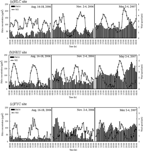
Figure 4. Hourly variation of wind direction over the coastal region of southern Taiwan during the intensive sampling periods: (a) August 16–18, 2006; (b) November 2–4, 2006; and (c) May 2–4, 2007.
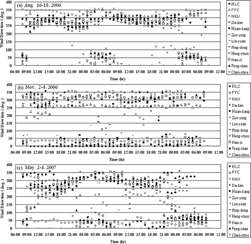
Figure 7. Variations in surface wind field simulated by MM5 over the coastal region of southern Taiwan during the intensive sampling periods: (a) August 16 at 2:00 p.m., (b) August 17 at 2:00 a.m., (c) August 17 at 2:00 p.m., (d) August 18 at 2:00 a.m. (e) November 2 at 2:00 p.m., (f) November 3 at 2:00 a.m., (g) November 3 at 2:00 p.m., (h) November 4 at 2:00 a.m. (i) May 2 at 2:00 p.m., (j) May 3 at 2:00 a.m., (k) May 3 at 2:00 p.m., and (l) May 4 at 2:00 a.m.
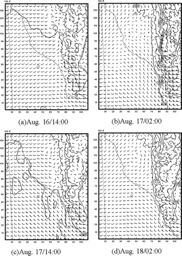
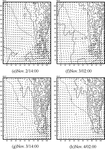
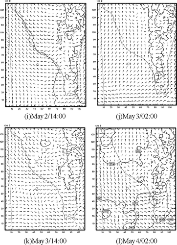
Figure 5. PM10 concentration contour over the coastal region of southern Taiwan during the intensive sampling periods (x- and y-axis legends are UTM [Universal Transverse Mercator] units in kilometers): (a) August 16 at 2:00 p.m., (b) August 17 at 2:00 a.m., (c) August 17 at 2:00 p.m., (d) August 18 at 2:00 a.m. (e) November 3 at 2:00 p.m., (f) November 4 at 2:00 a.m., (g) November 3 at 2:00 p.m., (h) November 4 at 2:00 a.m. (i) May 2 at 2:00 p.m., (j) May 3 at 2:00 a.m., (k) May 3 at 2:00 p.m., and (l) May 4 at 2:00 a.m.
![Figure 5. PM10 concentration contour over the coastal region of southern Taiwan during the intensive sampling periods (x- and y-axis legends are UTM [Universal Transverse Mercator] units in kilometers): (a) August 16 at 2:00 p.m., (b) August 17 at 2:00 a.m., (c) August 17 at 2:00 p.m., (d) August 18 at 2:00 a.m. (e) November 3 at 2:00 p.m., (f) November 4 at 2:00 a.m., (g) November 3 at 2:00 p.m., (h) November 4 at 2:00 a.m. (i) May 2 at 2:00 p.m., (j) May 3 at 2:00 a.m., (k) May 3 at 2:00 p.m., and (l) May 4 at 2:00 a.m.](/cms/asset/6622b09c-7eb8-4459-90a2-cbd306ac8fa1/uawm_a_10412104_o_f0005g.gif)
![Figure 5. PM10 concentration contour over the coastal region of southern Taiwan during the intensive sampling periods (x- and y-axis legends are UTM [Universal Transverse Mercator] units in kilometers): (a) August 16 at 2:00 p.m., (b) August 17 at 2:00 a.m., (c) August 17 at 2:00 p.m., (d) August 18 at 2:00 a.m. (e) November 3 at 2:00 p.m., (f) November 4 at 2:00 a.m., (g) November 3 at 2:00 p.m., (h) November 4 at 2:00 a.m. (i) May 2 at 2:00 p.m., (j) May 3 at 2:00 a.m., (k) May 3 at 2:00 p.m., and (l) May 4 at 2:00 a.m.](/cms/asset/81449323-e428-43f5-a26b-9ee3d2f1365f/uawm_a_10412104_o_f0015g.gif)
![Figure 5. PM10 concentration contour over the coastal region of southern Taiwan during the intensive sampling periods (x- and y-axis legends are UTM [Universal Transverse Mercator] units in kilometers): (a) August 16 at 2:00 p.m., (b) August 17 at 2:00 a.m., (c) August 17 at 2:00 p.m., (d) August 18 at 2:00 a.m. (e) November 3 at 2:00 p.m., (f) November 4 at 2:00 a.m., (g) November 3 at 2:00 p.m., (h) November 4 at 2:00 a.m. (i) May 2 at 2:00 p.m., (j) May 3 at 2:00 a.m., (k) May 3 at 2:00 p.m., and (l) May 4 at 2:00 a.m.](/cms/asset/87d8a12b-7745-4c41-aa65-7dcb845088cf/uawm_a_10412104_o_f0016g.gif)
Table 2. Results of the paired t test for comparing the daytime and nighttime PM10 concentrations at inland and offshore sites
Figure 6. Backward trajectories of air parcels transported to the inland sampling sites over the coastal region of southern Taiwan during the intensive sampling periods (x- and y-axis legends are UTM in kilometers): (a) August 16–18, 2006; (b) November 2–4, 2006; and (c) May 2–4, 2007.
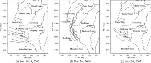
Figure 8. The vertical wind field profile in the coastal region of southern Taiwan on August 16 at (a) 2:00 p.m. and (b) 8:00 p.m.
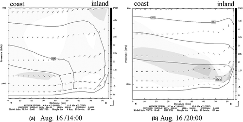
Table 3. Correlation coefficients of the model simulation and the measurement at inland and offshore sites during the sampling periods
Figure 9. Spatial distribution of PM10 concentration simulated by CAMx over the coastal region of southern Taiwan during the intensive sampling periods (x- and y-axis legends are UTM in kilometers): (a) August 16 at 2:00 p.m., (b) August 17 at 2:00 a.m., (c) August 17 at 2:00 p.m., (d) August 18 at 2:00 a.m. (e) November 2 at 2:00 p.m., (f) November 3 at 2:00 a.m., (g) November 3 at 2:00 p.m., (h) November 4 at 2:00 a.m. (i) May 2 at 2:00 p.m., (j) May 3 at 2:00 a.m., (k) May 3 at 2:00 p.m., and (l) May 4 at 2:00 a.m.
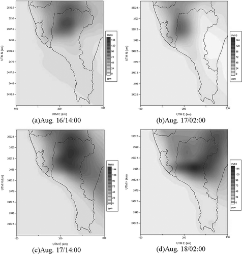
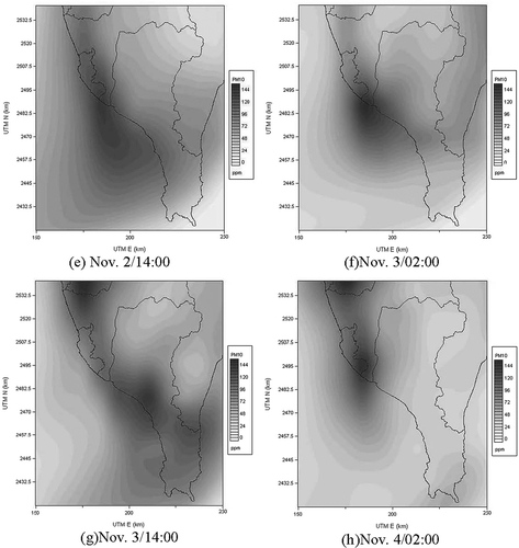
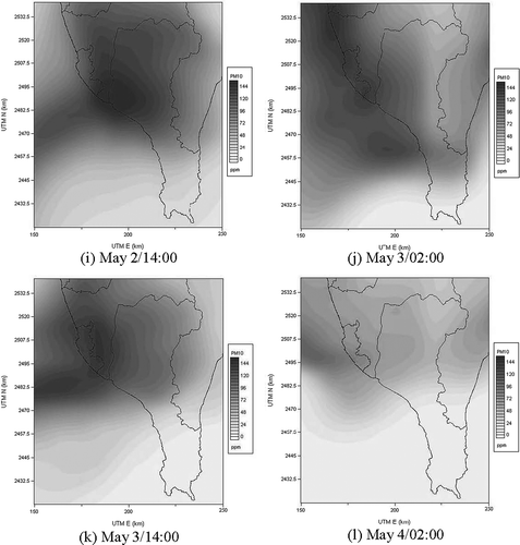
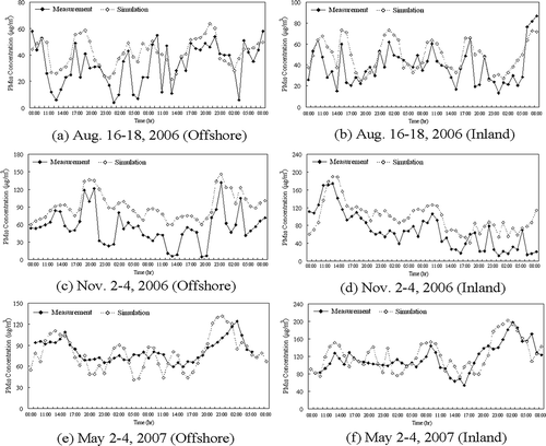
Figure 10. Comparisons of hourly surface PM10 concentrations at inland and offshore sites during the sampling periods: August 16–18, 2006 (a) offshore and (b) inland; November 2–4, 2006 (c) offshore and (d) inland; and May 2–4, 2007 (e) offshore and (f) inland.