Figures & data
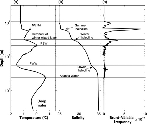
Fig. 1 Schematic illustrating the range of ocean observing techniques deployed annually by the two icebreakers of the Canada Three Oceans project (C3O) along a 15 000 km track through Canada's Pacific, Arctic and Atlantic waters. (Figure used with permission of E. Carmack.) Abbreviated terms: conductivity–temperature–depth recorders (CTD); ice-tethered profiler (ITP); McLane moored profiler (MMP); and acoustic Doppler current profiler (ADCP). See Carmack et al. (Citation2010) for a detailed description of the observing scheme.
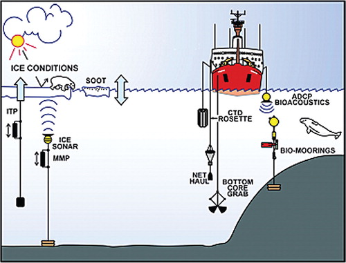
Fig. 2 Upper-ocean temperature transects across the Arctic Boundary Current from Fram Strait to the New Siberian Islands between 2003 and 2009, supplemented with Canada Three Oceans and Joint Ocean Ice Study transects across the continental margin of the Canada Basin in 2003–09. (This figure was originally printed by Polyakov et al. (Citation2011). © American Meteorological Society. Reprinted with permission.) Note that this figure captures the passage of two separate pulses of warmth around the Arctic margin. The wave of warmth that is currently passing around the Canada Basin reflects the relative warmth of Atlantic inflow to the Arctic in the early to mid-1990s, while that shown off the Laptev Sea around 2007–08 reflects the extreme warmth of inflow in the early to mid–2000s.
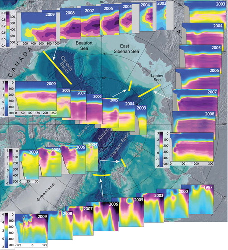
Fig. 3 Water mass structure of the Canada Basin as characterized by (a) temperature, (b) salinity and (c) Brunt-Väisälä frequency profiles. (This figure was originally printed in Jackson et al. [Citation2010] and is reproduced here with permission of J. Jackson.) Note the depth axis is log scale. In summer, there are up to three temperature maxima (the near-surface temperature maximum [NSTM], Pacific Summer Water [PSW] and Atlantic Water), two temperature minima (the remnant of the previous winter's surface mixed layer and Pacific Winter Water [PWW]), and three haloclines (the summer halocline, the winter halocline and the lower halocline).