Figures & data
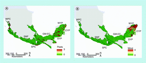
(A) Pests and diseases; (B) wind. Scale: 1 = very light to 4 = severe.EYP: East Yucatan Peninsula; GM-EC: The Gulf of Mexico and eastern Chiapas; SMF: Sierra Madre Foothills; SPC: South Pacific Coast; SYP: South Yucatan Peninsula; WPC: West Pacific Coast; WYP: West Yucatan Peninsula.
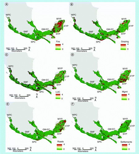
(A) Fire; (B) grazing; (C) land-use change; (D) forest management; (E) roads; and (F) settlements. Scale: 1 = very light to 4 = severe.
EYP: East Yucatan Peninsula; GM-EC: The Gulf of Mexico and eastern Chiapas; LUC: Land-use change; Mgmt: Forest management; SMF: Sierra Madre Foothills; SPC: South Pacific Coast; SYP: South Yucatan Peninsula; WPC: West Pacific Coast; WYP: West Yucatan Peninsula.
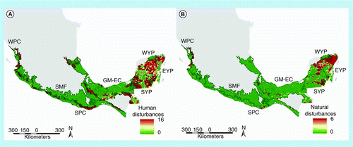
(A) Human disturbances; and (B) natural disturbances. Human disturbances scale: 0 = no disturbance to 16 = severe; natural disturbances scale: 0 = no disturbance to 6 = severe.
EYP: East Yucatan Peninsula; GM-EC: The Gulf of Mexico and eastern Chiapas; SMF: Sierra Madre Foothills; SPC: South Pacific Coast; SYP: South Yucatan Peninsula; WPC: West Pacific Coast; WYP: West Yucatan Peninsula.
(A) Biomass clusters and outliers. (B) Aboveground living biomass, derived from the inverse weighted distance interpolation.
EYP: East Yucatan Peninsula; GM-EC: The Gulf of Mexico and eastern Chiapas; H-H: Clusters of high biomass plots; H-L: Outlier of a high biomass plot within a cluster of low biomass plots; L-H: Low biomass plot within a cluster of high biomass plots; L-L: Clusters of low biomass plots; SMF: Sierra Madre Foothills; SPC: South Pacific Coast; SYP: South Yucatan Peninsula; WPC: West Pacific Coast; WYP: West Yucatan Peninsula.
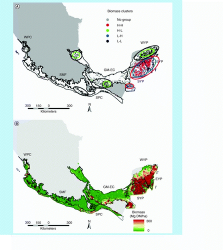
Table 1. Brief outline of human and natural disturbances.
Table 2. Number of plots used in the analysis with human disturbances, with natural disturbances, without disturbances and all plots in each ecoregion.
Table 3. Average biomass densities in high, low and outlier categories in all plots and in all ecoregions.
Table 4. Multiple variable ANOVA with biomass clusters, human and natural disturbance presence/absence as independent variables and a square root conversion of the aboveground biomass data as dependent variable.
Table 5. ANOVA and Tukey´s test for homogeneous groups of aboveground living biomass, according to the intensity of the specific disturbance.
Table 6. Statistically significant coefficients of the multiple linear regressions between a square root conversion of the aboveground biomass data and specific human disturbances for each ecoregion (p < 0.01).
Table 7. Level of biomass reduction in plots with human disturbances in percentage of a square root conversion of the aboveground biomass data of undisturbed plots, applying the regression equations of Table 6.