Figures & data
Figure 1. The Magpie River watershed, showing stream segment from the outlet of Esnangi Lake to Steephill Falls reservoir (70 km2).
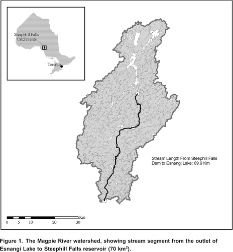
Figure 2. Long term series of mean annual air temperature (a) and precipitation (b) in the Magpie River watershed from 19702000. The dashed line in the temperature and precipitation plots represents (a) 2.0C and (b) 1014 mm yr1, respectively. Data obtained from Wawa (Aut) weather station (ID: 6059468).
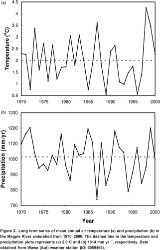
Figure 3. The conceptual diagram of the model presented in this study. Evapo signifies evaporation from the reservoir. HER signifies hydrologically effective rainfall. L1 = minimum reservoir level, L2 = maximum reservoir level, SMD = soil moisture deficit, FC = Field capacity, SM = soil moisture (see Table 1 for more parameter descriptions).
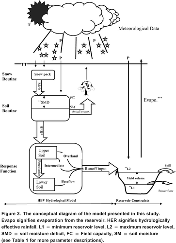
Table 1. Model parameter values and definitions for the Batchawana River and Steephill Falls reservoir constraints.
Figure 4. Discharge-power empirical relationship used to estimate reservoir level response to energy production in the model. Turbine flow = 2.56power + 2.36.
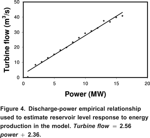
Figure 5. Result of CGCM3 downscaling, showing non-homogeneity in future air temperatures under IPCC (a) A1B; dashed line = 3.6C, solid line = 4.9C (b) A2 scenarios; dashed line = 3.7C, solid line = 5.7C.
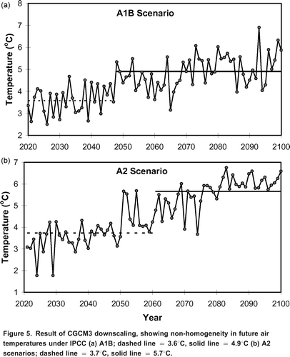
Figure 6. Mann-Kendall trend test and Sen's slope estimate for the projected climate change scenarios shown in . The charts represent (a) A1B scenario and (b) A2 scenario.
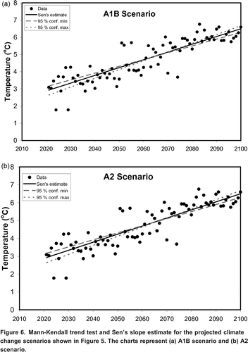
Figure 7. Seasonal dynamics of CGCM3 of projected air temperature (a) A1B scenario, (b) A2, and of precipitation (c) A1B scenario, (d) A2.
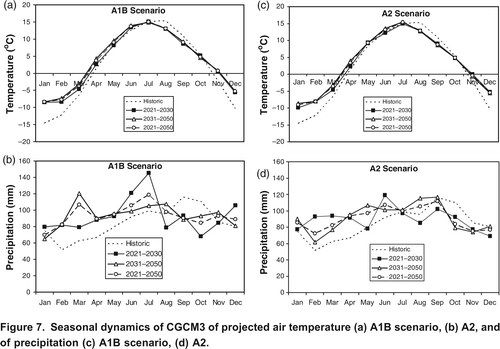
Figure 8. Discharges rate in (a) the regulated Magpie River from 20012006 and (b) the non-regulated Batchawana River from 20042009 in comparison to HBV simulated streamflow (NS = 0.68).
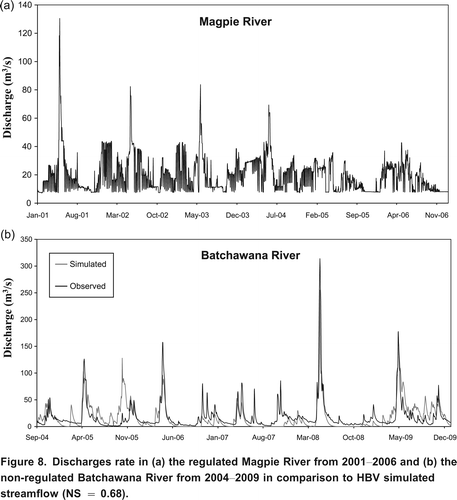
Figure 9. Comparison of (a) runoff dynamics and (b) cumulative flow, between unregulated Batchawana River and regulated Magpie River at Steephill Falls during the overlapping period Sept. 2004 Dec. 2010.
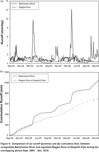
Figure 10. Results of reservoir level simulation (a) during the calibration period June 2004 to September 2006 and (b) seasonal dynamics of observed vs. simulated reservoir levels within the calibration period.
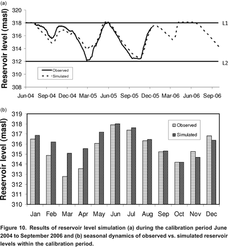
Figure 11. Projected long term response in reservoir levels to climate change under (a) A1B scenario and (b) A2 scenario, plus a hypothetical 25% increase in energy production.
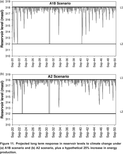
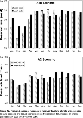
Figure 12. Projected seasonal response in reservoir levels to climate change under (a) A1B scenario and (b) A2 scenario plus a hypothetical 25% increase in energy production in 20202050 vs 20312050.