
ABSTRACT
Sequence stratigraphy is a major research subject in the geosciences academia and the oil industry. However, the geoscience education literature addressing students' understanding of the basic concepts of sequence stratigraphy is relatively thin, and the topic has not been well explored. We conducted an assessment of 27 students' conceptions of four central principles of sequence stratigraphy. Ten juniors, 15 seniors, and two graduate-level students were enrolled in undergraduate stratigraphy courses at three research-intensive universities in the midwestern United States. Fifty percent of students were majoring in geology and forty percent in environmental geosciences. Data collection methods included semistructured (videotaped) interviews, which were conducted after the sequence stratigraphy lectures. Using constant comparative analysis, we documented students' conceptions about eustasy, relative sea level, base level, and accommodation. Results indicated that students poorly integrated temporal and spatial scales in their sequence stratigraphic models, and that some alternative conceptions are more deeply rooted than others, especially those related to eustasy and base level. Additionally, students frequently omitted subsidence as another controlling factor on accommodation. Other findings indicated a low level of familiarity with the classic marginal marine profile and associated sedimentary structures. This study documents the most critical concepts likely to be resistant to conceptual change through instruction in sequence stratigraphy.
Acknowledgments
We express our gratitude to Professors Lisa Pratt, Jim Ogg, and Brian Hampton for their kindly collaboration, allowing us to conduct our research in their classes. We are also thankful to: Jim Ogg, Chris Kendall, Duncan Sibley, and Brenda Capobianco. We acknowledge Purdue University Institutional Review Board (IRB), for granting approval to conduct research involving human subjects. We thank colleagues who helped to independently code the data, Lana Zimmer, Laura Weber, and Jiyoung Yi. Our recognition also goes to all the student participants who volunteered for this study. We appreciate comments, suggestions, and revisions of two external research peers for strengthening and improving the final document.
FIGURE 1: Distinction among relative seal level, global sea level (eustasy), and water depth (after CitationCoe et al., 2005).
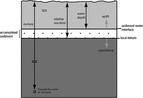
FIGURE 2: Drawing from student “B.” This student seems not to distinguish total water depth from global depth (as inferred from the quote and the figure above). We infer that student B's arrow indicated the datum as the seafloor. Our case is that he understands global change solely as a volumetric change in water (no volumetric change in the basin).
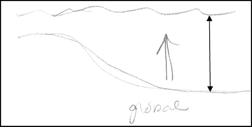
FIGURE 3: Most common factors that students associated with global sea-level change. “Melting of the ice caps,” with 12 entries (45%), is one of the most reported factors as causing global sea-level change. Other factors (7%) refer to sea thermal expansion. Very few students (20%) combine two or more factors.
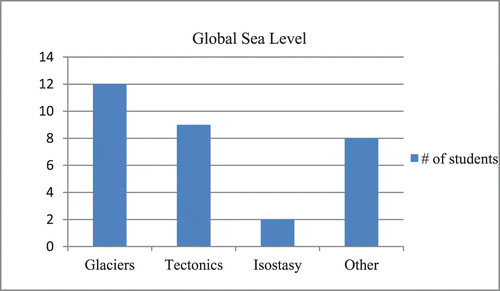
FIGURE 4: Drawing from student “E.” He associated relative sea-level change with tides (daily change in “small” tidal amounts), which is another example of a misconceived timescale in relative sea-level change, “daily amount of change.” Also notice that the point of reference to measure the change is again the arrows pointing to what we interpret as the seafloor, not to a local datum.
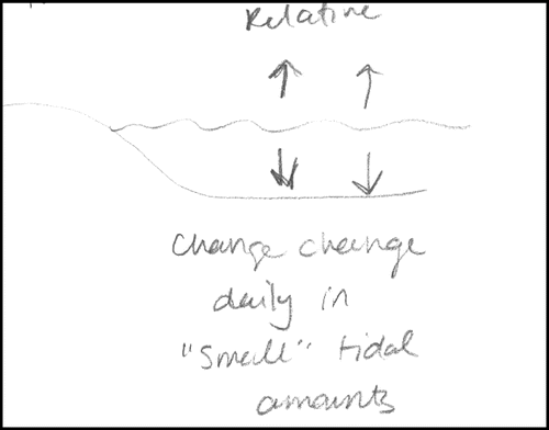
FIGURE 5: Common factors that students associated with relative sea-level change. Local area refers to any change in a local region (e.g., change in local watershed runoff); there is not always a specific mention to what type of change.
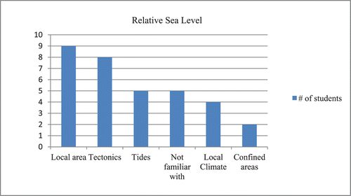
FIGURE 6: Student “La” drawing for questions related to base level. This student assumes base level as the elevation point at the top of bedrock. It is arguable that base level may change by tectonic input (this drawing distantly may represent that case). However, what is missing here is the relationship with the shoreline due to sea-level fluctuation that changes base level, and the space available for deposition.
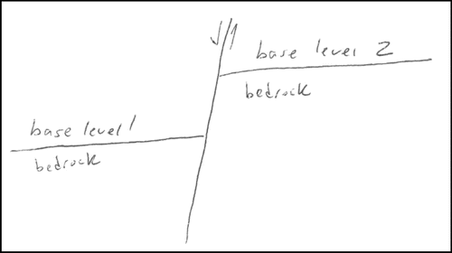
FIGURE 7: Graph summarizing base-level notions. Eight students reported being unfamiliar or not remembering hearing about the concept of base level before.
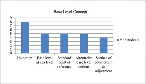
FIGURE 8: Summary of students' responses on questions related to base level, relative sea level, and global sea level, placed on the continuum of science conceptions.
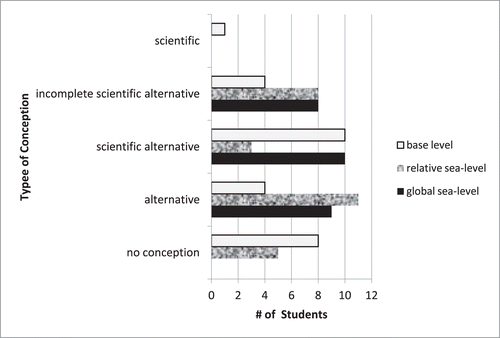
FIGURE 9: Students' responses to the concept of accommodation ranked based on the numbers of factors described properly that control it. The more factors reported do not imply a more complete understanding of the concept of accommodation. Squares = juniors, circles = seniors, triangles = graduates.
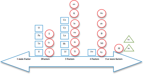
FIGURE 10: Graph illustrating students' responses of the most common factors controlling sediment deposition in a place. Note that subsidence has 0 entries.
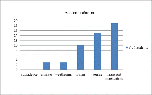
TABLE I: Participant demographics. All students had taken two geology-based courses (e.g., introductory geology and historical geology). All the other course work varied according to college level, and type of major (e.g., igneous petrology, structural geology, paleontology, typically for geology majors, and hydrology, environmental geosciences, and geochemistry for environmental geosciences majors).
TABLE II: Coding rubric.
TABLE III: Conception categories (after CitationSexton, 2008).