
Abstract
This paper is an historical case study of a major flood that occurred in British Malaya in 1926. It focuses on two key points. First, that the magnitude and subsequent impacts of the flood were exacerbated by contemporary industrial, agricultural, and hydraulic practices. Second, that this event pushed the British colonial government toward improving their land and river management strategies over the following decades. This article draws on recent research arguing the importance of an historical approach to disaster, as it enables greater insight into a disaster's causes and long‐term political, social, and environmental ramifications. Focussing on December 1926—a month of especially severe flooding likely linked to La Niña—this article will explore how those inundations became disastrous because of man‐made changes enacted on the local environment. It will consider the sequential effect of the inundations, from their immediate to medium‐term impact on the environment, to subsequent government‐led flood mitigation schemes. By viewing the mid‐1920s floods as a catalyst for change, with the benefit of hindsight, it is also possible to assess how far these changes were positive or negative.
Introduction
This paper draws on recent developments in historic hydrology and historic disaster research. Its first aim concerns historic hydrology, which has been led by studies focussing on Europe and India (Brádzil et al. Citation2006, D'Souza Citation2006, Rohr Citation2013), but far fewer have concentrated on South‐East Asia. This paper aims to go some small way to fill that gap. The second is that Asian flood disasters are most often studied within modern contexts, but a recent and increasingly productive engagement by historians in disasters has shown how historic studies reveal insights which can be useful today (Bankoff et al. Citation2004, Schenk Citation2007, Mauch and Pfister Citation2009). With the benefit of a long view, historians can consider questions such as sociocultural resilience or vulnerability and cause and effect over the medium to long term. Indeed, drawing from recent strands of environmental and climatic history, historians have been inspired to look more closely at disaster as a way of exploring long‐term processes in the relationship between nature, humanity, and culture (Schenk Citation2007, p. 16). By taking this approach, this paper uses an historic case study as its base, to extrapolate the sequential effect of the disaster in question.
It explores one of the worst episodes of flooding in the history of British Malaya that took place over December 1926. Occurring during the northeast monsoon and an especially strong ENSO cycle, it argues that—despite the severe weather—the magnitude and subsequent impacts of the flood were exacerbated by the rapid development of commercial industry and agriculture and by the British colonial government's limited hydraulic management. It then moves on to suggest that although the 1926 floods pushed the government toward greater investment in hydraulic planning, this transition was neither linear, nor always positive. It will begin by placing the article in context by providing an overview of contemporary knowledge of environmental change and also by exploring the unusual weather conditions of the mid‐1920s. The main body will be the case study of the flood which will move into a discussion of the immediate and longer‐term response by the British government. Finally, it will consider the development of flood management under British rule, the effectiveness of subsequent hydraulic strategies, and argues that the problems encountered by the government then still persist in many places today.
The research for this article comprises an extensive survey of historical documentary sources relating to the “Great Flood” of 1926 and post‐flood governmental responses. A majority of the sources comprised minutes from extant governmental and municipal council minutes, alongside newspaper reports. These primary sources included archival, printed, and digitized documents for a period of approximately 20 yr surrounding the flood. The study did not seek to move further forward in time, as Malaya was under siege by Japanese forces from 1941 to 1945 thus effecting a break in normal governmental administration and spending for this period and beyond. Focussing on the 1920s and 1930s then, it was possible to build a case study of the event itself and to assess how the government responded through policy changes and the development of improved flood mitigation strategies immediately afterward and in the longer term. The primary documents included contemporary newspapers digitized by the National Library of Singapore (online) and original correspondence, weather observations, and reports made by the British colonial government in Malaya (held at national archives). This encompassed minutes from the Legislative Council, the main body responsible for governance across the Straits Settlements, Public Works Department (PWD) reports, and District Officer (DO) reports. These sources are held at the National Archives of Singapore (NAS) and the National Archives of Malaysia (NAM). Printed contemporary sources include the Straits Settlements' Annual Reports and Medical Reports which contain meteorological observations, public works digests, and general information about the colony's activities. Contemporary photographs of the floods come from the archives of the British Association of Malaysia and Singapore (BAM) which are held in the Royal Commonwealth Society collection at Cambridge University archives, UK.
Background and Context: British Malaya, Contemporary Environmental Thought and Extreme Weather
The British gained their first foothold in the Malay Archipelago in 1786 by establishing a defensible trading post at Penang Island. With the founding of a new settlement at Singapore in 1819 and the takeover of Dutch Malacca in 1824, the British managed key strategic locations on the western peninsula known collectively as the Straits Settlements. Over the course of the 19th century, they expanded their territorial sovereignty to include the states of Selangor, Perak, Negri Sembilan, and Pahang (the Federated Malay States or FMS), with the eventual extension of indirect rule to the states of Johor, Kedah, Kelantan, Perlis, and Terengganu as British protectorates (Unfederated Malay States or UNFMS). Although originally interested in developing trading ports, the British were quick to develop and transform Malaya's natural resources, experimenting with new commercial crops and agricultural methods.
Shifting cultivation—the predominant form of agricultural activity—was in many cases supplanted by medium‐ to large‐scale commercial plantation. Native staples, including gambier and pepper, began to be farmed on a commercial scale for an overseas market. New species were introduced with varying levels of success, including coffee and sugar. The real winner was rubber. Despite an inauspicious start, research by botanists including Henry Ridley, combined with the commercial failure of locally produced coffee and high global prices for rubber, inspired interest. By 1897, the government were actively encouraging investors by offering favorable lease terms for rubber plantation and by granting a federal loan of $4,000 for rubber experimentation in 1900 (Lim Citation1977, pp. 31–2). By the 1904 global rubber boom, Malaya was well placed to become a major market competitor.
Commercial mining operations, especially in tin, were also advanced. Mining had a major impact on the rural and semi‐rural landscape, and impacted rivers by adding pollutants and clogging them with waste. Plantation and mining required large numbers of workers. This, and the lure of opportunity, swelled immigration. Immigration transformed makeshift settlements into new towns by the latter half of the century, particularly at Ipoh and Kuala Lumpur, marking a shift from a rural to an urban economy. The landscape was also changed by the development of the infrastructure needed to support these commercial agricultural and industrial activities, including the building of railways and roads to link major towns, and airfields to service them. By the 1920s, motor cars were adding to town congestion and, in 1926, a major scheme for national and international air travel was being considered. The proposals vaunted a revolution in passenger and cargo transport. A flight between Singapore and Penang Island by air, for example, was expected to take only 3 h and 15 min (NAS, NAB 2438, CitationM712/14‐15, f.84‐5). In the years to come, the clearing of land for airfields was to become a major source of social contention and contributed to urban flooding problems (the 1954 floods at Paya Lebar and Bedok in Singapore are a case in point).
From the 1880s, there had been growing concern about the impact that this development was having on the environment. Nathanial Cantley, Superintendent of the Singapore Botanic Gardens and latterly the Straits Forest Department from 1880, conducted a survey of the Straits Settlements forests in 1885. This was in direct response to the government's call to investigate deforestation caused by mass agricultural clearances (CitationStraits Times, 24 April 1886, p. 2, Kong and Yeoh Citation1996). Cantley's subsequent critical report told how virgin jungle was fast being felled by planters and mine owners and argued that deforestation would diminish rainfall. Under Henry Ridley, Cantley's successor from 1888, over 88,336 acres of forest land were reserved (Tan Citation1999). Reserving was intended to prevent soil erosion and to lessen the impact of desiccation (Corlett Citation1995, p. 7), a theory that connected man‐made environmental change with localized climatic change (Logan Citation1848). The theory was not new; indeed, it had first been mooted by the ancient Greeks, but it was the 18th century before it was recognized as a “scientific” theory. In the Straits Settlements, research conducted on deforestation, rainfall, and humidity was reflected in the government's reforming agenda necessary to address the increasingly apparent problem of wanton environmental destruction in many colonies (Grove Citation1995, pp. 2–6, 468–70). Increasing interest in, and knowledge of, how colonization was impacting on natural landscapes also crossed over into understanding the causes of floods. Contemporaries recognized that deforestation, mining operations, land reclamation, and urbanization had caused river sedimentation, increased surface water pooling, and even changed stream flow. Desiccation, it was believed, added to the problem by changing rainfall patterns (Matthews Citation2011, p. 40). While colonial science may be flawed by modern standards, the connection of man‐made development with the increased frequency and severity of flooding held much truth. It is perhaps no surprise that these theories gained momentum in the late 19th and early twentieth century because, as we now know, this was also a period of unusually strong El Niño Southern Oscillation (ENSO) variations. This created extreme and unstable weather conditions (especially 1891–2, 1910–11, 1916–17, 1925–6: Quinn, Citation1992, Davis Citation2001, p. 235).
The mid‐1920s saw a particularly strong ENSO cycle. Allan and D'Arrigo (Citation1999) whose research analyzes documentary evidence for the Southern Oscillation Index (SOI) and Sea Surface Temperature (SST) suggest a protracted Na Niña event between 1920 and 1924 based on data provided by Quinn and Neal (Citation1992). The data set produced by Cook (Citation2000) for the Nino 3 region corroborates this, recording SSTs equating to a strong La Niña event during December 1925–February 1926. Gergis et al. (Citation2006, p. 712) ENSO reconstruction for the Nino 3.4 region reveals a SOI anomaly and low SSTs over the same period, with the lowest SSTs occurring in 1926. Despite slight variances, it is largely agreed that the mid‐1920s witnessed one of the strongest ENSO events of the twentieth century, with La Niña occurring in 1926 (Qian et al. Citation2011, p. 6492). Unusual weather conditions affected large parts of the world. Flood, famine, or drought was experienced in Africa, New Zealand, America, China, and India (Barry Citation1997, Davis Citation2001, Coggins Citation2011, CitationNIWA, 2013). In Malaya, 1925 and 1926 saw severe flooding during both northeast monsoon seasons (November–January). The ENSO cycle is important in producing unusually severe weather and heavy rainfall in Malaya but, as we shall see, this was not the sole cause for the scale and magnitude of the ensuing floods.
The 1926 Flood and its Impacts
After celebrations were drawing to a close on Christmas night 1926, the British government officials then stationed in Kuala Lumpur had no idea of the destruction the remaining days of that year would bring. For the next 50 h, rain would fall on the city almost unceasingly. On 27 December, the local press gave expression to fear that with parts of the town already saturated, rising river levels would trigger a serious disaster (CitationSingapore Free Press and Mercantile Advertiser, 29 December 1926, p. 10). Their prognosis would come true within 24 h. The Rev. D. Fergus Ferguson of St Andrews Presbyterian Church in Kuala Lumpur later described what would enter popular memory as the “Great Flood of 1926.” Ferguson recalled how there was a “metre of water in the centre of K. L. Office and shop workers paddled to work in sampans and, when the waters receded, the Chartered Bank spread millions of soggy bank notes to dry on the Selangor Club's padang [field]” (CitationSt Andrews, 2016). Flood waters that had subsided a little by the morning of 30 December were rising again by noon that same day. An observer told how “surely but steadily the water has again begun to overflow the streets. The padang, which was clear this morning is once again under water and on all sides the water is rapidly rising.” The record‐breaking inundation saw six‐foot‐deep waters in some places, making communications “between one portion of the town and the other … totally impossible.” A five‐foot‐deep “lake” formed, cutting off the Empire Hotel from the Klang River, and at “Old Market Square and the business offices, the water was over four feet deep.” Disruption was considerable. The department stores “Whiteaway's and John Little's … were under water nearly a foot” (CitationStraits Times, 30 December 1926, p. 9). All rail services passing north out of the city were suspended, affecting mail, passengers, and freight. Sixty passengers traveling third class from Singapore to Ipoh were stranded in Kuala Lumpur, for example. Lacking money for overnight accommodation or food, they were lodged at the generosity of the Kwong Siew Wooi Koon Association (CitationStraits Times, 5 January 1927, p. 2).
To assume however that the extreme weather conditions were the only causal factor for the Malayan Great Floods of December 1926 would not be telling the whole story. Indeed, taking the annual rainfall average over the period 1869–1926 as a baseline (2,342 mm), 1926 experienced high, but not exceptional, rainfall across Malaya. Across the settlement as a whole, 1925 had been much wetter at 2,726 mm as opposed to 2,409 mm in 1926 (Citation1998 Jarman, Vol. 8, p. 604). In fact, medical reports for 1926 noted the unusually dry weather, especially over the summer months (Citation1998Jarman, Vol. 8, 1926, p. 662). At Singapore and Penang Island precipitation had been higher in 1925 without the large‐scale flooding of 1926 (Citation1998 Jarman, Vol. 8, 1926, p. 579, CitationHoops, 1927, p. 162). Neither can we assume that an unusual concentration of rain over a short period was the sole cause as the highest monthly rainfall recorded at either station had actually occurred during October (Citation1998Jarman, Vol. 8, p. 579). Unfortunately, we cannot draw any definite conclusions without a full set of precipitation observations. Rain gauges were not kept systematically outside of the major towns until after 1929 (Citation1998 Jarman, Vol. 9, p. 355). A few estates and mines kept their own rain gauges and records however. In Kemanan (Chukai), Terengganu, for instance, mining engineer A. P. Henggeler kept monthly rainfall sheets. The December sheet recorded a fall of 15.21 inches (386 mm) on the 26th, 15.50 (394 mm) on the 27th, thereafter falling to 10.54 inches (268 mm) on the 29th with a steady drop to normal levels by the following day. The monthly total was 76.54 (1,944 mm) with the majority of this between 21 and 29 December. In Kuantan, the situation was significantly worse. Described by contemporaries as the worst rainy season ever recorded in eastern Malaya, 26 inches (660 mm) fell on 28 December alone. High rainfall falling within a short period was clearly a major causal factor in some areas. However, not all areas affected experienced such high precipitation levels. This, along with contemporary reports, suggests then that a combination of localized factors exacerbated the effects of the heavy rain. These factors included land transformation, neglect of water courses, and poor hydraulic governance.
As might be imagined, it took some time to understand the full impact of the inundation on the city's economy and infrastructure. By the first few days of 1927, projected losses to local business were estimated at around $12,000 Straits dollars. This figure however only included firms in and around the Klang River valley, not the rest of the city. Even for those who did not suffer major flood damage, all businesses lost several day's trade as the city stood at standstill. The aforementioned John Little and Whiteaway Laidlaw, for instance, remained closed until the streets could be cleared of mud. Others faced days of cleanup work. Staff at the Federated Engineering Company in High Street, for example, after lifting their heavy machinery above water level, had to remove piles of silt from their yard after the flood had subsided (CitationStraits Times, 5 January 1927, p. 2).
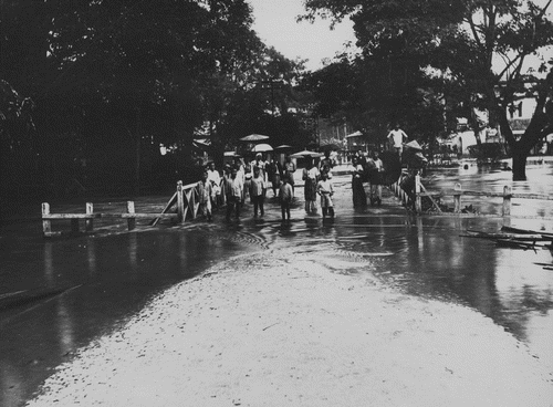
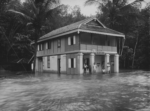
These stories, and the many others like them, while undoubtedly unpleasant and costly for those living through the experience, were nothing compared with the tragedy then unfolding outside of the city. The Great Flood of 1926 entailed a series of severe inundations that affected a large proportion of the rural peninsula north of Kuala Lumpur, including Selangor and Perak (FMS), with some of worst hit areas on the eastern seaboard in Pahang (FMS) and Kelantan (UNFMS). At a plantation estate in Kuala Reman, Kelantan, for instance, the floodwaters held such strength that “jungle trees brought down were stripped of all branches and bark, leaving bare trunks. The remains of human beings consisted of skeletons only, all flesh having been stripped off by abrasion.” Buildings and machinery were left coated in slime and the “dead bodies of tigers, bears, deer, pigs” were deposited across the estate. A private railway linking the plantation to mines at Sungei Lembing was partially washed away and trains had to be dug out of the mud afterward (CitationSingapore Free Press and Mercantile Advertiser, 24 January 1927, p. 7). Contemporary photographs document the effect of the floods in Parit, Perak. The following photographs were taken after the Perak River had risen more than 25 feet above its normal level (Figs. 1, 2).
Just north of Kuala Lumpur in the mining town of Kuala Kubu, Selangor, the DO reported how had been “continuous rain … from the night of 25 December to the forenoon of the 30th.” By the morning of 28 December, “Kuala Kubu was cut off from Rasa by both road and rail … I received the report of a case of death by drowning. At the hospital I saw the body of the deceased, a Chinese boy aged about 14 yr. He was said to have been drowned when attempting to remove driftwood from the river.” The DO noted that the access road to nearby Fraser's Hill—a popular spot for recreation and Europeans escaping the heat—had become impassable due to land slips and fallen trees. “In the evening the Hon'ble Mr Meadows Frost spoke to me by telephone from the Post Office” the DO reported. “He informed me that he and two other gentlemen had just come down from Fraser's Hill” saying that “there were about 30 slips on the road between Fraser's Hill and the Gap, the worst being about 150 yards in length.” The following morning, he “sent two police constables to the Gap with a letter to the Assistant Medical Officer there. I instructed him to get in touch with Mr St Barbo on Fraser's Hill and I asked to be notified of the number of European men, women and children and of Chinese, Malay and Indian servants and coolies who were there and what their requirements were. I pointed out that the road was open to wheeled traffic as far as Sungai Dua only and that all food would have to be carried from there to Fraser's Hill” (CitationSEL: SEC: 2/1927). In a somewhat ironic and sad history, the original Kuala Kubu mining settlement had been devastated by a flood before in 1883. Then, 33 residents had died, including the British DO Cecil Ranking.
At Pahang, the railway track running from Kuala Lipis to Kelantan was flooded under depths of 20 feet, the force of the waters at Manek Urai sweeping away two steel spans in the bridge over Sungai Lebir, each 250 foot in length and weighing 807 t (Fisher Citation1948, p. 1). At Pekan, Pahang, resident J. C. Sworder claimed that the flood height exceeded the previous record (set in 1924) by five feet. He described in a letter the enormous losses caused by the disaster, especially to the agricultural Malay population who “are suffering great hardships having had their houses, cattle and all they possess washed away.” He appealed to his correspondent for help to get in touch with the “chief government authority” in Singapore as, “since Christmas our telegraphic communications have been broken … and so far it is very uncertain if any letters have got through.” Sworder asked that a relief ship of rice be sent from Singapore for, without this aid, the Malay population would starve (CitationStraits Times, 14 January 1927, p. 13).
Flood relief was not provided systematically. Several state‐level initiatives were brought into immediate effect, but support and direction was largely provided by well‐meaning individuals and private associations. Many DOs, for example, were praised for their quick and tireless work which was seemingly performed as a result of their own resourcefulness as opposed to direct governmental orders. At Pekan, Sworder praised the efforts of their DO who had “most ably grappled with the serious situation and not spared himself” (CitationStraits Times, 14 January 1927, p. 13). Well‐to‐do boat owners placed their vessels and crews at the disposal of the government until the harbor master at Port Swettenham (Klang) could detail government launches to carry on the work. Six private launches were loaded onto trucks together with their crews within 6 h of a call to arms as a result of a joint effort of the harbor master, Railway and Customs Officials. The launches were then transported west by rail across the peninsula to where they were urgently needed in Pahang (CitationSEL:SEC 366/1927). In another instance of generosity, an unnamed 55‐year‐old gentleman offered to boat “up‐country on the Pahang river” to distribute food (CitationSingapore Free Press and Mercantile Advertiser, 20 January 1927, p. 7).
Relief funds were created from a combination of private and public donation. The Perak Relief Fund was one of the first, raising $63,000 Straits dollars by early January (CitationSingapore Free Press and Mercantile Advertiser, 13 January 1927, p. 7) and closing with a sum of $107.036 on the 22nd (CitationStraits Times, 26 January 1927, p. 11). On the 17 January, Chief Secretary Peel called an emergency meeting in Kuala Lumpur with the purpose of establishing a Malayan Flood Relief Fund to deal with the medium‐ to long‐term impact on people and property. The government paid an initial installment of $10,000 Straits dollars for the immediate provision of food. How the remaining funds were to be spent was subject for debate and a variety of initiatives were considered including free grants to help people rebuild their houses (CitationSingapore Free Press and Mercantile Advertiser, 20 January 1927, p. 7). The same was true of the Perak Flood Relief Fund where, by the end of January, discussions were still underway as to the best way of allocating monies. At the same time, the state authorities considered spending some of the fund on “carrying out of the much discussed and long promised flood prevention measures” (CitationStraits Times, 26 January 1927, p. 11).
Post‐Flood: Impact and Policy in the Short to Medium Term
Virtually, no aspect of life was left untouched as a result of the floods. The ecological, social, and political ramifications were both extensive and long term. In many of the flooded areas, padi crops were entirely ruined, leaving farmers with stark choices. At Tanjong Karang, Selangor, for instance, around 120 acres were devastated and, “the padi planters, due to a lack of seed and disheartened by the failure of the crop last year … decided not to plant” again in 1927 (CitationSEL:SEC: 4247/1927). Farmers found themselves relying once more on older agricultural methods. Swiddening—a type of “slash and burn” cultivation for temporary land use—had been a traditional practice in rural areas of Malaya. The loss of padi, combined with the destruction of riparian tree cover, in some cases the total destruction of virgin forest caused by the sheer intensity of floodwaters, fueled greater reliance on swiddening for subsistence (Kathirithamby‐Wells Citation2005, pp. 176–7). Local industry also experienced a shift in focus as a result of the floods. Before the mid‐1920s, rattan, for example, was used as the chief domestic building material. By 1925, the colonial forest department had taken an interest in this customary trade, hoping to expand the supply chain commercially. The Great Flood of 1926 however destroyed their rattan stockpiles and, with competition from other natural building materials, especially jelutong, the British had no choice but to refocus their energies. From that point on, the traditional rattan industry ceased to attract significant government investment and other materials, including the more sustainable jelutong, quickly overtook the market (Kathirithamby‐Wells Citation2005, p. 100).
On a rather different note, there was also a “very noticeable increase in the number of mosquitos” caused by pooling water making “life well‐nigh intolerable for many residents” in urban and rural areas (CitationStraits Times, 26 January 1927, p. 11). Malaria was a significant and ongoing concern for Malaya's health and sanitary authorities. The government had invested heavily in preventative measures subsequent to the recommendations of a Straits Settlements' Anti‐Malarial Committee appointed in 1911 (CitationRM I.E./53 B107). The early 1920s had seen significant progress in bringing down numbers of reported cases, so the resurgence in malarial cases in 1926 and 1927 was considered a great blow (Citation1998 Jarman, Vol. 8, p. 540, CitationRM I.E./57, 1923, B171).
The extensive loss of virgin forest during the 1926 floods had the long‐term consequence of exacerbating the intensity and frequency of future inundations. Devastated jungle was replaced by quick growing plants including creepers, vines, and rattans which did not perform the vital role of trees in protecting riverbanks and flood plains (Kathirithamby‐Wells Citation2005, p. 190). For example, the stripped banks of the Tembeling and Jelai rivers in 1926 intensified the process of riverine erosion and silting which, in turn, led to more severe flooding (Kathirithamby‐Wells Citation2005, pp. 6, 172). The irony is that the flood mitigation work carried out by the government actually magnified the problem. By way of example, a few months prior to the Great Flood, state engineers had enacted a relief plan for the Selangor River. After the flood, the acting State Engineer confessed that the plan of making “five shallow cuts, 200 feet wide through tanjongs … and the partial clearing of jungle along the banks of the river, had resulted in bringing the floods further West than ever before” (CitationPWD 86/27, p. 5). The cuts redirected water away from the river course which, although being the intended effect, the combination of heavy rainfall and high tide had overwhelmed the system and channeled water into a wider area than normal. A related problem was also the quality of the work being carried out. In April 1926, the state engineer had visited the worksite to make a progress report, but was disappointed to find that felled trees had been left to block the river and that earth removed during the process of deepening the river channel had simply been left on the banks (CitationSEL:SEC 52/26, pp. 1–2). In Province Wellesley, dams constructed to protect plantation land from flooding were blamed for redirecting water to flood previously unaffected areas (CitationRM I.E./59, 1925).
A letter from the Kuala Selangor District Planter's Association further highlighted the problems associated with contemporary mitigation works. In the early 1920s, the government had appointed C. E. Dupuis, a leading British engineer, as Advisor on Irrigation and Flood Prevention. Dupuis was critical of how human intervention had imbalanced the delicate ecosystem, thus exacerbating the impact of heavy rain:
Owing to the recent and rapid development of the country, roads in some cases have been constructed and towns built in unsuitable positions without adequate provision for floods but the real trouble … arises from the fact that in opening up the country, the natural conditions have been greatly changed and the flow of the rivers gravely affected. This has been caused mainly by tin mining and by the clearance of natural forests over large areas and their replacement by rubber or other plantations (CitationSingapore Free Press and Mercantile Advertiser, 21 April 1922, p. 4).
Dupuis also noted how the “conversion of dense tangled vegetation into orderly plantations with clean weeded ground surfaces has enormously increased the rapidity with which the water is discharged into adjacent rivers … and the escape of large quantities of course sand from the mine working into rivers has choked and destroyed their channel over considerable lengths” (CitationSingapore Free Press and Mercantile Advertiser, 21 April 1922, p. 4). His recommendation was the establishment of a new central department for flood mitigation. Their tasks would include the following: conducting research into river flows and behaviors, implementing mitigation schemes, and erecting new rain gauges for the systematic collection of rainfall observations. Dupuis produced a report setting out his recommendations for various schemes, including improvement works on the Selangor River and Sungai Buloh. The report was rejected however by the Selangor Planters who been requested to look over the plans in 1924. Their reasons were that despite Dupuis' reputation as a “leading British expert of the world in such matters … he was not thoroughly conversant with the difficulties involved.” In their opinion, Dupuis lacked basic knowledge of the local geography. His proposal to erect a bund on the river's south bank, they argued, would entirely neglect the issue of flooding on the north bank and might even exacerbate the problem for the estates situated there. The planters also claimed another major problem: the total indifference of the government in enacting any aspect of the report to date, good or bad. Regardless of the flaws in Dupuis' scheme, they stated, nothing at all had come as a result of his term as Advisor except neglect. Indeed, “the embankments” have “never been kept up and the channel is if anything in a worse condition than when the report was made” (CitationSEL:SEC 2430/26, pp. 1–2).
Critics landed the blame for the 1926 floods squarely at the British government's feet. The government responded by the end of 1927 with several new initiatives to compliment ongoing work and, in December 1927, they appointed a commission to investigate the state of the FMS' rivers. The commission recommended establishing a Rivers Advisory Board; diversion of Selangor's Sungai Choh, and relief work at Sungai Klang. Additionally, major works were proposed in the flood‐prone Kinta Valley, Perak, where mining works had severely damaged the environment (CitationM712/14‐15, p. 3). Over the next 10 yr, extensive work was undertaken on the country's river system. A significant advance was the appointment of a dedicated Drainage and Irrigation Department in 1933 which took responsibility for such matters from the PWD (Citation1998Jarman, Vol. 10, 1933, pp. 257–9). In addition to carrying out anti‐malarial works, a large part of their jurisdiction concerned the removal of sediment from rivers, restoring river channels destroyed by floods, strengthening and rebuilding of bunds, canal, and dam works (Citation1998Jarman, Vol. 11, 1938, pp. 392–3). Another impact of the floods was, indirectly, the major restructuring of the Malayan Meteorological Service. Proposed during 1927, it was perhaps inspired by Dupuis' recommendations for improving rainfall observations. An important component of the government's plan was to increase the number of manned meteorological registering stations across the peninsula, including in those rural states that had no consistent means for rainfall reporting. This was intended as “a preliminary to scientific investigation and a systematic study of the climate.” It would mean that large areas of the FMS and UNFMS would now be involved in a unified “foundation on which can be built a Meteorological Department capable of dealing with the needs of aviation, upper air research work, the distribution and exchange of information and weather predictions” (Citation1998Jarman, Vol. 9, 1927, p. 304). The improvements were completed by 1929 (Citation1998Jarman, Vol. 9: 1929, p. 355).
The 1926 Great Flood was a catalyst in hydraulic governance that was to irrevocably change the Malayan landscape, river system, and government policy. Dredging to deepen river courses, river deviation, the building of bunds, and jungle clearances were key to the plans. In the rural areas surrounding Malacca, for instance, the Rural Board invested in “clearing obstructions in the principle rivers … the Kesang River has been cleared in its lower reaches and work is going on upstream… the work done [will be of] benefit both to the padi lands and to the roads that were formally affected by flooding (CitationRM I.E./59, B187). By December 1927, the PWD were nearing completion of a massive project on the Selangor River that included clearing hundreds of acres of jungle on the lower reaches of the flood plain (CitationSEL:SEC 1096/27). In Ipoh, the government, acting on committee proposals, laid down long‐term plans to alter and straighten the course of the Kinta River” (Durand and Curtis Citation2014, p. 232). In Selangor, the same was proposed for Sungai Choh. By the late 1920s, a major scheme to deviate Sungai Klang with the aim of preventing floods in Kuala Lumpur was also underway. The scheme entailed straightening and enlarging the Klang River channel to enable flood waters to pass more rapidly, the creation of new overflow channels, and to use the dredged material to reclaim low‐lying land adjacent the river. This expensive scheme was integrated with sanitary improvements and new works, including the building of new roads and bridges (CitationPWD 99/31). In Penang, Singapore, and Malacca too, works were undertaken to raise roads, to build river walls, and to invest in land reclamation. In Singapore, for instance, the reconstruction of the Elgin Bridge was seen as an opportunity to widen the river and to build a defensive river wall (CitationRM I. E/62, B127). In rural areas, man‐made features of the landscape also changed. In southern Kelantan, for instance, the “roaring torrent” of the flood swollen Galas and Lebih rivers had entirely swept away a mile of riverine railway track in 1926. This forced a change in strategy whereby new track would be laid through hill tunnels adjacent to the river channel instead (CitationStraits Times, 15 August 1931, p. 11). In this way, floods played a direct role in changing Malaya's man‐made, as well as natural, landscape.
As Christian Pfister and others have argued, disasters have been shown to have a long‐term transformative, modernizing effect on societies, especially in regard to technologies and disaster responsiveness (Dyer Citation2000, Pfister Citation2009). There is much truth in this statement as it applies to the Malayan case, although it may not have been recognized at the time. For the people who lived through the 1926 flood and the regular annual inundations, governmental unresponsiveness and lack of progress would have been uppermost in their minds. In 1928, Sir George Maxwell, then former Chief Secretary of the FMS government gave a damning summary of hydraulic management in Malaya, arguing in regard to the FMS rivers that “deterioration was a slow but constant process from time immemorial until the advent of British protection … thereafter it increased rapidly and enormously as the result of deforestation, tin mining and ‘clean‐weeding’ which were inseparable from the general development of the country's resources” and that neglect on the part of the government had led to the poor state of the rivers by the 1920s (CitationM712/14‐15, pp. 4–5). Two years on, a question was raised by a member of the Straits Settlements Legislative Council which succinctly illustrated the mood of the day:
…amongst the many improvements being made … one does not find … improvement in the flooding. Floods are getting more frequent and the water takes longer to subside. Much inconvenience is caused and no doubt a great deal of damage is done by them. It seems to me that the water which concentrates in the town, or in the streets around the town, does not all fall there. It comes from outside districts. It comes, a great deal of it, from the Rural Board area, flows towards the sea, concentrates here, and is held up by the tide. The very excellence of our roads tends to confine the water, as their raised levels make it more difficult for it to get away. Even the roads themselves are frequently seen underwater. There are 3 or 4 authorities concerned in this matter … the Rural Board, the Municipality, and the PWD to a smaller extent; and the Improvement Trust, of course, ought to be consulted. One alone cannot deal with the problem and they have never, so far as I can find out, got together to consider a scheme of co‐operation … If we have bigger and better floods we ought to have bigger and better methods of dealing with them (CitationRM I.E./64, B49‐50).
These statements sum up the general ethos of complaint that can be gauged from the contemporary press. From the 1920s and into the 1930s, there was a significant increase in letters and articles critical of a perceived lack of governmental direction, a lack of integrated departmental cooperation, concern over a supposed escalation in flood frequency, and a perception that precipitation levels were increasing as a result of forest denudation (CitationRM I.E./65, B22).
It is clear that the mitigation strategies of late 1920s Malaya were inspired by the home‐grown Great Flood of 1926. It is less known however that the “terrible lesson of the Mississippi, where the failure to control the river has been due, to a great extent, to want of a Federal Control” (CitationM712/14‐15, p. 4) was also a dominant narrative in contemporary politics. In Malaya, avoiding a disaster of the scale of the 1927 Mississippi river flood translated into questions concerning the lack of a dedicated governmental body to deal with flood mitigation. In particular, it was felt that the PWD alone was unable to cope with the ever‐escalating problem of flood prevention. Nevertheless, despite some good intentions, the recurring specter of recession (1919–22, 1929–32) and then the Second World War (1939–45) served to delay or suspend many non‐essential works. Thus, while there was some positive improvement in flood defenses, the lack of consistency due to internal and external factors hampered the implementation of a really effective strategy.
Conclusions
This case study shows that although La Niña caused exceptionally heavy rains in 1926, a combination of man‐made environmental change and poor (often conflicting) hydraulic management were to blame for the severity of the inundation. The transformation of land use, especially commercial plantation and industrial mining, eroded natural forms of flood defense through deforestation and clogged rivers with waste products. The 1926 floods exacerbated the problems, by devastating agricultural lands, destroying riparian virgin forest, and in some cases, forcing a shift in commercially produced crops, such as rattan to jelutong. The British government's long‐term strategies toward flood mitigation also resulted in changes to the rural and urban landscape through a policy of “cutting” rivers, clearing riverine jungle, and straightening river courses. Although the mid‐1920s floods acted as a catalyst toward expanding and developing flood prevention and management, this was not a linear transition toward modernization. The historians' long view enables us to analyze this claim in greater detail. Many of the government's mitigation projects reconstituted the mistakes of the past or, were simply ineffective in coping with extreme weather. We see this, for example, in 1954 when extant defenses—despite improvement since the 1920s—proved woefully inadequate in the face of heavy rains connected to that year's La Niña.
Socially and politically, floods continued to be a serious problem for the British government. Mitigation schemes were costly to enact and to maintain, and the stream of complaints from within government and the municipal councils, as well as from the public, reveals that they were also not always effective. The problem of flooding was, and will continue to be, a serious problem in South‐East Asia, exacerbated by anthropogenic climate change and rising sea levels (Douglass Citation2013, p. 4, Miller and Douglass Citation2016, pp. 1–2). However, by looking at how past governments dealt with disasters, and by assessing the strengths and weaknesses of their strategies, it is possible to learn from past mistakes and successes.
Acknowledgments
The project benefited from a Singapore Ministry of Education Academic Research Fund Tier 2 grant entitled “Governing Compound Disasters in Urbanising Asia” (MOE2014‐T2‐1‐017).
Related Research Data
Literature Cited
- Allan, R. J., and R. D. D'arrigo. 1999. Persistent' ENSO sequences: How unusual was the 1990–1995 El Niño? Holocene 9:101–118.
- Bankoff, G., G. Frerks, and D. Hilhorst, editors. 2004. Mapping vulnerability: disasters, development & people. Earthscan, Oxon, UK.
- Barry, J. M. 1997. Rising tide: the Great Mississippi flood of 1927 and how it changed America. Simon and Schuster, New York, New York, USA.
- Brádzil, R., Z. W. Kundzewicz, and G. Benito. 2006. Historical hydrology for studying flood risk in Europe. Hydrological Sciences 51:739–764.
- Coggins, A. R. 2011. Tennessee tragedies: natural, technological, and societal disasters in the volunteer state. University of Tennessee State Press, Knoxville, Tennessee, USA.
- Cook, E. R.. 2000. Nino 3 Index Reconstruction. International Tree‐Ring Data Bank. IGBP PAGES/World Data Center‐A for Paleoclimatology Data Contribution Series #2000‐052. ftp://ftp.ncdc.noaa.gov/pub/data/paleo/treering/reconstructions/nino3_recon.txt
- Corlett, R. T. 1995. Introduction. Pages 7–10 in S. C. Chin, R. T. Corlett, Y. C. Wee, and S. Y. Geh, editors. Rain forest in the city: Bukit Timah Nature Reserve, Singapore. Gardens Bulletin, Singapore, 3. National Parks Board, Singapore, Singapore.
- Davis, M. 2001. Late Victorian Holocausts: El Niño famines and the making of the third world. Verso, London, UK and New York, New York, USA.
- Douglass, M. 2013. The Urban Transition of Environmental Disaster Governance in Asia. ARI Working Paper Series, 210. National University of Singapore, Singapore, Singapore.
- D'souza, R. 2006. Drowned and dammed: colonial capitalism and food control in Eastern India. Oxford University Press, Oxford, UK.
- Durand, F., and R. Curtis. 2014. Maps of Malaysia and Borneo: discovery, statehood and progress. Editions Didier Millet Sdn Bhd, Kuala Lumpur, Malaysia.
- Dyer, C. L. 2000. The phoenix effect in post‐disaster recovery:? An analysis of the economic development administration's culture of response after Hurricane Andrew. Pages 278–300 in S. M. Hoffman and A. Oliver‐smith, editors. The angry earth: disaster in anthropological perspective. Routledge, New York, New York, USA.
- Fisher, C. A. 1948. The railway geography of British Malaya. Scottish Geographical Magazine 64:123–136.
- Gergis, J. et al., 2006. Reconstructing El Niño‐Southern Oscillation (ENSO) from high‐resolution palaeoarchives. Journal of Quarternary Science 21:707–722.
- Grove, R. 1995. Green imperialism: colonial expansion, tropical garden Edens and the origins of environmentalism, 1600–1860. Cambridge University Press, Cambridge, UK.
- Hoops, A. L., Annual Report on the Medical Department, Straits Settlements, 1926 (Singapore, 1927). All medical reports are courtesy of the Wellcome Library, London.
- Jarman, R. L. 1998. Annual Reports of the Straits Settlements, 1855–1941, Vol. 8., 1922–26. Archive Editions, Slough, UK.
- Jarman, R. L. 1998. Annual Reports of the Straits Settlements, 1855–1941, Vol. 9., 1927–31. Archive Editions, Slough, UK.
- Jarman, R. L. 1998. Annual Reports of the Straits Settlements, 1855–1941, Vol. 10., 1932–36. Archive Editions, Slough, UK.
- Jarman, R. L. 1998. Annual Reports of the Straits Settlements, 1855–1941, Vol. 11., 1936–41. Archive Editions, Slough, UK.
- Kathirithamby‐wells, J. 2005. Nature and nation: forests and development in peninsular Malaysia. National University of Singapore Press, Singapore, Singapore.
- Kong, L., and B. Yeoh. 1996. Social constructions of nature in Urban Singapore. Southeast Asian Studies 34:402–415.
- Lim, G. T. 1977. Peasants and the agricultural economy in Colonial Malaya, 1874–1941. Oxford University Press, Oxford, UK.
- Logan, J. R. 1848. The probable effects on the climate of Pinang of the continued destruction of its hill jungles. Journal of the Indian Archipelago and Eastern Asia 2:534–536.
- Matthews, A. S. 2011. Instituting nature: authority, expertise, and power in Mexican forests. MIT Press, Cambridge, Massachusetts, USA.
- Mauch, C., and C. Pfister. 2009. Natural disasters, cultural responses: case studies toward a global environmental history. Lexington Books, Lanham, Maryland, USA.
- Miller, M., and M. Douglass. 2016. Disaster governance in urbanising Asia. Springer, Singapore, Singapore.
- National Archives of Malaysia (hereafter NAM), SEL:SEC 2430/26. Letter from the Kuala Selangor District Planters' Association, 31 March 1926.
- NAM, SEL:SEC 52/26. Report on Selangor River Flood Relief Work, April 1926.
- NAM, SEL:SEC 2/1927. Flood at Kuala Kubu December 1926.
- NAM, SEL:SEC 366/1927. Motor boats and crews placed at the disposal of Government.
- NAM, SEL:SEC 4247/1927. Supply of padi seeds to Malay padi planters whose crops were destroyed by the floods, at Tanjong Karang.
- NAM, SEL:SEC 1096/27. Selangor River Flood Channels: Monthly Progress Reports 1927, 2 February 1928.
- NAM, PWD 86/27. Report on the Floods in the Kuala Selangor District by the Acting State Engineer, 7 February 1927.
- NAM, PWD 99/31. Amelioration of Floods, Kuala Lumpur, 14 January 1931.
- National Archives of Singapore (hereafter NAS), M712/14‐15, ff. 84‐5. Letter from the American Consulate at Singapore 30 August 1928 to the Secretary of State, Washington, D.C.
- NAS, RM I.E./53. Straits Settlements Legislative Proceedings, 1911.
- NAS, RM I.E./57. Straits Settlements Legislative Proceedings, 1923.
- NAS, RM I.E./59. Straits Settlements Legislative Proceedings, 1925.
- NAS, RM I.E./62. Straits Settlements Legislative Proceedings, 1928.
- NAS, RM I.E./64. Straits Settlements Legislative Proceedings, 1930.
- NAS, RM I.E./65. Straits Settlements Legislative Proceedings, 1931.
- NIWA, Historic Weather Event Catalogue June‐July 1925: hwe.niwa.co.nz/event/June‐July_1925_New_Zealand_Floods/pdf
- Pfister, C. 2009. Learning from nature‐induced disasters: theoretical considerations and case studies from Western Europe. Pages 17–40 in C. Mauch and C. Pfister, editors. Natural disasters, cultural responses: case studies toward a global environmental history. Lexington Books, Lanham, Maryland, USA.
- Qian, C., Z. Wu, C. Fu, and D. Wang. 2011. On Changing El Niño: a view from time‐varying annual cycle, interannual variability, and mean state. Journal of Climate 24:6486–6500.
- Quinn, W. H. 1992. A study of Southern Oscillation‐related climatic activity for ad 622–1900 incorporating Nile River flood data. Pages 119–149 in H. F. Diaz, and V. Markgraf, editors. El Ninõ: historical and paleoclimatic aspects of the Southern Oscillation. Cambridge University Press, Cambridge.
- Quinn, W. H., and V. T. Neal. 1992. The historical record of El Nino events. Pages 623–648 in R. S. Bradley, and P. D. Jones, editors. Climate since A.D. 1500, Revised Edn. 1995. Routledge, London, UK.
- RCS, BAM 3/52&53. Photographs from the Parit Floods at Perak, Malaysia, 1926. Courtesy of the Royal Commonwealth Society, British Association of Malaysia and Singapore, Cambridge University Library Archive.
- Rohr, C. 2013. Floods of the upper Danube and its tributaries and their impact on urban economies c. 1350–1600: the examples of the towns of Krems/Stein and Wels (Austria). Environment and History 19:133–148.
- Schenk, G. J. 2007. Historical disaster research. State of research, concepts, methods and case studies. Historical Social Research 32:9–31.
- St Andrew's Church. http://standrewschurch.org.my/about-us/history/1924-1960-times-of-testing/
- Tan, K. W. 1999. Keeping botanical gardens relevant—the Singapore botanic gardens experience. BGCNews 3:www.bgci.org/index.php?option=com_article&id=0121&print=1
- The Straits Times, 24 April 1886.
- The Straits Times, 30 December 1926.
- The Straits Times, 5 January 1927.
- The Straits Times, 14 January 1927.
- The Straits Times, 26 January 1927.
- The Straits Times, 15 August 1931.
- The Singapore Free Press and Mercantile Advertiser, 21 April 1922.
- The Singapore Free Press and Mercantile Advertiser, 13 January 1927.
- The Singapore Free Press and Mercantile Advertiser, 24 January 1927.
- The Singapore Free Press and Mercantile Advertiser, 20 January 1927.