Abstract
Tannur dam, sited about 150 km south of Amman on Wadi Al Hasa with a reservoir capacity of 17 × 106 m3, forms part of the Southern Ghors project for water supply and irrigation in the Jordan valley. Values obtained for plastic limit (PL) ranged from 9.8 to 30.3 mass %, liquid limit (LL) 20–42 mass % and plasticity index (PI) 7.3–16.3 mass % for alluvium materials, while values obtained for PL ranged from 10 to 32 mass %, LL 28–58 mass % and PI 12–43 mass % for landslide materials. PSD analysis shows that the materials at the dam site falls into the sandy to clayey silt grain size range. XRD analysis revealed that the landslide materials are composed of smectite as major component with minor amounts of calcite and quartz, while the alluvium materials are mostly composed of quartz, calcite and smectite. Based on the plasticity characteristics, the alluvium materials are slightly to moderately plastic, while the landslide materials are classified as moderate to high plasticity. Accordingly, it is evident that the landslide materials reflect high swell potential due to the presence of considerable amount of expansive clays (smectite).
1 Introduction
Jordan is part of arid and semi-arid region of the Middle East, where its natural resources are scarce. Water is precious and vital to maintaining the socio-economic development of Jordan. Comprehensive planning is foreseeable and must be applied in an equitable way, taking into consideration various water rights and priority needs for competing development sectors such as domestic, agriculture, industry and tourism.
Jordan depends to a large extent on dams to store water from surface flow, to be used later for irrigation, domestic supply, industrial supply and groundwater recharge. Most of the constructed and proposed dams in the country are of embankment type because certain geological features and economy favors that kind of dam. Tannur dam is part of a water supply and irrigation project serving farmland in the Southern Ghors area in Jordan, which also includes Wala and Mujib dams as well as a conveyance system toward the Dead Sea.
Tannur dam, located 150 km south of the Jordanian capital Amman, The dam site is located in a narrow V-shaped valley with abutment sides rising at about 30° for up to 100 m above Wadi bed level ( and ). It is located in a semi-arid region of central Jordan at an elevation of 400 m., between plateau at level 1000–1100 m and the Dead Sea at level 400 m, with rainfall and runoff only occurring in the winter months between October and April. Annual rainfall is low, generally varying between 63 and 115 mm on the catchment basin. Temperatures can vary from up to 43 °C in summer to less than 5 °C, and occasionally freezing, in the winter. The relative humidity is low, between 40 and 65%.
Fig. 1 Location map of the Tannur dam site.
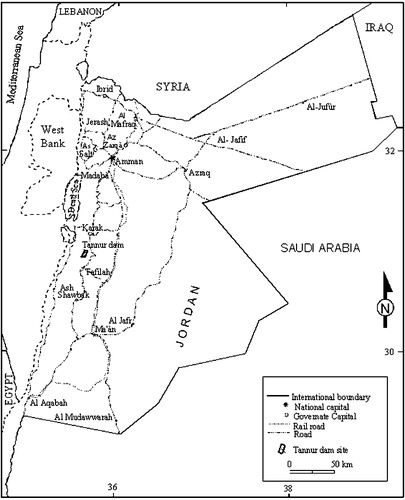
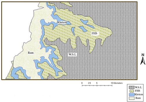
Fig. 2 Geological map of the dam and reservoir sites. W.S.L: Wadi Es Sir Limestone; FHS: Fuheis, Hummar and Shueib Formation.
Tannur dam is 69 m height, 230 m length and 12 m width at its crest roller compacted concrete (RCC) gravity dam, which impounds a reservoir of 17 × 106 m3 on Wadi Al Hasa, one of the major wadis (watercourses) discharging to the southern Dead Sea area [Citation1]. This type of dam was proposed by Mott Macdonald Company, who advised the Ministry of Water and Irrigation and supervised the construction of such a dam at the southern part of the Dead Sea [Citation2].
The filed investigations included geological mapping of the area, field investigations for the 17 continuous sample borings. Whereas, the laboratory investigations included the measurements of the physical and geotechnical properties of the samples such as grain size distribution and Atterberg limits of undisturbed samples of typical soil deposits at the site.
Field and laboratory data were analyzed and then utilized to describe and evaluate the engineering characteristics of the soil, alluvium and landslide materials at the dam site and reservoir area, which affect the stability of the dam abutments. Stability condition was evaluated at the dam site.
2 Geology of the dam site
The geology of the study area is dominated by a sedimentary succession ranging in age from Upper Cambrian to Quaternary, with exposures of igneous rocks belonging to the Late Paleozoic and Early Mesozoic (). The area of the dam site and reservoir is underlain Kurnub Sandstone of Lower Cretaceous, which overlies unconformably the Umm Ishrin Sandstone of Upper Cambrian age. The Tannur dam is situated a few kilometers west of Wadi Al Hasa Bridge. The site consists entirely of Upper Cretaceous strata. The whole site is occupied by an anticline plunging northwards. The following rock units crop out in the dam site and reservoir area (): (1) Top Na’ur Formation, these rocks are massive, fossiliferous, cliff-forming strata. Accordingly, these are considered excellent foundations; (2) Marl–Shale Formation, these formations overlies the top Na’ur Formation. These rocks are not a good foundation, but can be tolerated when present in small thicknesses; (3) Limestone Formation, this is again a good rock, which makes the foundation of the shoulders of the dam in the left abutment; (4) thick sequence of Marl–Clay–Gypsum, this is the worst part of the sequence. Landslides have taken place on certain parts of this horizon. Fortunately, this horizon is higher than the topmost part of the dam except for few meters in the left shoulder. In the right abutment, the same rock units are present, but because of a higher dip of strata the situation is much better than the left abutment except for the two clay beds, which have been treated to ensure the safe stability of the dam. The dam area was investigated by local and international consulting engineering firms [Citation2,Citation3].
Following is a brief description of these geologic formations in the Tannur Dam site and reservoir area ().
2.1 Umm Ishrin Sandstone (UM)
This is the oldest formation found in the dam site and its surroundings areas. It is exposed at the base of cliffs some 500 m downstream of the dam site and comprised light brown medium grained sandstone. Its age ranged from Middle to Late Cambrian or possibly Early Ordovician [Citation4].
2.2 Kurnub Sandstone (KS)
This formation (Lower Cretaceous) [Citation4–Citation6] and overlies with a distinct hiatus and slight angular unconformity the Umm Ishrin sandstone, occurring approximately 30 m above bed level in the cliffs downstream of the dam site and at approximately 415 m above sea level immediately to the west of the basalt plug on the northern rim of the reservoir area. The massive white medium grained sandstone and the overlying varicolored sandstone is exposed in the study area. Both lithostratigraphic units are apparently of continental origin; only the uppermost position of the varicolored sandstone, which is developed more marly and shale, show some indications of marine depositional environment ().
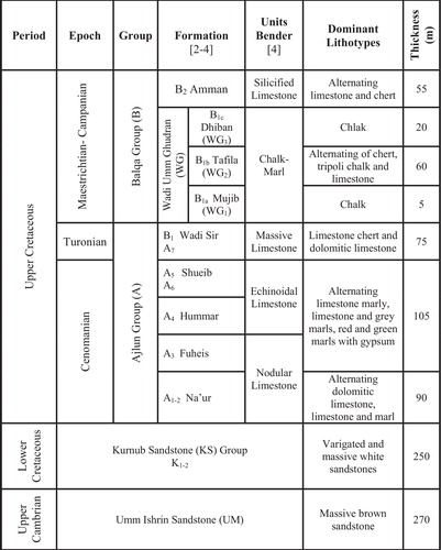
2.3 Na’ur Limestone (A1-2)
This formation (Late Albian to Early Cenomanian) crop out in the beds of wadis running into Wadi Al Hasa on the southern rim of the reservoir area and also in the siq of Wadi Al Hasa some 1000 m upstream of the dam site [Citation4]. It represents the first major transgressive phase and advance of Tethys Ocean across the alluvial (Kurnub) plain. The formation consists of shelly limestone, dolomitic limestone, dolomite and marl. Sandstone with variable sideritic or limonitic cements and gluaconite peloids are commonly interbedded with siltstone or marl, which is transitional with the underlying Kurnub sandstone [Citation7].
2.4 Fuheis (A3), Hummar (A4) and Shueib (A5 and A6) Formation [FHS]
This unit underlies the majority of the dam site and reservoir area. Its equivalent to A3-6 unit [Citation2,Citation3,Citation7] and correlative with the upper part of the nodular limestone member [Citation4]. It ranges in age from Late Cenomanian to Early Turonian. This unit consists of greenish-gray marl with thin beds and nodules of micritic limestone, calcareous siltstone, yellow marl and green red mudstone with gypsum interbedded with harder beds of shelly micritic and dolomitic limestone. The thickness of this unit in the study area is about 20–30 m.
A basal yellowish green marl of some 5 m thickness is outcrops at the base of cliffs formed by wadis running in to the Wadi Al Hasa at the southern rim of the reservoir area. This unit is overlain by about 10–15 m thick of interbedded buff marly and about 0.5–1 m thick argillaceous limestone in beds, observed on the southern rim of the reservoir area approximately 400 m upstream of the dam site [Citation7]. The clay and marl sequence is overlain by a sequence of buff interbedded marly, argillaceous and siliceous limestones of about 40 m thickness which from the abutments at the dam site.
2.5 Wadi Es Sir Limestone [W.S.L (A7-B1)]
This formation (Turonian age) represents the topmost of the Ajlun group. It is equivalent to the massive limestone unit and the sandy limestone unit [Citation4]. The formation overlies the limestone sequences at the top of the FHS at approximately 370 m above sea level at the dam site and observed at Wadi bed level approximately 200 m downstream. It consists of well-bedded massive limestone, dolomitic limestone and dolomite, sandy limestone and marls; beds of chert nodules are common in the middle and upper parts.
2.6 Amman Silicified Limestone Formation (B2)
This formation (alternation of limestone and chert) represents the base of the Belqa’ group and appears only in the northeastern of dam site. The age was considered as a Santonian-Campanian [Citation4]. A dark gray, thick-bedded, autobrecciated chert which marks the base is interbedded with microcrystalline, variably phosphatic limestone. The formation is about 55 m thick.
2.7 Basalt
A plug of massive basalt outcrops approximately 900 m upstream of the dam site on the northern rim of the reservoir area. The material is generally black, compact and fine grained and exhibits vertical columnar jointing. The slopes to the south of the plug, below 400 m above sea level are covered with a basalt screed comprising boulders up to 1 m3 in size.
2.8 Quaternary sediments
Quaternary sediments in this study are represented by colluvial, Wadi sediments and fluviatiale gravels. This formation is subdivided into three subunits:
| - | Colluvial deposits: Colluvial deposits representing landslides dominate the northern rim of the reservoir area and the area of the southern rim immediately upstream of the dam area. The material has been proved to a maximum depth of 20 m and generally comprises angular limestone and marl/gypsum gravel and cobbles with a buff sandy clayey silt matrix. | ||||
| - | Recent alluvium. Terraces of recent alluvium occur on either side of the Wadi Al Hasa both in the reservoir area downstream of the dam site. The material forms near vertical banks up to 4 m high above Wadi bed level and comprises generally rounded gravel and cobbles with a buff sandy clayey silt matrix. The gravel and cobbles are of similar lithology to those found in the Wadi gravel. | ||||
| - | Wadi gravel. The bed of the Wadi Al Hasa downstream of the siq in the Na’ur limestone comprises Wadi gravel up to 70 m wide and proved to a maximum thickness of 15 m on the dam site. Thinner deposits of Wadi gravel are also encountered in the wadis of the southern rim of the reservoir area. The Wadi gravel generally comprises cobbles and boulders with a silty sand matrix. The gravel, cobbles and boulders are of mixed origin and comprise most of the strata occurring above the FHS Formation in the stratigraphic column, namely limestones, cherts and basalts and also some sandstone derived from the Umm Ishrin and Kurnub sandstones. | ||||
2.9 Structures
The general dip of the beds is a downstream dip of approximately 20°. The main structure affecting the area is the Wadi Al Hasa fault which strikes WNW in the dam region and lies 500 m to the N-E of the dam site. Wadi Al Hasa fault strikes generally E-W to form the Dead Sea fault, which is about 23 km west of the dam site. To the east it dies away into a series on minor faults emerge with the Karak-Faiha fault [Citation6]. On the west side of the basalt plug Fuheis, Hummar, Shueib (FHS) marl is found faulted against Kurnub sandstone with N-S strike [Citation4].
3 Field and laboratory investigation techniques
An experimental investigation was carried out to determine the index properties of the alluvium, landslide materials and gravels at Tannur dam site and the swelling characteristics behavior of the landslide and alluvium samples. Seventeen representative samples (cylindrical type) were obtained from depths of between 0.5 and 2 m and collected from the dam site and reservoir area. A set of experiments designed to characterize the soil samples. The set included: grain size analysis, mineralogical composition, Atterberg limits (liquid and plastic limits), specific gravity, and water content (these samples were subjected to various laboratory tests including sample preparation, grain size analysis, mineralogical composition and physical properties).
Mineralogical, physical and geotechnical characteristics of the studied samples were determined in the Geotechnical Laboratory of Natural Resources Authority (NRA), Jordan and in the Concrete and Material Laboratory of the Leibniz Hannover University, Germany.
Mineralogical study of the examined samples was investigated using powder X-ray diffraction (XRD), performed on a Philips X Pert-Pro PW 1710 diffractometer using Ni filtered CuKα radiation at 40 kV and 40 mA. Runs were carried out with a step width of 0.03° 2θ and a measuring time of 1 s per step and obtained from 2 to 70° 2θ.
Grain size analysis of the studied samples was carried out by wet sieving and hydrometer. The distribution of particle sizes larger than 75 μm was determined by wet sieving, while the particle size analysis passing 75 μm sieve was undertaken by a sedimentation process, using a hydrometer to secure the necessary data.
These tests were performed in accordance with ASTM D422-63, D854-00, and D4318-05 [Citation8–Citation11].
4 Results and discussion
4.1 Mineral composition
The XRD results () of the examined samples indicate that the alluvium and landslide materials were composed of smectite (montmorillonite) as major component with minor amounts of calcite and quartz, while the alluvium materials are mostly composed of quartz, calcite and smectite (montmorillonite). Gypsum was identified in minor amounts in landslide materials, whereas it is detected as traces in alluvium materials. Dolomite is absence in alluvium materials, whereas it is present as traces in the landslide materials.
Table 1 XRD analysis of the studied samples from the Tannur dam site.
4.2 Grain size distribution
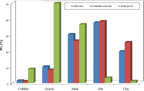
Results of grain size analysis (grading analysis) of the studied samples are given in . represents the grain size distribution of clay, silt, sand and gravel fractions. illustrated the grain size distribution of clay, silt, sand and gravel fractions of the landslide, alluvium and Wadi gravel materials.
Table 2 The grain size analysis of clay, silt, sand and gravel fractions of the investigated samples from dam site and reservoir area.
Fig. 4 Grain size distribution of the studied samples from the dam site and reservoir area.
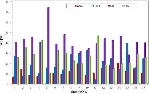
indicates that the both alluvium and landslide materials are characterized by sandy to clayey silt texture.
Fig. 5 Grain size distribution of the materials at the dam site.
4.3 Physical and geotechnical investigations of the soil materials at dam site
Physical and geotechnical properties for the alluvium and landslide materials are summarized in . Despite the close similarity of their general characteristics, there are some slight differences in index properties, although both soils are classified as sandy to clayey silt texture. The alluvium materials consist of ∼10% gravel, 30% sand, ∼38% silt and ∼20% clay. The more clayey landslide materials consist of ∼8% gravel, 26.5% sand, ∼39% silt and 25.5% clay. All plasticity values of the alluvium and landslide materials are plotted on the Casagrande plasticity chart as illustrated in and , respectively.
Table 3 Physical and geotechnical characteristics of the collected materials from the Tannur dam site.
Fig. 6 Plasticity characteristics of the alluvium materials, Tannur dam site.
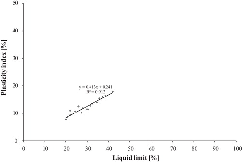
Fig. 7 Plasticity characteristics of the landslide materials, Tannur dam site.
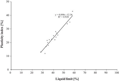
The investigations found that the alluvium and landslide materials have the potential to swell ( and ). The plasticity index values increase with the decrease of particle size (increase in the total surface area). The obtained Atterberg limit values and the swelling properties of the alluvium and landslide materials reflect the presence of expansive smectite clay. and indicated that liquid limits for alluvium materials varied from 20 to 42% with an average of 28.32% and below the 50% liquid limit on the Casagrande plasticity chart, while for the landslide materials, they range from 28 to 58% with an average of 40.60% and above the 50% liquid limit. Indicating that, alluvium materials are slightly to moderately plastic (the plasticity increasing with increases in clay content), while the landslide materials are moderately to highly plastic and expected to have moderately to high swell potential when compared to the criteria for identifying swell potential, such as the one proposed by Dakshanamanthy and Raman [Citation12] and shown in and .
The data in clearly shows that landslide materials have high swell potential; due to the presence of significant amounts of expansive clays (smectite) content. The geology of the upper part of the left abutment is somewhat more complex than that of the dam site as a whole. This may be explained by the fact that, as shown by X-ray analysis, its composition is dominated by the montmorillonite (smectite clays). Montmorillonite clay has a very high swelling potential than other clays. An important feature is the existence of expansive clays strata in the middle of the FHS unit (which makes the foundation of the left abutment) plays a major role in controlling the stability of the Tannur dam, especially when water is introduced into the foundation and accumulates within the clayey material.
The landslide material represents sliding of more competent material on the weaker marl and clay strata (expansive clays) in the middle of the FHS member with high swelling potential, consolidation and low shear strength may result in the damage of dam structure. The landslide lobes from slopes of up to 45° and are generally stable in dry conditions. Instability can be seen, however, in the material directly upstream of the left abutment, where the stream has undercut the toe of the slipped mass. Expansive clays (smectite) strata may absorb a significant quantity of water that results in the reduction of shear strength of the foundation bedrock and is characterized by their ability to expand (swell), or shrink when their water content increase or decrease [Citation13,Citation14]. The full understanding of the behavior of expansive clays will help in minimizing number of these engineering problems. Depending on the geotechnical investigations, soil stabilization methods are recommended as a treatment technique to overcome the effect of underneath swelling/shrinkage of the expansive clays in the upper part of left abutment at dam site. At present, the method of cement grouting is highly prevalent in a number of branches of structural engineering; and in foundation engineering for the reinforcement of existing foundations beneath buildings and structures as well for strengthening the soils in their beds [Citation15,Citation16].
5 Conclusions
Considering the results obtained from the performed tests, the following can be concluded:
| - | The results obtained from the geological and engineering investigations have provided useful information regarding the physical and engineering properties of the surface soil samples as well as alluvium and landslide materials at dam site and reservoir area. | ||||
| - | The Atterberg limits, grain size characteristic and mineralogical composition indicate that both alluvium and landslide materials at dam site are quiet similar, although there are some differences composition that explain the plasticity difference. These both materials can be classified as sandy to clayey silt texture. The alluvium materials are slightly to moderately plastic, while the landslide materials can be classified as moderate to high plasticity, due to the presence of considerable amount of expansive clays (smectite). | ||||
| - | Stabilization measures for the upper left abutment were required to prevent any sliding along the clay layer. General consolidation grouting of the abutment should be carried out to ensure the integral action of the rock mass above the clay layer. | ||||
| - | Soil stabilization methods are recommended to overcome the effect of underneath swelling of the expansive clays in the upper part of left abutment at Tannur dam site. | ||||
Acknowledgement
The authors gratefully acknowledge the funding of this study by Tafila Technical University. Special thanks are extended to the Ministry of Water and Irrigation (Jordan Valley Authority and the Directorate of Dams) for offering the required information for this study, as well as two anonymous reviewers for constructive comments on the manuscript.
Notes
Peer review under responsibility of Taibah University
Related Research Data
References
- C.M.WagnerKh.HazaiymaDesign approach to geological problems encountered at Tannur DamA.I.Husein MalkawiM.AuirgerTh.StroblProceeding of the 2002 International Conference on Roller Compacted Concrete Dam Construction in Middle East, April 7th–10th2002Jordan University of Science and TechnologyIrbid, Jordan201212
- Mott.MacDonaldConsultancy services for engineering supervision of construction of Tannur DamDesign Review Report, March1999
- H. Humphreys and Partners, The study and design of Tannur Dam. Draft final report, vol. I. Site investigation. Internal report of the Jordan Valley Authority of Jordan, Amman, 1995.
- F.BenderGeology of Jordan1974Gebrueder BorntraeerBerlin196
- M.GougazehGeology, mineralogy, geochemistry and evaluation of kaolinite and silica sand of white sandstone in south Jordan for industrial applications1991Yarmouk UniversityIrbid-Jordan261 (M.Sc. Thesis)
- M.GougazehJ.-Ch.BuhlGeochemical and mineralogical characterization of the Jabal Al-Harad kaolin deposit, southern Jordan for its possible utilizationClay Mineralsvol. 452010GeoScience World, The Mineralogical SocietyUK281294
- J.H.PowellStratigraphy and sedimentation of the Phanerozoic rocks in central and south Jordan, part A & B. Natural Resources Authority, Geology DirectorateGeological Mapping Division Bulletin111989
- American Society for Testing and Materials, Standard Test Method for Specific Gravity of Soils. ASTM Designation D854-00, 2000.
- American Society for Testing and Materials, Standard Practice for Classification of Soils for Engineering Purposes (Unified Soil Classification System). ASTM Designation D2487-00, 2000.
- American Society for Testing and MaterialsStandard Test Method for Particle-Size Analysis of Soils2002 ASTM Designation D422-63
- American Society for Testing and MaterialsStandard Test Methods for Liquid Limit, Plastic Limit, and Plasticity Index of Soils2005 ASTM Designation D4318-05
- V.DakshanamanthyV.RamanA simple method of identifying an expansive soil. Soils and FoundationsJapanese Society of Soil Mechanics and Foundation Engineering13197397104
- N.HudymaB.Burcin AvarChanges in swell behavior of expansive clay soils from dilution with sandEnvironmental and Engineering Geo-Science1222006137145
- H.B.DyeS.L.HoustonB.D.WelfertInfluence of unsaturated soil properties uncertainty on moisture floe modelingGeotechnical and Geological Engineering292013161169 2011
- C.LucianGeotechnical aspects of buildings on expansive soils in Kibaha, Tanzania: Preliminary Study2011Department of Civil and Architectural Engineering, Royal Institute of TechnologyStockholm, Sweden (Licentiate Thesis)
- R.C.EwingFoundation repairs due to expansive soils: Eudora Welty house, Jackson, MississippiJournal of Performance of Constructed Facilities25120115055