
Highlights
| • | Shifting cultivation must be viewed as a “tool kit” with which farmers improvise. | ||||
| • | Crop-fallow time ratios are not good indicators of shifting cultivation sustainability. | ||||
| • | Farmers may adopt permanent agriculture when shifting cultivation is still sustainable. | ||||
| • | The demise of shifting cultivation can be temporary. | ||||
| • | Interactions between technology, environment and society are dynamic. | ||||
Abstract
In the understanding of the relationship between forests, agriculture and landscape change, the impact of shifting cultivation has been a major topic, but also a major point of debate. The very definition of the concept is under discussion, starting with the importance given to the length of the fallow period and ending with the question of defining it as a system, many systems or a “tool kit”. Can we consider the length of the fallow period or the crop-fallow time ratios as good indicators for the sustainability of shifting cultivation, and is permanent agriculture only adopted beyond certain thresholds? These are some of the topics this article aims to address through a case study conducted in Eastern Guinea-Bissau. In this social and agro-ecological relatively homogeneous region, while shifting cultivation of peanuts for export and cereals for home consumption caused major deforestation and soil degradation during colonial times, today these agricultural practices are being substituted by an expanding cashew nuts agricultural frontier.
1 Introduction
The demise of shifting cultivation has been generally presented as inevitable under conditions of population increase causing the shortening of fallow lengths [Citatione.g.,1]. Following Ruthenberg’s [Citation2] work “Farming systems in the tropics”, the concept of shifting cultivation has been frequently associated to short cropping periods and long fallows under slash-and-burn agricultural practices [e.g.,Citation3,Citation4]. Other scholars, however, include all (short or long) fallow systems that use the felling of trees, the burning of the slashed vegetation to increase soil fertility, and the shifting of fields [e.g.,Citation3,Citation5,Citation6,Citation7,Citation8]. For these scholars, shifting cultivation, swidden agriculture and slash-and-burn cultivation are synonyms (idem).
More recently, Fujisaka et al. [Citation9] elaborated a “practical classification” of shifting cultivation and identified several main parameters: former vegetation type and final cover; climate and soil conditions; techniques of clearing and burning; crop-fallow time ratios; first crop, crop associations and sequences; use of livestock, tools and techniques; type of user. Indeed, many authors argue that shifting cultivation is not a system, but many systems [e.g.,Citation2,Citation6,Citation10] or even a tool kit with which farmers can improvise [Citation11].
Moreover, even if we only adopt the concept of shifting cultivation when long fallows are being used, it is debatable the centrality given by many authors − also criticized by Ickowitz [Citation12]−to the length of the fallow and/or to the relationship between the length of the fallow and the cultivation periods. Ruthenberg [Citation2] uses the R value (number of years of cultivation multiplied by 100 and divided by the length of the cycle of land utilization, i.e., sum of the number of years of farming plus the number of fallow years) to distinguish between what he calls long-fallow (R less than 33), medium fallow (R between 33 and 66) and permanent cultivation (R greater than 66). He then splits “shifting cultivation” from other fallow systems, the former being characterized by long fallows in which less than 33% of the arable and temporarily used land is cultivated annually [Citation2]. However, he does not acknowledge that the same class of R value can be obtained with markedly different crop and fallow lengths and that − according to the agro-ecological conditions and the techniques used − some combinations might cause rather dissimilar environmental stresses, namely diverse rates of tree regrowth during fallow.
Despite the R value equation being a measure of time, and not of space, short fallows have been associated with increasing population densities, unsustainable deforestation, soil depletion and the breakdown of shifting cultivation [e.g.,Citation13,Citation14,Citation15]. According to Boserup [Citation15] hypothesis, as population grows and the demand for food increases, a more intensive land use incrementally reduces fallows until their complete elimination; this process triggers environmental degradation and will eventually lead to technological progress. However − as many authors claimed later [e.g.,Citation8,Citation12,Citation11,Citation16,Citation17] −, shorter fallows do not necessarily imply decreasing output due to soil degradation, since other management factors can as well affect productivity.
Furthermore, different fallow lengths may allow the sustainable use of fields depending upon the former vegetation type and final cover, and climate and soil conditions, among other factors. Consequently, the environmental impact of shifting cultivation cannot be exclusively based on the length of the fallow period or the crop-fallow time ratio [e.g.,Citation13,Citation14]; the agro-ecological conditions, the diversity of practices used [e.g.,Citation7,Citation10,Citation9] − such as techniques of clearing and burning, crop associations and sequences, use of livestock −, as well as farmers’ needs, preferences and objectives [e.g.,Citation5,Citation7,Citation18] have to be taken into account. Indeed, farmers may decide to adopt shorter fallows even when plenty of land is available [e.g.,Citation18,Citation19]. Long fallows reduce the time spent on weeding, but the trees will be bigger and the fields further from the villages [e.g.,Citation5,Citation11]. As so, farmers may opt to spend more time in weeding and less in clearing the fields, walking and watching. Land tenure issues can also interfere in the use of different fallow lengths [Citation5,Citation18]. Likewise, farmers might want to abandon shifting cultivation without being forced by land scarcity and soil depletion − following Boserup’s [Citation15] model of agricultural intensification − or government’s policies. In sum, the use of short or long fallow lengths or crop-fallow time ratios per se may not be strong enough indicators of either agriculture intensification or sustainability of land use and have to be put into context.
In this article we put into test the validity of crop-fallow time ratios and R value classes as proxies of the intensity of land use and of the sustainability of shifting cultivation. We intend to show firstly, that the same class of R value can include diverse crop and fallow lengths causing different environmental stresses; secondly, that a diversity of crop and fallow lengths and ratios can be used in different villages of the same social and agro-ecological relatively homogenous region; thirdly, that even when plenty of land is available and/or long fallows are being used, farmers may opt to abandon shifting cultivation in favor of a less environmentally-friendly (though agroforestry) alternative, in response to social, economic, political and environmental changes; finally, that the demise of shifting cultivation can be temporary and farmers may return to it again as a “safety net” in times of food crisis [Citatione.g.,20].
1.1 Material and methods
1.1.1 Study area
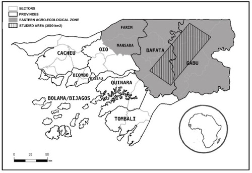
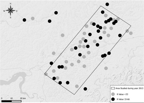
The area under study is located in Eastern Guinea-Bissau (about 18,000 km2), which is its most homogeneous region both in agro-ecological and ethnic terms (). It is a hinterland region covered by savannah woodlands and extensive grasslands and has the lowest rainfall, the highest temperatures and the poorest lateritic soils [Citation21]. The highest point reaches 298 m altitude in the Boé ills. According to FAO [Citation22] classification, the main upland agricultural soils where shifting cultivation is practiced are ferralsols and the flooded lowlands where freshwater swamp rice is annually cultivated are gleysols. Studying climate characteristics of this region between 1950 and 2001, Embalo [Citation23] concluded that: the average monthly highest temperature is 41.7 °C and occurs between April and May; the highest and lowest temperatures increased 0.8 °C during the last fifty years; and the average annual rainfall is 1169 mm, with a minimum of 314 mm and a maximum of 1885 mm. He argues that during the last twenty years a reduction occurred in the precipitation amounts and in the length of the rainy season (at present the rainy season usually starts in June and ends at the beginning of September/early start of October), as well as an increase in the variability of the distribution of the rains [Citation23].
The dominant ethnic groups in the East are the Fula (also known as Fulbe or Peul in other West African countries) − the second largest ethnic group of Guinea-Bissau, amounting to 25.4% of the country’s population in 1991–and the Mandinga (also known as Mandinka and Mandingo in other countries) − amounting to 13.7% of the country’s population [Citation24]. The average population density in the East is 28.6 people per km2, but it ranges from 3.3 to 49.0 among the different administrative sectors in which the provinces are divided [Citation25].
During colonial times, the production of peanuts for export under shifting cultivation practices greatly contributed to the deforestation and soil degradation of the region [Citation26]. By 1959, a reforestation plan was elaborated and cashew trees were included due to their rusticity and high tolerance to drought and poor soils [Citation27]. The colonial government tried to boost the plantation of cashews, but at that time farmers did not find any advantages in producing the cash crop [Citation28]. After independence in 1974, but especially after the adoption of structural adjustment measures (mid-1980s) which promoted the increase of the country’s exports, farmers progressively started to plant cashew trees. They adopted an “agricultural frontier” process, in which every field slashed is no longer left fallow anymore; instead, cashews are cultivated together with food crops during three to four years, until the field becomes an orchard, when the cashew trees canopy closes, and a new area must be slashed and burnt [Citation28]. In this process, all fallow fields, woodlands and savannah woodlands of the country are being converted into cashew orchards, concomitantly with a progressive expansion of the agricultural area [Citation28]. Customary land tenure rules, the absence of a land market and low population densities in most rural areas facilitated this process of land-use cover change [Citation29].
1.1.2 Study design, sampling and data collection
Based on the results of our own long-term field research coupled with Catarino [Citation30] division of the country in phytogeographical regions, we divided the territory of Guinea-Bissau into three social and agro-ecological relatively homogeneous regions: North and South on the coast and East in the interior (see ). The main difference to the usually adopted division consists in including the Farim and Mansabá sectors of Oio province in the East, instead of in the North.
During six weeks in 2008 and 2009, qualitative research (focus group discussions, key informants interviews, informal conversations, transects and visits to agricultural fields) was conducted by the first author in forty eight villages of Eastern Guinea-Bissau, within a project that covered the whole country aiming to monitor deforestation and land use-cover changes (1990–2007). The ethno-agronomic component characterized farming systems and fire practices in a context of land use-cover and socio-economic rapid change. This research provided not only important qualitative data for the characterization of shifting cultivation, but also the knowledge that the system was being substituted by cashew trees plantation. The research occurred at a time when shifting cultivation was no longer used by farmers and no more land was being left fallow anymore. Despite the use of remote sensing technologies in this multidisciplinary project [Citation31], the spatial and spectral resolution of Landsat satellite images and the classification trees’ classifiers did not allow to distinguish woodlands from cashew orchards (carboveg-gb.dpp.pt), making it not possible to calculate accurate rates of deforestation and forest degradation and recent land-use changes.
Due to its social and agro-ecological relatively homogeneity, the East was then chosen in 2012 to conduct another multidisciplinary research (combining remote sensing, fauna and flora biodiversity and ethno-agronomic studies) on the impact of cashew nuts plantation in terms of livelihoods, biodiversity and environmental services. In the first phase of the sampling process, we used high resolution images on Google Earth to select thirty villages on which to conduct a pilot research to test the methodology during three weeks in 2012. We selected villages with an average population (between 100 and 500 inhabitants); a territory of influence within a radius of more than 2 km from the village center; existence of cashew orchards and forest patches big enough to conduct fauna and flora biodiversity studies; and a homogenous distribution in the area under study [Citation32]. In the second phase we began to select a rectangular area of 3600 km2 with available high resolution images on Google Earth and Bing Maps. The area included seven hundred villages (mostly located in the Northeast side of the rectangle), of which seventy matched the same selection criteria mentioned above. We then randomly sampled forty five villages to conduct the multidisciplinary research during two months in 2012–2013 [Citation32]. Considering that the same selection criteria and interview guide were used, in this article we analyze data from both fieldwork periods. However, in order to decrease variability due to socio-cultural variables, we only included the sixty six Fula villages where interviews took place (i.e., the nine Mandinga villages were excluded).
The study of previous shifting cultivation practices was only a small component of the research agenda, and our questions focused on the average number of years a field was usually cultivated and left in fallow before the introduction of cashew nuts, the first crop before and after cashew nuts introduction, the year in which more than half of the households in each village possessed cashew orchards, former (before cashew nuts introduction) and present land pressure/availability, and what would household heads do under conditions of low cashew nuts price and high rice price when no more land will be available for food production (to access whether or not they would slash-and-burn old orchards and return to shifting cultivation, integrating cashew trees in planted fallows, as observed among few farmers). In each village, following local custom, we began by asking the village head for permission to carry out the study and then asked him to call all household heads to participate in a group interview aimed to characterize farming systems at a village level. During the research process, we lived in twenty one villages (of the sampled sixty six), in which we also used other research techniques, such as direct and participant observation and interviews with key informants. All interviews were conducted in Guinea-Bissau Kriol by the authors or in any local language/dialect (and then translated to Kriol by a field assistant), when informants were not fluent in the vernacular language. Unless otherwise stated, all data were collected by the authors.
1.1.3 Data analysis
In this article, we adopt the concept of permanent cultivation in a more strict sense for annual cropping (R = 100) − as it is practiced in both freshwater and in the fields around villages intensively manured by cattle and human waste − than the one used by Ruthenberg [Citation2]. Consequently, we introduce the concept of short fallow (R between 66 and 99).
Quantitative data were analyzed using SPSS, version 22. One-way ANOVA tests were performed using SPSS, version 22 to assess the differences of the mean R-Value over different parameters: length of cultivation and fallow periods, first crop, cashew nuts introduction, village population and land availability. Spearman correlation tests were also used to assess the relation between the length of cultivation period and fallow years.
2 Results
2.1 On people, crops, tools and techniques
The Fula are cattle herders although only a sub-group of the Fula can be considered as true pastoralists. Fermented milk is a component of their diet and millet, sorghum and fonio are the main staple food, although rice is also eaten. In general, farmers sell (and exchange with cereals) a part of their stock of goats, sheep and/or cattle to fulfill their subsistence needs. Their livelihoods also include trade, numerous craft activities, professional hunting, seasonal migration and divination/healing/protection activities using the Qur’an.
Farmers have a multiplicity of fields in which they use different cultivation techniques and intensification pathways. Shifting cultivation was practiced in the savannah woodlands, exception made for Boé sector where it was done in the riparian forests. In these upland fields, cereals (for home consumption), peanuts and calabashes (mostly for the market) cultivation was typically a men’s job. After independence, women started to engage in peanuts cultivation as an individual source of income. In the high manured fields − due to cattle roaming and settling overnight−near the houses, no fallow is needed and cereals and groundnuts are still intensively cultivated by men. The same applies to the backyard gardens, where men produce rain-fed maize sometimes followed by tomatoes. In the flooded grasslands, women grow freshwater swamp rice. In most of the villages, after the rice harvest they engage in vegetables’ production for the market; these lowland fields, then, stay permanently cropped by women along the year, in which soil fertility is maintained through the application of manure (sometimes agrochemicals too). Today some women also have an individual-for-profit cashew orchard.
Shifting cultivation practices in the East of Guinea-Bissau were markedly different from the ones used in the rest of the country. While in the North and South trees and shrubs were slashed and stumps sprouted during the rains, in this region only shrubs were slashed, but trees were killed by fire and/or girdling. Killed trees stayed standing and were progressively felled and burnt along the cultivation cycle to increase soil fertility each year with the resulting ashes. However, some useful species − Parkia biglobosa, Khaya senegalensis, Pterocarpus erinaceus and Prosopis africana − were also protected when the trees were big. Agricultural and non-agricultural fires were set to spread in the savannah woodlands, being used for a variety of purposes. The soil underwent a medium tillage with a hoe to uproot the weeds, but ox or donkey-ploughing (and also draft-sowing and weeding) were introduced after Independence in some villages. Sowing of sorghum, millet or maize was (and still is, but at present intercropped with cashews) done with the help of a digging stick or a small hoe and the seeds were buried with one foot. Flat-cultivation was only done in the first year of farming and in the better soils, followed by mound-cultivation in which the weeds were buried to increase soil fertility. Sorghum and millet stalks are not eaten by cattle (contrary to maize and peanuts’ stubble) and were burnt in the field to increase soil fertility. The importance of organic manure in the maintenance of soil fertility diminished after independence due to a decrease/extinction of the herds, in result of epidemics, and cattle’s use as bridewealth, to pay migration costs, and to buy cereals in times of food scarcity.
shows the relative importance of the different possible first crops. Depending on farmers’ preferences, soil conditions and the intensity of birds’ attack, either sorghum, rice or millet were used as the first crop, but when the field had too many weeds peanuts could also start the crop sequence. In villages/fields where the woodlands were denser, rice could be used as the first crop and, on the contrary, in open savannah woodlands millet was usually sown. Group preferences could restrict farmers’ options in case only one (or few) wanted to sow millet, due to risks of intensive birds’ attacks and the need to spend too much time watching the field.
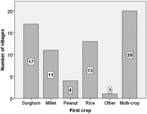
The crops could be cultivated in pure strands or in crop associations of few different species. Intercropping of peanuts with sorghum and/or millet sown in lines was the most frequent crop association (though the distance between sorghum lines, whose panicle bends and shades other crops, had to be wide). According to farmers, when the field was large it could be divided into two to four parcels where several crops were cultivated in pure strands (sorghum, millet and peanuts were the main crops, but a plot of maize could be added) followed by crop rotations in the subsequent years. This technique was the most used (30% against 26% by sorghum) in our sample villages. Maize was only cultivated under shifting cultivation, when farmers had cattle, cattle theft was not common and the animals could be left at night in one parcel of the field for some weeks to manure the soil. Besides maize and rice, well-known for their higher soil fertility requirements, white sorghum is also considered to be more demanding than red (ideal for sandy soils) and black sorghum varieties and the two millet varieties (with and without awns) cultivated in the East. provides examples of crop sequences and crop associations (and the corresponding crop and fallow lengths and R values) usually adopted in some sampled villages, illustrating the diversity of combinations and corresponding plausible impact in terms of soil fertility and tree cover recovery potential during fallow.
Table 1 Examples of different crop and fallow lengths and cropping sequences in studied villages.
2.2 Crop length, fallow period and “R value”
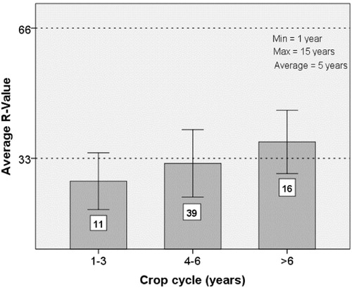
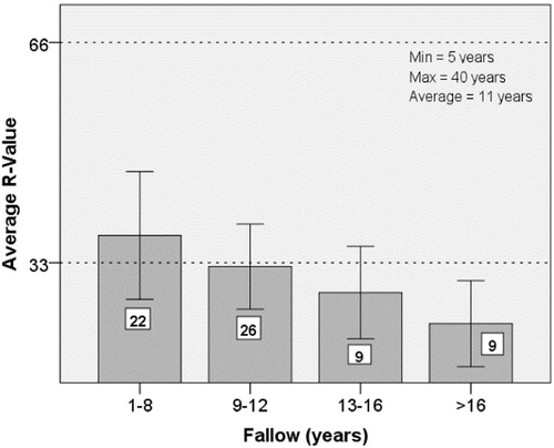
Cropping cycles in the region under study could last up to fifteen years with an average of five years (). The fallow periods show an even wider range of variation between five and forty years (). A significant positive correlation (p < 0.05) between the length of the cultivation and fallow periods was found, which means that longer fallows are associated with longer cropping periods. Although the shortest fallows are associated with the highest R values (), all classes show very low land use intensity. It is also worth mention that the highest (58.8) and the lowest (12.5) R values of our sample occurred in two villages which used the same fallow length (seven years).
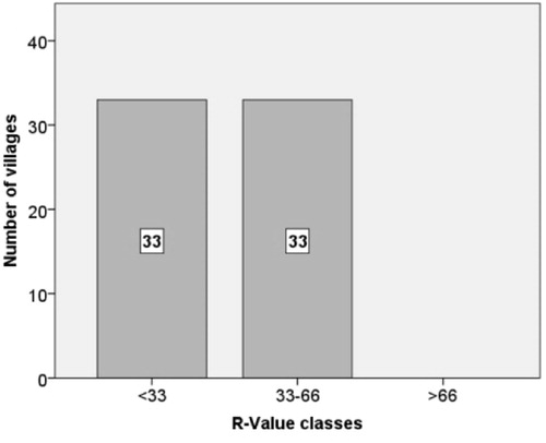
shows the frequency distribution of the R value class. The villages are distributed evenly between the two lower classes. Despite the fact that very short fallows were used in a significant number of villages in the region, no R value above 66 was found. Even the village with the highest R value (58.8) is still below the 66 threshold; this means that in no case a breakdown of shifting cultivation was about to happen due to soil fertility depletion, before the adoption of permanent cultivation with cashew orchards.
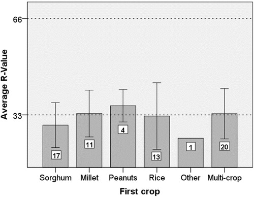
illustrates the mean R value according to the first crop used after slash-and-burn. ANOVA showed that there are no significant differences (p < 0.05) on the different possible first crops used. However, peanuts are the crop that shows both a higher average R value and a smaller standard deviation. As exemplifies, the same R value class can correspond to rather different cropping periods, fallow lengths, and cropping sequences.
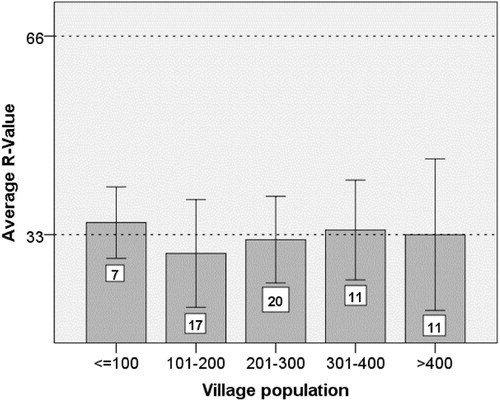
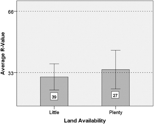
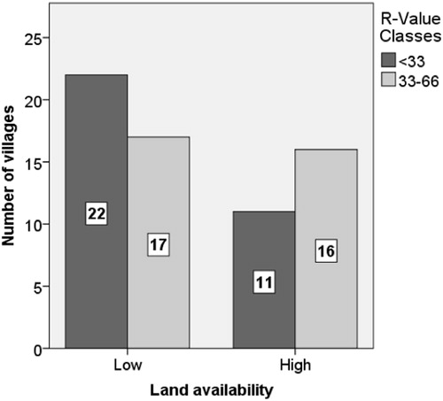
As stated before, independently of the region and of the previous characteristics of shifting cultivation practices, and mainly after the civil war of 1998-99, farmers all over the country started converting shifting cultivation fallows and remaining forests into cashew orchards. Despite the fact that no R value above 66 was found in our sample, we decided to cross check if this process could be related with villages’ population size or present availability of land ( and ). We found no significant differences (p < 0.05) either between the R value and the size of the population or the R value and land availability in each village. Moreover, we decided to test for a possible link between the R value and local ecological factors, by analysing its geographical distribution in the area under study. As we can see from , it is not possible to identify any clusters of villages with the same R value.
Moreover, when we group villages by R class and present land availability () we realize that the majority of the villages that now suffer from land shortage, at the time they practiced shifting cultivation they had an extensive use of land (R value < 33). Additionally, it was found no significant correlation (p < 0.05) between the average R value and the date at which more than half of the households in each village had adopted cashew trees production.
To access the irreversibility of the abandonment of shifting cultivation, we asked farmers what they would do when no more land will be available for food production in a context of high rice prices and low cashew nuts prices. In 14% of the sampled villages, farmers said that they will slash-and-burn the cashew trees and sow cereals and cashews again. In one of these villages, a farmer declared that he would instead slash-and-burn twenty meters’ width paths of cashews − where to produce food crops − and let cashew alleys of two lines of trees in between them. Moreover, of these nine villages where farmers were willing to slash orchards, in two of them there was still plenty of land available.
3 Discussion
In the region under study, a complex mixture of permanent cultivation and shifting cultivation practices characterized farming systems−until the introduction of cashew nuts’ orchards−and agriculture was only a component of a multifaceted livelihood system. The use of cereals tolerant to poor soils in crop sequences with peanuts, the yearly burning of some standing trees and the burying of the weeds during tillage allowed long cropping cycles in shifting cultivation. Nonetheless, very different crop and fallow lengths, and R values were used in a relatively small region with fairly homogenous ago-ecological and social conditions. Although no correlation was found between the mean R value and the first crop used in a cropping sequence, the fact that peanuts is the crop that shows a higher average R value and a smaller standard deviation, can be explained by farmers’ perception of peanuts as increasing soil fertility (being possible to cultivate it within a wide range of conditions and for several consecutive years). Some crop sequences can have greater negative consequences than others in terms of soil fertility depletion (and this was also acknowledge by our interviewees), though, and the same R value class can correspond to rather different cropping periods, fallow lengths, crops and cropping sequences. For the same class of “R value”, a cropping length of, e.g., three years and another of seven have different consequences in terms of forest regrowth potential under the slash-and-burn practices of Eastern Guinea-Bissau. As farmers recognize, soil fertility will also become much more depleted by a cropping sequence where rice (with the exception of short cycle varieties tolerant to poor soils) and/or sorghum are the cereals produced − especially if fonio is the last crop −, than by another that uses millet. Similarly, the yearly rotation with peanuts or its use only in the last years of long cropping sequences, starting with several consecutive years of cereals, will probably have very different impacts in terms of the regrowth of trees during fallow. Besides, higher R values will not have a bigger negative impact on soil fertility when villages have large cattle herds and they are allowed to roam in fallow fields.
As Gleave [Citation5] notes, literature on shifting cultivation and deforestation makes frequently bold generalizations about fallows and “commonly report a single fallow length for areas of unspecified extent” creating a simplistic idea, while “fallowing practices are quite complicated”. Our results for Eastern Guinea-Bissau − a region selected, as stated before, due to its low population density and relative uniformity in terms of social and agro-ecological conditions − support Gleave’s statement and show that a wide range of fallow lengths were used in a small region of about 18,000 km2. Furthermore, the fallow length, in this case, cannot be used as a proxy of land use intensity, as both long and short fallows were associated with different classes of R value.
As previously said, the abandonment of shifting cultivation has been generally presented as inevitable under conditions of short fallow lengths and population increase [e.g.,Citation15,Citation1]. This case study shows that, not only the full adoption of permanent cultivation can happen under different conditions of population density and land pressure−and depend much more on farmers’ preferences and decision-making−, but also that the abandonment of shifting cultivation may be only temporary. Thus the “Boserupian transition” [Citation5] did not happen in our sampled villages, where no R value above 66 existed. Conversely, the return to shifting cultivation can occur without a reduction in population pressure, the loss of technological knowledge and/or decreasing access to “modern” inputs and capital. The “tool kit” characteristic of shifting cultivation practices provides an enormous plasticity and robustness to farmers’ livelihoods in resource-poor regions. While favourable economic opportunities (together with labor constraints, the increasing climate instability and a need to secure rights to land) triggered the demise of shifting cultivation through the creation of a cashew trees’ agricultural frontier [Citation28], this intensification pathway also increased farmers vulnerability to pests and diseases [Citation33], to regional, national and international markets (of cashew nuts and cereals), to political crisis and to institutional changes [Citation28]. Besides, cashew plantations have a productive life of a maximum of twenty five years, which in Guinea-Bissau is reduced by the high density of the orchards and the absence of the use of fertilizers, pest control measures and irrigation. These conditions open a window of opportunity for the development of more environmental-friendly agroforestry alternatives.
4 Conclusions
This article is a contribution to building more robust frameworks to explain the relationship between fallow lengths and crop-fallow time ratios with the sustainability of shifting cultivation, and with the factors that can trigger its abandonment. It also illustrates the need for comparative studies on soil fertility under different management decisions − as the ones led by Mertz et al. [Citation8] −, on the demography of shifting cultivators − again, as done by Mertz et al. [Citation34] −, and on the relative importance (in terms of land and labor inputs) of this practice in relation to other cultivation practices simultaneously used by farmers. Before any generalizations can be done about the breakdown of shifting cultivation under shortening fallows, one has to understand the socio-economic and agro-ecological conditions under which shifting cultivation practices are being abandoned (or re-activated). The article, then, is one more example of the dynamic interactions between technology, environment and society, which make many African farming systems robust to abrupt socio-economic, political and environmental changes [Citatione.g.,11].
The demise of shifting cultivation in Eastern Guinea-Bissau prompted two opposite processes which exemplify the complex relationship between deforestation and these agricultural practices: the intensification of land use in former shifting cultivation fields and fallows through trees plantation; the extensification of land use, as more area was brought into cultivation at the cost of remaining woodlands and savannah woodlands patches through the use of less labor intensive practices. This fact is in line with Pollini [Citation35] statement that shifting cultivation “can be a cause of, as well as a buffer against deforestation”. The environmental impact of the observed land use-cover change is still unknown, though. By the one hand, the carbon sequestration potential of cashew orchards versus the one of shifting cultivation mosaic landscapes has to be assessed; by the other hand, the orchards may have reduced GHG emissions by creating a permanent tree cover and by decreasing the occurrence and extent of agricultural and non-agricultural fires. However, both natural [Citation36] and agricultural bio-diversity became depleted. Following from that, we argue that land change science will only develop by strengthening inter-disciplinary research using a long-time frame [Citationsee,e.g.,37]. This will provide a deeper understanding of land use-cover change drivers in specific locales and help the participatory development of packages of options to ameliorating our global environment, while improving the livelihoods and the food security conditions of poor farmers in marginal regions.
Conflict of interest
The authors declare no conflict of interest.
Acknowledgements
Research in 2008 and 2009 was conducted within the framework of the project ‘Assessment of CO2 removal capacity and quantification of carbon stocks in the forests of Guinea-Bissau’ funded by the Guinea-Bissau and Portuguese Governments, and by grants from the Portugal-Africa Foundation. In 2012 and 2013 fieldwork was continued within the framework of PTDC/AFR/1117785/2010 project, funded by the Portuguese Foundation for Science and Technology (FCT). An earlier version was presented at Wageningen University in September 2015 and received important comments by Paul Struik, Paul Richards, Tsjeerd-Jan Stomph and Béla Teeken. We are also grateful to the editor and reviewers of NJAS and to Rute Caeiro, Luis Catarino, Rui Figueira, Pedro Talhinhas for many comments and suggestions.
References
- W.RussellPopulation, swidden farming and the tropical environmentPopul. Environ.1019887794
- H.RuthenbergFarming Systems in the Tropics1976Oxford Clarendon Press
- N.BradyAlternatives to slash-and-burn: a global imperativeAgric. Ecosyst. Environ.581996311
- C.PalmS.VostiP.SanchesP.EricksenSlash-and-burn Agriculture: the Search for Alternatives2005Columbia University PressNew York
- M.GleaveThe length of the fallow period in tropical fallow farming systems: a discussion with evidence from Sierra LeoneGeogr. J.16219961424
- L.ThruppS.HechtJ.BrowderThe Diversity and Dynamics of Shifting Cultivation: Myths, Realities and Policy Implications1997World Resources InstituteWashington DC
- A.IckowitzShifting cultivation and deforestation in tropical Africa: critical reflectionsDev. Change372006599626
- O.MertzR.WadleyU.NielsenT.BruunC.ColferA.NeergaardM.JepsenT.MartinussenQ.ZhaoG.NowegJ.MagidA fresh look at shifting cultivation: fallow length an uncertain indicatorAgric. Syst.9620087584
- S.FujisakaL.HurtadoR.UribeA working classification of slash-and-burn agricultural systemsAgrofor. Syst.341996151169
- H.C.ConklinHanunoo Agriculture: a Report on an Integral System of Shifting Cultivation in the Philippins1957FAORome(Forest Development papers, 12)
- P.RichardsCoping with Hunger Hazard and Experiment in a West African Rice Farming System1986UCL PressLondon
- A.IckowitzShifting cultivation and forest pressure in CameroonAgric. Econ.422011207220
- A.AwetoA.IyandaEffects of Newbouldia laevis on soil subjected to shifting cultivation in the Ibadan area, Southwestern NigeriaLand Degrad. Dev.1420035156
- J.Kotto-SameP.WoomerM.AppolinaireZ.LouisCarbon dynamics in slash-and-burn agriculture and land use alternatives of the humid forest zone in CameroonAgric. Ecosyst. Environ.651997245256
- E.BoserupThe Conditions of Agricultural Growth: the Economics of Agrarian Change Under Population Pressure1965Allen & UnwinLondon
- A.AwetoTrees in shifting and continuous cultivation farms in Ibadan area, Southwestern NigeriaLandscape Urban Plann.532001173–171
- M.TiffenM.MortimoreF.GichukiMore People, Less Erosion: Environmental Recovery in Kenya1994John Wiley & SonsNew York
- D.BrownPersonal preferences and intensification of land use: their impact on southern Cameroonian slash-and-burn agroforestry systemsAgrofor. Syst.6820065367
- M. P. Temudo, ‘The White Men Bought the Forests: Conservation and Contestation in Guinea-Bissau, West Africa’, Conservation and Society 10 (2012): 354–366.
- R.CrambC.ColferW.DresslerP.LaungaramsriQ.LeE.MulyoutamiN.PelusoR.WadleySwidden transformations and rural livelihoods in Southeast AsiaHum. Ecol.372009323346
- L.CatarinoE.MartinsM.BastoM.DinizAn annotated checklist of the vascular flora of Guinea-Bissau (West Africa)Blumea5320081222
- FAO-ISRIC-ISSS, World reference base for soil resources. World Soil Resources Report 84 (1998).
- G.EmbalóA vulnerabilidade da população, às alterações agro-ecologicas: estudo de caso no sector de Pirada, região de Gabu/Guiné-Bissau, Master dissertation2008ISA −UTLLisboa
- INECRecenseamento geral da população e habitação 19911996Ministério do Plano e Cooperação InternacionalBissau
- INECRecenseamento Geral da População e Habitação2009(accessed 03.01.2012)http://www.stat-guinebissau.com
- A.CarreiraPopulação autóctone segundo os recenseamentos para fins fiscaisBoletim Cultural da Guiné Portuguesa661962221280
- A.HortaAnálise estrutural e conjuntural da economia da GuinéBoletim Cultural da Guiné-Portuguesa201965333496
- M.P.TemudoM.AbrantesThe cashew frontier in Guinea-Bissau, West Africa: changing landscapes and livelihoodsHum. Ecol.2014217230
- M.P.TemudoM.AbrantesRural livelihoods and social stability in Guinea-Bissau: the end of an era?P.ChabalT.GreenGuinea-Bissau : from Micro-state to Narco-state2016HurstLondon8395
- L. Catarino, Fitogeografia da Guiné-Bissau. PhD dissertation Lisboa, ISA/UTL, 2004.
- D.OomP.LourençoA.CabralM.VasconcelosL.CatarinoV.CassamáJ.MoreiraQuantification of deforestation rates in Guinea-Bissau: a baseline for carbon trading under REDD33rd International Symposium on Remote Sensing of EnvironmentMay 4–8 2009 Stresa, Italy(2009)
- P.SantosCulturas de rendimento e segurança alimentar na Guiné-Bissau Coimbra Master Dissertation2014ESA
- S.VasconcelosL.MendesP.BejaC.HodgsonL.CatarinoNew records of insect pest species associated with cashew, Anacardium occidentale L. (Anacardiaceae), in Guinea-BissauAfr. Entomol.222014673677
- O.MertzS.LeiszA.HeinimannK.RerkasemW.Thiha DresslerV.PhamK.VuD.Schmidt-VogtC.ColferM.EpprechtC.PadochL.PotterWho counts? Demography of swidden cultivators in Southeast AsiaHum. Ecol.372009281289
- J.PolliniSlash-and-burn agricultureP.ThompsonD.KaplanEncyclopaedia of Food and Agricultural Ethics2014Springer
- S.VasconcelosP.RodriguesL.PalmaL.MendesA.PalminhaL.CatarinoP.BejaThrough the eye of a butterfly: assessing biodiversity impacts of cashew expansion in West AfricaBiol. Conserv.1912015779786
- D.CampbellD.LuschT.SmuckerE.WanguiMultiple methods in the study of driving forces of land use and land cover change: a case study of SE Kajiado District KenyaHum. Ecol.332005763794