
 ?Mathematical formulae have been encoded as MathML and are displayed in this HTML version using MathJax in order to improve their display. Uncheck the box to turn MathJax off. This feature requires Javascript. Click on a formula to zoom.
Abstract
In the course of the IAG African Geoid Project, it is needed to study the impact of the lakes on the gravity reduction and geoidal heights. The aim of this paper is to study the impact of the water in Nasser Lake on gravity reduction and geoidal heights for Egypt. The determination of the gravimetric geoid is based on the well-known remove-restore technique. The problem of the lakes occurs because the popular programs widely used in practice (e.g., TC-program (Forsberg, 1984)) assume that all positive elevations are filled with rock topography, and all negative elevations are filled with ocean water. This is, however, not true for the case of Nasser Lake, which lies completely above sea level, at about 180 m elevation, with a water depth of about 20 m. The paper presents an approach on estimating the impact of Nasser Lake on gravity reduction and geoidal heights using TC-program with some tricky cases. The results show that the impact of Nasser Lake on both gravity anomalies and geoid undulation is limited to the area of the lake. The impact of Nasser Lake on the gravity anomalies is in the order of sub mgal, while the impact of Nasser lake on the geoid undulation is significant and reaches few centimeters.
1 Introduction
In order to apply Laplace equation, there should be no masses outside the geoid (CitationHeiskanen and Moritz, 1967). This implies removing, mathematically, the topographic masses and their compensating masses. This process is known in physical geodesy as gravity reduction. The remove-restore technique (CitationForsberg, 1984) is widely used in practice. CitationAbd-Elmotaal and Kühtreiber (2003) have proposed a more accurate remove-restore technique by introducing the so-called window technique. In both techniques, the effect of the topographic masses are removed using TC-program (written originally by CitationForsberg (1984)) or its modified version (written by CitationAbd-Elmotaal and Kühtreiber (2003)). As TC-program uses unclassified Digital Height Models (DHMs), it assumes that all positive elevations are filled with rock topography, and all negative elevations are filled with ocean water.
In the case of Nasser Lake, the situation is quite different. The whole lake is located above the sea level. Thus it has positive elevations. TC-program thus treats the water masses inside the Nasser Lake as rock topography instead of water masses. Accordingly, the main aim of the current investigation is to determine the impact of the Nasser Lake on both the gravity reduction and the geoid undulation.
The study area is defined and an overview of the Nasser Lake is given. The available Digital Height Models for the current investigation are described. The Stokes’ technique of the geoid determination, within the remove-restore scheme, is outlined. The used images for determining the lake and the necessary image analysis has been given. The approach of determining the impact of the Nasser Lake on the gravity reduction and the geoid undulation using TC-program is explained and then implemented.
It should be noted that the area of Lake Nasser attracts a number of interesting studies. Some studies were interested in computing a local geoid for the Nasser Lake area (see, e.g., CitationTscherning et al., 2001). Other studies were tackling the important topic of the crustal deformation in the area of Lake Nasser (cf., e.g., CitationZahran and Abdel-Monem, 2006).
2 Study area – Nasser Lake
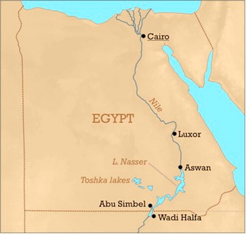
Nasser Lake is one of the largest artificial freshwater reservoirs in the world. It is considered as the largest artificial reservoir in Africa by volume (excluding continental lakes, e.g., Tanganyika). The Lake is located in southern Egypt and northern Sudan. Strictly, “Lake Nasser” refers only to the much larger portion of the lake that is in the Egyptian territory (83% of the total area), (cf. ). The Sudanese prefer to call their smaller portion of the lake “Lake Nubia”. This study concerns the whole area of the lake. The lake was created after the construction of the High Dam across the River Nile waters during the 1960s. The lake lies between latitudes , extends over 500 km long upstream of the High Dam, and has a width of 35 km at its widest point (near the Tropic of Cancer). At 182 m water level (above mean sea level), the lake has an average width of about 12 km and covers a surface area of 5237 km2 with a storage capacity of some 150–165 km3 of water (CitationZwieten et al., 2011).
Fig. 1 Lake Nasser location.
Nasser Lake is valuable for Egypt as it represents a large reservoir for the country’s freshwater resources. The location of the lake is characterized by an extremely arid climate, with a wide diurnal variations and almost no precipitation. The volume of the water in the lake fluctuates greatly annually and seasonally depending upon the net annual volume of water it receives and the operation of the High Dam. shows the lake level fluctuation as inferred from satellite altimetry (LEGOS/GOHS) from 1992 to 2011. The highest recorded water level during this period was 181.2 m (above mean sea level) in November 1999, while the lowest level recorded so far was 167.2 m in July 1993. In this study, satellite images, namely Landsat-7 ETM+ images, are used to determine the boarders of the lake as described in Section 7.
Fig. 2 Lake level variation of Lake Nasser from satellite altimetry (LEGOS/GOHS) (reference point: ).

3 Digital height models DHMs
In the context of the remove-restore technique (CitationForsberg, 1984), a set of fine and coarse DHMs is needed for the terrain reduction computation. The fine Digital Height Model EGH13S03 and the
coarse Digital Height Model EGH13S30 (CitationAbd-Elmotaal et al., 2013) are available for this investigation. These DHMs cover the full window of
. illustrates the
fine EGH13S03 for the Lake Nasser area
. The heights within the Nasser Lake area range between
m and 1961 m with an average of about 289.1 m and a standard deviation of 293.8 m.
Fig. 3 The fine Digital Height Model EGH13S03 (after CitationAbd-Elmotaal et al. (2013)) for the Nasser Lake area. Units in [m].

4 Remove-restore technique
The remove-restore technique consists of two steps. The first step is performed to remove the effect of the topographic-isostatic masses and the effect of the global geopotential model from the source gravitational data. In the second step, the effect of the topographic-isostatic masses and the effect of the global geopotential model to the resulting geoidal heights are restored. For example, in the case of gravity data, the reduced gravity anomalies in the framework of the remove-restore technique are computed by (see e.g., CitationRapp and Rummel (1975)Citation, Forsberg (1993)Citation, and Sansó (1997))(1)
(1) where
stands for the free-air anomalies,
is the effect of topography and its compensation on the gravity anomalies, and
is the effect of the reference field on the gravity anomalies. Thus, the final computed geoid N within the remove-restore technique can be expressed by
(2)
(2) where
stands for the contribution of the reference field,
stands for the contribution of the reduced gravity anomalies, and
is the contribution of the topographic-isostatic masses (the so-called indirect effect).
The above traditional remove-restore techniques faces a theoretical problem of the double consideration of some of the topographic-isostatic masses around the computational point. A possible solution of this problem has been made by introducing the window remove-restor technique (CitationAbd-Elmotaal and Kühtreiber, 1999, Citation2003).
The remove step for the window remove-restor technique is given by(3)
(3) where
stands for the window-reduced anomalies,
refers to the effect of the topographic-isostatic masses for a fixed full data window and
is the contribution of the harmonic coefficients of the topographic-isostatic masses of the data window. The harmonic coefficients of the topographic-isostatic masses can be computed using the expressions given in CitationAbd-Elmotaal and Kühtreiber (2003), or more precisely using the expression given in CitationAbd-Elmotaal and Kühtreiber (2015).
The restore step for the window remove-restor technique is given by(4)
(4) where
stands for the contribution of the window-reduced gravity anomalies, and
is the contribution of the topographic-isostatic masses for the fixed data window and
is the contribution of the harmonic coefficients of the topographic-isostatic masses of the data window.
The computation within the window remove-restore technique is rather time consuming. This depends essentially on the resolution of the used DHMs. Accordingly, one needs to define the optimal DHM resolutions for both the terrain reduction (using TC-program) and the computation of the harmonic coefficients of the topographic-isostatic masses of the data window. The reader is then kindly invited to refer to CitationAbd-Elmotaal (2011)Citationand Abd-Elmotaal and Kühtreiber (2014).
5 Stokes’ technique
The Stokes’ equation expresses the geoid undulation in terms of a convolution of the gravity anomalies with the Stokes’ function. Using Stokes’ equation, the contribution of the reduced gravity anomalies is given by (CitationHeiskanen and Moritz, 1967)
(5)
(5) where
is the normal gravity, R is the mean Earth’s radius and
stands for the Stokes un-modified kernel given by (CitationStrang van Hees, 1990)
(6)
(6) with
(7)
(7) and
is the spherical distance between the computational point P and the running point Q. The evaluation of the integral in Eq. (Equation5
(5)
(5) ) is performed by numerical integration. Hence, the integral is replaced by a summation over two parameters covering theoretically the whole surface of the Earth. Thus, Eq. (Equation5
(5)
(5) ) becomes
(8)
(8) More details can be found, e.g., in CitationStrang van Hees (1990)Citationand Abd-Elmotaal (2014).
6 Methodology
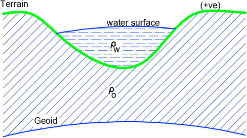
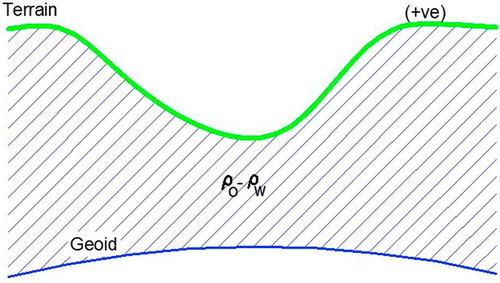
The elevation of the water in Nasser Lake is about 182 m above the sea level. As shown in , the masses above the geoid consist of two different material; rock topography with an average density of 2.67 g/cm3, and water with density of about 1.03 g/cm3.
Fig. 4 The original case: the lake is completely located above the mean sea level.
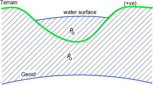
The TC program (CitationForsberg, 1984), after the significant modifications made by CitationAbd-Elmotaal and Kühtreiber (2003), has been used to compute the effect of topographic masses on both the gravity anomalies and the geoid undulation. As mentioned above, TC-program uses unclassified DHMs, and thus treats the masses above the geoid as rock topography with an average density of 2.67 g/cm3 (cf. ).
Fig. 5 The “wrong” case assumed by TC-program with unclassified DHMs.
The following two cases have been considered to compute the correct impact of the Nasser Lake on the gravity anomalies and geoid undulation:
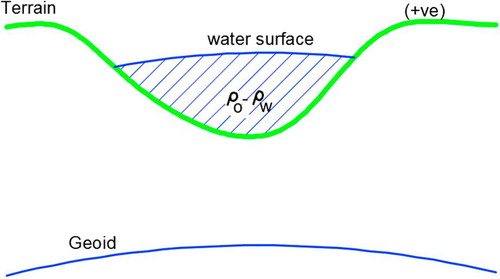
| 1. | Case (1): Consider the masses above the geoid with a constant density of | ||||
| 2. | Case (2): Remove the lake part from the DHM and then consider the masses above the geoid of density | ||||
Fig. 6 Case (1) of the suggested approach.
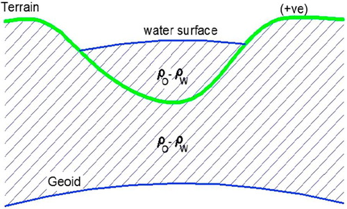
Fig. 7 Case (2) of the suggested approach.
Accordingly, by subtracting case (2) from case (1), one gets the impact of the Nasser Lake on the gravity reduction and geoid undulation (cf. ).
Fig. 8 The difference between case (1) and case (2) equals the impact of Nasser Lake.
7 Image analysis
In this study, three scenes of Landsat-7 images covering the entire lake are used. The images are available on USGS Global Visualization Viewer (GloVis): http://glovis.usgs.gov/. shows the details of the used images. Lake Nasser is covered by three scenes located in two paths (namely; P174 and P175) as shown in .
Fig. 9 Locations (in path/row) of the used Landsat images in WRS-2 of Landsat-7.
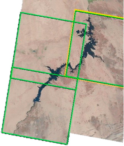
Table 1 Acquiring data of Landsat images.
In this work, the used images are SLC-off images (cf. ). In order to fill the gaps in SLC-off images, it is possible to combine two SLC-off scenes (primary scene and fill scene) to create a somewhat completely filled final image (CitationChen et al., 2011). The choice of the primary and fill scenes should be based on specific criteria, as follows:
| • | Both primary and fill scenes should be cloud free as far as possible, | ||||
| • | The date of the fill scene should be as close as possible to the date of the primary scene. Here, the fill scene is chosen to be directly following the primary scene during the same month. The time difference between the two successive scenes is the repeat-cycle period of Landsat-7 (16 days), | ||||
| • | The area of interest should contain low temporal variability with respect to land cover and surface features, and | ||||
| • | There should be minimal differences in transient conditions between the primary and fill scenes. | ||||
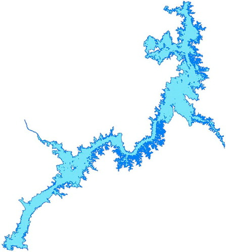
Filling gaps is done for this work using ERDAS Imagine TM model-maker tool. The three scenes are then mosaicked and corrected geometrically using ERDAS Imagine. The output image is then classified with an unsupervised classification tool, namely Iterative Self Organizing Data Analysis (ISODATA), in order to obtain the water body class of the lake. In the absence of field measurements, unsupervised classification is an effective technique for water texture recognition, especially in such arid regions. The ISODATA utility repeats the clustering of the image until the percentage of convergence threshold is reached. The convergence threshold is the maximum percentage of pixels whose cluster assignments can be unchanged between two successive iterations. Here, the convergence threshold is set as 0.97, which implies that as soon as 97 or more of the pixels stay in the same cluster between two successive iterations, the clustering utility stops processing. shows the classified images with the water class (representing the lake area) shown in cyan. The water class is then extracted as a vector format in using ArcGIS system. shows the water class vector representing Lake Nasser as extracted from ArcGIS system.
Fig. 10 Classification results for the considered Landsat images showing the water class representing Lake Nasser.
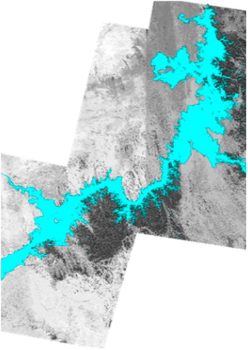
Fig. 11 Water class vector representing Lake Nasser as extracted from ArcGIS system.
8 Results and discussions
For estimating the impact of the Nasser Lake on the gravity anomalies and the geoidal heights in Egypt, the effect of the topographic masses of the fixed full data window () have been computed using the TC-program employing the Digital Height Models discussed above on a
grid covering the full data window. The fine EGH13S03 DHM has been used till a radius
of 6 km around the computational point, hence the coarse EGH13S30 DHM has been used for the rest of the full data window. The following parameters have been used because they proved practically to give the best results for Egypt (CitationAbd-Elmotaal, 2009)
(9)
(9) where
is the normal crustal thickness,
is the density of the topography and
is the density contrast between the crust and the mantle.
The density of the topographic masses for case (1) has been taken to be 1.64 g/cm3. Then, the Digital Height Models have been modified by subtracting the depths of the water in Nasser Lake region from the heights of the original Digital Height Models (representing the surface of the lake). Thus case (2) took place and the effect of the modified Digital Height Models on the gravity anomalies and the geoid heights have been computed at the same grid points as of case (1) having the same value for the density
. The differences between the results in the two cases have been computed and will be shown and discussed in the following sections.
8.1 Effect on gravity anomalies
shows the impact of the Nasser Lake waters on the gravity anomaly. shows significantly small effects on the gravity anomalies near and inside the lake and zero effect elsewhere. The effect of the Nasser Lake for the study area and
ranges between zero and 1.4 mgal with an average of 0.02 mgal and a standard deviation of 0.17 mgal.
Fig. 12 The impact of the Nasser Lake on the gravity anomaly. Units in [mgal].

8.2 Effect on geoid undulation
The effect of the gravity anomalies on geoidal heights has been computed using Stokes’ formula (Equation8(8)
(8) ) on a
grid covering the full window (
). shows the impact of the Nasser Lake on the geoid undulation. It shows that the impact of the Nasser Lake on the geoid undulation is about 4 cm near and inside the lake. The effect of Nasser Lake for the study area
and
ranges between 0.3 cm and 4.3 cm with an average of
cm and a standard deviation of 0.55 cm. The indirect effect of the lake is very small and can be neglected.
Fig. 13 The impact of the lake on the geoid undulation. Units in [cm].

9 Conclusions
The current investigation studied a very important point in the process of the geoid determination. It is the impact of the lakes. An approach using the widely used in practice TC-program to determine the impact of the Nasser Lake on the gravity anomalies and geoid undulation has been developed within the context of the current paper. In addition, Landat-7 ETM+ images are processed to precisely determine the boarders of the lake. The developed approach has successfully been implemented to compute the effect of Nasser Lake on gravity reduction and geoid determination. The results reveal that the impact of Nasser Lake on the gravity anomalies and the geoid undulations is limited only to the area of the Nasser Lake. The impact of the Nasser Lake on the gravity anomalies within the area of the lake is in the order of only sub mgal. However, the impact of the Nasser Lake on the geoid undulation is significant and reaches few centimeters, which is then needed to be considered for the cm-geoid.
Acknowledgements
This project was supported financially by the Science and Technology Fund (STDF), Egypt, Grant No. 7944. The support by the International Association of Geodesy (IAG) and the International Union of Geodesy and Geophysics (IUGG) is kindly acknowledged. The authors would like to thank the editors of the current paper and the anonymous reviewers for their useful comments.
Notes
Peer review under responsibility of National Research Institute of Astronomy and Geophysics.
References
- H.A.Abd-ElmotaalEvaluation of the EGM2008 geopotential model for EgyptNewton’s Bull.42009185199
- H.A.Abd-ElmotaalEffect of digital height models’ resolution on gravity reduction and geoid computation in EgyptNRIAG J. Geophys. Spec. Issue2011173192
- Abd-Elmotaal, H.A., 2014. Egyptian geoid using ultra high-degree tailored geopotential model. In: Proceedings of the 25th International Federation of Surveyors FIG Congress, Kuala Lumpur, Malaysia, June 16–21, 2014. URL <http://www.fig.net/pub/fig2014/papers/ts02a/TS02A_abd-elmotaal_6856.pdf>.
- Abd-Elmotaal, H.A., Abd-Elbaky, M., Ashry, M., 2013. 30 meters digital height model for Egypt. In: VIII Hotine-Marussi Symposium, Rome, Italy, June 17–22, 2013.
- H.A.Abd-ElmotaalN.KühtreiberImproving the geoid accuracy by adapting the reference fieldPhys. Chem. Earth Pt. A24119995359
- H.A.Abd-ElmotaalN.KühtreiberGeoid determination using adapted reference field, seismic Moho depths and variable density contrastJ. Geodesy.771–220037785
- H.A.Abd-ElmotaalN.KühtreiberThe effect of DHM resolution in computing the topographic-isostatic harmonic coefficients within the window techniqueStud. Geophys. Geodaet.5820144155
- Abd-Elmotaal, H.A., Kühtreiber, N., 2015. On the computation of the ultra-high harmonic coefficients of the topographic-isostatic masses within the data window. In: General Assembly of the European Geosciences Union, Vienna, Austria, April 12–17, 2015.
- J.ChenX.L.ZhuJ.E.VogelmannF.GaoS.M.JinA simple and effective method for filling gaps in Landsat ETM plus SLC-off imagesRem. Sens. Environ.115201110531064
- Forsberg, R., 1984. A Study of Terrain Reductions, Density Anomalies and Geophysical Inversion Methods in Gravity Field Modelling. Ohio State University, Department of Geodetic Science and Surveying, Rep 355.
- R.ForsbergModelling the fine structure of the geoid: methods, data requirements and some resultSurv. Geophys.141993403418
- W.A.HeiskanenH.MoritzPhysical Geodesy1967FreemanSan Francisco
- Rapp, R., Rummel, R., 1975. Methodes for the Computation of Detailed Geoids and Their Accuracy. Ohio State University, Department of Geodetic Science and Surveying, Rep 233.
- Sansó, F., 1997. Lecture Notes. Int School for the Determination and Use of the Geoid. Int Geoid Service, DIIAR-Politecnico di Milano, Milan.
- G.Strang van HeesStokes formula using fast Fourier techniquesManuscr. Geodaet.1541990235239
- C.C.TscherningA.RadwanA.TealebS.MahmoudM.A.El-MonumR.HassanI.El-SyaedK.SakerLocal geoid determination combining gravity disturbances and GPS/levelling: a case study in the Lake Nasser area, Aswan, EgyptJ. Geodesy757–82001343348
- van Zwieten, P.A.M., Béné, C., Kolding, J., Brummett, R., (Eds.), 2011. Review of Tropical Reservoirs and Their Fisheries in Developing Countries: The Cases of the Lake Nasser, Lake Volta and Indo-Gangetic Basin Reservoirs. Final Report for the Project: Improved Fisheries Productivity and Management in Tropical Reservoirs. CP-PN34: Colombo, Sri Lanka: CGIAR Challenge Program on Water and Food, Rome, 2011.
- K.ZahranS.Abdel-MonemModelling of gravity variation and crustal deformation due to the variable load in vicinity of the Lake Nasser, Aswan, EgyptGeophys. Res. Abstr.82006675