Abstract
Drawing on and speaking to literatures in geographic information systems (GIS), queer geography, and queer urban history, we chronicle ethnographically our experience as queer geographers using GIS in an action-research project. We made a map of sites of historical significance in Seattle, Washington, with the Northwest Lesbian and Gay History Museum Project. We detail how queer theory/activism and GIS technologies, in tension with one another, made the map successful, albeit imperfect, via five themes: colliding epistemologies, attempts to represent the unrepresentable, productive pragmatics, the contingencies of facts and truths, and power relations. This article thus answers recent calls in the discipline for joining GIS with social-theoretical geographies, as well as bringing a spatial epistemology to queer urban history, and a cartographic one to queer geography.

Usando y hablando sobre la documentación de sistemas de información geográfica (SIG), geografía homosexual e historia urbana homosexual, hacemos una crónica etnográfica de nuestra experiencia como geógrafos homosexuales mediante la aplicación de SIG en un proyecto de investigación y acción. Preparamos un mapa de áreas de importancia histórica en Seattle, Washington, en colaboración con el proyecto Northwest Lesbian and Gay History Museum Project. Detallamos cómo el activismo/teorías homosexuales y las tecnologías SIG, en tensión mutua, permitieron el éxito del mapa, aunque imperfecto, mediante cinco temas: epistemologías en colisión, intentos de representar lo irrepresentable, pragmática productiva, la eventualidad de hechos y realidades, y las relaciones de poder. Por esto, este artículo invoca la disciplina de unir los SIG con geografías sociales-teóricas, así como el acercamiento de una epistemología espacial a la historia urbana homosexual, y una cartográfica a la geografía homosexual.
Queer geography has often positioned itself—and been positioned by mainstream geography—as antithetical to the realms of more traditional, orthodox disciplinary anchors like cartography and GIScience (CitationBinnie 1995; CitationBrown 1995; CitationBrowne 2006). Emerging as it has from the discipline's critical-theoretical turn, queer geography's intellectual ken in queer theory and poststructuralism has certainly contributed to a thoroughgoing interrogation of Cartesian rationality, Euclidean spatial ontologies, and the often norming fixity inherent in cartographic representation. Queer geography has thus been quite distanced from conventional GIScience, often seeking alternate modes of spatial representation (e.g., CitationCieri 2003). Meanwhile, GIScience has neglected queer subjects and topics, even when it has broached related areas of feminism and postcolonialism (CitationRundstrom 1995; CitationKwan 2002a; CitationMcLafferty 2002; CitationSchuurman and Pratt 2002) and incorporated a sophisticated critical awareness of the social constructedness of spatial data, the vexing relations between epistemology and representation, and the political dimensions of geographic information systems (GIS; Harvey 2000; CitationAitken 2002; CitationCrampton 2004; CitationKyem 2004; CitationPickles 2004; CitationSchuurman 2004). Indeed, the vast intellectual and social distance between queer geography and GIS is a typical example of the often-lamented lack of a center or disciplinary focus in geography.
Amid this dissonance and centrifuge, it is arguably remarkable that two queer geographers might employ GIS techniques in an effort to execute an action-research project epistemologically and politically anchored in queer theory. Our project entailed work with an all-volunteer nonprofit organization in Seattle, Washington (the Northwest Lesbian and Gay History Museum ProjectFootnote 1 ), dedicated to recording, saving, and disseminating the twentieth-century history of lesbians, gays, and other sexual dissidents in the U.S. Pacific Northwest. Our work involved, quite simply, making a map using GIS and visual design software. Over several months in 2003–2004 we developed a GIS database of major sites of significance to the lesbian and gay populations of Seattle, Washington in the twentieth century, and designed a fold-out, illustrated, and annotated map. “Claiming Space: Seattle's Lesbian and Gay Historical Geography” premiered at Seattle's Pride Festival in June 2004.
By chronicling our research experience ethnographically our purpose here is to highlight the productive tensions of what we call colliding epistemologies in our use of GIS. In the course of our work, we experienced a number of problems and challenges arising from our attempts to tack back and forth between a queer theoretical framework and the more conventionally scientific strictures of cartography and GIS. Many of these problems have been anticipated by feminist and other critical geographers writing about GIS (CitationSieber 2000; CitationKwan 2002a; CitationMcLafferty 2002; CitationPavlovskaya 2002; CitationSchuurman 2002b; CitationSchuurman and Pratt 2002; CitationKyem 2004), but others resonate especially with queer geography, and have more to do with a broader set of intellectual paradoxes that emerge when the relentless and insistent poststructuralist drive to critically deconstruct (i.e., to queer) in academia engages with more pragmatic forms of activism and voluntarism (e.g., to make an essentializing map; CitationFyfe and Milligan 2003; CitationCameron and Gibson 2005), or when different literatures are brought into conversation with one another through empirical praxis.
Our project allowed us to tease out a broad set of insights that we hope speak to debates and issues in queer geography as well as GIS. Even more broadly, this article might address concerns over the allegedly increasing fragmentation of and dissonance in the discipline of geography, as well as debates over the relevance of geographic research. Our observations about this particular encounter between queer theory and GIS would seem, then, to be both novel and potentially important.
In what follows we first situate our project intellectually with respect to literatures on gay and lesbian urban history, queer geography, and critical and participatory GIS. We then offer an ethnographic account of the map-making process itself, which identifies several points of insight. Finally, we offer a set of conclusions about the implications of our insights for queer geography and GIS, and in particular about the relationships among queer forms of knowledge, fixed visual forms of representation (such as maps), and constitutive (as opposed to distributional or oppositional) politics.
Between Multiple Literatures
Queer Urban History
Our action-research project draws on and extends very strong and ongoing historical case studies about queer lives and spaces in twentieth-century urban America. Cities like New York (CitationChauncey 1994; CitationCarter 2004; CitationMcCourt 2004), San Francisco (CitationStryker and Van Buskirk 1996; CitationBoyd 2003), Buffalo (CitationLapovsky-Kennedy and Davis 1993), Philadelphia (CitationStein 2004), Boston (The History Project 1998), and Seattle (CitationAtkins 2003) have been researched in accessible, meticulous, and compelling case studies. Smaller cities and towns with a visible gay presence like Provincetown, Massachusetts (CitationKrahulik 2005), and Fire Island, New York (Newton 1983), have also been researched. This work has often concentrated on the so-called pre-Stonewall era (before 1969), and it serves both intellectual and political functions. Intellectually it complicates the heterosexist presumptions and ignorance of so much of mainstream urban history (for instance, in Seattle, see Morgan 1982), bringing it out of the closet, as it were. It adds dimension and multiple identities to the work in urban social history that have so often been ignored in the master narratives of that field and in local popular history. Politically, it describes and preserves an inspiring social history that is terribly difficult to find, and in so doing empowers new generations of queer activists. This constitutive political role reflects the very queer politics of attacking “the closet”: the metaphor that describes the denial, concealment, and erasure due to heteronormativity and homophobia (CitationSedgwick 1990; CitationBrown 2000). The closet, it is argued, is a unique form of oppression because unlike axes of gender, race, or class, one often is isolated from even one's closest friends and family, in ways that are often invisible or concealed. Therefore, the value of recording and disseminating historical geographies here is that they tell queer folks that we are not alone, and that there are rich and empowering tales of how others found community and empowerment in recent history. As such, these histories emphasize the importance of the closet to nascent queer communities and politics. In the eloquent words of historian Joan Nestle (1983, 35–56):
We need to know that we are not accidental, that our culture has grown and changed with the currents of time, that we, like others have a social history comprised of individual lives and community struggles …. In short, that we have a story of a people to tell. To live with history is to have a memory not just of our own lives, but of the lives of others, people we have never met but whose voices and actions connect us to our collective selves.
Queer urban history in the United States has evinced somewhat of a geographical imagination in its collective historiography (CitationKnopp 1996; Minnesota Geography Reading Group 1996). Chauncey, for example, has argued there was a heteronormatively invisible “gay world,” in which same-sex desire could be realized, emergent gay and lesbian culture could grow, and a persistent homophobia and heteronormativity confined queer culture, politics, and space. CitationLapovsky-Kennedy and Davis's (1993) study of 1950s Buffalo lesbians provides a sophisticated analysis of both public and private spaces, as well as women's difficult movements between and through them.
Still, these literatures constitute at most a geographical history, rather than a historical geography (see CitationPhilo 1994; CitationBaker 2003). Overall, they tend to emphasize a historicity through their chronological narrative orientation. They tend to stress the historical, as opposed to the geographical, contexts of queer urban life. For instance, although Atkins's (2003) history of queer Seattle is quite sensitive to the multiple spaces and places of significance through the twentieth century, the overall and titular argument of the book is a teleological, historicist claim of a community moving temporally “from exile to belonging.” Although queer urban history in the United States has been sensitive to space, place, and environment, then, it has been relatively devoid of explicit spatial theorizations and follow-through (cf. CitationHornsey 2002; CitationHoulbrook 2005; CitationNash 2006). Maps are rarities, references to geographers' work are scant, scales tend to be unexamined, and temporality still tends to be privileged over spatiality. We aimed, through a map informed by multiple literatures within geography, to extend this literature (and Atkins's work on Seattle specifically) by providing a chorological perspective (C. Harris 1992; CitationBaker 2003; CitationHoldsworth 2003).
Sexuality and Space and Queer Geography
From the sexuality and space literature we took several key assumptions that not only foregrounded a geographical imagination to the project, but also theoretically energized it with cautions about the complexity of the relations among identity, space, and place. Three points were key. The first is that urban space is heteronormatively structured and performed (CitationValentine 1993; CitationHubbard 1998, Citation2001; CitationBrickell 2000; CitationPodmore 2001, Citation2006). Second is that queer space is characterized by duality, fluidity, and simultaneity (CitationValentine and Skelton 2003; CitationKnopp 2004). Third, there are wide arrays of both institutional and individual resistances in the city that are both intellectually and politically important for geographers to appreciate, but they are never completely emancipatory. Indeed, they often are complicit with other oppressions in urban space (CitationBinnie and Valentine 1999; CitationBinnie and Skeggs 2004; CitationOswin 2005; CitationGorman-Murray 2006).
In this broad intellectual framework, we recognize cartography and mapping as key interventions in disrupting the heteronormativity of space, at the very least. The classic example of such gay urban mapping is of course, CitationCastells (1983), although CitationMoran (1998), and CitationMort (2000), in the context of critical legal and cultural studies, have shown how cartography has been used rather differently to identify, regulate, and control practices and expressions of same-sex desire in the urban United Kingdom. More recently, perhaps the most ambitious academic effort to use maps in the study of urban queer space is The Gay and Lesbian Atlas (CitationGates and Ost 2003), which constitutes a monumental leap forward in this area.Footnote 2 Using census data on same-sex unmarried partner households, Gates and Ost offer a series of national, state, and metropolitan-level maps of the spatial concentration of such households (disaggregated by gender and overall), relative to their overall levels of concentration in the various areas mapped. Among the many fascinating results of their project is the uncloseting of same-sex (especially female) household concentrations in small and rural U.S. counties as well as in more peripheral parts of some metropolitan areas. The Atlas's most powerful contribution is its visual affirmation of the axiom that “we are everywhere.”
Yet despite the fact that an explicit spatial perspective or geographical imagination pervades the urban sexuality and space literature, relatively few geographers interested in sexuality and space have used cartographic techniques in their research (see, however, CitationElder 2003; CitationBrown, Knopp, and Morrill 2005; O'Reilly and Crutcher 2006). We speculate that this absence is at least in part due to the insights from queer theory discussed earlier, which raise profound and problematic epistemological and ontological challenges to cartography and GIS and to representation more generally (see CitationPickles 2004). Furthermore, because queer theory has stressed that sexuality and desire are central to understanding all human phenomena, that sexual subjectivities are often fluid rather than fixed, and that space is multidimensional, socially constructed, and discursive as well as material, fixing sexual subjectivities on a map inevitably foregrounds some queer lives and experiences at the expense of others (CitationKnopp 2004). Finally, like so much poststructural theory, queer theory stresses that knowledge is always produced in the context of power relationships, and that representation is always mediated, partial, and political. Accordingly, queer geography is suspicious of pregiven or universal frameworks for understanding and seeks ways of knowing and representing that are more inclusive than exclusive (CitationBinnie 1995). The pregiven areal units, boundaries, and scales of censuses and other bureaucratically-produced data therefore tend a priori to be treated very critically, as are data themselves and mappings thereof. By contrast, even Castells's (1983) famous “triangulation” technique in his mapping does not critically question the validity of many of its sources (such as municipal records). Gates and Ost, meanwhile, although aware of many of the problems with their government-produced data, do not question the myriad ways in which homophobia and heterosexism insinuate themselves into the statistical and cartographic conventions they employ (CitationBrown and Knopp 2006). The sexuality and space literature thus impels us to contest heteronormativity by mapping gay and lesbian Seattle, but prevents us from ignoring or dismissing the profound epistemological and ontological challenges inherent in representing queer identities in space (CitationHubbard 2002).
Feminist, Critical, and Participatory GIS
Maps obviously exemplify a spatial perspective, and as such the tools of cartography and GIScience seemed the clearest way to augment the historicity of gay urban studies with a geographical imagination. So we turned to the critical literature on cartography and GIS. Maps and, in particular, GIS constitute powerful tools of visualization, which has clear political resonance with the Seattle history project. They are powerful, of course, because of the visual nature of their output (the map as artifact), but also because of their flexibility, efficiency, expandability, and increasing affordability, all of which mean that more different kinds of spatial information, and more different types of citizens, can make use of the techniques and technologies.
In the context, for example, of feminist GIS (a subcategory of what is more broadly referred to as critical GIS), CitationMcLafferty (2002) discusses how a community-initiated GIS project helped reveal breast cancer clusters for Long Island women, and Elwood's (2002, 2006) work shows how GIS projects in Minneapolis and Chicago empowered low-income (and in one case predominately Hispanic) neighborhoods in their relations with the local state. Even more unconventional is Pavlovskaya's (2002) generation of her own data and data structures for use in a GIS-based analysis of household and neighborhood economies in Moscow during the transition to a postcommunist Russia, for the purpose of elucidating hard-to-see and often gender-based divisions of labor in the informal economy in that very stressful historical-geographical moment. Clearly, though, such unconventional uses almost certainly entail both high levels of expertise and resources to generate new data, modify software, and conduct analysis.
Concerns about resources and expertise, as well as the deeper epistemological and ontological preoccupations of queer theory, familiarly echo throughout debates in critical GIS (CitationPerkins 2003; CitationSchuurman 2004, Citation2006). Kwan (Citation2002b, 276) and CitationSchuurman (2002a) in particular have argued for critical—one might say queer—forms of visualization that employ GIS as a “subversive practice.” These critical forms include both a more reflexive and imaginative interpretation of the GIS-produced images themselves and the use of more sophisticated GIS techniques to visualize unconventional topics and processes, such as what Kwan (Citation2002a, 654) calls “the closeted spatiality” of African-American women and what Schuurman (2004, 143) refers to as “a wider range of ontologies.” We are very much inspired, then, by a desire to respond to these calls within critical feminist GIS for more “translation tales” (CitationPerkins 2003, 342), “connections” (CitationHanson 2002, 301), “hybridity” (CitationKwan 2004, 756), “reconciliation” (CitationSchuurman 2002a, 73) and “writing the cyborg” (CitationSchuurman 2002b, 261) around GIS and social geography, and in particular for more ethnographic accounts of critical GIS practices (CitationSchuurman, 2002b; CitationMatthews, Detwiler, and Burton 2005). As a specific means to this end, we followed Matthews, Detwiler, and Burton's (2005) approach in combining ethnographic research with GIS.Footnote 3 Ethnography can explicate the points of tension between colliding epistemologies that often prove the most difficult moments in mixing methods or different kinds of data.
We were also inspired by the democratic possibilities of participatory GIS, although we do not share its often behavioralist epistemology or naive pluralist urban political imagination. Participatory GIS programs have long been heralded as empowering local community organizations in their dealings with state bureaucracies, pluralizing the forms of local knowledge and spatial information at stake in decision making, and democratizing input into public decision making (CitationObermeyer 1998; CitationCarver 2003). An especially productive move around this literature is the so-called countermapping efforts of community organizations that use GIS (e.g., CitationWood 1992; CitationSparke 1998). Geographers have chronicled the ways that marginalized groups have used “the master's tools” toward their own ends. The critical turn in GIS, however, has simultaneously produced several careful and revealing studies that illustrate just how difficult it can be to reach that promise. Like all political and decision-making processes, those around participatory GIS are shot through with multidimensional power relations of class, race, and gender, structural forces of capitalism, unequal access to spatial data, and unanticipated and antidemocratic outcomes (e.g., CitationAitken and Michel 1995; T. Harris and Weiner 1998; CitationSieber 2000; CitationAitken 2002; CitationElwood 2002; CitationMcLafferty 2002; CitationCrampton 2004; CitationEsnard, Gelobter, and Morales 2004; CitationGrasseni 2004; CitationKyem 2004; CitationNorheim 2004). Thus for example, McLafferty's (2002) account of the Long Island breast cancer project cautions that successful engagements with bureaucratic authorities can quickly evolve in such a way as to result in a loss of control over both agenda and process. Similarly, Elwood's (2002) Minneapolis study points out that the empowerment produced by a community-based GIS project necessarily accrues partially to some segments of the community, and almost certainly at the expense of others.
Surprisingly, then, given its feminist and poststructuralist lineaments, the GIS literature has been slow to produce maps or analyses on questions of sexuality (although see CitationKwan 2002a, 656, 2004), even if it has paid close attention to other marginalized groups and identities. One reason, perhaps, for this lack of engagement with sexuality is that despite its impressive empirical breadth, the framing of politics and political relations in participatory GIS scholarship seems to be somewhat narrowly conceptualized. Such framings are anchored in formal organizational engagement with state apparatuses. Community organizations are rather formalized entities in a collective-consumption relationship typically with the local state (CitationAitken 2002; CitationElwood 2002, Citation2006; CitationMcLafferty 2002; CitationCarver 2003; CitationEsnard, Gelobter, and Morales 2004; Aitken and Michel 2005) or economy (CitationPavlovskaya 2002; CitationGrasseni 2004). Here, the operationalization of politics is largely distributional (who gets what, where, and why) or antagonistic (the conflictual aspects of political contest; e.g., CitationSieber 2000; CitationJankowski and Nyerges 2001; CitationKyem 2004; CitationNorheim 2004). Even when empowerment is considered, the community organization itself is quite formal and state-directed in its aims (e.g., CitationElwood 2002, Citation2006). Now, to be sure, such forms of political geography are the touchstone of urban politics, but as a decade of political geography has shown, such operationalizations do not exhaust the nature of the political (CitationBrown and Staeheli 2003). So we would stress to participatory GIS scholars that an underexplored area is the role that participatory GIS plays in the constitutive dimensions of politics: where politics is an end in itself rather than a means to an end or some inherently conflictual setting (on the distinction see CitationElkin 1985). We did not use GIS to get collective consumption goods, nor to press justice claims from the City of Seattle or the State of Washington. We did not make the map in conflict with other groups or interests (at least not directly). We made the map to link identity, space, and politics in a constitutive and geographic way. Simply put, few participatory GIS scholars have explored the consequences of identity-oriented groups producing cartographies for their own sake, rather than for getting things from the state (for an important exception, see CitationParker 2006).
In sum, we situate this article as emerging at the intersection of these three somewhat distinct literatures. Our activism in this exercise was clearly a countermapping project in which we acknowledge both the democratic promise and the often antidemocratic realities of participatory mapping projects, which feminist geographers in particular have identified and attempted to work through. We therefore tried to produce a material artifact that boldly represented space, place, and spatial relations, but was also open, plural, equivocal, and tentative. One inescapable step in that process is to not just let the map speak for itself. Out of care for our subject (CitationSchuurman and Pratt 2002), we tell the rest of the story here.
To Make a Map: The (Not So) Mundane Story
The process behind the research and production of the map is outlined in this section, although we hasten to add the steps were not as discrete or as ordinal as this discussion implies. The History Project produced a hand-drawn, photocopied, black-and-white version of “Claiming Space” in 1996. By the spring of 2003, the map had outlived its usefulness. There were simple errors on it, and several new locations had been discovered that the group felt needed to be included on the map. When we became volunteers, the group felt that with two geographers on board, it had the opportunity to produce a higher quality version of the map. Somewhat taken aback by being interpellated as cartographers, because we were “the geographers,” we took to the project as a new and creative challenge, with a novel opportunity to work between cartography/GIS and queer geography.Footnote 4 We set ourselves the goal of having a new, expanded, and more professional-quality map that more fully conveyed the richness, complexity, plurality, and even fluidity of Seattle's queer historical geography by the time of the city's Gay Pride Festival in June 2004 (see and ).
In the spring of 2003 we applied to the Arcus EndowmentFootnote 5 for a grant to cover some research and all the professional, four-color printing costs. The grant was awarded in the autumn of 2003. As a group, we began by amassing a single, expandable database of the eighty-one major sites of significance from the 1996 map. The database included variables on the address, zip code, current census tract, decade with which the venue was most associated, start date, end date, type of site, relevance to the community, and comments. This set-up process involved correcting known errors and systematizing our existing knowledge about sites (for example, confirming or correcting addresses, dates, and spelling, or clearing up confusion over multiple locations of a single venue).
We then turned to historical archives to add important locations in the postwar era that needed to be added to the map. These archival materials included the History Project's own oral history collection (n = 96; see Northwest Lesbian and Gay History Museum Project 2002), its scattered files containing various ephemera and memorabilia, the Seattle Gay Community Center News (1974–1975) and most helpfully the Seattle Gay News, which was available on microfiche from its origins in 1976 to the present. We compiled a list of all advertisements in the periodical, as well as all of those sites—and their addresses—that appeared on the publication's own map of venues (which appeared from the late 1980s onward). This tack produced a number of forgotten, often transitory venues. It also documented the fact that certain addresses had different venues associated with them, or that single venues had moved around in space.
Next, we tapped longtime, elder Seattle residents and activists to confirm, triangulate, and add to the data found in the newspaper archive. As we discuss later, the consensus was that data from these sources were especially fragile and precious, given the lack of written record, and the closeted nature of the sites and venues during that era (CitationHoelscher and Alderman 2004; CitationAndrews et al. 2006).
Members reviewed the new entries in an attempt to triangulate the new locations. The discussions during this phase of data collection and cleaning were especially unstructured and free-wheeling. During this stage, we culled locations that were deemed not significant enough to warrant inclusion (see later). Following the design of the 1996 map, we allocated the venues by decade, which were color-coded on the map. We also decided at this point to link virtually every site on the map to a color-coded descriptive annotation, using a numeric identifier that was also color-coded by decade. The annotation (usually one to three sentences), it was felt, turned locations into places, and therefore added context and polyvocality to the cartography.
Once locations were plotted on the Seattle street grid, smaller neighborhood-scale maps were printed and circulated among members for validation. Seeing the spatial distribution of venues prompted another round of corrections and amendments (for example, certain venues were located on the wrong side of the street, or in the wrong block). Another round of ground truthing took place immediately afterward to confirm the placement of sites on the map.
The page design of the map was executed through Adobe InDesign software. The sheet was 84 × 54 cm, and designed to be folded to 18 × 14 cm. A key decision was made to break the map up into six discrete smaller neighborhood maps and double-side it. The map was then sent to a queer-friendly printer in May 2004. It debuted at the History Project's booth at the Seattle Pride Festival in Volunteer Park in June, where it was well-received by passers-by and even received local media attention (CitationWick 2004; CitationWong 2004). Since that time, we have offered the map at all History Project exhibits, talks, walking tours, and through Northwest Lesbian and Gay History Museum Project Web page.
The final product featured 233 sites. and give a sense of the actual physical product's appearance, including, importantly, its annotations and illustrations. and give a sense of the map's more conventional content, and show that bars and taverns were the most frequent types of sites mapped, despite the fact that we made a deliberate effort to expand the types of sites from those shown on the earlier hand-drawn 1996 version. Bars and taverns constituted a plurality of venues for a variety of reasons: Until recently, the nature of gay oppression left few public alternatives to bars and taverns for people seeking others like themselves; they were the most easily documented queer spaces in records and most commonly recalled by informants; and they offered a modicum of freedom and safety for those seeking to express and practice their dissident sexualities. The modal decade for locations was the 1970s, which perhaps reflects the post-Stonewall explosion of gay-friendly spaces, as well as the demographic force of youthful baby boomers in young adulthood making space. Finally, shows frequencies of sites by neighborhood. The map's visual rendering of both clustering and dispersions by neighborhood, in combination with its annotations and illustrations, is one of its most powerful effects.
Figure 1 Side one of “Claiming Space.”
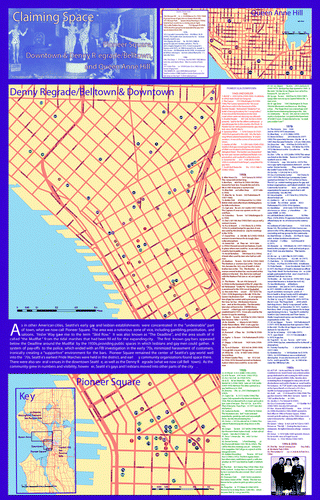
Figure 2 Side two of “Claiming Space.”
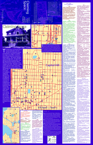
Table 1 Breakdown of sites by type Claiming Space 2004 map: Frequencies of type of site
Table 2 Frequencies of sites by decade 2004 map: Frequencies by decade
Table 3 Breakdown of sites by neighborhood 2004 map: Sites by neighborhood
To Make a Map: Ethnography
The Productive Tensions of Colliding Epistemologies
Given that the map project was guided by a queer epistemology and ontology, the project's constitutive politics necessarily reflected a process of negotiation and compromise with almost life-like forms of positivism, realism, pragmatism, and Cartesian rationality that insinuated themselves into the algorithms, hardware, and ongoing interpretation of our map production. In other words, a distinctly nonqueer epistemology infused the thinking of even ourselves and our nonacademic queer colleagues. Of course, the literature anticipated these forces (CitationAitken 2002; CitationSchuurman 2002a, Citation2006), but we were nevertheless struck by how vexing this problem was, and the degree to which it manifested itself even in discussions and decision making among group members ourselves.
Tensions appeared early. For example, early discussions among group members revolved around epistemological debates over deductive versus inductive orientations toward map-making. Initially, some members asserted that to be intelligible to the community, a single, a priori grand narrative was essential, and that our discussions should be focused on which story we wanted to adopt before any data collection could take place. The movement of gay space from Pioneer Square to Capitol Hill was one. Another was, “early on there was a small cluster of bars that constituted gay space, but over time sites queered, expanded, and diffused throughout the city as queer folk became more accepted” (i.e., CitationAtkins [2003] “from exile to belonging”). Others, ourselves included, tried to exemplify the queer theory and politics around us, and questioned the need for a predetermined narrative on the grounds that we did not wish to preclude new and multiple stories from emerging out of the map production process itself. We were at pains, for example, to include residential space from the pre-Stonewall era, on the grounds that private space was important in gay and lesbian lives, and because it was so hard to get from the archive. The importance of sites that were queered by sexual dissidents (like The Green Parrot, a second-run movie theater, or the Ben Paris lunch counter downtown) seemed impossible to ignore given queer historical geography's lessons, but they did not fit the teleological narrative. Our inductive position was driven by our motivation to uncloset queer space empirically and visually, at the same time retaining as much as possible a sense of the queerness of what we were representing (e.g., CitationSchuurman 2002b).
Amicable as these debates were, they were relentless, exhaustive, and time consuming. The problem, of course, is that data never only speak for themselves. Although arguably more multiple and diverse, the stories that emerged from the “winning” more inductive approach were still incomplete, imperfect, and somewhat chaotic. Still, we argued that our insistence on a more inductive practice would produce real-time reflexivity on both our parts and those of future map consumers about the many possible stories that the map might tell (or inspire). For example, areas of Seattle not typically thought of as queer, but with local concentrations of gay or lesbian residents or cruising areas at certain points in their histories, might be read as queer by individuals who lived the experience but were only dimly aware of their queer neighbors' presences and practices at the time, or others who, directly or indirectly, had occasion to brush up against these spaces.
There were also epistemological tensions around what was to constitute a site of significance, worthy of a dot on our map. Some members (not always the deductivists) argued for consistent and rigid criteria, on the grounds that such a practice would resolve in a more “professional” way the crisis of representation that we were confronting. Others (again, including ourselves) argued for more flexible and situational decision making. In still another axis of difference, the basis of significance for some members had to be public and documented, whereas for others it was more personal and affective. In the end our decisions were necessarily flexible and inconsistent, largely due to the free-wheeling, democratic, all-volunteer ethos of the History Project. Capitol Hill's City People's Hardware Store, for example, was included on the map largely because one member excitedly recalled how in the 1970s and 1980s it was one of the few hardware stores in which lesbians were treated with respect, and because it was one of the few cruising sites for lesbians on male-dominated Capitol Hill. Likewise, we included a dressmaker's studio from the early 1960s on Queen Anne Hill, because the owner advertised “drag a specialty,” but declined to include hairdressers and florists on Capitol Hill in the 1980s and 1990s on the grounds that they were too quotidian in that context.
Other issues pitting our queer theoretical orientation against a more orthodox scientific mind-set presented themselves at subsequent stages of the process. Data collection, cleaning, and coding were particularly complicated moments. They were shaped not only by pragmatic considerations but also issues of memory, negotiation, trust, and serendipity. For example, preliminary map drafts for internal consumption precipitated numerous discussions about point patterns that were emerging, and the kinds of locations that were and were not making their way onto the map. In some instances, such as gay-owned businesses without predominantly gay clienteles, this led to sites actually being removed. In others, though, it led to sites being added. For example, it was only after seeing a cluster of points around Queen Anne Hill that individuals remembered other locations nearby. Somewhat conversely, looking at the distribution of points citywide prompted some members to argue that certain neighborhoods they thought of as gay or lesbian should have some points on them. For example, Beacon Hill, a working-class neighborhood associated with Asian Americans, is currently known for its growing lesbian presence, so a great deal of research and debate went into figuring out if one of its taverns could legitimately be included on the map as a lesbian bar (the decision was, no). Similarly, these same patterns often just “looked wrong” to the group, which led to further discussions about induction versus deduction and the impact and importance of different types of locations (e.g., private residences versus businesses) vis-à-vis the visual pattern produced. The point here is not just that members had different and changing epistemological approaches to cartography, but that each of us “knew” the data differently (or even multiply). Epistemological tensions such as these are crucial to appreciate when understanding how the map was made.
Representing the Unrepresentable
A key issue in the queer historiography is the concern over imposing present-day categorizations of sexualities anachronistically on historical subjects who had no or different language for their positionality (CitationHalperin 2002). For us, the visceral experience of representing the historical geography of such subjects became a recurrent exercise in representing the unrepresentable. We were also reminded throughout the project of how difficult it can be to represent connectivity, fluidity, multiplicity, and multiple scales when making a simple two-dimensional map, especially given our rudimentary skills set. Although CitationSchuurman (2006) insists that both critical theorists and GISers deal equivalently with these vexations, our very uneven familiarity with both cannot be discounted here. We were struck by how productive these representational challenges turned out to be. This dilemma was a function not only of the queer subject matter, but also because of our own limits and ignorance about the technology and cartography.
As midcareer critical social theorists, neither of us had any substantial training in GIScience or graphic design software, though we both had some training in cartography. During this set-up period, then, Michael worked long hours on his own to learn the ArcGIS software, including especially its geocoding and address-matching functions. Both undergraduate and graduate students were especially generous and helpful with teaching and coaching along a very steep learning curve. Nonetheless, his very superficial and uneven knowledge of the GIS software and science meant that problems no doubt handily solved by GIS experts loomed very, very large for us. For example, some addresses from the 1930s and 1940s could not be reconciled with the software's current address-matching functions, were partial, or lacked the correct directional prefix or suffix, which is vital in the Seattle address system. Some parts of the city had been reassigned house numbers through the 1940s and 1950s. Interstate 5 had been built through the center of the city in the late 1950s, and this made some addresses anachronistic. Still another issue was the lack of a specific street address number for a specific site. Group members would often only be able to remember which block a site was on, or which side of the street it was on. Here, dummy addresses were assigned to estimate the actual location in Cartesian space. Where the historically correct address could not be matched, a dummy, proximate address was again used. A comment was added in the database noting the need for hand-correcting. Some nonpoint phenomena, such as gay pride parades and migration patterns, were left off the map altogether, due to the practical difficulty of accommodating them technologically (given our skills set at the time). These decisions, however imperfect, were part of the colliding epistemologies in the map's production.
In our attempt to represent the places behind (within?) the dotted locations, we used annotations and illustrations. They were our imperfect attempts to convey a sense of multidimensionality and contexts, as well as change and movement in sites, such as multiple private residences that functioned periodically as public meeting places. Images from The Garden of Allah (a downtown cabaret in the 1940s and 1950s) were selected in particular, for example, because they illustrated an underground closeted space in the basement of a downtown hotel that was also a nationally known hotspot for drag performers. Although a safe space for queer folks, it was also one that was popular with straights, who were welcome but expected to behave respectfully. The pictures were worth thousands of words.
We did not use complicated symbology to represent different types of locations, for two reasons. Sometimes we lacked the technical ability to do so, but more often we lacked precise information that complex symbols demand. For example, because of the Washington State Liquor Control Board's regulations, the distinction between a “bar” and a “tavern” was ontologically very important with respect to the visibility of the venue, and just what patrons could and could not do there (see CitationAtkins 2003 for more). We had very little reliable or consistent information on this important distinction. Likewise, some locations confounded easy categorization, as in the case of a 1970s gay-radio program that was broadcast from a home on north Capitol Hill. Furthermore, we wanted to avoid introducing more divisions and hierarchies into a set of phenomena that were in fact fluid and hybrid. Experiments with this option seemed to us to leave the map cluttered and overwritten. Many locations contained multiple and different sites over the years, and in fact evolved from one to the other rather than having hard edges or distinct moments of transformation. The inevitable essentializing that was done to fix these points in space, we hold, has led to a deeper appreciation among History Project volunteers in narrating such moving or contested sites on our simple map.
In trying to represent queer space fully on a two-dimensional map, we found ourselves forced to imagine the closet visually through different epistemologies simultaneously. In fact, as we discuss later, we and other group members were constantly frustrated by the fact that actual lived experiences included processes, practices, and experiences that were quite variable and unpredictable in both time and space. A good example here would be the Crescent Tavern, a bar known as either a lesbian or a gay bar, a bar known as homophobic or homosocial, and a space that was not simply one of many Capitol Hill drinking establishments, but the organizing site for the Lesbian Mothers National Defense Fund. The Garden of Allah, known for its drag shows was recalled as a site of police harassment and payoffs, although others knew it as “a home away from home,” a convivial closet space where female impersonators and same-sex affection were normal and affirmed. It was both closet space and public space simultaneously. Similarly, the act of visually claiming space that was otherwise unclaimed or deemed homophobic potentially misrepresented such spaces as queer-friendly. Golden Gardens and Woodland parks in North Seattle, for example, were subversive public–private situations for male–male sex, thus coded fondly and erotically. They were also known as places of fear, violence (as in gay bashing), and police harassment (CitationCastro 2006).
For the data we were mapping to be culturally resonant, we agreed to associate each site with only one decade in the annotation. This decision was a hugely nonqueer move, in that many sites actually spanned multiple decades and the construction of “decade” itself is quite obviously an artificial and particular reification of time. Yet that was how people recalled most sites. For example, Pioneer Square's The Double Header, frequently touted as the oldest continually operating gay bar in the United States,Footnote 6 was associated with the 1940s and earlier decades only, yet the bar is still open (although it now caters to a very different crowd), and still displays queer memorabilia from its heyday. We defend this move on the grounds that it allowed us to highlight the site's symbolic power, which is an exemplar of the constitutive politics underlying the project. In these ways, colliding epistemologies were not smoothly reconciled nor solved, and although they might be common problems in cartography, they productively resonated with our attempts to keep this a queer project.
Although annotations and illustrations were clearly imperfect solutions to the problem of representing queer spatialities, as CitationCameron and Gibson (2005) note, the plurality, diversity, and multitude of representations and perspectives that action-research empowers is itself a vital outcome, and one that we would argue reflects the democratic impulse behind so much of participatory GIS. Indeed, a key benefit of our participatory GIS approach was the efficient means by which multiple geographical imaginations and perspectives were “brought to the table” (CitationEsnard, Gelobter, and Morales 2004).
Productive Pragmatics
One of the things we find interesting about how all of these tensions were negotiated is the crucial and ironic role that pragmatics played in approaching, if not achieving, some of our more queer objectives. In turning “soft” data into “hard,” and acquiescing to our prior decisions about scope, scale, boundaries, and temporal categories (decades), we not only claimed space (literally) that was otherwise unclaimed or deemed homophobic, thereby securing a historical archive in the context of a community whose history is only just beginning to take material form, but actually helped facilitate the constitution of a queer political subjectivity. The map could also teach people who were on the scene but had their own situated knowledges. For example, more than one gay male baby boomer remarked that although the map makes him fondly recall Pioneer Square bars like Shelly's Leg, or Downtown's Dave's Steam Baths, it also made him realize just how much lesbian activism and culture occurred in the University District. Thus a key political outcome of the map was that it constituted a visible, historical, and tangible “we” that, ironically, included many different and evolving identities over time, precisely the point made by CitationNestle (1983). Similarly, when we show young queer Seattleites the map, many are astonished that there was a strong queer presence in Pioneer Square in the 1950s and earlier. The map draws a connection between queer life in Pioneer Square at the time that resembles hardly at all these young people's current “out of the closet” experience in neighborhoods like Capitol Hill. Today's Pioneer Square is a very heterosexualized and tourist-oriented historic district. The queer subjectivities we constituted through the map, then, were neither singular nor simply present, as in the case of so many identity-politics movements (CitationAitken and Michel 1995). They were multiple in their dimensions and spanned great distances in space and time. In other words, the map makes connections to be made between pre-Stonewall “closets,” post-Stonewall gay and lesbian “identities,” and contemporary queer “subjectivities.” Similarly, the crude temporal order that we imposed on our data, in combination with our fixing of the data as a collection of discrete sites, made vividly visible the movement of the largely closeted pre-Stonewall world of Pioneer Square to the contemporary gay (queer?) ghetto of Seattle's Capitol Hill neighborhood. We see on the map the explosion of sites over time, as well as their changing nature and location. The wonder, awe, and relief that the map elicits in viewers from all parts of the city and all walks of life suggests that it disrupts not just the heteronormativity of Seattle, but also its homonormativity (CitationSedgwick 1993), in particular the doxa that Capitol Hill is the fixed, spatial identity of queer Seattle. This surely evinces Kwan's (2007) emphasis on the affective power of geospatial technologies, for the way the map connects readers to either their own pasts, or something larger, is often quite an emotional experience of nostalgia, fondness, awe, and certainly pride.
We spent a considerable amount of time debating the map's scale and scope as well. Although there might be no such thing as scale (CitationMarston, Jones, and Woodward 2005), we had neither the time, skills, nor imagination to make a scaleless map. Still, we queerly achieve some of this spirit, by dividing the map into six subsets of different scales. In collision, however, was our ruthless decision to limit the map's scope to the city of Seattle itself, a decision that ran against our own writing on the need for queer geography to appreciate rurality (CitationKnopp and Brown 2003), and local evidence. Against so much of the urban bias in queer historiography, there are tantalizing bits of evidence throughout the twentieth-century Puget Sound region from rural and suburban queer folk. Somewhere in South King County, the 1960s fraternal organization Jamma Phi, as well as the sworn-to-secrecy Tamarack Society both held dances and picnics. For years there have been gay nude beaches near Olympia, Bellingham, and Edmonds. None of these made it onto our Seattle map. This acquiescence was a matter of our own technical limitations but also because a more regional scope would require so much assiduous archival and epistemological research that the map itself might never come to fruition.
There were also tensions between our vision and the map's audience that we actually hoped for, which remain productive. We tacitly imagined the map as a scholarly product, but more than one community member complained that the map should be large, single-sided, and at one scale so that it could be used as a poster in community and activist spaces. Still another complaint was that in high-tech Seattle, the map was anachronistically (“anachoristically”?) low-tech. The map should have been online, and interactive. We are very much drawn to this vision, but had no skills or resources to make it happen. Finally, as users interact with the map, they bring their own geographical imaginations to bear on ours. They correct our own errors (Freeway Hall's location is off by about 2,000 feet), point out omissions (we embarrassingly omitted the Ingersol Gender Center, despite the fact that one of our members is transgendered!), and use it for their own purposes (people have used the map as a contemporary local guide, which would work only imperfectly). Most resonantly, they add to our knowledge about these locations as places: they tell us their stories and thereby thicken our description of them. These productive pragmatics thus beget new knowledge: our knowledge of the map as it is now, and the map as it can be in its future permutations. With these errors and reactions, we must produce another, future version of the map.
A final instance of the productive nature of our pragmatics is the will to actually produce something, despite limited resources, imperfect knowledge, and a very informal and all-volunteer working environment. Making the map itself was important to the very ontology of the group. It gave us a clear focus, and its completion would bolster the group's sense of purpose and efficacy. Now to be sure, this claim for GIS's potential certainly does not inoculate us or the map from queer critique, perpetual and relentless as it always is. Nevertheless, for that critique to occur, the map had to be drawn in the first place. Yet we must also stress the counterfactual here: the alternative was to forego an important and practical form of visualization and representation (i.e., to not make the map). At this juncture, then, one might ask, is it irresponsible to be only queer? Should we also offer representations that are useful? And isn't the map itself a critique of the closeting of urban history, and of the heteronormative presumptions of urban geography more generally?
The Contingent Nature of Facts and Truth
Something that is hinted at on the map, but that is much better appreciated through the telling of this story about the making of the map, is the contingent and negotiated nature of facts and truth, and the productive work that such “facts” and “truths” enable the map to do. This point is akin to, but somewhat different, from CitationAitken and Michel's (1995) emphasis on the negotiation of the real in GIS planning. We of course tried to convey some of this contingency through annotations and illustrations, such as one explaining that “while Capitol Hill has become synonymous with the glbt community in Seattle, the map below shows we have always been everywhere in the city” and another describing one site's significance as having primarily to do with the fact that it is “fondly remembered.” However, the point became poignantly clear to us in the process of ground truthing and otherwise “cleaning” data, both before and after its publication. We found ourselves extraordinarily dependent on the memories of individual group members, and found how unreliable (but valuable) such imperfect memories can be. Nonetheless, such contingent memory is a vital—and sometimes the only—data we have to queer the historical geography of the closet (see also CitationAndrews et al. 2006). For example, one lesbian group member remembered a handful of communal lesbian houses scattered across the city in the 1970s but could not remember exactly where they were. In an attempt to include private residential spaces we prodded her to work through her own networks to find the actual addresses. She even went into the “field” to specify and ground truth her initially foggy memories. The truths the map told were contingent on her own positionality and demography, her own situated knowledge, the reactivation of her thirty-year-old friendship networks, not to mention her diligence.
More to the point, though, certain sites made their way onto the map—thereby becoming reified—whereas others did not, based solely, at times, on the fact that one or more of our members could confirm their existence (or their significance). Obviously this contingency implied another, namely that of who among us was present and who was not at a particular meeting. Compounding the issue was the fact that different members had different sentimental attachments or other personal interests in seeing certain sites on the map. The result was a process of discussion and negotiation that yielded highly contingent decisions, at times, about what ended up being represented and what did not. Although this partiality might be seen, according to traditional social scientific rules and conventions, as little more than a flaw, the fact is that these same memories, discussions, and negotiations almost certainly stimulated memories and imaginations as much as occluding them. The effect of that, once map viewers get involved, is cumulative. Yes, certain sites did not find their way onto the map, due to lack of memory or advocacy on the parts of group members. It is also likely that some sites provided by single-source data providers (i.e., one member of the group) could be mistakes. However, many, many more found their way onto the map that clearly deserved to, due to the collective process involved. Still more enter the public domain as map viewers and critics interact with and discuss the map.
Still another contingent basis for facts and truth emerged because we are an all-volunteer organization. We cannot ignore the simple fact that reminiscing, memory work is a vital source of data (e.g., CitationGrasseni 2004) but it was always contingent on who was a member of the History Project, and whether or not they showed up to meetings at which discussions and decisions took place that year. Structurations of class, race, and gender among all of us volunteers also contingently affected the information on the map. Very little on the map speaks to the experiences of nonwhite and other ethnic minority queer people. In Seattle, there remains much to be uncovered about the historical geographies of queer African Americans, Asian Americans, and native people, in particular. Clearly the map's relative silence on these groups had a great deal to do with the fact that our group was overwhelmingly white, and a suspicion on the part of elderly queers of color toward such a white organization. Few of us had any memories of our own to offer in this regard, nor much in the way of access to other appropriate sources of data. Somewhat conversely, the working-class experience of most of our older volunteers means that we have very little detailed annotation on upper class organizations, like the Etruscans, or cruising areas in downtown high-end hotels. The map is, of course, the worse for it, but these omissions and underrepresentations (and the reasons for them) are noted in all of our presentations about the map, and have produced reactions, corrections, and insights from map viewers.
Similarly, over half the sites represented on the map were allocated to the 1970s or before, despite the fact that the 1990s and 2000s were periods of unprecedented growth in queer institutions and spaces in the city (see ). In one respect this bias toward the past is an artifact of our stated mission of producing a map of Seattle's queer historical geography. Even if our mission had been less historical, however, the increasing mainstreaming of queer cultures in contemporary Seattle has made defining and distinguishing what is queer and what is not extraordinarily difficult. Does a live music venue that regularly has “queer nights” count, especially when others that do not might be equally known and understood locally as queer (or at least queer-friendly)? What about a progressive but non-queer-identified organization (such as the ACLU) whose political agenda foregrounds queer issues more aggressively than some gay and lesbian organizations of the 1960s or 1970s? If many of the thresholds we implicitly used to include sites from the 1940s, 1950s, and 1960s were adhered to in evaluating sites from the 1990s and 2000s, the map could easily send the message that most of Seattle is queer space! And isn't that contrast, between the lived experience of contemporary queerness and the map's representation of it historically, part of its power?
This issue of “truth” was manifest in at least one other, even more surprising way. Much to his surprise—although perhaps not to CitationAitken and Michel (1995)—Michael found himself cast as the local expert on the University of Washington campus on the issue of address matching. Although others with more refined expertise than he vis-à-vis software and data structures helped, no one could be found either in his own geography department or any other department on campus who was familiar with the peculiarities of the Seattle street grid and street numbering system (including its changes over time) and the particular software being used to produce the map. So his own pragmatic interpolations, extrapolations, and speculations at times became the “truth” about where certain addresses—especially those that no longer exist—“really” were. Even though it produced a series of “truths” that were, arguably, “Michael-specific,” this casting of Michael as address-matching expert clearly means that future consumers of his protocols will be reproducing, in some small and possibly not-so-small ways, his queer imagination in their work.
Power and Its Discontents
Finally, with respect to colliding epistemologies and the productive tensions associated with them, we became very aware of the importance of various forms of power in this knowledge-production process. Again, this is less immediately visible on the map than it is a product of the map production process. But it is still both.
Our own authority in the History Project as “the geographers,” and Michael's as “the technician,” were particularly important. We were interpellated by our compatriots in a way that gave us a certain amount of freedom that others did not enjoy. Naturally this was uncomfortable for us, but in certain ways it facilitated production of the map. In one obvious and profoundly consequential way it allowed us to use our academic credentials and institutional resources to secure funding and research assistant support, as well as access to software. At the same time, others in the group had postgraduate credentials as well (specifically in history, planning, and anthropology). And although CitationNorheim (2004) has underscored the importance of institutional culture in affecting GIS, we found that the clashes of academic and intellectual cultures that sometimes emerged (for example, one urban planner's impulse to approach the map with an a priori story versus our own more inductive impulses) led to enormously productive debates and negotiations, and a map that tells multiple stories from different vantage points.
A certain amount of authority was also ceded, out of respect, to older members of the group and to Seattle natives (several of whom were the same people). However, this authority was tempered by the simple needs of younger and nonnative members to have certain things explained to them. The act of explaining led, at times, to a critical reevaluation of elders' or natives' own uncritically examined lore, which then changed how (or if) a site was represented or annotated on the map. For example, the emergence of Capitol Hill as the protean gay ghetto in the 1970s and 1980s was often explained voluntaristically, with young-boomer gay men willfully flocking to the affordable, high-density rental properties in that central neighborhood. We challenge that spatial story, raising questions about white flight, gentrification, and the invisibility of lesbians in this narrative.
Still another form of structural power we acknowledge is that of the market relations within which software developers, printers, and we were embedded. Although it is difficult to see these structures of power as productive, given the emancipatory purpose of the map, we recognize that our relatively privileged positions within these structures—both in terms of economic class and professional status—has contributed mightily to our ability to get the job done. For example, we were dissuaded from applying for federal or even private grant money, given the controversial nature of the subject matter. Indeed, this kind of project has been dismissed as too controversial for external funds. The Arcus Foundation Grant itself only paid for printing costs. Had we access to more resources, some of the maps' limitations might have been surpassed.
Conclusion: Ethnography and Uncloseting the Queerness of Map Production
The key point about the productive nature of all of the tensions and problems involved in the map's production, as we see it, is not that they resulted in some kind of consensus (CitationKyem 2004) or reconciliation (CitationSchuurman 2002a). They were not simply technical problems, nor were they just opportunities for queer rumination. Rather it is that they opened the process of map production and consumption to multiple forms of representation, multiple ways of knowing, and multiple interpretations. No single notion of “queer” made its way onto the map nor does the map exclude all but a narrow range of readings. It is far from all things to all people, but it is most certainly not a singular rendering of Seattle's queer historical geography. Still, absent this ethnographic reflection on its production, the map, due to its own physical, visual, technical, and technological reifications, closets the queerness of that production.
We conclude this article by speaking back to the literatures that inspired our project, as well as some broader points to the discipline overall. To queer urban history and geography, and the broader world of sexuality and space studies, we hold that GIS can be an integral part of a politics of uncloseting urban (and other) spaces that are otherwise heteronormatively represented and imagined. By fixing and making visible queer spaces and places—particularly from the past—a constitutive politics of individual and collective identity, community, history, and belonging is made possible. Moreover, seemingly fixed visual representations, such as those on our map, might in fact be both derivative and productive of much more queer spatialities and knowledges. The intellectual, political, and cultural work that making the map entailed, and that its existence continues to inspire, makes this clear. Despite their seemingly built-in epistemologies and ontologies, cartography and GIS did not dictate our own epistemologies and ontologies. As Sieber (2000) would predict, there were some conforming properties to our GIS, but there were also resistances. Our multiple subject positions demonstrated this point, as does the fact that we used GIS technologies and algorithms productively to do much more than just map points in space. Moreover, the reflexivity brought out in this ethnography is a key step in achieving the cyborg hybridity that feminist GIS envisions. Surely the map's own colliding epistemologies evince a queer sensibility, no matter how Cartesian the artifact!
Anticipating the reaction of the GIS community to this article, one reviewer suggested that “those who are less predisposed to critical and queer theory will remain unconvinced that there is anything of worth here.” We question in reply: then why have they not made this map already? Might it have something to do with structures of homophobia and heteronormativity, or their own ignorance of queer lives? Queer theory is not simply about destabilizing epistemologies and ontologies; it is also about pointing out how normal and neutral forms of representation insidiously closet queer folk. Simply put, you cannot just add gay and then lesbian layers to your shapefile.
To the worlds of feminist, critical, and participatory GIS we note that although a recent exciting focus has been on integrating feminist and postcolonial questions into research agendas, queer realities cannot just be ignored or subsumed into those projects. Queer identities and political histories are unique and worthy of their own careful attention (CitationSchuurman and Pratt 2002). Furthermore the political valence of participatory GIS can be extended beyond distributional issues. “Claiming Space” was part of a constitutive, not just distributional or oppositional, politics. The visual artifact itself (the map) and what happened around it were both important. The map not only relied on but produced—and continues to produce—new and different kinds of knowledge, by affirming identities, sparking imaginations, and inspiring activism.
We also note that collisions between the epistemologies underlying our critical and ethnographic methods and epistemologies more easily (and typically) anticipated by GIS technologies, were absolutely crucial moments in our process. These moments facilitated the production of multiple and hybrid forms of data that were then translated into fixed points on the map. So in this case GIS, rather than necessarily privileging certain kinds of knowledge and data over others, in fact mediated between epistemologically and ontologically dissonant ways of knowing.
The tensions and conflicts that we describe here were just that; they were not simple or easy moments of harmony or reconciliation or commensuration. GIS empowered and marginalized, as T. CitationHarris and Weiner (1998) note, but so too did the social and archival work around it (CitationAndrews et al. 2006). It is important, then, to pay close attention to these kinds of tensions and conflicts, reflexively, in any critical GIS research project, especially those that self-consciously seek to join GIS and social theory through hybridity, connections, or “writing the cyborg.” Inevitably, there will be compromises that have to be made, contradictions that have to be lived with, and rubicons that cannot be crossed. Coming clean about these limits, compromises, and contradictions is integral to the project of merging queer geography and cartography/GIS.
To the discipline more broadly, we close with two points: First, the worlds of GIS and queer geography can work together productively, albeit with limits and certainly tensions and dissonance, to advance geographic research that is “relevant.” In this regard we follow CitationStaeheli and Mitchell (2005), who insist that how the discipline defines relevance must be an open question. The relevance of “Claiming Space” was never primarily policy oriented nor conceived as a tool to redistribute resources. Its relevance was constitutive: to claim sexuality and space as an urban historical geography, and to say, vividly and visually, “The city is our space, too” (CitationWick 2004, 1).That form of intervention—in the political context of an epistemology of the closet—surely is a powerful form of relevance.
Second, our project speaks to the perennial laments about the allegedly increasing splintering and centrifuge in the discipline. Queer geography has been held up as one example of geographers straying too far from the discipline's hearth and ken. Indeed, another sympathetic referee (of our manuscript submission) ironically ordered, “the title is only going to appeal to a slim audience. Change it.”Such arguments typically come from—and empower—those at the historical core of the discipline, who demand a narrow epistemological and methodological orthodoxy as the means to reintegrate the discipline's factions. On the contrary, our project demonstrates that an epistemologically plural approach is possible (and perhaps even desirable), but from a perspective that embraces tensions and conflicts as opportunities to advance knowledge, rather than viewing them as obstacles.
Acknowledgments
We thank the Arcus Foundation for supporting this project. Thanks also to our fellow volunteers at the Northwest Lesbian and Gay History Museum Project for their inspiration, friendship, and labor. Four anonymous referees and especially the editor, Mei-Po Kwan, provided very helpful comments on an earlier draft of the article. Finally we thank Sarah Elwood, Tim Nyerges, Dick Morrill, Matt Wilson, Chris Philo, and Kevin Ramsey for feedback and support at various stages of the article's preparation.
Notes
1 The Northwest Lesbian and Gay History Museum Project (http://home.earthlink.net/∼ruthpett/lgbthistorynw/) is an organization in Seattle (part of Gay Community Social Services) that collects, interprets, and disseminates queer history for education and enjoyment.
2 Previously, the United States' National Gay and Lesbian Task Force had unveiled a series of “issue maps” on its Web site (http://www.thetaskforce.org/reslibrary/list.cfm?pubTypeID=1). These are very conventional national and state-level maps of gay, lesbian, bisexual, and transgender people's statuses under various aspects of state and local law in the United States. However the site includes at least one laudable (if rather crude) effort to engage in analysis as well: a map titled “The Link Between Ex-Gay Conferences and Anti-Gay Ballot Measures.”
3 Although in Matthews, Detwiler, and Burton's project, ethnography was a part of a data-collection strategy alongside GIS analysis. Here we turn ethnography back onto the GIS project itself.
4 Although our goal was a (deceptively) simple cartographic product rather than a detailed spatial analysis using GIS, we did so within the strictures and protocols of a GIS. Hence we contend that our project lies at the intersections of queer geography and GIS, not just queer geography and cartography. The importance of working between queer geography and GIS is evident in the fact that in one of our departments, undergraduates often draw an incorrect, yet very sharp and antidistinction between those who “do GIS” and those who “do critical theory,” much to the frustration of faculty. This project thus became one means to performatively disrupt such unhealthy impermeable borders in departmental culture.
5 The Arcus Endowment, administered by the College of Environmental Design at the University of California, Berkeley supports “a wide range of critical activities that explore the relationship between gender, sexuality and the built environment” (http://www.ced.noexpandberkeley.edu/prizesstring_awards/arcaward/webArcusstring_Awardsstring_2003Application20Information.pdf). One of the three themes being funded that year was “mapping histories of queer space.”
6 See Atkins (2003) for details on the Double Header. For an alternate claim on the oldest bar in the U.S., see http://www.advocate.com/news_detail_ektid35694.asp.
Related Research Data
References
- Adobe InDesign, Version 3.0.1 , Seattle, WA : Adobe .
- Aitken , S. 2002 . “ Public participation, technological discourses and the scale of GIS ” . In Community participation and geographic information systems , Edited by: Craig , W. , Harris , T. and Weiner , D. 357 – 66 . New York : Taylor & Francis .
- Aitken , S. and Michel , S. 1995 . Who contrives the “real” in GIS?: Geographic information, planning, and critical theory . Cartography and Geographic Information Systems , 22 : 17 – 29 .
- Andrews , G. , Kearns , R. , Kontos , P. and Wilson , V. 2006 . Their finest hour: Older people, oral histories, and the historical geography of social life . Social and Cultural Geography , 7 : 153 – 77 .
- ArcGIS, Version 8.1 , Olympia, WA : ESRI .
- Atkins , G. 2003 . Gay Seattle: Stories of exile and belonging , Seattle : University of Washington Press .
- Baker , A. 2003 . Geography and history: Bridging the divide , Cambridge, U.K. : Cambridge University Press .
- Binnie , J. 1995 . Coming out of geography: Towards a queer epistemology . Society and Space , 15 : 223 – 37 .
- Binnie , J. and Skeggs , B. 2004 . Cosmopolitan knowledge and the production and consumption of sexualized space . The Sociological Review , 52 : 39 – 61 .
- Binnie , J. and Valentine , G. 1999 . Geographies of sexuality: A review of progress . Progress in Human Geography , 23 : 175 – 87 .
- Boyd , N. A. 2003 . Wide open town: A history of queer San Francisco to 1965 , Berkeley : University of California Press .
- Brickell , C. 2000 . Heroes and invaders: Gay and lesbian pride parades and the public/private distinction in New Zealand media accounts . Gender, Place and Culture , 7 : 163 – 78 .
- Brown , M. 1995 . Ironies of distance: An ongoing critique of the geographies of AIDS . Society and Space , 13 : 159 – 83 .
- Brown , M. 2000 . Closet space: Geographies of metaphor from the body to the globe , London : Routledge .
- Brown , M. and Knopp , L. 2006 . Places or polygons?: Governmentality, scale, and the census in The Gay and Lesbian Atlas . Population, Space and Place , 12 : 223 – 42 .
- Brown , M. , Knopp , L. and Morrill , R. 2005 . The culture wars and urban electoral politics: Sexuality, race, and class in Tacoma, Washington . Political Geography , 24 : 267 – 91 .
- Brown , M. and Staeheli , L. 2003 . Are we there yet? Feminist political geography . Gender, Place and Culture , 10 : 247 – 55 .
- Browne , K. 2006 . Challenging queer geographies . Antipode , 38 : 885 – 93 .
- Cameron , J. and Gibson , K. 2005 . Participatory action research in a poststructuralist vein . Geoforum , 36 : 315 – 31 .
- Carter , D. 2004 . Stonewall: The riots that sparked the gay revolution , New York : St. Martin's .
- Carver , S. 2003 . The future of participatory approaches using geographic information: Developing a research agenda for the 21st century . URISA Journal , 15 : 61 – 71 .
- Castells , M. 1983 . The city and the grassroots , Berkeley : University of California Press .
- Castro , H. 2006 . 4 arrested at park restroom Seattle Post-Intelligencer, 17 August, B2
- Chauncey , G. 1994 . Gay New York: Gender, urban culture, and the making of the gay male world , New York : Basic Books .
- Cieri , M. 2003 . Between being and looking: Queer tourism promotion and lesbian social space in greater Philadelphia . Acme , 2 : 147 – 66 .
- Crampton , J. 2004 . GIS and geographic governance: Reconstructing the choropleth map . Cartographica , 39 : 41 – 53 .
- Elder , G. 2003 . Hostels, sexuality, and the apartheid legacy , Athens : Ohio University Press .
- Elkin , S. 1985 . Economics and political rationality . Polity , 18 : 253 – 71 .
- Elwood , S. 2002 . GIS use in community planning: A multidimensional analysis . Environment and Planning A , 34 : 905 – 22 .
- Elwood , S. 2006 . Beyond cooptation or resistance: Urban-spatial politics, community organizations, and GIS-based spatial narratives . Annals of the Association of American Geographers , 96 : 323 – 41 .
- Esnard , A. , Gelobter , M. and Morales , X. 2004 . Environmental justice, GIS, and pedagogy . Cartographica , 38 : 53 – 61 .
- Fyfe , N. and Milligan , C. 2003 . Out of the shadows: Exploring contemporary geographies of voluntarism . Progress in Human Geography , 27 : 397 – 413 .
- Gates , G. and Ost , J. 2003 . The gay and lesbian atlas , Washington, DC : The Urban Institute .
- Gorman-Murray , A. 2006 . Homeboys: Uses of home by gay Australian men . Social and Cultural Geography , 7 : 53 – 69 .
- Grasseni , C. 2004 . Skilled landscapes: Mapping practices of locality . Society and Space , 22 : 699 – 717 .
- Halperin , D. 2002 . How to do the history of homosexuality , Chicago : University of Chicago Press .
- Hanson , S. 2002 . Connections . Gender, Place and Culture , 9 : 301 – 3 .
- Harris , C. 1992 . Power, modernity and historical geography . Annals of the Association of American Geographers , 81 : 671 – 683 .
- Harris , T. and Weiner , D. 1998 . Empowerment, marginalization, and “community-integrated” GIS . Cartography and Geographic Information Systems , 25 : 67
- Harvey , F. 2000 . The social construction of geographical information systems . International Journal of Geographical Information Science , 14 : 711 – 13 .
- The History Project . 1998 . Improper Bostonians: Lesbian and gay history from Puritans to playland , Boston : Beacon Press .
- Hoelscher , S. and Alderman , D. 2004 . Memory and place: Geographies of a critical relationship . Social and Cultural Geography , 5 : 347 – 55 .
- Holdsworth , D. 2003 . Historical geography: New ways of imagining and seeing the past . Progress in Human Geography , 27 : 486 – 93 .
- Hornsey , R. 2002 . The sexual geographies of reading in post-war London . Gender, Place and Culture , 9 : 371 – 84 .
- Houlbrook , M. 2005 . Queer London , Chicago : University of Chicago Press .
- Hubbard , P. 1998 . Sexuality, immorality, and the city . Gender, Place and Culture , 5 : 55 – 72 .
- Hubbard , P. 2001 . Sex zones: Intimacy, citizenship, and public space . Sexualities , 4 : 51 – 71 .
- Hubbard , P. 2002 . Sexing the self: Geographies of engagement and encounter . Social and Cultural Geography , 3 : 365 – 81 .
- Jankowski , P. and Nyerges , T. 2001 . Geographic information systems for group decision making , New York : Taylor & Francis .
- Krahulik , K. C. 2005 . Provincetown: From Pilgrim landing to gay resort , New York : New York University Press .
- Knopp , L. 1996 . Lost space(s) in George Chauncey's Gay New York . Society and Space , 14 : 759 – 61 .
- Knopp , L. 2004 . Ontologies of place, placelessness, and movement: Queer quests for identity and their impacts on contemporary geographic thought . Gender, Place and Culture , 11 : 121 – 34 .
- Knopp , L. and Brown , M. 2003 . Queer diffusions . Society and Space , 21 : 409 – 24 .
- Kwan , M.-P. 2002a . Feminist visualization: Re-envisioning GIS as a method in feminist geographic research . Annals of the Association of American Geographers , 92 : 645 – 61 .
- Kwan , M.-P. 2002b . Is GIS for women?: Reflections on the critical discourse in the 1990s . Gender, Place and Culture , 9 : 271 – 79 .
- Kwan , M.-P. 2004 . Beyond difference: From canonical geography to hybrid geographies . Annals of the Association of American Geographers , 94 : 756 – 63 .
- Kwan , M.-P. 2007 . Affecting geospatial technologies: Towards a feminist politics of emotion . The Professional Geographer , 59 : 22 – 34 .
- Kyem , P. 2004 . Of intractable conflicts and participatory GIS applications: The search for consensus amidst competing claims and institutional demands . Annals of the Association of American Geographers , 94 : 37 – 57 .
- Lapovsky-Kennedy , E. and Davis , M. 1993 . Boots of leather, slippers of gold , New York : Routledge .
- Marston , S. , Jones , J. P. and Woodward , K. 2005 . Human geography without scale . Transactions of the Institute of British Geographers , 30 : 416 – 35 .
- Matthews , S. , Detwiler , J. and Burton , L. 2005 . Geo-ethnography: Coupling geographic information analysis techniques with ethnographic methods in urban research . Cartographica , 40 : 75 – 90 .
- McCourt , J. 2004 . Queer street: The rise and fall of an American culture , New York : Norton .
- McLafferty , S. 2002 . Mapping women's worlds: Knowledge, power and the bounds of GIS . Gender, Place and Culture , 9 : 263 – 69 .
- Minnesota Geography Reading Group . 1996 . Review of Gay New York: Gender, urban culture, and the making of the gay male world, 1890–1940 by George Chauncey . Gender, Place and Culture , 3 : 95 – 101 .
- Moran , L. 1998 . Legal queeries , London : Cassell .
- Morgan , M. 1982 . Skid road , Seattle : University of Washington Press .
- Mort , F. 2000 . Dangerous sexualities: Medico-moral politics in England since 1830 , London : Routledge .
- Nash , C. J. 2006 . Toronto's gay village (1969–1982): Plotting the politics of gay identity . The Canadian Geographer , 50 : 1 – 16 .
- Nestle , J. 1983 . Voices from lesbian herstory . The Body Politic , 96 : 35 – 36 .
- Newton , E. 1993 . Cherry Grove, Fire Island: Sixty years in America's first gay and lesbian town , Boston : Beacon Hill Press .
- Norheim , R. 2004 . How institutional culture affects results: Comparing two old-growth forest mapping projects . Cartographica , 38 : 35 – 52 .
- Northwest Lesbian and Gay History Museum Project . 2002 . Mosaic 1: Life stories—From isolation to community , Seattle, WA : Northwest Lesbian and Gay History Museum Project .
- Obermeyer , N. 1998 . The evolution of public participatory GIS . Cartography and Geographic Information Systems , 25 : 65 – 66 .
- O'Reilly , K. and Crutcher , M. 2006 . Parallel politics: The spatial power of New Orleans's Labor Day parades . Social and Cultural Geography , 7 : 245 – 65 .
- Oswin , N. 2005 . Researching “gay Cape Town,” finding value-added queerness . Social and Cultural Geography , 6 : 567 – 86 .
- Parker , B. 2006 . Constructing community through maps? Power and praxis in community mapping . The Professional Geographer , 58 : 470 – 84 .
- Pavlovskaya , M. 2002 . Mapping urban change and changing GIS: Other views of economic restructuring . Gender, Place and Culture , 9 : 281 – 89 .
- Perkins , C. 2003 . Cartography: Mapping theory . Progress in Human Geography , 27 : 341 – 51 .
- Philo , C. 1994 . “ History, geography, and the still-greater mystery of historical geography ” . In Human geography: Society, space, and social science , Edited by: Gregory , D. 252 – 81 . Minneapolis, MN : University of Minneapolis Press .
- Pickles , J. 2004 . A history of spaces: Cartographic reason, mapping, and the geo-coded world , London : Routledge .
- Podmore , J. 2001 . Lesbians in the crowd: Gender, sexuality, and visibility along Montreal's Boul. St-Laurent . Gender, Place and Culture , 8 : 333 – 55 .
- Podmore , J. 2006 . Gone underground?: Lesbian visibility and the consolidation of queer space in Montreal . Social and Cultural Geography , 7 : 595 – 625 .
- Rundstrom , R. 1995 . GIS, indigenous peoples, and epistemological diversity . Cartography and Geographic Information Systems , 22 : 45 – 57 .
- Schuurman , N. 2002a . Reconciling social constructivism and realism in GIS . ACME , 1 : 73 – 90 .
- Schuurman , N. 2002b . Women and technology in geography: A cyborg manifesto . The Canadian Geographer , 46 : 258 – 65 .
- Schuurman , N. 2004 . GIS: A short introduction , Oxford, U.K. : Blackwell .
- Schuurman , N. 2006 . Formalization matters . Annals of the Association of American Geographers , 96 : 726 – 39 .
- Schuurman , N. and Pratt , G. 2002 . Care of the subject: Feminism and critiques of GIS . Gender, Place and Culture , 9 : 291 – 9 .
- Sedgwick , E. 1990 . Epistemology of the closet , Berkeley : University of California Press .
- Sedgwick , E. 1993 . Tendencies , Chapel Hill, NC : Duke University Press .
- Sieber , R. E. 2000 . Conforming (to) the opposition: The social construction of geographical information systems in social movements . International Journal of Geographical Information Science , 14 : 775 – 93 .
- Sparke , M. 1998 . “ Mapped bodies and disembodied maps ” . In Places through the body , Edited by: Nast , H. and Pile , S. 305 – 37 . London : Routledge .
- Staeheli , L. and Mitchell , D. 2005 . The complex politics of relevance in geography . Annals of the Association of American Geographers , 95 : 357 – 72 .
- Stein , M. 2004 . City of sisterly and brotherly loves: Lesbian and gay Philadelphia 1945–1972 , Philadelphia : Temple University Press .
- Stryker , S. and Van Buskirk , J. 1996 . Gay by the bay: A history of queer culture in the San Francisco Bay area , San Francisco : Chronicle Books .
- Valentine , G. 1993 . (Hetero)sexing space: Lesbian perceptions and experiences of everyday spaces . Society and Space , 11 : 395 – 413 .
- Valentine , G. and Skelton , T. 2003 . Finding oneself, losing oneself: The lesbian and gay “scene” as a paradoxical space . International Journal of Urban and Regional Research , 27 : 849 – 66 .
- Wick , N. 2004 . Geographer puts gays, lesbians on the map: The city is our space too University Week, 22 July, 1
- Wong , B. 2004 . Seattle's gays and lesbians put themselves on the map Seattle Post-Intelligencer, 7 July, B3
- Wood , D. 1992 . The power of maps , New York : Guilford .