Abstract
Geographic information system (GIS) technology fundamentally changes how information is viewed, literally, for its maps and databases contain uncertainty, assumptions, privileged knowledge, and story-making power, along with unintended social consequences. This article hypothesizes that the introduction of GIS into the public participation process in natural resource management blurs the boundaries between science and nonscience, requiring a revision of the way we think about, learn from, and use maps for environmental decision-making. This may lend a degree of “social power” to nonscientists in the form of providing improved access to data and maps, and along with it the resulting expression of community needs, priorities, and goals, with perhaps the “power” to influence policy and management decisions. A case study from western Oregon forest management provides context and practical examples. We consider, through a broad conceptual discussion, how GIS technology might contribute to, or detract from, confrontational environmental policy discussions, in particular the process of designing and structuring decision problems. In natural resource management this has tended to be a largely science-driven exercise at the expense of input from nonscientific stakeholders. Our case study findings suggest that using GIS can, with time, open the door to making environmental assessments more collaborative, story-making processes, with implications for natural resource management of many kinds. Although epistemological and power differences between scientists and lay audiences remain, they can be offset through various kinds of collaboration. Such efforts could contribute to a new phase in technology diffusion that we call development of faith.

La tecnología de los sistemas de información geográfica (SIG) cambia fundamentalmente la manera como se ve la información, literalmente, puesto que sus mapas y bases de datos contienen incertidumbre, supuestos, conocimiento privilegiado y poder de hacer historia, junto con consecuencias sociales imprevistas. A este artículo lo guía la hipótesis de que la introducción de los SIG en los procesos de participación pública en el manejo de recursos naturales hace menos claros los límites entre ciencia y ficción, demandando una revisión del modo como usamos, interpretamos y evaluamos los mapas, en términos de la toma de decisiones ambientales. Esto puede dar cierto grado de “poder social” al lego al suministrarle acceso mejorado a datos y mapas, y junto con eso entidad a la expresión resultante de necesidades comunitarias, prioridades y metas, quizás con el “poder” de influir sobre decisiones de políticas y manejo. Un estudio de caso correspondiente al manejo de bosques del occidente de Oregón provee contexto y ejemplos prácticos. Mediante amplia discusión conceptual, consideramos cómo la tecnología SIG podría contribuir en las discusiones de política ambiental controversial, o restarle valor, en particular lo relacionado con el proceso de diseñar y estructurar problemas de decisión. En el manejo de recursos naturales la tendencia ha sido convertir esto en un ejercicio orientado por la ciencia en detrimento del aporte que podría provenir de otros interesados no científicos. Los descubrimientos de nuestro caso estudiado sugieren que la utilización de los SIG puede con el tiempo abrir puertas que conviertan la evaluación ambiental en procesos más colaborativos y trascendentes, con implicaciones para el manejo de recursos naturales de muchas clases. Aunque subsistan diferencias epistemológicas y de poder entre audiencias de científicos y legos, aquéllas podrán ser limadas mediante varios tipos de colaboración. Tales esfuerzos podrían contribuir a una nueva fase de difusión de tecnología a la que llamamos desarrollo de fe.
Public participation in natural resource decisions has been steadily increasing in the United States since the National Environmental Policy Act (NEPA 2007) was first signed into law in 1970, thus formalizing it as a requirement of policy making on public lands. Subsequent litigation has demonstrated that angry or even just concerned citizens can effectively shut down public resources if they feel their input has not adequately been heard. More recently, the spread of the watershed council movement (comprised of local citizen volunteers working with local and state governments) and of other kinds of conservation and restoration efforts has increased the involvement of nonscientists in the management of natural resources. Simultaneous with these key developments, GIS technologies have opened potentials for new ways of considering landscapes, ranging from highly technical data analysis by scientists to highly collaborative nonscientist stakeholder input into design of environmental assessments. Some authors have discussed whether this has lent a degree of “social power” to nonscientists in the form of providing improved access to data and maps, and along with it the resulting expression of community needs, priorities, and goals, with perhaps the “power” to influence policy and management decisions (e.g., CitationHarris and Weiner 1998; CitationGhose 2001; CitationElwood 2006a; CitationSchuurman 2006; CitationSieber 2006). Indeed, the shaping of a map, including its assumptions, uncertainty, and fuzziness, naturally involves human decisions and is thus a locus of social power, even if the individuals involved are essentially blind to or uninterested in that power (CitationRappert 2001; CitationRohracher 2003).
In this article, the working hypothesis is that the introduction of geographic information system (GIS) technology into the ancient procedures of mapmaking has changed the mapmaking context by blurring the boundaries between science and nonscience to such a degree that it requires a revision of the way we think about, learn from, and use maps, specifically in the public involvement process in natural resource management (NRM). It is suggested that most people still assume they jointly know what maps mean, what they do, and how to use them. This assumption needs careful revision in the rapidly changing arena of digital, information-dense, and highly technical mapmaking, replete with new levels of uncertainty and assumption, not least because the social context for environmental policy-making has undergone significant upheaval in the United States in the last quarter century and faces continual change and development elsewhere. We do not mean to imply that GIS is comprised solely of “map-making,” but this is the critical component of GIS that we focus on in this article.
Given that more and more is to be expected of GIS maps—as tireless analysts and flexible displayers of exponentially expanding natural resource databases, as purveyors of technical information to nontechnical audiences, as untried bridges between rival epistemologies, as proxy storytellers—the technology behind them represents a useful focal point for considering the interacting matters of science, NRM, and public involvement. GIS maps have usefully been portrayed as the graphical tip of the GIS technology iceberg (CitationSchuurman 1999), and until we can be comfortable with both the technical aspects and the social implications embedded in the technology, its most prolific outputs—the maps—could indeed continue to obscure as much as they illuminate.
Key research questions, therefore, are as follows: (1) How can GIS maps contribute to mutual learning in the NRM arena? (2) Can GIS technology and its diffusion play a transformative role in NRM? (3) How are the properties of public interaction—power imbalances, trust, even forces for social change—affected when GIS technology is engaged? We use an exploratory case study from western Oregon to address these questions, namely the Coastal Landscape Analysis and Modeling Study (CLAMS), a coarse, regional-scale bioregional assessment that draws heavily on GIS technology to illustrate ecological and socioeconomic dynamics and interactions. The main goal of this continuing project is to analyze through time the varying consequences of forest management policies across different levels of land ownership (private, industrial, state, federal) and land use categories (e.g., residential, public lands, timber harvesting, recreational, habitat conservation; CitationSpies et al. 2007). CLAMS encompasses the Oregon Coast Range Province, a 5-million-acre area stretching from the northern border of Oregon, almost to its southern border with California, and west from the crest of the Coast Range to the Pacific Ocean. Combining data collection from remote sensing and field plots, the CLAMS science team has developed multiple models and displays much of its data in the form of GIS maps (please see CLAMS 2007 for displays of full GIS products).
As an anticipatory bioregional assessment (projecting potential outcomes of various management policies out as far as 100 years), the CLAMS project provides a unique opportunity to examine the utility of an emerging technology as it is coupled to an emerging resource management philosophy. In fact, a CLAMS principal investigator has noted, “We have hit the wall in terms of pushing our spatial analysis into the public policy arena until we work out the understandability and usability issues surrounding our maps and tools” (T. A. Spies, personal communication, 15 July 2004).
The case study was therefore designed to illuminate potential misunderstandings and misuses of GIS maps as presentation devices and communication tools in public settings. For the purposes of this article, “scientists” are defined broadly as those who actively engage in ecological or social research, advise resource managers on the interpretation of science, or have appropriate scientific qualifications (CitationLach et al. 2003). As science is understood differently by geographers of different perspectives, the type of science and scientific approach that we mean here is largely in the tradition of positivism, empiricism, and critical rationalism as discussed in Wright, Goodchild, and Proctor (1997a). In the case of CLAMS, scientists are, exclusively, the “mapmakers.” Nonscientists are also broadly defined as those who either do not routinely pursue scientific inquiry or do not have advanced scientific qualifications but are attentive to natural resource issues, whether in a professional or lay capacity. For CLAMS, these are the “map users” and their GIS participation lies in the context of reading and reacting to the maps and requesting that maps be updated with additional layers or created at different spatial scales. This division of labor, a component of the movement toward public participation in natural resource decision-making, offers a simplified gauge of the social assumptions that have until recently informed both mapmaking and NRM.
Mutual learning in this article refers to the multidirectional exchange of ideas and interpretations of scientific information, ideally with the outcome of developing further inquiry in a collegial atmosphere. Similarly, public interaction covers the range of formats in which scientists and nonscientists converse about the scientific issues in NRM: formal or informal meetings, presentations or conversations, and one-on-one to much larger groups.
The conversation can take the form of storytelling or story-making, which refers to narratives of past practices on landscapes, ranging from settler descriptions in the 1800s to modern commentaries about the role that citizens, resource managers, and policy-makers may play in enhancement or degradation of natural resources. From the earliest fireside, storytelling and story-making have been an integral part of human existence and people's interpretations of their surroundings. In the process of story-making, loosely defined and not requiring a fireside, are built the schemata on which we frame our worldviews. Story-making is therefore also a part of the scientific endeavor that often describes a beginning, middle, and an end to an experiment, a survey, or a process of some type (CitationPolanyi 2000), the stages of which can be “told” by way GIS maps. Storytelling can also be defined as narratives of possible futures—to help bring future considerations into present decisions when predictions are not possible. In scenarios, ecologists can play the dual roles of imagining and disciplining accounts of the future, by underscoring known uncertainties and investigating the connections between slow and fast changes (CitationCarpenter 2002). It is a story-making role not routinely used to date, suggesting a return to far older and less technological methods of sharing knowledge. Scientists as mapmakers, then, have their work cut out for them, for they are dabbling in the palette of personal mythologies.
As a prelude to further details and outcomes of the case study, we first discuss several issues and concepts regarding whose truth prevails when the mapmaker's role has been so vastly empowered by GIS technology and GIS as an effective communication device and as a social construction for all applications. This leads to a discussion of issues on a social constructivist perspective and public participation for environmental problem framing in NRM and finally a contemporary scientist's quest for truth in the context of NRM, all with an eye toward assessing how it might be changing the terrain of natural resource decision-making. Further details on the case study then serve to illustrate and amplify these themes, putting them into a practical context, which leads to our concluding thoughts about new ways that technology might assist in NRM.
A key contribution of this article is its discussion of how social relations (especially “power”) might reshape the use of GIS for NRM. We comment extensively on the social construction, social relations, and power relations of GIS in the context of NRM by way of a unique exploration of the relationships among groups of scientists, resource managers, and other stakeholders in the Pacific Northwest, to show that, despite the continuance of environmental debate and conflict, both scientists and nonscientists are more open to collaboration and integration. Thus, for geographers we seek to contribute new ideas as to how social relations may temper the use of GIS in the already power-laden field of NRM.
In addition, the article weaves together related studies in the areas of critical GIS, geography, environmental science, participatory development, management science, technology and innovation studies, and environmental policy. Rather than being situated within any one of these, this article attempts to integrate and link across concepts, disciplines, and debate to address and assess the role and progressive potential of participatory GIS in resource management and policy-making.
There exists a rich body of research beyond the scope of this article that explores myriad aspects of participatory GIS, much of which is focused on U.S. urban and suburban settings, inner-city communities, and organizations (e.g., CitationObermeyer 1998; CitationGhose 2001; CitationElwood 2006a, Citation2006b; CitationSieber 2006). This article lends a U.S. focus that is decidedly more rural in the realm of managed forests and wilderness, picking up where earlier studies in the natural resources realm left off (e.g., Morain 1999; CitationCarver et al. 2000; CitationKingston et al. 2000; CitationMacnab 2002; CitationWalker et al. 2002) and adding to recent work by CitationNyerges et al. (2006) pertaining to rural U.S. water resources. In addition, CitationElwood (2008) is among the first to incorporate evidence from grassroots data users regarding the challenges they face as stakeholders in local data development, in the context of community development organizations within an urban neighborhood setting. Our focus is on the challenges of stakeholders in first understanding and then informing the development of data for NRM. The social power issues that we address are similar to the “spatial politics” described by CitationElwood (2006a), where decision-makers might define geography either by scale or quality as a means to limit or leverage power of organizations. Here, however, the scale is not that of neighborhoods but of forest stands, timber harvest lots, watersheds, and eco-regions. Quality is measured not in terms of urban decay or crime rates but with variables such as soil and water quality, forest disturbance level, outdoor recreation and scenic value, and even abundance of wildlife habitat.
The Mapmaker's Place
Arrayed around the three research questions posed earlier is one other question that will help uncover relevant issues pertaining to the conceptual discussion and the case study: Whose truth prevails when the mapmaker's role has been so vastly empowered by new technology? CitationMonmonier (1996) fires a useful opening shot:
Not only is it easy to lie with maps, it's essential. To portray meaningful relationships for a complex, three-dimensional world on a flat sheet of paper or a video screen, a map must distort reality. … There's no escape from the cartographic paradox: to present a useful and truthful picture, an accurate map must tell white lies. (1)
Twenty years before Monmonier published his provocative How to Lie with Maps, two other cartographers, also passionate about their profession, recognized the need to review its theoretical foundations. The Nature of Maps (CitationRobinson and Petchenik 1976) still stands as a seminal work in the field of cartography, and the theses of both works are essential to considering the social effects of GIS technology.
CitationRobinson and Petchenik (1976) follow several key themes, of which the most pertinent to the current examination is that maps are tools of communication. Arguing that mapping derives from systems of assumptions, logic, human needs, and human cognitive characteristics, they deduced that as cartography increases in complexity, the analytical and intuitive effort needed to produce successful maps will increase.
Several studies strongly support the idea that poor design in maps, whether because of the training or inexperience of map makers, or because of the nature of the technology in use, can seriously hamper understanding by map users (CitationKiel and Rines 1992; CitationWeibel and Buttenfield 1992). One aspect of the problem, of course, is that different representations of the same data are called on to support different tasks (CitationCasner 1991), and can add inadvertently to confusion and mistrust. At least one study, however, found that three different representations of the same data, in this case pertaining to a forest harvest decision, had little effect on the final decision, provided that the map users had enough experience to compensate for poor map design (CitationMcKendry 2000).
If we accept CitationRobinson and Petchenik's (1976) corollary about map users and their varying fluencies, we should ask whether it therefore applies to all the other assumptions embedded in maps. The problem with any map, of course, and with multilayered GIS maps in particular, is that the list of assumptions grows longer with every production run and is equaled only by the list of uncertainties that should be made explicit if we are to communicate clearly with maps (CitationMonmonier 1996). Tufte, the recognized guru of quantitative data display, comments on data maps in general, “Notice how quickly and naturally our attention has been drawn toward exploring the substantive content of the data rather than toward questions of methodology and technique” (CitationTufte 1983, 20).
He also notes the increase by orders of magnitude of data density since the time early maps of earth and sky were created and agreed on. Those who accept complex GIS maps at face value, therefore, are accepting increasingly large quantities of invisible data. For maps are not only sources of information, they catalyze preferences among spatial options; thus, their construction is fraught with responsibility.
GIS as a Communication Device: Peril and Promise
A landmark review of the critique and debate within the geographic community about GIS takes an integrative approach (CitationSchuurman 1999). Schuurman concurs with others who have pointed out that data collection and subsequent “ownership” are hardly unproblematic matters; indeed the “ontologically shallow” analysis typical of GIS has long been decried as insufficient to the task of comprehending the many epistemological points of difference among users, students, and creators of GIS (CitationTaylor and Johnston 1995; CitationWright, Goodchild, and Proctor 1997a, Citation1997b). Most of the reported benefits of GIS technology use are based on its technical attributes and derive from a culturally biased process orientation: efficiency gains in data handling, increases in cartographic and analytic capability, improved visualization and communication of spatial information, and enhanced decision-making (e.g., CitationSieber 2000a, Citation2000b). CitationPickles (1995) contends that, among other things, the contingent nature of technical outcomes is overlooked, and the exploitation of some groups becomes a real possibility when they have limited access to the technology.
A diverse range of approaches to research around the social and technical capacities of GIS have been attempted and reported in the literature (e.g., CitationPickles 1995, Citation2004; CitationMark 2000; CitationKwan 2002; CitationWeiner and Harris 2003; CitationO'Sullivan 2006; CitationSchuurman 2006; CitationKlinkenberg 2007). Some of the more confounding questions remaining about GIS involve its design methodologies. If such barriers can be overcome, changes in the way science is performed, in the ways it is taught and learned, and even in the way we think, by diffusing ideas across disciplines, are inevitable (CitationGillespie 2000).
In an effort reflecting the direction of research on the human–machine–human interface and related cognitive principles, Mennis and others combine the geographic tradition for representing large-scale events with cognitive evidence from the field of psychology (CitationMennis, Peuquet, and Qian 2000). In other words, how might the software be better designed to match the ways the human brain stores, retrieves, and analyzes data? Their exhaustive review of cognitive storage and categorizing methods suggests patterns that might usefully be adopted in spatial databases. A study of the relationship of GIS to organizational learning suggests that seeing GIS instead as GICS—geographic information and communication systems—would help in understanding that although GIS provides vast new quantities of information, it is the communication and sharing of that information that leads to still newer information and thus to learning (CitationHendriks 2000).
In more recent work, CitationPickles (2004) emphasizes how important it is to study GIS maps in social terms, “to unmask their hidden agendas, to describe and account for their social embeddedness and the way they function as microphysics of power” (181). Maps, he insists, are part of a body of social practices with ethical implications. Other recent research points to the value of developing visualization techniques for representing the uncertainty that dogs both ecological models and the GIS maps that attempt to visualize them (CitationAetrs, Clarke, and Keuper 2003). The researchers note, “Managing uncertainty for decision-making issues involves quantifying uncertainty, and having a thorough understanding of how uncertainty propagates through different operations in the model. Moreover, it involves learning how to make a decision when uncertainty is present and communicating uncertainty to decision-makers” (CitationAetrs, Clarke, and Keuper 2003, 249).
In Aetrs, Clarke, and Keuper (2003), experts as well as novices responded positively to various techniques for displaying uncertainty on GIS maps and the researchers concluded that such techniques can indeed improve the efficiency of spatial decision-making for land allocation issues. The considerable space for improvement of the original GIS technology will continue to be filled as needs arise and adaptation continues (e.g., CitationO'Sullivan 2006).
Technology on the Move
It is widely understood that the development and application of technology is a social construction process that requires complex management and adaptation across sometimes conflicting objectives (CitationNarayanan 2001; CitationBeard 2002; CitationRohracher 2003). Most researchers agree that adaptation to technology occurs in phases. One proposed path includes awareness, interest, evaluation, trial, and adoption (CitationBrunn, Dahlman, and Taylor 1998). Another posits knowledge, persuasion, decision, implementation, and confirmation, with the middle three highly dependent on potential users being influenced by and learning from current users (CitationRogers 2003).
Staging within these phases derives from a variety of sources, ranging from fear of change and new technology to lack of resources and training, scarcity of infrastructure, or sociocultural barriers (CitationBrunn, Dahlman, and Taylor 1998), where questions of societal values and of dependence and dominance need consideration (CitationMasser 1996).
Rorhracher (2003) notes that it is in the transitional period from innovation to the early stages of diffusion that user involvement has the greatest impact on the social shaping of technology. In the NRM world, it is safe to say that the innovation phase for GIS is effectively over in developed countries: The technology has rapidly become the analysis and presentation format of choice. In Wejnert's (2002) integration of diffusion innovation models, one of the factors she notes affecting adoption is “structural equivalence.” The relative rise in importance of other ways of knowing, and thus of nonscientists in the building of knowledge, may be developing a structural equivalence in society where scientists as early adopters are rapidly followed by nonscientists, who perceive that using the technology is the price of staying in the game.
Actor-network theory, perpetually controversial in the literature, frames people–technology interactions by suggesting that all parts of an environment are active in affecting the outcome: in our GIS and natural resources case, the hardware, the software, the people who designed each of those, the scientists engaged in using them for analysis, and the citizenry querying them for answers to NRM questions (CitationLatour 1987). This seems to suggest that one level or kind of integration is inherent to all events, but another level of integration is still required by human-to-human interactions wherein the actors emerge from different worldviews. Questions arise about control of information, asymmetrical knowledge, marginalized expertise and learning, and the construction of individual narratives to make sense of the day-to-day use of technology.
The simple fact that maps commonly generate conversation suggests they will be used in map-based argumentation and mediation; thus, studying the use of GIS is as important as developing the technology itself (CitationNyerges, Jankowski, and Drew 2002). Rather than pursuing a single-minded goal of continued tool development, Nyerges and colleagues make the case for a reconstructivist perspective on the social-behavioral implications of tool use.
In some settings GIS maps have been placed in the position of serving, if used intentionally, as conflict resolution tools, a role that could offer insights into subsequent empowerment effects (CitationBojorquez-Tapia, Diaz-Mondragon, and Ezcurra 2001; CitationFall, Daust, and Morgan 2001; CitationHillier 2003). In a case from Mexico, researchers note that land use decisions depend on the socioeconomic activities and the character of the involved social organizations, with conflicts arising when incompatible activities compete for available land—surely a global problem. Among their findings, Bojorquez-Tapia and colleagues (2001) observe the dual role of experts in providing technical advice as well as supplementing data and note the need for agreement on decision rules between experts and nonexperts for credibility of findings. They also observe that information generated at a regional scale is of limited use for decision-making at a local scale, an important finding in larger institutional settings seeking to apply GIS findings across multiple scales.
Fall, Daust, and Morgan (2001) describe GIS as a critical enabling technology but note the importance of making projects people and issue centered, not technology centered, with the focus on conceptual models, scenarios, and outputs. Notably, the quest here continues to be for democratization of the knowledge-building process, and their “adjusting” technology to a less central role might be key to developing community empowerment.
The conflict resolution perspective on a technology originally designed as a spatial analysis and digital presentation medium is also supported by findings from an experiment on collaborative decision-making using GIS (CitationJankowski and Nyerges 2001). This lab-based experiment showed that groups used maps predominantly to visualize evaluation results and much less to structure or design the decision problem, where maps played a limited support role. Noting this variable use of GIS maps during phases of decision-making, the researchers observed that the exploratory-structuring phase had low conflict, and the analytic-integrating phase had high conflict. They concluded that GIS maps have the potential to help work through the conflict they now see as a “necessary part” of making serious progress in public decision problems. This finding suggests that technology might also be adjusted to become the servant of decision-making earlier in the process, as opposed to being merely the final presenter of decisions made.
Another reinterpretation of GIS as agent of change suggests it could instead become a changed agent: “Quite different from public agencies that may use GIS to reaffirm the status quo, GROs (grass roots organizations) may redefine GIS and therefore transform the meaning of issues to which GIS is applied. Asserting meaning for oneself allows one to throw off the yoke of being defined by the dominant class” (CitationSieber 2000a, 787).
Sieber (2000a, 789) found among the GROs she researched that they “apply GIS to goals loftier than efficiency, such as the transformation of meaning”; examples she cites include challenging existing models through “guerilla ground truthing” and developing metaphors for organizations, such as the Greenbelt Alliance's “At Risk” map for the San Francisco Bay Area. Such findings introduce the question of whether the map idea has moved from universal social icon to scientific stumbling block, on its way to becoming a requirement of environmental policy-making. One must still recognize, however, that “changed meaning” essentially remains embedded in Euclidean space and scientific logic.
Technology for Public Participation, Environmental Problem Framing, and Social Empowerment
The social constructivist perspective on the nature of the environmental problem framing context for NRM suggests it is a dynamic scenario in which “environmental issues are seen to be constantly ‘rising and falling in prominence’ as a result of their construction and reconstruction by individuals, organizations, and institutions” (CitationCosio 1998, 2). The very nature of GIS technology, with its powerful spatial data analysis capabilities, and the capacity to produce infinite numbers of maps from the same database, supports precisely this rising and falling, construction and reconstruction challenge that demands that we consider who is controlling the keyboard and with what agenda. GIS mapmaking requires making weighted decisions on “what to measure, what to count (enumerate), what to feed into the model. And every one of these decisions or assumptions is also always a decision about what counts” (CitationSandercock 2004, 136). We point out later how this was an important issue in the CLAMS case study, where nonscientists were invited to discuss issues of assumptions, uncertainty, levels of trust regarding GIS maps and data, and the potential of GIS maps for conflict resolution in NRM.
The young but vigorous field of participatory GIS (PGIS, but also called PPGIS to include the concept of “public” within a fairly top-down institutional framework actually involving modern GIS technology) has valuable perspective to add to the discussion about who decides what counts. PGIS is still grappling with foundational questions of access, technology diffusion, outcome measurement, and others (e.g., CitationAitken 2002; CitationGhose and Elwood 2003; CitationSieber 2006; CitationBatty 2007; CitationRamasubramanian 2009). In general, however, scholars in the field perceive it to be strongly transformational, at least in potential. Although many of the sociopolitical challenges inherent in using GIS technology in developing countries were not encountered during the case study we use to illustrate our ideas, the abiding issues of power–knowledge relations bear remarkable similarities and produce some universal concepts that fluidly cross development stage boundaries.
Examples of this universality are found in the observations of CitationWeiner and Harris (2003) and CitationHarris and Weiner (2003) based on fieldwork in South Africa. They concluded that GIS-derived maps, as are generally produced by state bodies, delineate sharp differences in perspective on land quality, land use, and land restoration from those of the actual owners and inhabitants of that land. PGIS research, by using narrative and community-derived mental maps alongside spatial technologies, can capture what Harris and Weiner term the “multiple realities of landscape.” This provides additional insights into the complexities of place. These aspects of PGIS, along with access to new data, can be very effective in empowering communities to find a voice in determining the futures of their own natural resources.
The researchers, however, note also that the technology can likewise disempower communities by its very nature, creating a new technical elite that commands the advanced technology. Another of their findings is also a universal: There is a tendency by the wielders of the technology to overstate the technical complexities of PGIS projects while downplaying, or not recognizing, the scale-dependent political context.
The idea that technology does not necessarily capture, or even allow us to capture, social and historical realities on the ground also forms a part of the observations of CitationTurner (2003). He notes that GIS technology has tended to quickly gain ascendancy in interpretation of spatial “reality” that does not equally value empirical local studies using other methods of inquiry:
Rather than mounting broadside attacks on the reductionism of these approaches, ecologists of all stripes should critically engage with their prevalent uses in a constructive manner and break through the specialization that surrounds these technologies by incorporating them into their own work when appropriate. It is only through such self-reflective uses of these technologies by those familiar with local contexts that the full spatial analytical powers of these technologies can be fully realized in people–environment research. (CitationTurner 2003, 273)
Where external intervention is affected by technology-based analysis, either through policy change or directed infusions of money, more than it is by local socioeconomic conditions, power relations among ownerships and jurisdictions clearly favor those who run the technology. In this vein, CitationFox et al. (2003) found in their studies in Asia what they called “revenge” effects of mapping with GIS, in such areas as pastoralism, land use change, and land reform. These included increased conflict, resource privatization, and loss of common property—features commonly found, albeit with different details, in developed societies. Yet they also identified intrinsic reasons for communities to work with spatial information, regardless of outcome, including sharing history of place, enhancing group awareness and identity, and building trust and communication between people. This is particularly borne out in the U.S. State Department's Geographic Information for Sustainable Development project, focusing on sub-Saharan African countries but with a much broader applicability to global sustainable development (Committee on the Geographic Foundation for Agenda 21 2002).
Application of the technology in the PGIS realm has also helped make apparent that GIS tends to examine problems that existed prior to its development but are now becoming more pressing, not least because they are more evident, in the wake of GIS development (CitationSieber 2004). Have they been rendered more urgent because the technology has enabled them more clearly to surface as issues of democratic importance? Is their perceived urgency a result of power-building technocratic forces? Alternatively, is it simply that they are now physically more apparent on mapped outputs of environmental analysis?
The nature of the technology itself, entwined as it is with the characteristics of the technocracies that embrace it, tends to support existing power structures (CitationDunn et al. 1999; CitationKyem 2004). For example, “community-based PGIS organizations are resource-poor and often need to conform to pre-set data standards of software models and to the views and dictates of external experts” (CitationKyem 2004, 6), and “GIS has to date served the interests of the ‘upper circuit’ of knowledge, which is dominated by urban-based, formally educated, instrumentally-orientated elites, with the ability to make capital-intensive investments to reproduce and further enhance their initial advantage” (CitationDunn et al. 1999, 328).
In the United States, several representative studies of GIS used in local settings focus on the organizational context and institutional cultures affecting them (CitationElwood and Ghose 2004; CitationNorheim 2004). CitationElwood and Ghose (2004) propose that organizational effects on PGIS projects extend beyond the internal capacities of the project itself, to include local networks, organizational knowledge and stability, along with its mission and resources; they theorize the importance of local political contexts in constraining community empowerment.
Norheim's (2004) study of two competing GIS treatments (one agency, one nongovernmental organization [NGO]) of forest mapping and management issues in the Pacific Northwest (similar to CLAMS) indicates that institutional culture can directly influence map production and suggests that even if community groups are empowered to produce their own maps, the breaching of surrounding power structures might not in fact be inherent to GIS use itself but rather to what happens next to the new knowledge a GIS-based activity creates. Knowledge management, an increasingly complex component of developed and developing countries, itself demands cultural transformations in learning skills, most particularly when the nature of the problem to be addressed, as in environmental issues, is multidisciplinary (G. Fischer and Ostwald 2001).
Given this challenge, scientists and nonscientists alike have observed the need for multidisciplinary collaboration—one path toward “democratization” of knowledge—to enhance environmental outcomes; the role played by contemporary science is coming to be seen as insufficient to achieve viable outcomes in environmental problem-solving (CitationLee 1993; CitationCooperrider 1996; CitationBenda et al. 2002; CitationNyhus et al. 2002; CitationLaws et al. 2004; CitationSarewitz 2004). Again, this appears to be the case across development boundaries.
Contemporary Science and the Quest for Truth
It is important to recognize how powerfully embedded in the technology is the scientific approach to question framing and creation of new knowledge in the environmental arena. This was a key issue in the CLAMS case study (and discussed in more detail in CitationDuncan and Lach 2006a, Citation2006b), where the ideas embedded in the presentation of data and the designing and selection of models was a matter of concern and influence. There was a desire by nonscientist stakeholders to incorporate their assumptions in models (a process fraught with complexity and potentially hundreds of hours of model runs) and to develop more reliable methods for interpreting output to multiple audiences. The assumptions had to be made very explicit, as without this step, stakeholders could not be expected to know “which are science, and which are expert opinion.” Another, more immediately achievable suggestion was to consider creating a multi-interest advisory group to examine assumptions and spread information through their community networks.
This speaks to how science practiced in a postmodern environment will require institutions that are more adaptive than those in practice at present. F. Fischer's (2000) view of the traditional scientific approach to knowledge is that it needs to be seen as a form of human action, thus vulnerable to biases, subjectivity, and social and practical judgments. Empiricism, framed this way, loses its claim to privilege and takes its place alongside the historical, comparative, philosophical, and phenomenological perspectives. Thus, the crucial debate is seldom about data per se but rather about the underlying assumptions that organize it—the surrounding social context.
A number of scholars have pointed out the considerable philosophical contradictions inherent in the postmodern dismissal of the scientific way of knowing. Why, if all ways of knowing are supposed to be legitimate in the more “humanistic” postmodern worldview, should the scientific method be singled out to be wrong in its approach (CitationToulmin 1990; CitationSchweizer 1998; F. Fischer 2000)? In fact, the perceived problem with the scientific method is more about its privileged status than about its well-tested approach.
F. CitationFischer (2000) rightly identifies the tension between professional expertise and democratic governance as an important political dimension of our time, asking whether democracy can thrive in a complex technological society. He does not claim that professional expertise should be put out to pasture. Instead, honoring the interactionist traditions he upholds, he seeks a solution that embraces multiple rather than singular viewpoints and approaches to knowledge creation.
In this context, Foucault's (1980) well-established claim that access to knowledge will change power relations reflects the tension between scientists as producers and practically everyone else as consumers of sufficiently “tested” knowledge. This long-established relationship has placed scientists in the position of framing the questions that ultimately generate new knowledge. Public participation, by Foucaultian measures, tends to disrupt such a relationship. His power–knowledge theory hinges on the belief that those in power have specialist knowledge and, further, that the production of knowledge and the exercise of administrative power intertwine, with each enhancing the other. Power and knowledge in this way become reciprocal, generating a mutually reinforcing relation between the circulation of knowledge and the control of conduct. The possession of an expensive technology that helps analyze and display data, then, becomes an expression of power, whether it is intended or not, and continued public participation a direct challenge to that power. An NRM example is that of CitationGunderson and Watson (2007) and CitationCarver et al. (2009) that describes the need for participation of tribal groups and granting of power to them in decision-making in developing a widely acceptable wildland fire use plan in the Bitterroot National Forest of Montana.
Other scholars suggest we examine our notions of who holds the evaluative powers that best contribute to sound decision-making (CitationGethman 2001). Must scientists abdicate their right to evaluative thinking merely by their assumed responsibility as value-neutral participants? Are citizens, frequently ill informed but willing to learn in the natural sciences, somehow more endowed with that crucial evaluative ability? On the contrary, CitationGethman (2001) and many others conceive public participation to be plausible not least because of the communicative potential it offers between these two groups. Foucault's conception of power and knowledge suggests that public participation will serve an additional purpose by revealing inherent power structures, along with their roles in facilitating or obstructing development of new knowledge.
CitationFreire (1998), the Brazilian revolutionary scholar, describes “reintegrative networks” as the structures by which such participative change may become possible. These consist of critically aware citizenry who are prepared to step up and solve political problems, speaking in their own voices in their own interests. The networks pull together isolated individuals in the creation of a new collective will and presumably the knowledge it seeks. The case for local knowledge and local engagement is buttressed by insights from contemporary epistemology and the sociology of science (CitationBlahna and Yonts-Shepard 1989; CitationLawrence, Daniels, and Stankey 1997; CitationBerkes, Colding, and Folke 2000). These studies tend to propose ways to facilitate epistemological integration of expert and citizen forms of knowledge. The clash is framed by F. CitationFischer (2000) explicitly as technical rationality versus sociocultural orientation, and the ensuing question posed as how the two forms can be integrated rather than mutually rejected.
The environmental conflict over forest resources in the Pacific Northwest in the 1990s provides a clear example of such a clash, of worldviews at odds. It also provides insight into what happens when a social imbalance is created by the rise to power of two separate but ultimately related strands of society—environmentalists and natural resource scientists (CitationDuncan and Thompson 2006). Such an imbalance, given other circumstances, can contribute to a rapid change to the rules of engagement or the way of doing business. It is therefore conceivable that potential bridging tools between epistemologies, such as GIS technology and its mapped outputs, may emerge in newly framed histories of scientific controversy as useful foci of studies in social change.
CLAMS Case Study
The CLAMS case study attempted to address some of these social imbalance issues within NRM. We examined the use of GIS technology in a relatively stable group of scientists and nonscientists (i.e., consistent numbers and categories of people), over a period of about three years, to assess the nature of power relations, the designer–user interactions, and the potential for change in the way environmental questions are framed.
As described previously, CLAMS covers the large Coast Range Province of Oregon and includes studies of forest ecosystems, wildlife habitat, aquatic ecosystems, policy objectives across multiple ownerships, and land use change through time. CLAMS uses spatial models to project possible outcomes of policy change across large landscapes and through up to 100 years, and GIS is its central tool of both data analysis and data display for multiple audience levels. Throughout the project, its scientific personnel have engaged in various kinds of public interaction, typically based around mapped outputs of Coast Range watersheds. It should be noted that CLAMS does not adhere to the role of scientist as completely dominant in framing and shaping questions with regard to GIS analysis. A careful review of the PGIS literature reveals that a fundamental issue in the use of GIS for decision-making purposes requires collaboration among stakeholders, scientists, and decision-makers in all areas, including the design of analysis questions. The role of the nonscientist map user therefore is crucial.
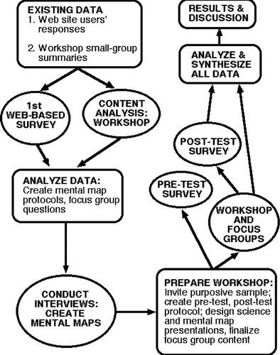
The case study drew on several kinds of data collection, including Web surveys, mental mapping (also known as schematic mind maps, cognitive maps, system diagrams, or system influence diagrams; CitationNorthcutt and McCoy 2004), focus groups, content analysis (i.e., transcribing the recordings of scientist–nonscientist discussions at workshops and then coding or categorizing of bodies of text into themes or clusters of meanings to understand patterns, relationships, sequences, or differences; CitationRobson 2002). The combination of methods () allowed for the consideration of multiple perspectives on the use and potentials of GIS technology in analyzing environmental questions among a variety of involved people (see CLAMS 2007 for a full range of GIS products). Participants in the study were clearly divided between scientists and nonscientists, and we acknowledged the cultural and institutional divides between these groups to analyze our findings. Detailed explanation of methodology of the CLAMS case study can be found in CitationDuncan (2006) and Duncan and Lach (2006a, 2006b). This article presents updated interpretations of the findings given the previous discussion of communication and empowerment issues by GIS technology, social constructivist perspectives and public participation for environmental problem framing, and the contemporary scientist's quest for truth. Here we summarize the major steps in the case study methodology chronicled and justified in much more detail by those earlier papers:
-
Initial Web surveys were developed with a protocol pilot-tested among a sample of scientists and nonscientists and adjustments made to clarify certain questions before deployment. Ultimately, the questions were clustered as to the familiarity with CLAMS, the purpose of downloading maps and databases, map usability, uncertainty and levels of trust, assumptions, understanding of findings, and demographics.
-
In the summer of 2002, CLAMS scientists hosted a workshop designed to elicit information from stakeholders and the interested, attentive public, about their reactions to CLAMS research, its tools, and its maps. Approximately 100 people were invited, including representatives from the forest industry, nonindustrial forest owners, NGOs, watershed councils, business groups, state and federal agencies, tribal groups, county offices, academic researchers, and interested members of the public. Most were at least somewhat familiar with CLAMS. Participants broke into smaller groups to address four questions:
-
What values do you see in coarse, regional-scale assessments in general (i.e., small scale, cartographically)?
-
What specific benefits do you see in CLAMS?
-
What concerns do you have about CLAMS?
-
What changes or improvements in CLAMS research and models would you suggest?
-
-
Mental maps were then used to interpret, discover, and synthesize meaning from the small group discussions, following a defined protocol, and in this case based on data (text) obtained by interviewing workshop attendees and transcribing their responses (again, see CitationDuncan and Lach 2006a, Citation2006b, for more details and for some of the maps).
-
Focus group discussions at a follow-up workshop included prior attendees in the categories of CLAMS science team members, representatives from one forest industry corporation, one nonindustrial forest owner, two watershed councils, two NGOs, two federal agencies, one state agency, and a tribal confederation. Discussion questions included the following:
-
What is a GIS map?
-
What are the elements of trust between mapmakers and map users in GIS?
-
What new ideas and powers does GIS bring to the table?
-
What unintended consequences emerge from GIS technology?
-
How do we go from the abstract to the concrete in using GIS maps?
-
How are GIS maps useful in mutual learning and conflict resolution?
-
-
Several hypotheses were developed for the follow-up workshop to assist in the design of the protocol of a pretest–posttest survey.
-
Technically trained scientists are more likely than nonscientists to recognize the potential analytical power of GIS databases.
-
Nonscientists are more likely than scientists to accept “map tyranny” (the power of a map to appear as “truth” to most observers).
-
Nonscientists (especially as map users) are more likely than scientists (especially as mapmakers) to comprehend the power of access to data and technology or to feel pushed aside from the map production process.
-
The idea of mutual learning will be more familiar and appealing to nonscientists than scientists.
-
A guided and thoughtful dialogue is more likely to generate ideas and change minds than a single presentation.
-
Figure 1 Research design for the CLAMS case study, after CitationDuncan and Lach (2006a). Process starts at the upper left and moves counterclockwise.
The utility of this database lay particularly in assessing the value of an intervention at the workshop, such as focusing attention on technology, learning, and communication issues around the use of GIS in the CLAMS project. The opportunity to compare scientist and nonscientist responses was effectively precluded in the control group by the extremely low number of scientists—just two in the pretest and only one in the posttest.
The first two sources examined (Web site survey and 2002 workshop) were essentially opportunistic, in the sense that the analysis took advantage of their preexistence, and undertook to learn something from unexamined raw data. The remaining three (mental maps, 2004 follow-up workshop and focus groups, and pretest–posttest survey with control) were designed, with input from the “opportunistic” two, specifically for this study.
Central to our understanding of the CLAMS study is the fact that most participants in the final research workshop, where focus groups were conducted, had been around the CLAMS project for more than five years by that time. All scientists involved had been a part of the modeling study from the beginning. Many nonscientists had attended a workshop and small-group study several years after the project began and then participated in the culminating research workshop nearly three years later. As a result, some of them were becoming readily familiar with the scientists as well as the GIS technology and its mapped outputs, making them quite sophisticated and attentive participants and questioners of the knowledge base. These elements of elapsed time and relationship building were key to our findings.
Major Findings of the CLAMS Case Study
One of the clearest findings from the CLAMS study is that GIS technology is not going to improve communications unaided, but the process it initiates, of communicating over a multilayered map, even in a conflict-ridden setting, can become itself a tool of change. GIS mapped outputs (CLAMS 2007), by changing the nature of the information, improve its utility; for example, one participant noted the qualitative difference between looking at tables of numbers and geographic subunits to understand population dynamics. This appears to be true even if the data are accessed passively, as when landowners review the data layers produced in scientists' labs. The process of grappling with new views of their world helps participants think about information even as they question and absorb it: whose assumptions are valid, whose questions most influence the ensuing stories. Current theory on information exchange supports the idea that sharing and communicating the new information unveiled by GIS maps will lead to actual learning (CitationHendriks 2000). The CLAMS case suggests that the existing power structures may be altered by the growing confidence of nonscientist map users bringing alternative perspectives to the table (e.g., CitationElwood and Leitner 2003; CitationBouwen and Taillieu 2004). The process could then cascade through multiple facets of NRM, from language used to organizational structure of any given investigation. This offers a contrasting outcome to some developing country settings, in which the introduction of new technology can shut down the propensity for collaboration (e.g., CitationDunn et al. 1999; CitationTurner 2003; CitationWeiner and Harris 2003; CitationKyem 2004). Further research could clarify whether this is due to a difference in existing power structures or the important effects of elapsed time.
In tune with a changing social context for collaboration across GIS maps, scientists in the CLAMS study defined a “new ethics of presentation” that disperses responsibility for creating new knowledge, another reflection of the changing role of science already noted (e.g., CitationPriest 1995; CitationWeber and Word 2001; CitationLach et al. 2003). It also begins to generate a newly recognized mutual responsibility: Both scientists and nonscientists saw this, as these comments by an NGO representative and a GIS specialist, respectively, suggest:
I think that because anybody who's going to think critically about this information is going to have to go back to the tables and look at well how did you come up with that, what is that data, how does that model work, what is that stream reach data, what is that vegetation layer?
I think the tools really ask people to be savvy, you know just like everything else around us in a culture of information, there's so much information out there you can fire off ten maps. I think what it comes down to is people have to say well I'm looking at an image and making a contribution. The maps have to start requiring people to ask the question of where it's coming from, is it really saying (this) and who made it?
The implication is that taking time to think about where our worldview comes from before we embark on discussing landscape change (e.g., CitationBenda et al. 2002) is becoming imperative. A watershed council coordinator noted:
The very act of putting the issue into a spatially explicit framework really reframes the issue and changes the debate. When someone's talking about too much clear cutting or too short a rotation or not enough salmon or whatever, and you can look at that on a map and say OK now here's where your experience is and here's what's going on down here or here's what going on over there, it will really reframe the debate in ways that are generally positive.
The concept of privileged knowledge emerged clearly through several qualitative research methods (CitationDuncan 2006; CitationDuncan and Lach 2006a). As discussed earlier, power relationships within organizations are known to affect methods and styles of communication. Therefore, a privileged knowledge property emerges where we can see the influence of only a single group—in this case the scientist mapmakers—on how data are used or displayed. Thus, to take several examples from the feeder elements, we see quality control, assumptions, interpretation, and credibility, all essentially under the control of scientists, serving to support the status quo. In the CLAMS case it emerged from a group of influences including institutional privilege, access to funding and technology, and professional training, each of which all participants acknowledged, both explicitly and implicitly.
It is clear from the findings that, without fanfare, science in this case has an altered status, from arbiter of truth for a privileged group, producing privileged knowledge, to tool of inquiry with broad potential social applications. Once attentive parties explore meanings, there is less likelihood of adversarial declarations of bias, and a greater chance that communities of interested people will change their focus from conflict to interaction, from content to idea. Such a seedbed nurtures suggestions for collaboration, for directed uses of technology, and for improved understanding on multiple levels and subjects—postnormal science in action (CitationFuntowicz and Ravetz 2001). With the development of new, informal knowledge communities, the idea that scientists can learn from nonscientists has room to grow.
The issue of access is clearly a focal point for the power imbalance between the mapmaker-scientists and map user-nonscientists. This differential is not uncommon in settings involving scientists, nonscientists, and the engagement of new technology (e.g., CitationPriest 1995; CitationPouyat 1999; CitationNyerges, Jankowski, and Drew 2002); in developing economies it is more likely to manifest as the division between foreign aid providers or researchers and local inhabitants (e.g., CitationHarris and Weiner 2003; CitationTurner 2003). This pattern of influence may also reflect the tendency of new technologies, in the early diffusion stage, to carry certain groups along more quickly than others (CitationRohracher 2003). The result here is that nonscientists have universally been excluded from technology development and typically remain outside the next diffusion stage of adoption or implementation. The literature suggests that uneven development across user groups is typical of technology uptake (e.g., CitationBeard 2002; CitationRohracher 2003).
It was apparent from interviews that although the social power differential was actual, scientists did not consciously seek it. Nonetheless, it meant that nonscientists did not have input into the question-framing process, a power issue that has been noted elsewhere (e.g., CitationRappert 2001). A nonscientist summed up the effects of this imbalance:
It's not a functional relationship unless we have access. In contrast, how are we supposed to do the business of watershed restoration without it? It will sever us at some point if we can't stay up with the technology.
By contrast, the explicit preference of scientists for managing the technical side of the project reflected their desire to control its research component. Naturally this has implications for the power of knowledge creation: It shaped the questions they asked; the queries they posed to their databases; and also their acceptance of uncertainty, fuzziness, and assumptions as part of the research process; and it tended at first to exclude other participants.
The apparent “insider” power that results, however, could be eroded, or even neutralized, by lack of trust felt by map user-nonscientists, reflecting what CitationPahl-Wostl (2002) has called lock-in effects preventing innovation and change. Interviews and subsequent focus group discussions suggest that in the CLAMS case this distrust phase definitely occurred, but a critical mass of participants had been willing to “suspend disbelief” and move forward in negotiations of meaning (sensu CitationWeber and Word 2001) toward a larger end of better understanding the landscape together.
This gradual development through time presaged the other key pattern emerging in case study analysis: the potential for social change. Different conceptions by different participants of how social change might take place reflected their several ideas of crucial balance points, in the sense of intentional changes that could substantially affect future power relations (CitationLatour 1993; CitationRotmans, Kemp, and van Asselt 2001). Scientists acknowledged the legitimacy of nonscientists' concerns and questions about maps and databases after they were constructed and saw the possibility of future collaboration, whereas nonscientists centered their ideas of change on the building of trust; they did not see a valuable future in using GIS to help frame decision problems without mutual trust. A land manager noted that considerable change had already transpired in that the spread of spatial awareness had measurably improved both internal and external communications within his land management agency.
Story making represents power, derived from the framing of questions and the interpretation of findings. Through the period of this study, clear movement along the trajectory of social change emerged in a detectable shift from unilateral to collaborative story making about landscapes. Findings from the CLAMS study illustrate and support several larger themes: (1) scientists have long been in control of the problem framing, data gathering and analysis, and interpretation of results; (2) nonscientists are increasingly seeking collaboration to take advantage of this and other new technologies in determining their futures and those of their landscapes; and (3) based on a growing body of experience with public participation, managers of public lands may be recognizing more fully the political need to share story-making power (CitationDuncan and Lach 2006b).
State, federal, and private stakeholders frequently request CLAMS maps and databases as the best data and display mechanisms available for their purposes (T. A. Spies, personal communication, 13 August 2007). Even though the technology remains largely in the hands of mapmaking scientists, the continuing interactions with outside parties have inevitably changed the nature of the inquiries into the data. In this particular setting, then, there appears to be a choice for public participants about whether they want to follow through on initial gains in “trust and faith” with the mapmakers, and become more active narrators in the story of their landscapes.
Let us amplify here what is meant by trust and faith. Following from the unintended consequences, as well as the intended ones of grappling more efficiently with huge amounts of spatial data, a new phase, or subphase, might be added to the currently accepted lists of phasing in technology diffusion. Somewhere between trial and adoption (CitationBrunn, Dahlman, and Taylor 1998), or between implementation and confirmation (CitationRogers 2003), might come a process called the development of faith.
Simply put, it is an optimistic, forward-looking view of the possibility of change, coming into play once it is shared by a critical mass of actors, to make a difference in how technology-assisted problem solving is approached. It evolves from the building of trust through time and requires mutual respect for alternate ways of learning and creating knowledge. It should be noted that this phase can follow a number of trajectories, one of which is failure to establish trust. In the CLAMS case, the more optimistic path was followed, but it did take a number of years, and all players did not necessarily accept it. Specifically, this phase will need to emerge from the willingness of collaborators to share in the problem-framing period of an environmental assessment, and it might represent a development in which the social and technical understandings of technology begin to coalesce to some extent. The result is that dialogue about the technology itself, and about subjects for which it is used in the discovery process, improves in breadth and depth. If the development of faith is combined with the preexistence or simultaneous emergence of balance points, the use of the technology is more likely to stick, and even to spread in creative ways.
In this case, it is conceivable that the CLAMS project, and possibly others like it, is at a critical balance point chiefly involving trust and learning, and the ongoing commitment of individuals and institutions. In theory, primary actors representing both scientists and nonscientists could collaborate to shift that balance intentionally to a permanently improved condition of public interaction in NRM. The final phase—adoption or confirmation—is then more likely to be achieved.
Conclusion
To conclude, we return to the three research questions posed at the outset, answering each in turn:
-
How can GIS maps contribute to mutual learning in the NRM arena? With clear intentions and the right support, GIS maps might become a productive medium for mutual learning, for combining and reconsidering multiple ways of knowing about landscapes and ecosystems. Further, they might move into the realm of designing and structuring decision problems; to date their utility is largely founded on visualizing evaluation results, typically a science-driven exercise (CitationCasner 1991; CitationJankowski, Andrienko, and Andrienko 2001). In NRM, the introduction of GIS does indeed require a revision of the way we think about, learn from, and use maps, specifically when resource management engages nonscientists. In this context, it is clear that GIS technology is not going to improve mutual learning without being aided by the important process of clear communication that cuts through the prejudices and power plays that could hamper NRM. The very process initiated by GIS, that of communicating over a multilayered map, even in a conflict-ridden setting, can itself become a tool of change. The case study further shows support for existing notions of how sharing and communicating the new information unveiled by GIS maps will in fact lead to actual learning.
-
Can GIS technology and its diffusion play a transformative role in NRM? As discussed earlier, there is staging within phases of technology diffusion deriving from a variety of sources, ranging from fear of change and new technology, to lack of resources and training, scarcity of infrastructure, and sociocultural barriers (CitationBrunn, Dahlman, and Taylor 1998), where questions of societal values and of dependence and dominance need consideration (CitationMasser 1996). Following from what the CLAMS case study suggests about unintended consequences of contextual change and power relations, as well as the intended ones of grappling more efficiently with huge amounts of spatial data, a new phase, or subphase, might be added to the currently accepted lists of phasing in technology diffusion. Somewhere between trial and adoption (CitationBrunn, Dahlman, and Taylor 1998), or between implementation and confirmation (CitationRogers 2003), might come the process that we have discussed as the development of faith.
-
How are the properties of public interaction—power imbalances, trust, even forces for social change—affected when GIS technology is engaged? A primary goal for the scientist and layman, or the scientist and the resource manager, is to use the capacity of the technology to help achieve a critical balance point involving trust and learning, and the ongoing commitment of individuals and institutions. In theory, primary actors representing both scientists and nonscientists could collaborate to shift that balance intentionally to a permanently improved condition of data and analysis transparency in public interaction in NRM. The final phase—adoption or confirmation of the technology and the improved process—is then more likely to be achieved.
Theory and practice cannot always be so easily manipulated, of course, but it is clear from our findings that GIS maps provide a potential portal to the collaborative development of stories about landscapes. When an impersonal database can be queried and the results seen by stakeholders of many stripes, often literally standing around a map together, something important happens to an adversarial dynamic. The more space there is to build stories together or tell individual stories to each other, the more space there is for the kind of mutual learning that keeps minds open to new possibilities. Closer understanding of place, via stories, contributes in turn to the development of faith in the social and technical value of the technology.
GIS fundamentally changes how information is viewed, literally, by many different groups, for its maps and databases contain varying levels of uncertainty, multiple embedded assumptions, potentially privileged knowledge, and considerable power as story-makers, along with unintended and unexplored social consequences. GIS maps and databases are used here as the central refractor of ideas about relationships between scientists and lay audiences; between the postmodern understanding of privilege and social change; and ultimately between technology and meaning, where changing expectations about the role of science in NRM resonate most profoundly.
Our findings further suggest that use of GIS through time may change the realm of designing and structuring decision problems, adjusting it from a largely science-driven exercise in NRM to a more collaborative story-making one. Recognizing that science is first and foremost a storytelling enterprise helps us see that unilateral story-making by mapmakers has significant ramifications for public involvement, trust, confidence, and decision-making. Story-making requires trust in the elements of the story, both by teller and listener, and surely also requires mutual trust between storyteller and listener. Although epistemological differences between scientists and lay audiences remain, they can be offset through such collaboration, with concomitant shifts in power structures that could affect a range of conditions, including rates of technology diffusion and management of a broad transition in how natural resources are perceived and utilized. A strong contributor to story-making is the gradual transition in understanding of GIS technology, from a technical understanding of its production capabilities, to a social understanding of its communication capabilities. In the case of the CLAMS project (and likely for similar endeavors), this has profound implications for how GIS maps might be coopted for story-making by interested parties other than the scientists who are to date the only mapmakers.
Acknowledgement
The support of Tom Spies and Norm Johnson, coprincipal investigators of the Coastal Landscape Analysis and Modeling Study at Oregon State University, is gratefully acknowledged. The very careful, thorough reviews of five anonymous referees and the insightful comments of Annals Methods, Models and GIS section editor Mei-Po Kwan significantly improved the article.
Related Research Data
References
- Aetrs , J. C. J. H. , Clarke , K. C. and Keuper , A. D. 2003 . Testing popular visualization techniques for representing model uncertainty . Cartography and Geographic Information Science , 30 ( 3 ) : 249 – 61 .
- Aitken , S. 2002 . “ Public participation, technological discourses and the scale of GIS ” . In Community participation and geographic information systems , Edited by: Craig , W. J. , Harris , T. M. and Weiner , D. 357 – 66 . London and New York : Taylor & Francis .
- Batty , M. 2007 . Planning support systems: Progress, predictions, and speculations on the shape of things to come http://www.casa.ucl.ac.uk/publications/workingPaperDetail.asp?ID=122 University College London Centre for Advanced Spatial Analysis (CASA) Working Paper 122 (last accessed 30 April 2008)
- Beard , J. W. 2002 . Management of technology: A three-dimensional framework with propositions for future research . Knowledge, Technology, and Policy , 15 ( 3 ) : 45 – 57 .
- Benda , L. , Poff , N. L. , Tague , C. , Palmer , M. A. , Pizzuto , J. , Cooper , S. , Stanley , E. and Moglen , G. 2002 . How to avoid train wrecks when using science in environmental problem solving . BioScience , 52 ( 12 ) : 1127 – 37 .
- Berkes , F. , Colding , J. and Folke , C. 2000 . Rediscovery of traditional ecological knowledge as adaptive management . Ecological Applications , 10 ( 5 ) : 1251 – 62 .
- Blahna , D. J. and Yonts-Shepard , S. 1989 . Public involvement in resource planning: Toward bridging the gap between policy and implementation . Society and Natural Resources , 2 : 209 – 27 .
- Bojorquez-Tapia , L. A. , Diaz-Mondragon , S. and Ezcurra , E. 2001 . GIS-based approach for participatory decision-making and land suitability assessment . International Journal of Geographical Information Science , 15 ( 2 ) : 129 – 51 .
- Bouwen , B. and Taillieu , T. 2004 . Multi-party collaboration as social learning for interdependence: Developing relational knowing for sustainable natural resource management . Journal of Community & Applied Social Psychology , 14 ( 3 ) : 137 – 53 .
- Brunn , S. D. , Dahlman , C. T. and Taylor , J. S. 1998 . GIS uses and constraints on diffusion in Eastern Europe and the former USSR . Post-Soviet Geography and Economics , 39 ( 10 ) : 566 – 87 .
- Carpenter , S. R. 2002 . Ecological futures: Building an ecology of the long now . Ecology , 83 ( 8 ) : 2069 – 83 .
- Carver , S. , Evans , A. , Kingston , R. and Turton , I. 2000 . Accessing geographical information systems over the World Wide Web: Improving public participation in environmental decision-making . Information, Infrastructure and Policy , 6 : 157 – 70 .
- Carver , S. , Watson , A. , Waters , T. , Matt , R. , Gundereson , K. and Davis , B. 2009 . “ Developing computer-based participatory approaches to mapping landscape values for landscape and resource management ” . In Planning support systems: Best practices and new methods , Edited by: Geertman , S. and Stillwell , J. 395 – 420 . Berlin : Springer-Verlag .
- Casner , S. M. 1991 . A task-analytic approach to the automated design of graphic presentations . ACM Transactions on Graphics , 10 : 111 – 51 .
- Coastal Landscape Analysis Modeling Study (CLAMS) . 2007 . Coastal Landscape Analysis Modeling Study http://www.fsl.orst.edu/clams (last accessed 30 April 2008)
- Committee on the Geographic Foundation for Agenda 21, National Research Council . 2002 . Down to earth: Geographical information for sustainable development in Africa , Washington, DC : National Academies Press .
- Cooperrider , A. Y. 1996 . Science as a model for ecosystem management: Panacea or problem? . Ecological Applications , 6 ( 3 ) : 736 – 37 .
- Cosio , R. G. G. 1998 . Social constructivism and capacity building for environmental governance . International Planning Studies , 3 ( 3 ) : 367 – 89 .
- Duncan , S. L. 2006 . Mapping whose reality? Geographic information systems and “wild science.” . Public Understanding of Science , 15 : 411 – 34 .
- Duncan , S. L. and Lach , D. H. 2006a . GIS technology in natural resource management: Process as a tool of change . Cartographica , 41 ( 3 ) : 201 – 15 .
- Duncan , S. L. and Lach , D. H. 2006b . Privileged knowledge and social change: Effects on different participants of using geographic information systems technology in natural resource management . Environmental Management , 38 ( 2 ) : 267 – 85 .
- Duncan , S. L. and Thompson , J. 2006 . Forest plans and ad hoc scientist groups in the 1990s: Coping with the forest service viability clause . Forest Policy and Economics , 9 : 32 – 41 .
- Dunn , C. E. , Atkins , P. J. , Blakemore , M. J. and Townsend , J. G. 1999 . Teaching geographical information handling skills for lower-income countries . Transactions in GIS , 3 ( 4 ) : 319 – 33 .
- Elwood , S. 2006a . Beyond cooptation or resistance: Urban spatial politics, community organizations, and GIS-based spatial narratives . Annals of the Association of American Geographers , 96 ( 2 ) : 323 – 41 .
- Elwood , S. 2006b . Critical issues in participatory GIS: Deconstructions, reconstructions, and new research directions . Transactions in GIS , 10 ( 5 ) : 693 – 708 .
- Elwood , S. 2008 . Grassroots groups as stakeholders in spatial data infrastructures: Challenges and opportunities for local data development and sharing . International Journal of Geographic Information Science , 22 : 71 – 90 .
- Elwood , S. and Ghose , R. 2004 . PPGIS in community development planning: Framing the organizational context . Cartographica , 38 ( 3–4 ) : 19 – 33 .
- Elwood , S. and Leitner , H. 2003 . GIS and spatial knowledge production for neighborhood revitalization: Negotiating state priorities and neighborhood visions . Journal of Urban Affairs , 25 ( 2 ) : 139 – 57 .
- Fall , A. , Daust , D. and Morgan , D. G. 2001 . A framework and software tool to support collaborative landscape analysis: Fitting square pegs into square holes . Transactions in GIS , 5 ( 1 ) : 67 – 86 .
- Fischer , F. 2000 . Citizens, experts, and the environment: The politics of local knowledge , Durham, NC : Duke University Press .
- Fischer , G. and Ostwald , J. 2001 . Knowledge management: Problems, promises, realities, and challenges . IEEE Intelligent Systems , 16 ( 1 ) : 60 – 72 .
- Foucault , M. 1980 . Power/knowledge: Selected interviews and other writings , New York : Pantheon .
- Fox , J. , Rindfuss , R. R. , Walsh , S. J. and Mishra , V. 2003 . People and the environment: Approaches for linking household and community surveys to remote sensing and GIS , Berlin : Kluwer Academic .
- Freire , P. 1998 . Pedagogy of the heart , Edited by: Donaldo Macedo , A. O. New York : Continuum .
- Funtowicz , S. and Ravetz , J. 2001 . “ Post-normal science: Science and governance under conditions of complexity ” . In Interdisciplinarity in technology assessment: Implementation and its chances and limits , Edited by: Decker , M. 15 – 24 . Berlin : Springer .
- Gethman , C. F. 2001 . “ Participatory technology assessment: Some critical questions ” . In Interdisciplinarity in technology assessment: Implementation and its chances and limits , Edited by: Decker , M. 3 – 13 . Berlin : Springer .
- Ghose , R. 2001 . Use of information technology for community empowerment: Transforming geographical information systems into community information systems . Transactions in GIS , 5 : 141 – 63 .
- Ghose , R. and Elwood , S. 2003 . Public participation GIS and local political context: Propositions and research directions . URISA Journal , 15 : 17 – 24 . (APA II)
- Gillespie , S. R. 2000 . An empirical approach to estimating GIS benefits . URISA Journal , 12 ( 1 ) : 7 – 13 .
- Gunderson , K. and Watson , A. 2007 . Understanding place meanings on the Bitterroot National Forest, Montana . Society and Natural Resources , 20 : 705 – 21 .
- Harris , T. and Weiner , D. 1998 . Empowerment, marginalization, and “community-integrated” GIS . Cartography and Geographic Information Systems , 25 ( 2 ) : 67 – 76 .
- Harris , T. and Weiner , D. 2003 . Linking community participation to geospatial technologies . Arid Lands Newsletter , 53 http://ag.arizona.edu/OALS/ALN/aln53/aln53toc.html (May/June) (last accessed 30 April 2008)
- Hendriks , P. H. 2000 . An organizational learning perspective on GIS . International Journal of Geographical Information Science , 14 ( 4 ) : 373 – 96 .
- Hillier , J. 2003 . Fighting over the forests: Environmental conflict and decision-making capacity in forest planning processes . Australian Geographical Studies , 41 ( 3 ) : 251 – 69 .
- Jankowski , P. , Andrienko , N. and Andrienko , G. 2001 . Map-centered exploratory approach to multiple criteria spatial decision-making . International Journal of Geographical Information Science , 15 ( 2 ) : 101 – 27 .
- Jankowski , P. and Nyerges , T. 2001 . GIS-supported collaborative decision-making: Results of an experiment . Annals of the Association of American Geographers , 91 ( 1 ) : 48 – 70 .
- Kiel , D. E. and Rines , G. K. . Scale effects on automated production of cadastral and transportation maps . Paper presented at the ASPRS-ACSM annual convention . Albuquerque, NM.
- Kingston , R. P. , Carver , S. J. , Evans , A. J. and Turton , I. J. 2000 . Web-based public participation geographical information systems: An aid to local environmental decision-making . Computers, Environment and Urban Systems , 24 : 109 – 25 .
- Klinkenberg , B. 2007 . Geospatial technologies and the geographies of hope and fear . Annals of the Association of American Geographers , 97 ( 2 ) : 350 – 60 .
- Kwan , M.-P. 2002 . Feminist visualization: Re-envisioning GIS as a method in feminist geographic research . Annals of the Association of American Geographers , 92 ( 4 ) : 645 – 61 .
- Kyem , P. A. K. 2004 . Power, participation, and inflexible institutions: An examination of the challenges to community empowerment in participatory GIS applications . Cartographica , 38 ( 3–4 ) : 5 – 17 .
- Lach , D. , List , P. , Steel , B. and Shindler , B. 2003 . Advocacy and credibility of ecological scientists in resource decisionmaking: A regional study . BioScience , 53 ( 2 ) : 170 – 79 .
- Latour , B. 1987 . Science in action: How to follow scientists and engineers through society , Cambridge, MA : Harvard University Press .
- Latour , B. 1993 . We have never been modern , Cambridge, MA : Harvard University Press .
- Lawrence , R. L. , Daniels , S. E. and Stankey , G. H. 1997 . Procedural justice and public involvement in natural resource decision-making . Society and Natural Resources , 10 : 577 – 89 .
- Laws , D. , Scholz , R. W. , Shiroyama , H. , Susskind , L. , Suzuki , T. and Weber , O. 2004 . Expert views on sustainability and technology implementation . International Journal of Sustainable Development and World Ecology , 11 : 247 – 61 .
- Lee , K. 1993 . Compass and gyroscope: Integrating science and politics for the environment , Washington, DC : Island Press .
- Macnab , P. 2002 . “ There must be a catch: Participatory GIS in a Newfoundland fishing community ” . In Community participation and geographic information systems , Edited by: Craig , W. , Harris , T. M. and Weiner , D. 192 – 204 . London and New York : Taylor & Francis .
- Mark , D. M. 2000 . Geographic information science: Critical issues in an emerging cross-disciplinary research domain . URISA Journal , 12 ( 1 ) : 45 – 54 .
- Masser , I. 1996 . GIS diffusion: The adoption and use of geographical information systems in local government in Europe , London and New York : Taylor & Francis .
- McKendry , J. E. 2000 . The influence of map design on resource management decision-making . Cartographica , 37 ( 2 ) : 13 – 24 .
- Mennis , J. L. , Peuquet , D. J. and Qian , L. 2000 . A conceptual framework for incorporating cognitive principles into geographical database representation . International Journal of Geographical Information Science , 14 ( 6 ) : 501 – 20 .
- Monmonier , M. 1996 . How to lie with maps, , 2nd ed. , Chicago : University of Chicago Press .
- Morain , S. , ed. 1999 . GIS solutions in natural resource management: Balancing the technical-political equation , Santa Fe, NM : Onwood Press .
- Narayanan , V. K. 2001 . Managing technology and innovation for competitive advantage , Upper Saddle River, NJ : Prentice-Hall .
- National Environmental Policy Act (NEPA) . 2007 . http://www.epa.gov/compliance/nepa (last accessed 30 April 2008)
- Norheim , R. 2004 . How institutional cultures affect results: Comparing two old-growth forest mapping projects . Cartographica , 38 ( 3–4 ) : 35 – 52 .
- Northcutt , N. and McCoy , D. 2004 . Interactive qualitative analysis: A systems method for qualitative research , Thousand Oaks, CA : Sage .
- Nyerges , T. , Jankowski , P. and Drew , C. 2002 . Data-gathering strategies for social-behavioral research about participatory geographical information system use . International Journal of Geographical Information Science , 16 ( 1 ) : 1 – 22 .
- Nyerges , T. , Jankowski , P. , Tuthill , D. and Ramsey , K. 2006 . Collaborative water resource decision support: Results of a field experiment . Annals of the Association of American Geographers , 96 ( 4 ) : 699 – 725 .
- Nyhus , P. J. , Westley , F. R. , Lacy , R. C. and Miller , P. S. 2002 . A role for natural resource social science in biodiversity risk assessment . Society and Natural Resources , 15 : 923 – 32 .
- Obermeyer , N. 1998 . The evolution of public participation GIS . Cartography and Geographic Information Systems , 25 ( 2 ) : 65 – 66 .
- O'Sullivan , D. 2006 . Geographical information science: Critical GIS . Progress in Human Geography , 30 ( 6 ) : 783 – 91 .
- Pahl-Wostl , C. 2002 . Towards sustainability in the water sector—The importance of human actors and processes of social learning . Aquatic Sciences , 64 : 394 – 411 .
- Pickles , J. 1995 . “ Representations in an electronic age: Geography, GIS, and democracy ” . In Ground truth: The social implications of geographic information systems , Edited by: Pickles , J. 1 – 30 . New York : Guilford .
- Pickles , J. 2004 . A history of spaces: Cartographic reason, mapping and the geo-coded world , London and New York : Routledge .
- Polanyi , J. 2000 . Science, scientists, and society . Queen's Quarterly , 107 : 31 – 36 .
- Pouyat , R. V. 1999 . Science and environmental policy—Making them compatible . BioScience , 49 ( 4 ) : 281 – 86 .
- Priest , S. H. 1995 . Information equity, public understanding of science, and the biotechnology debate . Journal of Communication , 45 ( 1 ) : 39 – 54 .
- Ramasubramanian , L. 2009 . Geographic information science and public participation , Berlin : Springer .
- Rappert , B. 2001 . The distribution and resolution of the ambiguities of technology, or why Bobby can't spray . Social Studies of Science , 31 ( 4 ) : 557 – 91 .
- Robinson , A. H. and Petchenik , B. B. 1976 . The nature of maps , Chicago : University of Chicago Press .
- Robson , C. 2002 . Real world research: A resource for social scientists and practitioner-researchers, , 2nd ed. , Oxford, UK : Blackwell Publishing .
- Rogers , E. M. 2003 . Diffusion of innovations, , 5th ed. , New York : Free Press .
- Rohracher , H. 2003 . The role of users in the social shaping of environmental technologies . Innovation , 16 ( 2 ) : 177 – 92 .
- Rotmans , J. , Kemp , R. and van Asselt , M. 2001 . “ Transition management: A promising policy perspective ” . In Interdisciplinarity in technology assessment: Implementation and its chances and limits , Edited by: Decker , M. 165 – 97 . Berlin : Springer .
- Sandercock , L. 2004 . Towards a planning imagination for the 21st century . Journal of the American Planning Association , 70 ( 2 ) : 133 – 41 .
- Sarewitz , D. 2004 . How science makes environmental controversies worse . Environmental Science & Policy , 7 : 385 – 403 .
- Schuurman , N. 1999 . Critical GIS: Theorizing an emerging science . Cartographica , 36 ( 4 ) : 1 – 101 .
- Schuurman , N. 2006 . Formalization matters: Critical GIS and ontology research . Annals of the Association of American Geographers , 96 ( 4 ) : 726 – 39 .
- Schweizer , T. 1998 . “ Epistemology: The nature and validation of anthropological knowledge ” . In Handbook of methods in cultural anthropology , Edited by: Robson , C. 39 – 87 . Walnut Creek, CA : AltaMira Press .
- Sieber , R. E. 2000a . Conforming (to) the opposition: The social construction of geographical information systems in social movements . International Journal of Geographical Information Science , 14 ( 8 ) : 775 – 93 .
- Sieber , R. E. 2000b . GIS implementation in the grassroots . URISA Journal , 12 ( 1 ) : 15 – 29 .
- Sieber , R. E. 2004 . A PPGIScience? . Cartographica , 38 ( 3–4 ) : 1 – 4 .
- Sieber , R. E. 2006 . Public participation geographic information systems: A literature review and framework . Annals of the Association of American Geographers , 96 ( 3 ) : 491 – 507 .
- Spies , T. A. , Johnson , K. N. , Burnett , K. M. , Ohmann , J. L. , McComb , B. C. , Reeves , G. H. , Bettinger , P. , Kline , J. D. and Garber-Yonts , B. 2007 . Cumulative ecological and socioeconomic effects of forest policies in coastal Oregon . Ecological Applications , 17 ( 1 ) : 5 – 17 .
- Taylor , P. J. and Johnston , R. J. 1995 . “ Geographic information systems and geography ” . In Ground truth: The social implications of geographic information systems , Edited by: Pickles , J. 51 – 67 . New York : Guilford .
- Toulmin , S. 1990 . Cosmopolis: The hidden agenda of modernity , Chicago : University of Chicago Press .
- Tufte , E. R. 1983 . The visual display of quantitative information , Cheshire, CT : Graphics Press .
- Turner , M. D. 2003 . Methodological reflections on the use of remote sensing and geographic information science in human ecological research . Human Ecology , 31 ( 2 ) : 255 – 79 .
- Walker , D. H. , Leitch , A. M. , De Lai , R. , Cottrell , A. , Johnson , A. K. L. and Pullar , D. 2002 . “ A community-based and collaborate GIS joint venture in rural Australia ” . In Community participation and geographic information systems , Edited by: Craig , W. , Harris , T. M. and Weiner , D. 137 – 52 . London and New York : Taylor & Francis .
- Weber , J. R. and Word , C. S. 2001 . The communication process as evaluative context: What do non-scientists hear when scientists speak? . BioScience , 51 ( 6 ) : 487 – 95 .
- Weibel , R. and Buttenfield , B. P. 1992 . Improvement of GIS graphics for analysis and decision-making . International Journal of Geographical Information Science , 6 ( 3 ) : 223 – 45 .
- Weiner , D. and Harris , T. 2003 . Community-integrated GIS for land reform in South Africa . URISA Journal , 15 ( 2 ) : 61 – 73 . http://urisa.org/Journal/protect/APANo2/Weiner.pdf (last accessed 30 April 2008)
- Wejnert , B. 2002 . Integrating models of diffusion of innovations: A conceptual framework . Annual Review of Sociology , 28 : 297 – 326 .
- Wright , D. J. , Goodchild , M. F. and Proctor , J. D. 1997a . Demystifying the persistent ambiguity of GIS as “tool” versus “science.” . Annals of the Association of American Geographers , 87 ( 2 ) : 346 – 62 .
- Wright , D. J. , Goodchild , M. F. and Proctor , J. D. 1997b . Still hoping to turn that theoretical corner . Annals of the Association of American Geographers , 87 ( 2 ) : 373