Abstract
Theorists within and beyond the discipline of geography increasingly realize that boundaries are not simply lines that enclose and define territories. Boundaries also regulate and are reproduced by acts of movement. Movement, beyond and across, as well as within a bounded territory, serves to reproduce the territory that is being bounded. It follows that to understand the history of a territorial entity one must go beyond tracing the spatially fixed activities that occur within that territory or the discursive strategies through which the territory is made to appear natural. One must also trace the acts of movement that occur within, across, and outside the territory's boundaries and the designation of specific spaces of movement as beyond territorial control. In short, one cannot understand the construction of “inside” space as a series of territories of fixity, society, modernization, and development without simultaneously understanding the construction of “outside” space as an arena of mobility that is deemed unsuitable for territorial control. In this article, this perspective is applied to the preeminent normative territory of modernity—the sovereign state—and attention is directed specifically to the designation of the world-ocean as a space of mobility outside the boundaries of the state-society units that purportedly constitute the modern world. Through an analysis of representations of marine space on 591 world maps printed in Europe and the Americas between 1501 and 1800, this article traces the construction of the ocean as an external space of mobility, antithetical to the norm of the territorial state that also was emerging during this era.

Los teóricos dentro y fuera de la disciplina geográfica cada vez más se percatan de que los límites no son simplemente líneas que encierran y definen territorios. Los límites también regulan los actos de movimiento y son reproducidos por éste. El movimiento, más allá y al través de un territorio demarcado, lo mismo que dentro del mismo, sirve para reproducir el territorio así delimitado. De hecho, para entender la historia de una entidad territorial se debe ir más allá de la simple indagación de las actividades fijadas espacialmente que ocurren dentro de ese territorio, o de las estrategias del discurso mediante el cual se quiere dar apariencia natural al territorio. También se deben rastrear los actos de movimiento que ocurren dentro, a través y por fuera de los límites del territorio, y la designación de espacios específicos de movimiento fuera del control territorial. En pocas palabras, uno no puede entender la construcción del espacio “interno” como una serie de de territorios de fijeza, de sociedad, modernización y de desarrollo, sin comprender de manera simultánea la construcción del espacio “externo” como un escenario de movilidad que se considera inadecuado para control territorial. Esta perspectiva se aplica en este artículo al preeminente territorio normativo de la modernidad—el estado soberano—y la atención es orientada específicamente al la designación del océano mundial como un espacio de movilidad situado fuera de los límites de las unidades estado-sociedad que supuestamente constituyen el mundo moderno. Mediante un análisis de las representaciones del espacio marítimo en 591 mapas del mundo, impresos en Europa y las Américas entre 1501 y 1800, este artículo traza la construcción del océano como un espacio exterior de movilidad, antitético de la norma del estado territorial que también estaba emergiendo durante esta época.
The function of a boundary is to produce and regulate a distinction between inside and outside; the movement of things across a boundary signals not its failure but its success.
When borders gain a paradoxical centrality, margins, edges, and lines of communication emerge as complex maps and histories.
Is it not odd that ours, the most nomadic and migratory of cultures, should found its polity, its psychology, its ethics and even its poetics on the antithesis of movement: on the rhetoric of foundations, continuity, genealogy, stasis?
We are the only people in the world who use seafaring instruments to determine our position on the ground.
This article is an attempt to explain an apparent paradox of modern territoriality. On the one hand, the concept of territory has a foundational role in the structure of modern society. According to conventional narratives of state territoriality, inhabitable land is divided into autonomous, sovereign units that ostensibly form the fundamental basis for one's citizenship and identity. Each of these territories, in turn, is controlled by a government that secures its boundaries, plots the land within, organizes it, and coordinates the production of value from its human and natural resources (CitationGottman 1973). Geographers who have studied the history of territoriality stress that this equation of social space (and individual identity) with bounded territory is a distinctly “modern” conception (CitationSoja 1971; CitationSack 1986).
On the other hand, even as the territorial state was becoming the normative social institution, these territorially defined social units were turning away from spatially fixed, terrestrial homeplaces. Although scholars differ over precisely when the modern system of sovereign, territorial polities came into being, most would agree that the process was roughly concurrent with the age of exploration and the era of merchant capitalism that followed (ca. 1500–1800), an era that was characterized not just by intensified territorialization, but also by a revolution in transportation (CitationVance 1990; CitationHugill 1993). The “discovery” of new lands to bound and govern was made possible only by the “discovery” of the ocean as a space of connection and an arena of mobility (CitationParry 1974; CitationBiagini and Hoyle 1999; CitationBender 2006). Indeed, during this era, Europe's prevailing global image changed from one in which the world was viewed as an integrated landmass of discrete places, surrounded by a practically insignificant bordering ocean, to one in which boundable space was pushed to the margins as the world came to be perceived as dominated by a world-ocean (or oceans) punctuated by island-continents (CitationCosgrove 2001). In other words, even as the concept of boundable space (territory) was becoming essential for political organization, maritime spaces that resisted bounding were moving to the center of modern cosmology. Similarly, especially during the first half of this era, projections of power onto space focused on claiming rights of access to routes rather than direct control over swaths of overseas territory (CitationBrotton 1998; CitationMancke 1999; CitationSteinberg 1999a, Citation2001; CitationGillis 2007).
Linked with this historical paradox regarding the formation of the state system—that the territorial state emerged concurrent with the deterritorialization of political economy and the geographical imagination—are the paradoxes about the processes of territoriality in the contemporary world that are expressed in the quotations that began this article: We live in a world in which we affirm borders by crossing them (CitationClifford 1997; CitationRubenstein 2001); we construct myths of stable societies defined by bounded territories by living in a world of movement outside those territories (CitationCarter 1996); and we establish the locational grounding for our lives in those territories through techniques established for moving across the putatively placeless sea (which, in turn, make reference to another abstract space: the sky; CitationBohannan 1964). Each of these statements suggests the frailty of the binary oppositions embedded in the sociospatial logic of the sovereign, territorial state: oppositions between inside and outside; between unit and system; between land and sea; between fixity and movement; and between experienced place and relative, abstract space.
In an attempt to think through these parallel tendencies toward territorialization and deterritorialization, this article is aligned with an ever-growing body of work, across many disciplines, that attempts to delink this modern equation between the unitary citizen-subject and the sovereign space of the state-society by examining postmodern subjects who inhabit positions “between” worlds.Footnote 1 Much of this literature, which roughly can be grouped under the rubric of critical borderland and migration studies, engages poststructuralist-inspired geographic scholarship that seeks to disrupt naturalized and historically stable conceptions of being, place, stasis, and locatedness in favor of ontologies of becoming, connection, mobility, and betweenness.
Whereas some early works in this genre tended toward what CitationCresswell (2006) critiques as a celebratory “nomadic metaphysics,” more sophisticated, empirically based studies generally have emphasized that individuals’ practices of mobility vary and are not necessarily liberatory; the experience of the jetsetter is very different from that of the refugee (K. CitationMitchell 1997; CitationOng 1998). Furthermore, these scholars assert that one must draw a distinction between individuals who engage in cultural mobility (e.g., postcolonial individuals who occupy identity positions “between” worlds) and those who engage in geographical mobility (e.g., refugees, migrants, members of diasporas, or border crossers who physically move between worlds or occupy borderland locations). Not all physical acts of movement involve the transgression of identity categories, and, conversely, hybrid identities can emerge in place. Indeed, it seems likely that the conflation of these two kinds of mobility facilitates short-sighted celebrations of the “nomad” as an inherently liberatory figure.Footnote 2
One reason these two forms of border crossing are so often conflated is that we see mobility against the normative portrayal of the world as timelessly and naturally divided into bordered units: sovereign, territorial states that define the scope of governance and nations. From such a perspective, any act of border crossing is inherently disruptive. To achieve distance from this normative worldview, the aforementioned scholars of critical borderland and migration studies typically focus on individuals and communities that break the mold by living in, between, or across borders. Although I am broadly sympathetic with this literature, in this article I take a different approach: I argue that to place border crossing in context we need to first rethink the assumed position of the sovereign, territorial state as the fundamental sociogeographic entity the borders of which are being crossed. To do this, I seek to trace the history by which the sovereign state, as the idealized negation of mobility, has been represented as the universal geopolitical “reality.”
Tracing the history of the territorial state is hardly an original project: The genesis of the modern, sovereign, territorial state has been well documented, as reviewed later. The emergence of the modern state, however, is almost always told as a history of constructing insides: of drawing boundary lines and governing the space within. Such a story inadvertently reproduces the modern notion of the bounded, homogenous, state-society unit that is regularly critiqued by borderland and migration scholars, even as it denaturalizes these sociospatial formations’ histories. In contrast, in this article I seek to narrate the origin of the modern state ideal by tracing the construction of its outsides. This project has been taken up by many in the critical geopolitics movement (e.g., Ó CitationTuathail 1996; CitationCampbell 1998; CitationSharp 2001), but for these scholars the outside against which the discourse of the state as a naturally bounded entity is juxtaposed typically is the space of other peoples (whom statist discourses often represent as less civilized) or other states (which frequently are represented as naturally antagonistic). These studies go a long way toward explaining how an individual state's ideology is produced, but they fail to interrogate how the normative discourse of the generic, idealized state as an internal space with governance, unity, stasis, fixity, and society—the state idea (CitationAbrams 1988; T. CitationMitchell 1999; CitationPainter 2006)—is buttressed by its juxtaposition against an even more fundamental outside: an asocial world of disorder beyond the state system. Echoing Schmitt's (2006a) argument that the power of the individual sovereign is rooted in the sovereign's ability to exclude individuals from its protection (see also CitationAgamben 1998), I suggest that the rise of the concept of sovereignty historically was interwoven with the designation of certain spaces as beyond the sovereign state's organizational limits. In this article, following a further elaboration of this perspective on state territoriality, sovereignty, and mobility, I sketch out this alternative history of the modern state by tracing changes in cartographic representations of the state system's paradigmatic outside—the world-ocean—during the era when the territorial state was becoming formalized as a European, and subsequently global, norm.
Territoriality and Sovereignty: Looking In and Looking Out
To analyze the role of movement across and beyond borders in the ongoing construction of the modern state system, one first must discuss the core principles of that system and its fundamental unit: the sovereign, territorial state. Although the concepts of sovereignty and territoriality frequently are used interchangeably in discussions of the modern polity, the two terms in fact reflect different organizing principles that can exist independent of each other. Territoriality (when applied to the modern state) refers to the manner in which the definition of a society's geographic limits, the organization of its processes, and the control of its people are exercised through claims of authority over bounded swaths of land. A territorial state thus can exist in isolation; it is essentially an inward-looking entity. On the outside of a territorial state might be a world of other inward-looking states; a world of nonequivalent political (territorial or nonterritorial) entities over which the ruler of the initial state might have some influence; an ungoverned “wild”; or absolutely nothing (in the event that one state manages to encompass the entire planet within its territory; CitationKratochwil 1986). Thus, at the abstract level, the concept of state territoriality can exist independent of a state system.
By contrast, although sovereignty has existed ever since humans have asserted absolute authority within their realm, the modern state tempers this claim to power with the recognition that it exists within a mutually exclusive system wherein other sovereigns have power within their respective, formally equivalent entities. Thus, the modern institution of sovereignty is inherently a systemic condition in that it is impossible to have a world of just one sovereign unit. Sovereignty can persist only when multiple sovereigns recognize each other's equivalency (the outward-looking aspect of sovereignty) as well as when the sovereign's subjects recognize the sovereign's authority (the inward-looking aspect of sovereignty; CitationTaylor 1994).
Sovereignty is not necessarily defined and delimited territorially (one can think, for instance, of religions and political parties that recognize a world of equivalent, competing religions or parties, not divided territorially, but that countenance membership in only one religion or party). As Keohane states, “Rather than connoting the exercise of supremacy within a given territory, sovereignty provides the state with a legal grip on an aspect of a transnational process …Sovereignty is less a territorially defined barrier than a bargaining resource for a politics characterized by complex transnational networks (CitationKeohane 2002, 74, emphasis in original). Keohane's assertion implies that the formation of the modern state was a strategic innovation that occurred when institutions that already had been using territoriality for political power—itself a strategy with a very long history dating to the origins of agriculture (CitationSack 1986) or the first premodern state (CitationMann 1984)—came to adopt the inward-looking and outward-looking aspects of sovereignty.
Although the association of the modern, territorial, sovereign state with the 1648 Treaties of Westphalia is now widely recognized as a historically inaccurate oversimplification (CitationKrasner 1993; CitationMacRae 2005), there is little consensus among political theorists and historians about when precisely the modern state did emerge. In large part, these disagreements stem from differing emphases regarding the properties that are essential components of the modern state. The earliest dates tend to be from those who stress the functional-administrative (or inward-looking) aspect of state sovereignty. Strayer, for instance, writes that in Europe as early as 1100 there were signs of “political units persisting in time and fixed in space, the development of permanent, impersonal institutions, agreement on the need for an authority which can give final judgments, and acceptance of the idea that this authority should receive the basic loyalty of its subjects” (CitationStrayer 1970, 10). He writes that these ideas and institutions had consolidated, at least in England and France, by 1300. These relatively early dates are shared by others who similarly deemphasize the territorial nature of the modern state or its existence within a system of sovereign states and instead associate sovereignty with the functional integration of a nation, unified by a singular authority (CitationArmstrong 1982; CitationHinsley 1986).
Others, who focus on the modern state less as a functional-administrative unit than as a territorial unit, date its origins somewhat later. A number of scholars who have studied national boundary lines on maps prior to the mid-sixteenth century assert that, instead of defining the geographic limits of the state, these lines merely served as imprecise indicators of zones of influence, to the extent that they signified political power at all. This meaning was exemplified by the lack of a hierarchical differentiation between the lines separating national units from those separating provinces and other subnational territories. Beginning in the mid-sixteenth century, however, borderlines began to take on a new level of meaning on maps as they strove to accurately represent national boundaries on land. By the eighteenth century, state boundary lines typically were being highlighted to differentiate them from lesser lines of division, as the domain of state authority and its very identity came to be defined by its territorial limits (CitationSahlins 1989; CitationAkerman 1995; CitationBlack 1997; CitationBrotton 1998; CitationBiggs 1999; CitationKamen 2000; B. CitationAnderson 2006),Footnote 3 although some argue that the true integration of the state as a territorial unit did not occur until the mid-nineteenth century (CitationMaier 2000).
A third group of scholars emphasizes the systemic (or outward-looking) aspect of the modern sovereign state. CitationTilly (1975), for instance, asserts that the proto-state formations identified by Strayer could have developed in any of four directions: a political federation (as in the Holy Roman Empire), a theocratic federation (as in the Papacy), an intensive trading network of locality-based polities without any large-scale central organization (as in the world of medieval city-states), or a continuation of the feudal organization of weak kings and scattered fiefdoms with complex relations of fealty to the king that predominated in most of Europe in the thirteenth century. In the end, due to a series of contingent factors that prevailed in the fifteenth and sixteenth centuries, Europe went in a fifth direction, characterized by a series of formally equivalent, territorially defined, mutually exclusive sovereignties characterized by “territorial consolidation, centralization, differentiation of the instruments of government from other sorts of organization, and monopolization (plus concentration) of the means of coercion” (CitationTilly 1975, 27). As with scholars who stress the territorial nature of the modern state, those who equate the modern state with the rise of a system of mutually exclusive sovereignties with centralized powers tend to date the modern state's origin to somewhere between 1500 and 1800 (CitationRuggie 1983; CitationKrasner 1993; CitationSpruyt 1994; M. CitationAnderson 1996), although there are those who contend that this system did not consolidate until the mid-nineteenth century (CitationThomson 1994).
Territoriality and the Organization of Space
This brief review of the literature on the origins of the state reveals that the modern state unites the inward-looking aspect of sovereignty (as occurs when a nation is unified by a single, recognized sovereign), territoriality (as occurs when the bounding and control of space is used to define the scope of a sovereign's rule and the identity of the sovereign's subjects), and the outward-looking aspect of sovereignty (as occurs when sovereigns recognize each other as rulers of mutually exclusive, functionally equivalent domains in which no nonstate actor has similar standing). When these three aspects of the modern state are combined, it becomes apparent that territorial state sovereignty is associated not merely with sovereign control of the territory within its borders but also with the overriding spatial logic that characterizes modern society and that constructs space as a patchwork of mutually exclusive, bounded entities (CitationRuggie 1993). In short, territoriality encompasses not just the bounding of space but also its organization, within, across, and outside state borders.
A number of scholars have developed this theme, generally building on Foucault's (2007) concept of governmentality and Lefebvre's (1991) and de Certeau's (1991) emphasis on the role that abstraction plays in the spatial practices of those who seek to decenter the places of everyday life and impart a hierarchical, functionalist socio-spatial logic. These scholars stress that the attitude toward space reflected in the process of bounding national territories is reproduced in internal territorial organization, and that this internal territorial organization constructs not just the state but the very space on which it is situated and through which it obtains its identity. The rationalization and abstraction of space embodied in the act of territorial bounding permits a discourse premised on control and management, which in turn both reflects and enables the exercise of power by those who, through control of territory, organize the social processes that transpire within. The Cartesian grid is constructed as a backdrop of abstract space on which is located physical matter with objective properties of extension (dimension, figure, weight, motion, and—most important—position). Due to this conceptual separation between the objective material world (res extensa) and the subjective sensed world (res cogitans), the difference and distance between points in res extensa can be calculated and, once space has been reduced to a mathematical abstraction, it follows that it can be bounded into territories and managed (CitationElden 2006).
As CitationSack (1986) notes, at an advanced stage of territoriality, space is viewed so abstractly that it becomes “conceptually emptiable” (and fillable) by an authority looking down from above. Combining Sack's image with Giddens's (1985) depiction of the state as a power container, the territorial state can be conceived of as a container that can be emptied and filled, and the contents of which can be rearranged across its points in space. From this perspective, places are perceived of as distinct, but relative, points on the global grid that achieve social character as groups of people transform their local nature. Eventually, these societies evolve into states that are “filled in” and “developed” through the location of production activities at fixed points within these state-areas (CitationBohannan 1964; CitationSoja 1971, Citation1980; CitationBurch 1994; CitationSteinberg and McDowell 2003).
A key concept here, as stressed by CitationSahlins (1989), is that the rise of the territorial state is characterized not simply by the construction of its bounded territory as a homogenous administrative zone (as Sahlins charges that Alliès [1980] and Gottman [1973] emphasize), but that the territorial state constructs its space as a differentiated set of points that are amenable to being plotted (and thus manipulated and rationalized) against an abstract spatial grid (see also T. CitationMitchell 1991). Historically, the development of technologies and institutions for performing cadastral mapping and land surveying stand out as mechanisms through which the state has achieved a “bird's-eye” view over territory as a means toward achieving social control over people (CitationBohannan 1964; CitationKain and Baigent 1992; CitationVandergeest and Peluso 1995; CitationEdney 1997; CitationScott 1998; CitationBiggs 1999). Thus, CitationBiggs (1999) locates the origins of the territorial state in national surveying efforts of the seventeenth century. As surveyors mapped royal domains, they graphically noted each village's affiliation. What had been thought of as a personal relationship came to be expressed as a territorial relationship, and, at the same time, surveyors imposed a grid of abstract space over the domain to facilitate mapping. Eventually, these two phenomena associated with surveying converged in an example of what CitationPickles (2003) calls “overcoding”: The abstract, geometric space of the map came to define the lived-in space of the state, and the territorial relationship between land and sovereign came to be seen as predicating the personal relationship between individual and sovereign. Other scholars have further illustrated the relationship between the way that we hierarchically map space and the way that we hierarchically organize social relationships. Knowledge of space is a crucial tool for control, and the technologies of mapping (and the underlying assumptions about society and space that enable modern mapping), joined with hierarchical systems for drawing lines and assigning names, play a crucial role in constructing instruments of sovereign domination (CitationAkerman 1984, Citation1995; CitationCarter 1987; CitationBuisseret 1992; CitationRyan 1996; CitationEdney 1997; CitationBrotton 1998; CitationBurnett 2000; CitationCraib 2000; CitationHäkli 2001; CitationHarley 2001; CitationPickles 2003; CitationJacob 2006).Footnote 4
In short, these scholars emphasize the key role that the ordering of space plays in the construction of state territoriality. This is an important advance over a perspective that simply looks at the bounding of space, but, as CitationStrandsbjerg (2008) notes, these scholars of the cartographic origins of modern state sovereignty still tend to analyze the state as an isolated unit. Given that the modern institution of sovereignty necessarily exists within a system of sovereign units, a study of the modern state (or a story of its origins) that works only from the perspective of the inward-looking aspect of sovereignty cannot be complete. As CitationTaylor (1995) asserts, the starting point of political geography (and political history) must be a theory of the states rather than a theory of the state. In a similar vein, geographies and histories of territoriality (or the ordering of space) must examine not just the “emptiable” and “fillable” space constructed inside the territories of sovereign states but also the spaces on the outside that are designated as not being amenable to this organization of space. Otherwise, any study of state territoriality risks falling into the “territorial trap” wherein states are viewed as internally coherent units, existing ontologically prior to the overall ordering of the state system, and wherein cross-border processes can be viewed only as “international relations” among these preexisting states (CitationAgnew 1994; see also CitationSparke 2005).
I am asserting here that the same “mapping” of space that permits (and is expressed by) the surveying of a national border to define an inside also defines an outside by making possible the conceptualization of a world of equivalent states existing next to each other in relative space. Indeed, for CitationWalker (1993) and CitationBartelson (1995), the discursive and material division of the world into insides and outsides is perhaps the fundamental act of sovereignty. The outside is not simply the residual space remaining after declaring an inside. If that is the prevailing image of the outside, it is an image that is itself constructed in tandem with the construction of a particular image of the inside. For instance, the discourse of “containment” that prevailed during the Cold War was based on the idea of the state as a container set against a potentially threatening environment, even though this environment (or outside) was itself the territory of other sovereign states that were constructing similar discourses about themselves and their neighbors (CitationChilton 1996). Similarly, throughout the nineteenth and twentieth centuries, the dominant image of the ocean as an “outside” beyond the universe of state-civilizations provided a pretext for banning all social actors operating from this outside space. Yet this representation of the ocean was itself a construction of, and within, a system: The idealization of the ocean as the ultimate outside, beyond civilization, bolstered the construction of the rest of the world—the universe of territorial states—as sovereign insides (CitationThomson 1994; CitationSteinberg 2001).
At the global scale, this division of the world into “insides” that matter and “outsides” that serve to facilitate development of the “insides” typically is achieved through reference to geophysical properties. In particular, the division of the world into fundamental elements—land and sea—is viewed as the originary act of the modern socio-spatial order (CitationSchmitt 2006b). Connery thus directs attention specifically to changing representations of the sea as a means toward understanding the political division and appropriation of land: “The triumph of a particular oceanic signification is coterminous with the universalization of land concepts, a signification that, thanks to the liquid element itself, leaves no borders, furrows, or markings” (CitationConnery 2001, 177).
Constructing Outsides Through Movement
The concentration on the construction of insides that permeates most studies of territoriality is paralleled by a concentration on processes of spatial fixity. Most studies of societal development are informed by a perspective that locates the essence of society in spatially fixed activities that occur within bounded society-state territories:
Spatially fixed acts of production and consumption that occur within a static state territory are taken as the essential acts of society and therefore the basis of “political” state power. Other economic activities—those that take place outside state territory, those that involve trade, or those that more broadly concern capital mobility—may be engaged in if they are deemed supportive of the essential polity-building activities, but neorealist and neoliberal [international relations scholars] agree that states will refrain from these subordinate activities if they are found detrimental to the state's primary political objective of maintaining authority over territory. (CitationSteinberg and McDowell 2003, 207)
CitationBurch (1994) similarly asserts that the modern state system rests on a manufactured distinction (which had not existed prior to 1700) between a political arena characterized by spatially fixed, tangible property and an economic arena characterized by mobile, intangible property.
If indeed the modern system of territorial sovereignty—with its binary distinction between insides and outsides—rests on a discursive construction of fixity as the domain of the political and mobility as the domain of the economic, then a good place to begin deconstructing the distinction between inside and outside might be through an investigation of the (hidden) role of mobility in the construction of the political. For Virilio (1986, 1997), the role of mobility in contemporary politics is anything but hidden. In a perhaps overly literal interpretation of Marx's aphorism about the “annihilation of space with time” (CitationMarx 1973, 539), Virilio asserts that information, munitions, currency, and other vehicles of power now travel at such speeds that the boundaries that historically had segmented political territories—and the Cartesian grid on which this segmentation had been based—are no longer relevant. Cultural theorists similarly stress that the communities that historically have been defined by these bounded territories are being replaced by a new system of “translocality” (CitationAppadurai 1996b) or “traveling cultures” (CitationClifford 1997), in which identities are formed through connections across space rather than rootedness in place.
Whereas Virilio, Appadurai, and (to a lesser extent) Clifford stress the victory of mobility as a postmodern event, others stress the role of mobility in the construction of modernity. For Latour (1986, 1987) and CitationLaw (1986), the development of standardized procedures for moving information across space permitted the combining of information and the replication of the means by which this information was gathered, and this innovation in mobility was the key that gave Europe an unprecedented advantage in the accumulation of knowledge at the center and the projection of knowledge outward as power. Cartographic theorists similarly have noted how the projection of geographic images onto an abstract grid of relative space created the illusion of a decentered—and hence objective—world of geometry, independent from that of social hierarchy and political power, and that this facilitated the cooptation, combination, and manipulation of local knowledges so as to enable the universalization of understandings (CitationTurnbull 1989, Citation1996; CitationWoodward 1990; CitationMignolo 1995).Footnote 5
Although there are significant differences among these scholars (most notably regarding whether the role of mobility in constituting identities and state power is a modern or postmodern phenomenon), they all suggest that we turn our attention toward practices and representations of mobility if we want to avoid Agnew's “territorial trap” wherein the inside of the territorial state is assumed to be a timeless fundamental sociopolitical entity. Put another way, the ordering of space and the projection of power across space is associated with the drawing of lines of movement (which can cross boundary lines) as well as with the drawing of boundary lines (that purport to restrict movement). This is a central point of CitationAlbert (1999), who, expanding on CitationDeleuze and Guattari's (1988) concept of reterritorialization, writes:
Sovereignty is something that has to be practised through “marking” space by boundaries of various kinds—and by mapping these boundaries in an exact science …For territory to be meaningful it has to be reproduced by the enactment of challenges to it, by questionings and erasures of boundaries as markers of space, but also through the inscription of new boundaries. (CitationAlbert 1999, 61)
In other words, through the marking and crossing of boundary lines, one defines not merely the scope of what is inside the territorial unit but also the nature of the system itself, as the system is represented as being the sum of its bounded units.
Deleuze and Guattari's insights regarding the continuing function of reterritorialization through boundary drawing and boundary crossing are important because they suggest that the relationship between mobility and fixity is more complex than simply a contradiction between a political desire to capture and enclose and an economic desire to open borders.Footnote 6 Indeed, they make possible a wholesale reconceptualization of the relationship between state and territory, wherein the world is understood as a decentered “empire,” characterized by networks of power that continually deterritorialize and reterritorialize (CitationHardt and Negri 2001). At the root of this reconceptualization of power is a heightened understanding of the social significance of movement in the constitution of space: “Space is composed of intersections of mobile elements. It is in a sense actuated by the ensemble of movements deployed within it” (Citationde Certeau 1991, 117). Hence, movement produces politics (and states) as well as challenging them.
This perspective on the hidden roles of movement, the crossing of boundaries, and the definition of outsides in the inscription of territorial states is evident in Burnett's (2000) study of the surveying of Guyana, in which he highlights the role of the traverse surveyor who works by moving across boundaries, even as his or her stated end is the defining of an inside space of fixity with supposedly inviolable boundary lines. It is also evident in Salter's (2003) genealogy of the global passport regime, wherein the construction of these “pathways” to the “outside” contributed to the construction of the boundaries across which individuals were passing and the “insides” from which they were leaving. It is evident, perhaps most clearly, in Carter's (1996) call for sociocartographic studies in which foreground and background are reversed, where the emphasis is placed on tracing the lines of movement as “drift-lanes” (as opposed to mere routes between places) on a textured ground, rather than on the boundary lines that (purportedly) divide abstract, empty space into discrete territorial units.
Mapping Movement
It is easy to issue calls for recognizing mobility as constitutive of society, but putting this recognition into practice is much more difficult, in large part because mobility elides representation: “[Mobility] is absent the moment we reflect on it. It has passed us by” (CitationCresswell 2006, 57). When movement is mapped onto Euclidean space, the processes of movement, wherein people engage and produce space in their everyday lives as they draw and cross borders, are replaced by static representations. As summarized by Burnett:
Carter points out that the flattening of the land into a map turned walking the land from a way of living into little more than a symbol. The peripateia of one foot following another across the contours of the terrain became merely a line on the map. Instead of being an exploration—an active engagement with place—the passage became a fixed inscription: the place became a stage. The dialogues of foot and ground, light and eye, breath and breeze all vanished, and with them the territorial claims of wanderers and nomads, those whose relationship with place was rooted in participation (methexis), not representation (mimesis). (CitationBurnett 2000, 171)
De Certeau elaborates on this point in his critique of route maps:
It is true that the operations of walking on can be traced on city maps in such a way as to transcribe their paths (here well-trodden, there very faint) and their trajectories (going this way and not that). But these thick or thin curves only refer, like words, to the absence of what has passed by. Surveys of routes miss what was: the act itself of passing by. The operation of walking, wandering, or “window shopping,” that, the activity of passers-by, is transformed into points that draw a totalizing and reversible line on the map. They allow us to grasp only a relic set in the nowhen of a surface of projection. Itself visible, it has the effect of making invisible the operation that made it possible. These fixations constitute procedures for forgetting. The trace left behind is substituted for the practice. It exhibits the (voracious) property that the geographical system has of being able to transform action into legibility, but in doing so it causes a way of being in the world to be forgotten. (Citationde Certeau 1991, 97)
An extreme example of the failure of the route map to convey methexis can be seen in portolan charts, which began to be produced in the late thirteenth century to accompany portolans, lists of directional headings and distances between communities along the coasts that were frequented by Mediterranean sailors. On a portolan chart, the ocean—the space of movement—is crisscrossed by rhumb lines punctuated by compass roses, which could be used by sailors to find the heading that would get them from a port on one coast to a port on the opposite coast. Although it is debatable whether portolan charts ever saw much use as navigational aids, the persistence of rhumb lines on maps through the seventeenth century (when they certainly were not being used for navigation), as well as their appearance on world maps (where, for technical reasons, they cannot aid navigation), suggests that rhumb lines were important because they symbolized the idea of the ocean as a space that could be easily crossed (CitationSteinberg 2005; CitationJacob 2006). Indeed, the prevalence of rhumb lines on seventeenth-century world maps that used the Mercator projection (which, in turn, was derived from the mathematical logic of the portolan chart; CitationWilliams 1992) further suggests that rhumb lines served less to enable navigation than they did to signify the practice of navigation and, by extension, the navigability of space.
Portolan charts were maps of idealized movement. In their depiction of an ocean crossed with rhumb lines, portolan charts were prefiguratively modern. The ocean was portrayed as an idealized space of limitless mobility (one simply needed to set one's heading and skirt around the highlighted intervening islands). Yet this representation signified nothing about the experience of moving through what de Certeau calls “practiced space”: the space that time makes (CitationCasey 2002; CitationSteinberg 2005).
When one looks at the ocean on a portolan chart, one is struck by the fact that, for maps that were intended to be used at sea (or to resonate with the image of crossing the sea), the sea is exceptionally empty. Although Ptolemaic maps, especially in the fifteenth century (see later), featured numerous names for bays, gulfs, seas, and oceans, these toponyms almost never appear on portolan charts, even on large-scale maps in portolan atlases where there would have been ample room for their placement. Similarly, one finds few, if any, sea monsters, fish, ships, or other indicators of human or nonhuman life on the sea that might evoke the experience of the sailor moving through a marine environment. Rather, the portolan chart idealizes the act of moving along a straight route, through empty space. Although portolan charts are “route-enhancing” maps that foreground the act of (or at least the potential for) maritime movement (CitationWoodward 1990), the movement that is represented is a disembodied process that abstracts movement from time, environment, or human experience. As frequently occurs when the act of wayfinding is depicted cartographically, the experiential aspect of movement disappears and the map loses its utility as a functional tool (CitationAkerman 2006; CitationDelano-Smith 2006).
The limits of the cartographic representation of movement (whether on a portolan chart or a modern route map) are given dramatic effect by geographer-artist Matthew CitationKnutzen (2000) in his work Subway Map (), in which he reproduces the New York City subway map but with all the route lines omitted. By its stark reduction of routes to abstracted, nonlinear symbols, Subway Map spurs the viewer to consider how all subway maps (and other route maps) are, in de Certeau's words, “procedures of forgetting” rather than representations of the experience of movement.
Figure 1 “Subway Map” by Matthew CitationKnutzen (2000). Image courtesy of the artist.
At the root of the critique leveled by Knutzen (and by Burnett, Carter, and de Certeau) is the problem that movement involves travel through time as well as space and, as CitationMassey (2005) and CitationGrosz (1995) have shown, the coconstitution of space and time is incompatible with the concept of representation. So long as the world is conceived of as a set of stable points, on which and across which objects emerge and subsequently move, the distinction between a contextual, stable background of space and a dynamic, mobile foreground of time will persist, leading to incomplete depictions of mobility as a foundational social process (CitationElden 2005).
An alternative would be to map the experience of movement through time. In addition to various non-Western maps that depict movement through time (Harley, Woodward, and Lewis 1992–1998), this representation of movement can be seen in medieval mappaemundi that “reveal explicitly the layers of historical events, processes, and artifacts that have shaped the present landscape, as well as the objects that now exist …portray[ing] the location and distribution not only of objects and conditions but also of events and processes” (CitationWoodward 1985, 519–20). This depiction contrasts with the modern map, where “the element of time, so important in the mappamundi, disappear[s] in favor of a world in the present tense” (CitationEdson 2007, 14).
De Certeau praises mappaemundi for the way that they capture the experience of movement: “an outline marked out by footprints with regular gaps between them and by pictures of the successive events that took place in the course of the journey …not a ‘geographical map’ but ‘history book'” (Citationde Certeau 1991, 120; see also Woodward 1985, 1987b). Although a mappamundi might be more “accurate” than the modern map in capturing the experience of movement through time, it is no better (and probably worse) at capturing movement through spaces that, even if they are dynamically produced, always exist in relation to other spaces.Footnote 7 The potentials and limits of this position are exemplified by another piece of conceptual art based on the New York City subway map, Hand-held Subway, by Nina Katchadourian (). In an apparent invocation of Deleuze's statement (after Bergson) that “movement is no less outside me than in me” (CitationDeleuze 1988, 75), CitationKatchadourian (1996) has cut out the routes from the subway map and reconstituted them within her hand, leaving the viewer wondering whether, when one moves, one's body moves along routes (that are set against a fixed background of space) or whether routes move through one's body (as a collage of images, experiences, and memories that flash through one's brain as one moves through time). Thus, Katchadourian illustrates Deleuze's concept wherein “our perception contracts ‘an incalculable multitude of rememorialized elements'; at each instant, our present infinitely contracts our past” (CitationDeleuze 1988, 74). As CitationMassey (2005) notes, however, Deleuze's conceptualization falls short because, although the “here and now” of the self is constituted through the accumulated memories and images of passage through time, it is equally constituted through the accumulation of passages through space. Hence, although Katchadourian's artwork is to be commended for leading the viewer to consider the methexis of mobility, it fails to fully capture the practice because mobility involves movement through space as well as time.
Figure 2 “Hand-held Subway” by Nina CitationKatchadourian (1996). Image courtesy of the artist and Sara Meltzer gallery.

Ptolemy and the “Transport Revolution”
By the sixteenth century, as Europe's “transport revolution” was commencing and the ideal of the sovereign, territorial state was beginning to congeal, both the portolan chart and the mappamundi were giving way to systems of geographic representation based on the gridded space of the Ptolemaic map. By introducing the concept of a grid for plotting points against an ideal of Euclidean space, the “discovery” of Ptolemy's Geography and its initial European publication in 1409 revolutionized European cartography. These innovations followed from Ptolemy's application of an “astronomer's vision” to a mapping of the world (CitationCosgrove 2001, 105). By looking up at the stars, one could locate oneself on an abstract grid. Using the grid, one could plot a world of relative locations on Earth's surface. This system of plotted points then could be used to construct a tableau of static locations for mapping natural and social features. The effect was to replace the “center-enhancing” perspective of the mappamundi with an “equipollent-coordinate” perspective, “entirely geometrical and abstract, independent of the geographical content beneath” (CitationWoodward 1990, 119). Although the details of Ptolemy's Geography were soon surpassed by the findings of contemporary explorers, the equipollent-coordinate logic underlying his method continues to inform cartographic practice, even if it shares the stage with other spatial logics in everyday practice (CitationCurry 2005).
Throughout this era, world maps inspired by Ptolemy made little attempt to represent movement and hence there was little depiction of the boundary lines, forged and reproduced through movement, that divided the terrestrial inside space of land, society, state, and sovereign from the marine outside beyond. This was in contrast with mappaemundi and portolan charts, which each came to produce elemental distinctions between land and sea, albeit in very different ways, as they sought to represent the process of movement. Mappaemundi sought to depict journeys through time, and these were believed to occur on land, because, as Aristotle noted, “The sea surrounds the earth like the horizon, and ships cannot work in this sea …and nobody has crossed it, and it is unknown where it ends” (cited in CitationJohnson 1994, 38). Thus the ocean was constructed as an uncrossed, unnamed, and unmapped outside, a “phantasmic …ring which was above all a mental ring, a psychological barrier” (Biagini and Hoyle 1993, 3). Conversely, portolan charts foregrounded the ocean, the space of the mobile practice being represented on these maps. In many cases, rhumb lines ended when they reached the coast. Mirroring the ocean on mappaemundi, land areas on portolan charts (beyond the coastal points where ocean routes terminated) were external spaces, “vague areas inside the border—but beyond the contour of the map” (CitationJacob 2006, 111).
On early Ptolemaic charts, however, with their conception of the world as a field of equivalent points, there was no such distinction between a foregrounded “inside” and a backgrounded “outside” and no boundary lines that attempted to communicate a division between purported zones of movement and stasis. Rather, early Ptolemaic maps recognized a fundamental similarity between the earthly elements of land and sea. Regions on Ptolemaic maps simply were labels for clusters of points in space rather than designations of distinct and relevant social (or sociopolitical) units (CitationAkerman 1984), and “in Ptolemy the lines [were] reduced to the status of markers on a surface of infinite variation” (CitationCurry 2005, 685).
Set against the ideal of points-in-space located on a fixed grid (which could be laid across Earth's surface by looking to the sky), the distinction between land and sea, which had been so important on the mappamundi and the portolan chart, was greatly diminished. For Ptolemy (and fifteenth- and sixteenth-century cartographers working in his tradition), the ocean was a field of points that could be mapped and named just like land (CitationLewis 1999). Thus, whereas the ocean had few if any regional names on mappaemundi or portolan charts, world maps in early printed editions of Ptolemy's Geography were replete with names for oceans, seas, gulfs, and bays (and even more ocean names appeared on the accompanying regional maps; ).Footnote 8
Table 1 Number of names for ocean regions on Ptolemaic world maps in printed copies of Ptolemy's Geography, 1478–1730
These maps’ turn away from the land–sea distinction that implicitly had underlain mappaemundi and portolan charts also can be seen in the way in which they used a combination of land-space and ocean-space to mark the margins of the known world (CitationDilke 1987). In contrast with mappaemundi, where knowable land was encircled by an unknowable ocean, or portolan charts, where a knowable (or, to be more precise, navigable) ocean was surrounded by unnavigable land, on a Ptolemaic map, all points in space were knowable (and amenable to toponyms), all were plottable, and all existed in relation to each other.
Thus, the Ptolemaic map presents a perspective wherein all points in space are equivalent and relative. Although this might seem to establish the context for a world without discontinuous categories (e.g., the binary between land and ocean), in fact, as CitationFoucault (1973) has shown, equivalence makes calculation, and hence comparison, possible (CitationElden 2006; CitationSteinberg 2006). The comparison of like units finds cartographic expression in the depiction of stable, homogenous entities demarcated by fixed boundaries, as in a map of political units or land-use management areas where the complexities of boundary crossing and boundary formation are obscured by the illusion of permanence (CitationHarris and Hazen 2006; CitationHarvey 2006). Such a map, which resonates with the medieval (or Platonic) depiction of the island polis (CitationGillis 2004; CitationSteinberg 2005), implies that there are absolute and immutable distinctions between territorial insides (the land-space of state societies that are idealized as arenas of sedentarism, civilization, and development) and outsides (most notably the marine wild, which is idealized as a space of mobility devoid of natural or social forces that might hinder mobility).
In other words, the Ptolemaic map presented a world of points without lines, a representation that stood in contrast to many other maps of the era that implied fixed and elemental distinctions between categories of space. At the same time, though, by depicting the world as a set of relative points—a res extensa amenable to calculation—it established the basis for the modern map that depicts absolute distinctions between insides and outsides. To trace the evolution of the modern map from one that depicted a world of equivalent points to one that depicted a world of differentiated bounded spaces, the remainder of this article chronicles the cartographic construction of the ultimate outside—the asocial marine void—from 1500 to 1800.
On Analyzing What Is Not There
At this point, one is faced with a methodological dilemma. If, as CitationCresswell (2006) notes, mobility elides representation, then spaces of mobility are similarly difficult to represent, at least when mobility is idealized as a process that occurs beyond experience and abstracted from time, as in the subway map or the portolan chart. When mobility is conceived in this manner, the surfaces across which one moves are valued because they are (ideally) devoid of features and hence amenable to annihilation. If one's aim is to historically trace the evolution of the representation of the ocean as an empty, external space (as a counterpoint to the evolution of the representation of terrestrial states as bounded and sovereign), how does one record the development of something that is increasingly represented (or nonrepresented) as absent? There is no “there” in mobility (or its spaces) to be represented.
This dilemma is moot if one accepts the argument that maps are fundamentally nonrepresentational. CitationKitchin and Dodge (2007) suggest that we move beyond semiosis and view maps not as stable entities that code the world through representation but rather as processes that are enacted (or performed) through user engagement, a perspective that resonates with a broader trend in social theory toward appreciating the fluidity of objects (CitationLaw 2002). Although Kitchin and Dodge might well be correct in pointing to the instability of a map's meaning and hence in identifying the map as a nonrepresentational object, it nonetheless remains the case that maps have achieved much of their power by purporting to represent. Although the representations suggested by maps are anything but stable (the identities of consumers, producers, maps, and the referred spaces all are transformed in multiple ways in the process of “performing” a map; CitationBrown and Knopp 2008), maps nonetheless achieve their power through representations, as map producers and users engage a web of representational conventions and preexisting conceptualizations to give meaning to the dots, lines, and shadings inscribed as cartographic text (CitationHanna et al. 2004; Del Casino and Hanna 2006).
It follows that the appropriate critical response might be not to turn away from semiotics but to turn toward a nuanced semiotics that recognizes the particular ways in which a map claims authority. Indeed, Jacob's (2006) study of cartographic semiotics suggests that maps are particularly powerful when representing a process that is difficult to represent (in this case, movement) or a space that similarly defies representation (in this case, the ocean). Thus a study of cartographic representations would seem to be especially fruitful for understanding the links between the construction of the ocean as an external space of mobility and the concomitant construction of a global political system of sovereign, territorial states.
Jacob notes that the standard semiotic triad of signifier (the symbol in question), signified (the idea to which the signifier refers), and referent (the material reality that the signifier represents) does not hold for maps. Whereas the authority of most signifiers is derived from their link (or at least their perceived link) with a referent, a map has a special claim to authority because it cannot be verified. Unlike, for instance, a photograph, a map does not claim to bear any resemblance to the thing that it represents: “The map's link to its referent is clearly different from the mimesis that belongs to images in general …Maps are based upon a collective consensus and an individual accord that grounds their validity, their accuracy, no doubt for lack of a capacity to measure resemblance because of an inaccessible referent” (CitationJacob 2006, 272).Footnote 9 Jacob's statement about the inaccessibility of the referent is particularly true in the case of a world map, where the referent is at a scale entirely beyond the realm of human experience.
The semiotics of the map is further complicated for Jacob because, in addition to having no direct correspondence with a referent, the signifier is also obscured: “An effective map is transparent because it is a signified without a signifier. [The signifier] vanishes in the visual and intellectual operation that unfolds its content …The map is not an object but a function” (CitationJacob 2006, 11). A map thus achieves its authority not when it is found to approximate reality but rather when it becomes something that one uses un-self-consciously, as a proxy for reality. In this manner, a map begins to insinuate itself as reality (see also CitationCrampton 2003; CitationPickles 2003).
Just as Jacob's statement about the lack of verifiable correspondence between a map and its referent is particularly true for world maps, his statement about the lack of evident correspondence between a map and its signified is particularly true for maps that attempt to depict spaces or processes of movement. Because maps are rarely useful as way-finding tools (CitationAkerman 2006; CitationDelano-Smith 2006; this is especially so in the case of a world map; CitationCosgrove 2001), a map's depiction of a space of movement is less a signifying tool for movement and more an expression of an idea about the ease (or lack of ease) of mobility, as well as a means by which the viewer of the map idealizes herself or himself as a “located” subject who is associated with a bounded space but who maintains the ability to move across space (CitationConley 1996). Thus, for instance, a rhumb line should be considered as a representation of the idea that the ocean can be crossed rather than a tool that enables its crossing (and, again, this is especially so in the case of a world map, where rhumb lines are not functional; CitationSteinberg 2005). Likewise, a line on a transit system's route map suggests the idea of friction-free movement beyond time rather than representing the actual experience of travel.
Of course, if a map is a projection of an idea then the question arises: Whose idea is being projected onto the map? Every map involves some fusion of the cartographer's personal preference and the commonly held conventions and perspectives of the intended readership. As one analyzes maps, there is always the danger, in extrapolating from individual maps to social norms and attitudes, that any particular map represents the attitude of the cartographer (or the cartographer's patron) rather than a social norm. To diminish this possibility, the analysis discussed next, in addition to using a very large data set, is restricted to printed maps, where cartographers typically feel a greater pressure to conform to contemporary norms about the world and its spaces than they do when producing manuscript maps (CitationJacob 2006).
In addition, the data set analyzed here is restricted to world maps, in part for the reasons noted in the preceding paragraphs and in part because, in the post-Columbian world, the cartographer creating a world map has no choice but to represent broad (but not infinite) swaths of both land-space and ocean-space. On a post-Columbian world map, the ocean cannot be ignored, but it can be presented as external to social processes. It is the evolution of this representation that is traced in the next section of this article.
To assemble the data set of printed world maps analyzed here, I first reviewed 393 maps reprinted in Shirley's (2001) The Mapping of the World: Early Printed World Maps, 1472–1700 (4th ed.), a cartobibliography of every known printed world map from that era that also includes, in most cases, legible reprints.Footnote 10 By 1700, the number of world maps being printed each year had exploded and it would have been impossible to identify, let alone analyze, the entire population. Instead, for the eighteenth century, I searched through sheet maps, reprint books, atlases, special geography, travel narratives, and other books and magazines likely to contain world maps at each of four major research libraries noted for their map collections, as well as utilizing Web-based sources.Footnote 11 This resulted in my identifying and annotating 198 maps from the eighteenth century, for a total data set of 591 maps ().
Table 2 Number of maps annotated, by year of production
Externalizing the Ocean
An initial indicator of the construction of the ocean as an external space, beyond society and nature and without distinct places, can be seen in , as the number of ocean toponyms in the world maps in volumes of Ptolemy's Geography dropped dramatically during the early sixteenth century, from a high of fifty in 1480 to a maximum of fourteen in maps printed from 1522 on. Despite this trend in Ptolemaic representations, however, the sixteenth century was not an era in which the ocean simply was emptied of social, natural, and metaphysical significance. Although elements of mercantilist-era ideology constructed the ocean as a “great void” (thus prefiguring the ideal that was to predominate under industrial capitalism), the mercantilist-era ocean was also constructed as a space of social power, routes of connection, fearsome biota, scientific exploration, and romantic imagination (CitationSteinberg 2001) and even its idealized immateriality was imbued with metaphysical significance (CitationConnery 2006). As several scholars of empire have noted, the idea of an intervening, marine space between the core and the periphery was crucial to the discursive and material workings of the era's European empires (CitationRichards 1993; CitationSaid 1993; CitationDettelbach 1996; CitationSidaway and Power 2005). Portuguese conquerors, for instance, claimed distant territories in the Americas not by celebrating that they had found a distant land but by celebrating that they had discovered a way to get there (CitationSeed 1995). In short, the ocean played a crucial role in both the material life and the imagination of sixteenth- through eighteenth-century Europeans, and its materiality and social significance could not simply be wished away by the era's cartographers. Eventually, the ideal of the ocean as a “great void” beyond society, suggested by the decline in ocean toponyms on Ptolemaic maps, prevailed, and this ideal continues to serve as a counterpoint to the ideal of land-space as a universe of naturally occurring bounded “insides” (CitationSteinberg 2001). It took several centuries, however, for cartographers to align their representation of the ocean with the emergent norm of state territoriality.
In the meantime, mercantilist-era cartographers were faced with a crisis of representation that paralleled a similar crisis in ocean regulation (CitationSteinberg 1999b): How does one depict the ocean as a space of connection, in which case its “value” is best emphasized by portraying the ocean as a space devoid of any social influence or materiality that might interfere with the free flow of ships, while, at the same time, depicting the ocean's crucial function in mercantilist-era cosmology and political economy? This crisis echoes the aforementioned problems in representing the practices and spaces of mobility: How does one depict (and even celebrate the importance of) a process that is ideally never “there”?
To trace the changing representation of the ocean on world maps, I focus on graphic images that are placed on the ocean by cartographers. Although some might dismiss these artistic flourishes as the decorative whim of the cartographer, contrasting them with the map as an expression of scientific knowledge, this distinction between map as science and image as art is misguided (CitationWoodward 1987a; CitationCasey 2005; CitationCosgrove 2006; CitationWood 2006). Jacob rhetorically asks:
Do not these graphic features [and the absence of features—pes] reveal culturally determined choices, a conception of the world and a state of knowledge and thinking? Do they not constitute a fundamental level that might bring to light the purpose of the map, the intellectual, emotional, and imaginary affects that it might arouse, far exceeding a simple geographical reading? (CitationJacob 2006, 103–4)
Thus, for instance, the decline in ocean toponyms on Ptolemaic world maps during the early sixteenth century indicates not so much a change in scientific knowledge (it seems unlikely that knowledge of the ocean declined so precipitously during this era) but rather a changing conception of what the ocean is (or should be). This is all the more so for nontextual images which, by “reintroduc[ing] the particular into an undifferentiated space” (CitationJacob 2006, 159), communicate the perceived character or nature of a region.
The Sixteenth-Century Ocean: A Space of Matter
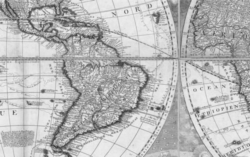
At the beginning of the sixteenth century, most cartographers, following the convention of Ptolemaic world maps, made little distinction between land and sea. They typically represented the ocean as a material, textured space through such techniques as stipling or drawing in waves (). This was a problematic representation, though, for the emergent ideal of the ocean as an empty, external void, because a material ocean presented potential obstacles to movement. Furthermore, such an ocean presumably consisted of places with distinct natures, and these could then be enclosed by boundaries that would serve as further barriers to mobility. If capitalism is built around the fantasy of the “annihilation of space with time” and, in particular, through the designation of empty spaces of movement that are especially amenable to annihilation, then the idea of the ocean as a material, textured space of nature was incompatible with this emergent capitalist ideal. The prevalence of this representation, which might be considered a holdover from medieval perspectives of the ocean as a viscous swamp rather than a wet nothingness (CitationLestringant 1989; CitationCosgrove 2001; CitationGillis 2004), rapidly declined during the study period, peaking in the late sixteenth century and disappearing entirely by 1700 (, bottom frame).
Figure 3 Detail of the Pacific coast of Central America from Ortelius (1570).
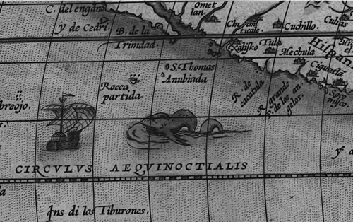
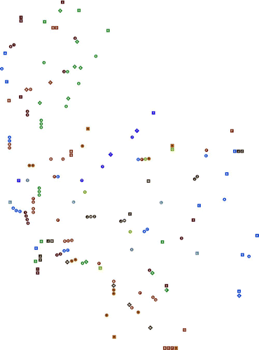
Figure 4 Median number of ships or marine biota per square meter and percentage displaying texture on the ocean, for world maps printed between 1501 and 1800, grouped by twenty-five-year intervals. On ship and biota graphs, a bold line indicates median, a box indicates interquartile range, and “whisker” indicates 1.5 times the interquartile range. Outliers have been omitted to enable presentation at a legible scale.
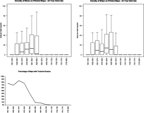
As cartographers began to turn away from representing the ocean as land-like, they nonetheless continued to represent it as a material space of nature and society, highlighting specifically marine characteristics by drawing in generic ships as well as marine biota such as fish and sea monsters (). Although these new representations, which peaked between 1550 and 1650, began to establish the basis for a conceptual distinction between land and sea as practically different kinds of spaces with different features and social processes, they still implied that the ocean, like land, was filled with social processes and natural features and that therefore, like land, it could be bounded, controlled, and organized. Such an image of the ocean was incompatible with the emergent ideal of an ocean beyond society, counterposed against a world of bounded land territories that contain and define fundamental societal units. Thus, by 1700, ships and biota, like stipling and waves, had nearly disappeared from representations of the sea ().Footnote 12
The Seventeenth-Century Ocean: A Space of Routes
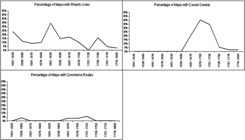
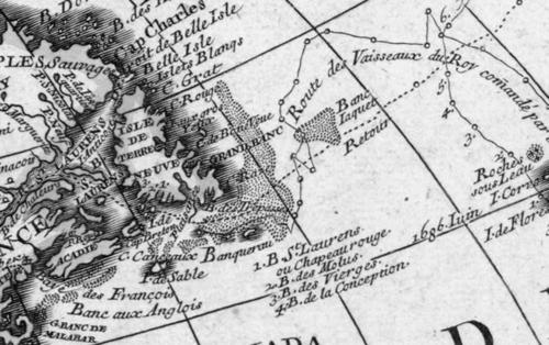
If the sixteenth century was characterized by depictions of the ocean as a space of nature and society, the seventeenth century was dominated by depictions of the ocean as a space of routes. The first of these representations to gain ascendency was the drawing of rhumb lines that, as has been noted, served no navigational purpose on world maps but served to impart the idea that the ocean was a space on which one could navigate by constructing routes through a putatively placeless in-between space (). Rhumb lines, which were most common in the period between 1600 and 1650 but persisted through 1700, were followed by a second depiction, most often occurring between 1650 and 1725, in which the names of basin-based ocean regions (e.g., the South Atlantic for the body of water between the east coast of South America and the west coast of Africa) were replaced by a series of regions defined by coast-hugging arcs (e.g., the Ethiopian Ocean, which arced beneath the African continent, from the South Atlantic to the Indian Ocean; ; see also Lewis 1999). Arced ocean regions, like rhumb lines, suggested that the ocean consisted of a series of routes that could be traveled. This same time period also saw the emergence of a third representation that similarly portrayed the ocean as a space of routes: generic commercial routes, such as the route to the East Indies.
Figure 5 World map from Teixeira (1630).
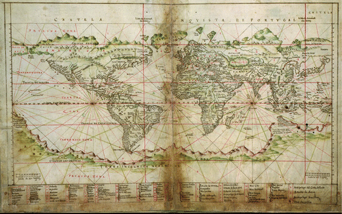
Figure 6 Detail of South America from CitationNolin (1708).
By depicting the ocean as a space of differentiated and functional routes, the ocean was cartographically represented in a manner that closely paralleled its legal designation during the same era as res extra commercium. According to this doctrine, expressed most famously by Grotius ([1608] 1916) in his treatise Mare Liberum, although the ocean provides a resource and thus can be conceived of as property of a sort, it cannot be fully possessed (with all the rights of exclusion and alienation normally associated with property) because the principal resource that it provides—an environment for navigation—is inexhaustible and, as such, is granted to all by natural law (CitationSteinberg 2001).
This conceptualization of the ocean, both in maps of the era and in the legal doctrine of res extra commercium, was transitional. On the one hand, unlike the sixteenth-century depiction of the ocean, the ocean was no longer perceived as consisting of specific points that were rich with nature and that hypothetically could be gathered into territories, enclosed, and developed, like land. On the other hand, although the depiction of the ocean as a space of distinct routes was not the same as land-space, neither was it the antithesis of land. The ocean was still represented as a space of pathways and discrete (if not enclosable) spaces, something more material than the empty and abstract “hyperspace of pure circulation” (CitationCastells 1996, 475) that was to prevail later as a counterpoint to the division of land into bounded territories. Although the specific ways of depicting the ocean as a space of routes waxed and waned during the seventeenth century, all of these depictions had essentially disappeared by 1725 ().
Figure 7 Percentage of world maps printed between 1501 and 1800 displaying rhumb lines, curved oceans, or generic maritime commerce routes, grouped by twenty-five-year intervals.
The Eighteenth-Century Ocean: A Space of Mathematics and Memory
By 1700, a new set of depictions of the ocean had emerged, solidifying the ocean's position as an external void that could serve as a counterpoint to the territorial state. The first of these depictions already had begun to appear early in the seventeenth century: the ecliptic (or zodiac) line (). Much like rhumb lines, the ecliptic line pays homage to the act of navigation without actually enabling navigation. However, unlike rhumb lines or the other navigational signifiers that were common during the previous century (arced ocean regions and generic commerce routes), however, the ecliptic line signifies that the ocean is less a space of discrete routes than an abstract, mathematical, and materially empty space of points that can be crossed at will. Whereas the earlier generation of signifiers that pointed to the ocean as a space of mobility still implied a degree of materiality, social relations, and limits, the ecliptic line suggests that the ocean is a space of pure mathematical abstraction, a dematerialized arena of potentially limitless time–space compression, or idealized annihilation.
Cartographers during the eighteenth century adopted a second means to demonstrate that the ocean was a space of mobility, by depicting the ships and routes of historic explorers such as Columbus, Magellan, and Drake ( and ). In this way, the ocean was presented as a space of movement that achieved its significance not through its contemporary materiality or through ongoing interactions with its nature or even its space but as an arena of history. Depictions of historic explorers’ routes celebrated the ocean—and, in some cases, specific ocean regions or specific historical interactions with the ocean—as a source of national pride and identity formation. At the same time, however, they avoided any implication that the ocean was a space for contemporary social activity or assertions of territorial power. Although explorers’ routes suggested that the ocean was historically significant and the ecliptic line suggested that it could continue to serve society through limitless crossing, these two representations also suggested that it was a space beyond the world of developable places and enclosable state-territories that was emerging on land.
The third ocean representation that was common in the eighteenth century demonstrates the extent to which producers (and, presumably, consumers) of maps had come to accept a distinction between land as a set of developable points, defined by the boundaries of the territorial state, and the ocean as an empty outside that defied territorialization, civilization, or differentiation into “places” of nature and society. The Grand Banks, the highly productive fishing ground off the coast of Newfoundland, on the one hand, had the physical properties of the ocean, but, on the other hand, had the social properties of land as it could be bounded and developed. The Grand Banks thus was a geographic outlier that defied the modern ordering of the world with its division between developable terrestrial territories and a marine nonterritory of mobility. To cope with this outlier space, cartographers of the era borrowed a series of representations that were commonly used on larger scale navigational maps to depict shallows or shoals—shading, stipling, or dotted lines—to depict the Grand Banks as an intermediate space ().
Figure 8 Detail of the Grand Banks from CitationNolin (1708).
Finally, although the focus of this article has been on the construction of the ocean as an unboundable and empty space of movement—an external counterpoint to the emergent idea of the territorial state as a bounded arena of control and development-in-place—it bears noting that the emergence of these final three signifiers that suggest the ocean's status as a space beyond society coincided with the rise of territorial state boundaries on world maps (). Indeed, a generalized linear model applied to the data summarized in (controlling for interyear variance by using the mean value for each year with multiple data points) reveals that the presence of each of these three signifiers is positively correlated with the presence of state boundary lines, and the correlation between the ecliptic line and state boundary lines is significant at the 0.001 level (p = 0.000274). This corresponds with the findings of others who have traced the emergence of state boundary lines from a more traditional perspective that roots the rise of the territorial state in a history of boundary drawing and the designation of “insides” (e.g., CitationSahlins 1989; CitationAkerman 1995; CitationBlack 1997; CitationBrotton 1998; CitationBiggs 1999; CitationKamen 2000; B. CitationAnderson 2006). By 1800, boundary lines that defined both insides and outsides were the norm.
Figure 9 Percentage of world maps printed between 1501 and 1800 displaying the ecliptic line, explorers’ routes, the Grand Banks, or state boundary lines, grouped by twenty-five-year intervals.
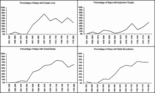
Conclusions
Since the nineteenth century, few cartographers or policymakers have dissented from the dominant view of the ocean as an external space, beyond the world of state-societies. Although CitationMahan (1890) and CitationMackinder (1904) differed greatly in their opinions regarding the geopolitical significance of the ocean—Mahan saw it as the arena on which global dominance would continue to be fought, whereas Mackinder felt that its days as a crucial surface for asserting and projecting force had passed—the perspectives of both geopolitical theorists rested on
an idealization of the sea as an unmanaged and unmanageable surface …that resonates with the spatial assumptions that permeate realist theories of international politics …As unclaimed and unclaimable “international” space, the world-ocean lends itself to being constructed as the space of anarchic competition par excellence, where ontologically pre-existent and essentially equivalent nation-states do battle in unbridled competition for global spoils. (CitationSteinberg 2001, 17)
In other words, both sides of this keystone geopolitical debate accepted the construction of the ocean as a fundamentally external space, a counterpoint to the bounded, terrestrial state within whose borders the anarchy of global competition was contained.
Given the degree to which this externalization of the ocean has been accepted, it is not surprising that one finds few world maps today that display the ocean features that were prevalent in the sixteenth, seventeenth, or eighteenth centuries. By the twentieth century, cartographers had few qualms about making maps that implied that the ocean was fundamentally external to modern society and its foundational territorial units (CitationKonvitz 1979). Indeed, it is noteworthy that few modern “political” world maps depict the political divisions of the ocean—territorial waters, exclusive economic zones, high seas, and so on—instead portraying an undifferentiated, featureless space. This is yet another indication of how, by the twentieth century, there was an accepted distinction between land as the space of sedentarism, civilization, and politics and the ocean as an external, asocial space across which one simply moved.
By the turn of the twenty-first century, the idea of land-space as the domain of bounded, developable insides and the ocean as an external surface for movement had become so entrenched that contemporary cartographers were faced with a representational dilemma similar to the one that had been posed by the Grand Banks: How does one depict Antarctica? Like the Grand Banks, Antarctica has the physical properties of one element (it is solid, like land) but the social properties of the other element (it resists division into sovereign, territorial space, albeit with some dissent). Thus, on the Central Intelligence Agency's (2000) political world map, land is beige (and divided by state boundaries), the ocean is blue (and undivided), and Antarctica, as an outlier space that is not quite land or territory but not quite sea or nonterritory, is designated with a unique, third color: white ().
Figure 10 Political world map by the Central Intelligence Agency (2000).
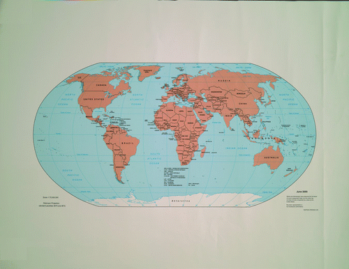
Despite the prevalence of the ocean as external to society in today's cartographic representations, the history narrated in this article reveals that the depiction of the ocean as a space beyond territorialization, and the parallel depiction of land as a series of discrete, bounded territories, was a long time in the making. Indeed, the idea of depicting the ocean as a materially empty wilderness likely was counterintuitive to the mercantilist-era cartographer, both because one would expect a significant space to have a tangible materiality and because cartographers likely were aware that the ocean was not truly an undifferentiated mass devoid of nature. Thus, this history of ocean mapping reveals how, although maps achieve their power by attributing fixed properties to bounded and apparently natural spaces, the act of attempting to fix properties to space (by both the map's producer and its consumer) “offers productive possibilities, particularly through the emergence of constitutive spaces at/in the ‘gaps and fissures’ of the mapping processes” (Del Casino and Hanna 2006, 41). These “gaps and fissures” can occur at specific spaces that defy emergent categorizations (as, for instance, can be seen in the decision to depict spaces like the Grand Banks and Antarctica with intermediate representations that both reproduce and challenge the binary division of the world into social and extrasocial spaces) or they can be more conceptual (as, for instance, in attempts by mercantilist-era cartographers to develop an ideological framework wherein spaces of mobility were perceived as both socially significant and materially empty).
A history of how producers and users of maps attempt to fill these “gaps and fissures” so that they can be placed within a priori categories of inside and outside, fixity and mobility, and social and extrasocial, and how these “gaps and fissures” nonetheless reappear, suggests that the study and practice (or performance) of cartography can play an important role in generating new perspectives on the categories and institutions that define modern society. As CitationKwan (2007) notes, a range of alternative visualization practitioners, from advocates of consciousness-raising participatory geographic information systems to situationist members of the art-and-cartography movement, have made this assertion. Perhaps it is not surprising that so many of these individuals’ experiments with alternative modes of visualization focus on mobility. As the examples discussed here have shown, it is difficult to represent spaces of mobility in a manner that simultaneously portrays the experience of movement, the metric space through which one is moving, the idealized immateriality of that space, the actual materiality of that space, and the space's significance in the reproduction of social institutions that go beyond the practices or designated spaces of mobility. Thus, the depiction of mobility has emerged as an arena not just for gaining new insights on the world, but also for advancing cartographic practice.
Kwan's (2008) work is representative of these experiments in cartographic representation, as she combines the representational practices of time-geography with an attempt to depict the subjective perceptions and emotions of individuals moving through an urban environment (in this case, Muslim women in Columbus, Ohio). This work is exemplary not just because Kwan attempts to portray the experiences of individuals. It is also significant because, in representing these experiences, Kwan reconstitutes the city not as a series of points with ontologically prior characteristics but as a series of affect-laden surfaces with meanings that are realized by the individual as he or she moves across them (or, in instances when the space is perceived as too dangerous, as he or she contemplates moving across them).
In bringing mobility to the center of her mapping of both personal and urban spaces, Kwan aligns herself with a growing number of scholars who stress that mobility is a constitutive social practice (CitationHannam, Sheller, and Urry 2006). As this article has suggested, this new focus on mobility has far-reaching ramifications: Recentering movement (and the subjective experiences that emerge as one moves) involves rethinking a series of cartographic as well as political norms that have developed over hundreds of years and that underlie the very foundation of modern society.
Thus, this article suggests two related agendas for further research. In one sense, this article has called for inverting foreground and background on our maps. Instead of focusing attention on the bounded land territories that we take for granted as the spaces of society, what would happen if we foregrounded the spaces across which people (and commodities, information, and capital) move, so that they become conceived of as something other than the residual spaces that are left “outside” society? As this study has shown, the designation of some spaces as external spaces of mobility has played a key role in the ways in which we order our world, including the ways in which we bound and order the “inside” spaces in which mobility is purported to play only a secondary role. Although cultural studies and critical development theorists have for some time focused on the processes by which cultures are designated as “others” that are in need of development (e.g., CitationSaid 1978), much less attention has been devoted to the processes by which some of the world's spaces have been designated as being so “outside” that they lack even the potential for development. Historically, the construction of the modern system of territorial states has also involved the designation of outsides as being beyond territorial control, and as one studies the processes of drawing (and ascribing meaning to) boundary lines, one must focus on the construction of outsides as well as insides. Furthermore, this process has not ended with the formation of the juridical ideal of the modern, sovereign, territorial nation-state. There are numerous configurations by which spaces and peoples can be constructed as inside or outside the protection of the state, and this is as much a process of constructing outsides as it is one of constructing insides.Footnote 13
This agenda, however, also suggests a second, more radical agenda where, instead of tracing the historic externalization of a specific space (like the ocean) or social function (like mobility), we revision a world without distinct insides and outsides. Under this agenda, one would go beyond bringing externalized spaces of mobility to the foreground. Instead, one would consider that, in fact, all spaces are spaces of both mobility and fixity and all social processes are driven by ideologies of both internalization and externalization. This is an ambitious agenda. Analytical thought, after all, involves differentiating, comparing, and drawing “lines” of contrast. A first step, however, might well involve erasing the boundaries on our maps that divide inside from outside. Perhaps then we can begin working from behind the lines.
Acknowledgments
Research for this article was supported by a John S. Best Fellowship from the American Geographical Society Collection at the University of Wisconsin–Milwaukee, a Short Term Fellowship in the History of Cartography from the Newberry Library, a fellowship from the Dorothy and Lewis B. Cullman Center for Scholars and Writers at the New York Public Library, an Arthur and Janet Holzheimer Fellowship from the Institute for Research in the Humanities and the History of Cartography Project at the University of Wisconsin–Madison, and an Other Globalizations Fellowship from the Center for Cultural Studies at the University of California–Santa Cruz.
In addition, I am grateful for comments and questions from audience members at presentations of earlier versions of this article at Rutgers, Lund, Princeton, and Louisiana State Universities, the National University of Singapore, and the Universities of Washington, Wisconsin–Milwaukee, and California–Santa Cruz. Additional thanks go to Seth Bassett, Barbie Bischof, Mei-Po Kwan, and the anonymous reviewers for comments on final drafts of this article, with further thanks to Seth Bassett for assistance in preparing graphics and conducting statistical analysis.
Notes
1. Some of the classics in this literature include Anzaldua (1987), CitationButler (1990), CitationGilroy (1993), CitationBhabha (1994), CitationAppadurai (1996a), CitationClifford (1997), CitationGupta and Ferguson (1997), CitationOng (1998), and CitationTsing (2004). Of particular interest here are scholars who have used this perspective to question the ontology of the sovereign, territorial state, such as CitationShapiro and Alker (1995), CitationNewman (1999), CitationAlbert, Jacobson, and Lapid (2001), CitationSparke (2005), and CitationRajaram and Grundy-Warr (2007).
2. CitationPrice (2004) makes a similar point, specifically with reference to critical borderland studies. See also CitationCresswell (2006).
3. By 1755 the territorial demarcation of states on maps had been normalized to the point that Robert de Vaugondy felt it necessary to apologize for the omission of San Marino from his map of Europe because of its small size, even though “the republic of San Marino carries as much authority in its territory as the republic of Venice in its own” (cited in CitationJacob 2006, 75).
4. State formation and territorialization—and the adoption of an abstract-relational perspective regarding one's homeland—also require participation from “below,” which makes the entire process much more contingent and unpredictable. See, for instance, discussions on the potential for countermapping as a means of constructing narratives and land-tenure relations outside the state discourse that presupposes interchangeable points on an abstract grid (CitationPeluso 1995; CitationSparke 1998; CitationSt. Martin 2001; CitationWalker and Peters 2001; CitationFox 2002; CitationHodgson and Schroeder 2002) and, more generally, discussions of how mapping as a process involves participation by the map user as well as the mapmaker (CitationKitchin and Dodge 2007).
5. CitationTodorov (1984) makes a similar argument with regard to the role of written language.
6. This point is elaborated on, with reference to the world of electronic communications, in CitationMcDowell, Steinberg, and Tomasello (2008).
7. This deficiency is exemplified by de Certeau's (1991, 120) remark that the mappamundi is “not a ‘geographical map’ but ‘history book'” and is in keeping with his more general tendency to set a dynamic conception of time against a static conception of space (CitationMassey 2005).
8. The decline in ocean-region names during the sixteenth century is discussed later in this article.
9. CitationKitchin and Dodge (2007) make much the same point when arguing for a focus on “mappings” in which the map is continually reproduced by the user.
10. Shirley identifies 628 known printed world maps from 1501 on (1501 was used as the start date because there are no known printed world maps from the period between 1492 and 1500). Of these, 214 were excluded because the Shirley book did not contain a legible reproduction (in most cases, Shirley had chosen not to reproduce these maps because they were almost identical to maps that he did reproduce). Two additional maps were excluded because, notwithstanding their appearance in the Shirley volume, they were not, in fact, printed world maps.
In addition, because the goal of this project was to document prevailing worldviews of the time, I excluded maps that sought to reproduce some other era's cosmology, and thus I omitted thirteen maps reproduced by Shirley that had been created specifically to reproduce a classical or medieval map type or illustrate a biblical story or a metaphysical principle. Likewise, because my aim was to reproduce changes in the representation of the ocean as an “outside,” I omitted two maps reproduced by Shirley that were explicitly oceanographic in content. Finally, my goal was to trace the evolution of the “Western” worldview, a problematic perspective in that it assumes a “West” that is both unified and isolated. Nonetheless, given that the modern state system (and the idea of the territorial state with an extraterritorial outside) was a “Western” invention, even if it was one that subsequently has been modified and even influenced by non-Western societies (e.g., CitationThongchai 1994), I somewhat arbitrarily defined Western maps as those that used Latin lettering, leading to the exclusion of a further four maps, one each in Russian, Turkish, Armenian, and Greek.
11. The four libraries utilized were the American Geographical Society Library, the New York Public Library, the Newberry Library, and various libraries at the University of Wisconsin–Madison (including the Wisconsin Historical Society).
12. As CitationJacob (2006) notes, both de Certeau and Latour discuss the disappearance of ships on world maps, speculating that the ships had been depicted to pay homage to the process by which the world (and the ocean) came to be known and that their disappearance attested to geographical knowledge and its representation being taken for granted. However, the close correspondence between the rise and fall of representations of ships with the rise and fall of marine biota suggests otherwise. A correlation analysis run on the raw data (not aggregated into twenty-five-year intervals) reveals a positive correlation between the number of ships and the number of biota, with an extremely significant p value of 2.220- 16. This correlation suggests that the ships, rather than representing the process by which the ocean came to be known, simply represented the ideal that the ocean was a space of social processes as well as natural features.
13. See, for instance, Gaynor's (2007) study of the Indonesian government's attitudes toward that country's outlying islands, the people who inhabit these islands, and the ocean that connects (and separates) Java from these islands. See also work that applies CitationAgamben (1998) to the U.S. Global War on Terror and its extraterritorial interrogation and detention centers (CitationAgamben 2004; CitationButler 2004; CitationGregory and Pred 2007).
Related Research Data
References
- Abrams , P. 1988 . Notes on the difficulty of studying the state . Journal of Historical Sociology , 1 : 58 – 89 .
- Agamben , G. 1998 . Homo sacer: Sovereign power and bare life. , Palo Alto, CA : Stanford University Press .
- Agamben , G. 2004 . State of exception. , Chicago : University of Chicago Press .
- Agnew , J. 1994 . The territorial trap: The geographical assumptions of international relations theory . Review of International Political Economy , 1 : 53 – 80 .
- Akerman , J. R. 1984 . “ Cartography and the emergence of territorial states in western Europe ” . In Proceedings of the tenth annual meeting of the Western Society for French History, 14–16 October 1982, Winnipeg , Edited by: Sweets , J. F. 84 – 93 . Lawrence : University of Kansas .
- Akerman , J. R. 1995 . The structuring of political territory in early printed atlases . Imago Mundi , 47 : 138 – 54 .
- Akerman , J. R. 2006 . “ Introduction ” . In Cartographies of travel and navigation , Edited by: Akerman , J. R. 1 – 15 . Chicago : University of Chicago Press .
- Albert , M. 1999 . “ On boundaries, territory, and postmodernity: An international relations perspective ” . In Boundaries, territory, and postmodernity , Edited by: Newman , D. 53 – 68 . London : Frank Cass .
- Albert , M. , Jacobson , D. and Lapid , Y. 2001 . Identities borders orders: Rethinking international relations theory. , Minneapolis : University of Minnesota Press .
- Alliès , P. 1980 . L'invention du territoire [The invention of territory] , Grenoble, , France : Presses Universitaires de Grenoble .
- Anderson , B. 2006 . Imagined communities: Reflections on the origin and spread of nationalism. Rev. ed. , London : Verso .
- Anderson , M. 1996 . Frontiers: Territory and state formation in the modern world. , Cambridge, , UK : Polity .
- Anzaldúa , G. 1987 . Borderlands/La Frontera: The new Mestiza. , San Francisco : Spinsters .
- Appadurai , A. 1996a . Modernity at large: Cultural dimensions of globalization. , Minneapolis : University of Minnesota Press .
- Appadurai , A. 1996b . “ Sovereignty without territoriality: Notes for a postnational geography ” . In The geography of identity , Edited by: Yeager , P. 40 – 58 . Ann Arbor : University of Michigan Press .
- Armstrong , J. A. 1982 . Nations before nationalism. , Chapel Hill : University of North Carolina Press .
- Bartelson , J. 1995 . A genealogy of sovereignty. , Cambridge, , UK : Cambridge University Press .
- Bender , T. 2006 . A nation among nations: America's place in world history. , Boston : Hill & Wang .
- Bhabha , H. 1994 . The location of culture. , London and New York : Routledge .
- Biagini , E. and Hoyle , B. 1999 . “ Insularity and development on an oceanic planet ” . In Insularity and development: International perspectives on islands , Edited by: Biagini , E. and Hoyle , B. 1 – 14 . London : Pinter .
- Biggs , M. 1999 . Putting the state on the map . Comparative Studies in Society and History , 41 : 374 – 405 .
- Black , J. 1997 . Maps and history: Constructing images of the past. , New Haven, CT : Yale University Press .
- Bohannan , P. 1964 . Africa and Africans. , Garden City, NY : Natural History Press .
- Brotton , J. 1998 . Trading territories: Mapping the early modern world. , Ithaca, NY : Cornell University Press .
- Brown , M. and Knopp , L. 2008 . Queering the map: The productive tensions of colliding epistemologies . Annals of the Association of American Geographers , 98 : 40 – 58 .
- Buisseret , D. 1992 . Monarchs, ministers, and maps. , Chicago : University of Chicago Press .
- Burch , K. 1994 . “ The “properties” of the state system and global capitalism ” . In The global economy as political space , Edited by: Rosow , S. J. , Inayatullah , N. and Rupert , M. 37 – 59 . Boulder, CO : Lynne Rienner .
- Burnett , D. G. 2000 . Masters of all they surveyed. , Chicago : University of Chicago Press .
- Butler , J. 1990 . Gender trouble. , London and New York : Routledge .
- Butler , J. 2004 . Precarious life: The powers of mourning and violence. , London : Verso .
- Campbell , D. 1998 . Writing security: United States foreign policy and the politics of identity. , Minneapolis : University of Minnesota Press . Rev. ed.
- Carter , P. 1987 . The road to Botany Bay. , London : Faber & Faber .
- Carter , P. 1996 . The lie of the land. , London : Faber & Faber .
- Casey , E. S. 2002 . Representing place: Landscape painting and maps. , Minneapolis : University of Minnesota Press .
- Casey , E. S. 2005 . Earth-mapping: Artists reshaping landscape. , Minneapolis : University of Minnesota Press .
- Castells , M. 1996 . The rise of the network society. , Oxford, , UK : Blackwell .
- Agency Central Intelligence . 2000 . Political world map, June 2000. , Langley, VA : Central Intelligence Agency . http://www.lib.utexas.edu/maps/world_maps/world_pol_2000.pdf (last accessed 1 June 2008)
- Chilton , P. A. 1996 . Security metaphors: Cold war discourse from containment to common house. , New York : Peter Lang .
- Clifford , J. 1997 . Routes: Travel and translation in the late twentieth century. , Cambridge, MA : Harvard University Press .
- Conley , T. 1996 . The self-made map: Cartographic writing in early modern France. , Minneapolis : University of Minnesota Press .
- Connery , C. 2001 . Ideologies of land and sea: Alfred Thayer Mahan, Carl Schmitt, and the shaping of global myth elements . Boundary , 2 ( 28 ) : 173 – 201 .
- Connery , C. 2006 . There was no more sea: The supersession of the ocean from the Bible to cyberspace . Journal of Historical Geography , 32 : 494 – 511 .
- Cosgrove , D. 2001 . Apollo's eye: A cartographic genealogy of the Earth in the western imagination. , Baltimore : Johns Hopkins University Press .
- Cosgrove , D. 2006 . Art and mapping . Cartographic Perspectives , 53 : 4
- Craib , R. 2000 . Cartography and power in the conquest and creation of New Spain . Latin American Research Review , 35 : 7 – 36 .
- Crampton , J. 2003 . The political mapping of cyberspace. , Edinburgh, , UK : Edinburgh University Press .
- Cresswell , T. 2006 . On the move: Mobility in the modern western world. , London and New York : Routledge .
- Curry , M. 2005 . Toward a geography of a world without maps: Lessons from Ptolemy and postal codes . Annals of the Association of American Geographers , 95 : 680 – 91 .
- De Certeau , M. 1991 . The practice of everyday life. , Berkeley : University of California Press .
- Delano-Smith , C. 2006 . “ Milieux of mobility: Itineraries, route maps, and road maps ” . In Cartographies of travel and navigation , Edited by: Akerman , J. R. 16 – 68 . Chicago : University of Chicago Press .
- Del Casino , V. J. Jr and Hanna , S. P. 2006 . Beyond the “binaries”: A methodological intervention for interrogating maps as representational practices . ACME: An International E-Journal for Critical Geographies , 4 : 34 – 56 .
- Deleuze , G. 1988 . Bergsonism. , New York : Zone .
- Deleuze , G. and Guattari , F. 1988 . A thousand plateaus: Capitalism and schizophrenia. , London : Athlone .
- Dettelbach , M. 1996 . “ Global physics and aesthetic empire: Humboldt's physical portrait of the tropics ” . In Visions of empire: Voyages, botany, and representations of nature , Edited by: Miller , D. P. and Reill , P. H. 258 – 92 . Cambridge, , UK : Cambridge University Press .
- Dilke , O. A. W. 1987 . “ The culmination of Greek cartography in Ptolemy ” . In Cartography in prehistoric, ancient and medieval Europe and the Mediterranean. Vol. 1 of The history of cartography , Edited by: Harley , J. B. and Woodward , D. 177 – 200 . Chicago : University of Chicago Press .
- Edney , M. 1997 . Mapping an empire. , Chicago : University of Chicago Press .
- Edson , E. 2007 . The world map, 1300–1492: The persistence of tradition and transformation. , Baltimore : Johns Hopkins University Press .
- Elden , S. 2005 . Missing the point: Globalization, deterritorialization, and the space of the world . Transactions of the Institute of British Geographers , 30 : 8 – 19 .
- Elden , S. 2006 . Speaking against number: Heidegger, language and the politics of calculation. , Edinburgh, , UK : Edinburgh University Press .
- Foucault , M. 1973 . The order of things. , New York : Vintage .
- Foucault , M. 2007 . Security, territory, population. , New York : Palgrave Macmillan .
- Fox , J. 2002 . Siam mapped and mapping in Cambodia: Boundaries, sovereignty, and indigenous conceptions of space . Society & Natural Resources , 15 : 65 – 78 .
- Gaynor , J. 2007 . “ Maritime ideologies and ethnic anomalies: Sea space and the structure of subalternity in the Southeast Asian littoral ” . In Seascapes: Maritime histories, littoral cultures, and transoceanic exchanges , Edited by: Bentley , J. H. , Bridenthal , R. and Wigen , K. 53 – 70 . Honolulu : University of Hawai'i Press .
- Giddens , A. 1985 . The nation-state and violence. , London : Polity . Vol. 2 of A contemporary critique of historical materialism.
- Gillis , J. R. 2004 . Islands of the mind: How the human imagination created the Atlantic world. , New York : Palgrave Macmillan .
- Gillis , J. R. 2007 . “ Islands in the making of an Atlantic Oceania, 1500–1800 ” . In Seascapes: Maritime histories, littoral cultures, and transoceanic exchanges , Edited by: Bentley , J. H. , Bridenthal , R. and Wigen , K. 21 – 37 . Honolulu : University of Hawai'i Press .
- Gilroy , P. 1993 . The black Atlantic: Modernity and double consciousness. , Cambridge, MA : Harvard University Pres .
- Gottman , J. 1973 . The significance of territory. , Charlottesville : University of Virginia Press .
- Gregory , D. and Pred , A. 2007 . Violent geographies: Fear, terror, and political violence. , London and New York : Routledge .
- Grosz , E. A. 1995 . Space, time, and perversion: Essays on the politics of bodies. , London and New York : Routledge .
- Grotius , H. 1916 . The freedom of the seas, or the right which belongs to the Dutch to take part in the East Indian trade. , Edited by: van Deman , R. Magoffin . New York : Oxford University Press .
- Gupta , A. and Ferguson , J. 1997 . Culture, power, place: Explorations in critical anthropology. , Durham, NC : Duke University Press .
- Häkli , J. 2001 . In the territory of knowledge: State-centred discourses and the construction of society . Progress in Human Geography , 25 : 403 – 22 .
- Hanna , S. , Casino , V. J. , Del Selden , C. Jr and Hite , B. 2004 . Representation as work in “America's most historic city.' . Social and Cultural Geography , 5 : 459 – 82 .
- Hannam , K. , Sheller , M. and Urry , J. 2006 . Editorial: Mobilities, immobilities and moorings . Mobilities , 1 : 1 – 22 .
- Hardt , M. and Negri , A. 2001 . Empire. , Cambridge, MA : Harvard University Press .
- Harley , J. B. 2001 . The new nature of maps. , Baltimore : Johns Hopkins University Press .
- Harley , J. B. , Woodward , D. and Lewis , G. M. 1992–1998 . The history of cartography. , Vol. 2 , Chicago : University of Chicago Press .
- Harris , L. M. and Hazen , H. D. 2006 . Power of maps: (Counter)mapping for conservation . ACME: An International E-Journal for Critical Geographies , 4 : 99 – 130 .
- Harvey , F. 2006 . Reconfiguring administrative geographies in the United States . ACME: An International E-Journal for Critical Geographies , 4 : 57 – 79 .
- Hinsley , F. H. 1986 . Sovereignty. , 2nd ed. , Cambridge, , UK : Cambridge University Press .
- Hodgson , D. L. and Schroeder , R. A. 2002 . Dilemmas of counter-mapping community resources in Tanzania . Development and Change , 33 : 79 – 100 .
- Hugill , P. J. 1993 . World trade since 1431: Geography, technology and capitalism. , Baltimore : Johns Hopkins University Press .
- Jacob , C. 2006 . The sovereign map: Theoretical approaches in cartography throughout history. , Chicago : University of Chicago Press .
- Johnson , D. S. 1994 . Phantom islands of the Atlantic: The legends of seven lands that never were. , Fredericton, NB, , Canada : Goose Lane .
- Kain , R. J. P. and Baigent , E. 1992 . The cadastral map in the service of the state: A history of property mapping. , Chicago : University of Chicago Press .
- Kamen , H. 2000 . Early modern European society. , London and New York : Routledge .
- Katchadourian , N. 1996 . Hand-held subway. http://www.ninakatchadourian.com/maps/handheldsubway.php (last accessed 1 June 2008).
- Keohane , R. O. 2002 . Power and governance in a partially globalized world. , London and New York : Routledge .
- Kitchin , R. and Dodge , M. 2007 . Rethinking maps . Progress in Human Geography , 31 : 331 – 44 .
- Knutzen , M. 2000 . Subway map. [Reproduction available from the artist.]
- Konvitz , J. 1979 . Changing conceptions of the sea: 1550–1950 . Terrae Incognitae , 11 : 1 – 17 .
- Krasner , S. D. 1993 . “ Westphalia and all that ” . In Ideas and foreign policy: Beliefs, institutions, and political change , Edited by: Goldstein , J. and Keohane , R. O. 235 – 64 . Ithaca, NY : Cornell University Press .
- Kratochwil , F. 1986 . Of systems, boundaries, and territoriality . World Politics , 39 : 27 – 52 .
- Kwan , M.-P. 2007 . Affecting geospatial technologies: Toward a feminist politics of emotion . The Professional Geographer , 59 : 22 – 34 .
- Kwan , M.-P. 2008 . From oral histories to visual narratives: Re-presenting the post-September 11 experiences of the Muslim women in the USA . Social and Cultural Geography , 9 : 653 – 69 .
- Latour , B. 1986 . “ Visualization and cognition ” . In Knowledge and society , Edited by: Kuklick , H. and Long , E. 1 – 40 . Westport, CT : JAI .
- Latour , B. 1987 . Science and action: How to follow scientists and engineers through society. , Cambridge, MA : Harvard University Press .
- Law , J. 1986 . “ On the methods of long-distance control ” . In Power, action, and belief , Edited by: Law , J. 234 – 63 . London and New York : Routledge .
- Law , J. 2002 . Objects and spaces . Theory, Culture, & Society , 19 : 91 – 105 .
- Lefebvre , H. 1991 . The production of space. , Oxford, , UK : Blackwell .
- Lestringant , F. 1989 . “ Îles [Islands] ” . In Géographie du monde au moyen age et à la renaissance [World geography in the Middle Ages and the Renaissance] , Edited by: Pelletier , M. 165 – 67 . Paris : Editions du Comité des Travaux Historiques et Scientifiques .
- Lewis , M. 1999 . Dividing the ocean sea . Geographical Review , 89 : 188 – 214 .
- Sir Mackinder , H. J. 1904 . The geographical pivot of history . The Geographical Journal , 23 : 421 – 27 .
- MacRae , A. 2005 . Counterpoint: The Westphalia overstatement . International Social Science Review , 80 : 159 – 65 .
- Mahan , A. T. 1890 . The influence of sea power upon history , 1660 – 1783 . Boston : Little Brown .
- Maier , C. S. 2000 . Consigning the twentieth century to history: Alternative narratives for the modern era . American Historical Review , 105 : 807 – 31 .
- Mancke , E. 1999 . Early modern expansion and the politicization of oceanic space . Geographical Review , 89 : 225 – 36 .
- Mann , M. 1984 . The autonomous powers of the state . Archives Européennes de Sociologie , 25 : 185 – 213 .
- Marx , K. 1973 . Grundrisse: Foundations of the critique of political economy. , London : Allen Lane/NLR .
- Massey , D. 2005 . For space. , London : Sage .
- McDowell , S. D. , Steinberg , P. E. and Tomasello , T. K. 2008 . Managing the infosphere: Governance, technology, and cultural practice in motion. , Philadelphia : Temple University Press .
- Mignolo , W. 1995 . The darker side of the Renaissance. , Ann Arbor : University of Michigan Press .
- Mitchell , K. 1997 . Transnational discourse: Bringing geography back in . Antipode , 29 : 101 – 14 .
- Mitchell , T. 1991 . The limits of the state: Beyond statist approaches and their critics . American Political Science Review , 85 : 77 – 96 .
- Mitchell , T. 1999 . “ State, economy, and the state effect ” . In State/culture: State formation after the cultural turn , Edited by: Steinmetz , G. 76 – 97 . Ithaca, NY : Cornell University Press .
- Newman , D. 1999 . Boundaries, territory, and postmodernity. , London : Frank Cass .
- Nolin , J. B. 1708 . Le globe terrestre représenté en deux plans-hémisphères [World map in two hemispheres] http://hdl.loc.gov/loc.gmd/g3200.ct001475 (last accessed 1 June 2008).
- Tuathail , G. Ó . 1996 . Critical geopolitics: The politics of writing global space. , Minneapolis : University of Minnesota Press .
- Ong , A. 1998 . Flexible citizenship: The cultural logics of transnationality. , Durham, NC : Duke University Press .
- Ortelius , A. 1570 . Theatrum orbis terrarium [Theater of the world] http://hdl.loc.gov/loc.gmd/g3200m.gct00003 (last accessed 1 June 2008).
- Painter , J. 2006 . Prosaic geographies of stateness . Political Geography , 25 : 752 – 74 .
- Parry , J. H. 1974 . The discovery of the sea. , New York : Dial .
- Peluso , N. L. 1995 . Whose woods are these? Counter-mapping forest territories in Kalimantan, Indonesia . Antipode , 27 : 383 – 406 .
- Pickles , J. 2003 . A history of spaces: Cartographic reason, mapping, and the geo-coded world. , London and New York : Routledge .
- Price , P. 2004 . Dry place: Landscapes of belonging and exclusion. , Minneapolis : University of Minnesota Press .
- Rajaram , P. K. and Grundy-Warr , C. 2007 . Borderscapes: Hidden geographies and politics at territories edge. , Minneapolis : University of Minnesota Press .
- Richards , T. 1993 . The imperial archive: Knowledge and the fantasy of empire. , New York : Verso .
- Rubenstein , S. 2001 . Colonialism, the Shuar Federation, and the Ecuadorian state . Environment and Planning D: Society & Space , 19 : 263 – 93 .
- Ruggie , J. G. 1983 . Continuity and transformation in the world polity: Toward a neorealist synthesis . World Politics , 35 : 261 – 85 .
- Ruggie , J. G. 1993 . Territoriality and beyond: Problematizing modernity in international relations . International Organization , 47 : 139 – 74 .
- Ryan , S. 1996 . The cartographic eye. , Cambridge, , UK : Cambridge University Press .
- Sack , R. D. 1986 . Human territoriality: Its theory and history , Cambridge, , UK : Cambridge University Press .
- Sahlins , P. 1989 . Boundaries. , Berkeley : University of California Press .
- Said , E. W. 1978 . Orientalism. , New York : Vintage .
- Said , E. W. 1993 . Culture and imperialism. , New York : Vintage .
- Salter , M. B. 2003 . Rights of passage: The passport in international relations. , Boulder, CO : Lynne Rienner .
- Schmitt , C. 2006a . Political theology: Four chapters on the concept of sovereignty. , Chicago : University of Chicago Press .
- Schmitt , C. 2006b . The nomos of the Earth in the international law of the Jus Publicum Europaeum , New York : Telos .
- Scott , J. 1998 . Seeing like a state: How certain schemes to improve the human condition have failed. , New Haven, CT : Yale University Press .
- Seed , P. 1995 . Ceremonies of possession in Europe's conquest of the new world. , Cambridge, , UK : Cambridge University Press .
- Shapiro , M. and Alker , H. 1995 . Challenging boundaries: Global flows, territorial identities. , Minneapolis : University of Minnesota Press .
- Sharp , J. P. 2001 . Condensing the cold war: Reader's Digest and American identity. , Minneapolis : University of Minnesota Press .
- Shirley , R. W. 2001 . The mapping of the world: Early printed world maps, 1472–1700. , 4th ed , Riverside, CT : Early World Press .
- Sidaway , J. D. and Power , M. 2005 . “The tears of Portugal”: Empire, identity, “race” and destiny in Portuguese geopolitical narratives . Environment and Planning D: Society & Space , 23 : 527 – 54 .
- Soja , E. W. 1971 . The political organization of space. , Washington, DC : Association of American Geographers .
- Soja , E. W. 1980 . The socio-spatial dialectic . Annals of the Association of American Geographers , 70 : 207 – 25 .
- Sparke , M. 1998 . A map that roared and an original atlas: Canada, cartography, and the narration of nation . Annals of the Association of American Geographers , 88 : 463 – 95 .
- Sparke , M. 2005 . In the space of theory: Post-foundational geographies of the nation-state. , Minneapolis : University of Minnesota Press .
- Spruyt , H. 1994 . The sovereign state and its competitors: An analysis of systems change. , Princeton, NJ : Princeton University Press .
- St. Martin , K. 2001 . Making space for community resource management in fisheries . Annals of the Association of American Geographers , 91 : 122 – 42 .
- Steinberg , P. E. 1999a . Lines of division, lines of connection: Stewardship in the world ocean . Geographical Review , 89 : 254 – 64 .
- Steinberg , P. E. 1999b . The maritime mystique: Sustainable development, capital mobility, and nostalgia in the world ocean . Environment and Planning D: Society & Space , 17 : 403 – 26 .
- Steinberg , P. E. 2001 . The social construction of the ocean. , Cambridge, , UK : Cambridge University Press .
- Steinberg , P. E. 2005 . Insularity, sovereignty, and statehood: The representation of islands on portolan charts and the construction of the territorial state . Geografiska Annaler B , 87 : 253 – 65 .
- Steinberg , P. E. 2006 . Calculating similitude and difference: John Seller and the “placing” of English subjects in a global community of nations . Social & Cultural Geography , 7 : 687 – 707 .
- Steinberg , P. E. and McDowell , S. D. 2003 . Global communication and the post-statism of cyberspace: A spatial constructivist view . Review of International Political Economy , 10 : 196 – 221 .
- Strandsbjerg , J. 2008 . The cartographic production of territorial space: Mapping and state formation in early modern Denmark . Geopolitics , 13 : 335 – 58 .
- Strayer , J. 1970 . On the medieval origins of the modern state. , Princeton, NJ : Princeton University Press .
- Taylor , P. J. 1994 . The state as container . Progress in Human Geography , 18 : 151 – 62 .
- Taylor , P. J. 1995 . Beyond containers: Internationality, interstateness, interterritoriality . Progress in Human Geography , 19 : 1 – 15 .
- Teixeira , J. 1630 . Taboas geraes de toda a navegação [General charts for world navigation] http://hdl.loc.gov/loc.gmd/g3200m.gct00052 (last accessed 1 June 2008).
- Thomson , J. E. 1994 . Mercenaries, pirates, and sovereigns: State-building and extraterritorial violence in early modern Europe. , Princeton, NJ : Princeton University Press .
- Thongchai , W. 1994 . Siam mapped: A history of the geo-body of a nation. , Honolulu : University of Hawai'i Press .
- Tilly , C. 1975 . The formation of nation-states in western Europe. , Princeton, NJ : Princeton University Press .
- Todorov , T. 1984 . The conquest of America: The question of the other. , New York : Harper & Row .
- Tsing , A. L. 2004 . Friction: A global ethnography of connection. , Princeton, NJ : Princeton University Press .
- Turnbull , D. 1989 . Maps are territories, science is an atlas. , Chicago : University of Chicago Press .
- Turnbull , D. 1996 . Geography and science in early modern Europe: Mapping and the construction of knowledge spaces . Imago Mundi , 48 : 5 – 24 .
- Vance , J. E. Jr . 1990 . Capturing the horizon: The historical geography of transportation since the sixteenth century. , Baltimore : Johns Hopkins University Press .
- Vandergeest , P. and Peluso , N. L. 1995 . Territorialization and state power in Thailand . Theory and Society , 24 : 385 – 426 .
- Virilio , P. 1986 . Speed and politics: An essay on dromology. , New York : Semiotext(e) .
- Virilio , P. 1997 . Open sky. , London : Verso .
- Walker , P. A. and Peters , P. E. 2001 . Maps, metaphors, and meanings: Boundary struggles and village forest use on private and state land in Malawi . Society & Natural Resources , 14 : 411 – 24 .
- Walker , R. B. J. 1993 . Inside/outside: International relations as political theory. , Cambridge, , UK : Cambridge University Press .
- Williams , J. E. D. 1992 . From sails to satellites: The origin and development of navigational science. , Oxford, , UK : Oxford University Press .
- Wood , D. 2006 . Map art . Cartographic Perspectives , 53 : 5 – 14 .
- Woodward , D. 1985 . Reality, symbolism, time, and space in medieval world maps . Annals of the Association of American Geographers , 75 : 510 – 21 .
- Woodward , D. 1987a . Art and cartography: Six historical essays. , Chicago : University of Chicago Press .
- Woodward , D. 1987b . “ Medieval mappaemundi. ” . In Cartography in prehistoric, ancient and medieval Europe and the Mediterranean. Vol. 1 of The history of cartography , Edited by: Harley , J. B. and Woodward , D. 286 – 370 . Chicago : University of Chicago Press .
- Woodward , D. 1990 . Roger Bacon's terrestrial coordinate system . Annals of the Association of American Geographers , 80 : 109 – 22 .