
ABSTRACT
Capsule: There were up to 6348 Ring Ouzel territories in the UK in 2012.
Aims: To produce estimates of the size of the Ring Ouzel breeding population in the UK and its constituent countries.
Methods: A stratified random selection of tetrads was surveyed within the known breeding range, except for the remaining breeding areas on Dartmoor and historical sites elsewhere, which were surveyed in their entirety. The methods followed those devised for the first UK-wide survey in 1999, using playback of song at specific points along tetrad transect lines.
Results: The UK population estimate in 2012 was 5332 (95% confidence limits (CL), 4096–6875) territories, a non-significant decline of 29% since 1999. There were no significant differences in the population changes in England, Scotland and Wales between the two surveys. An estimation of survey efficiency found that 84% of territories were located by the national survey methods, suggesting that the UK population in 2012 could have been as many as 6348 (95% CL, 4825–8198) territories.
Conclusion: The results suggest that the UK Ring Ouzel population has continued to decline since 1999. Ongoing and future research should determine where the main threats to the population are: on the breeding or wintering grounds, or during migration.
The Ring Ouzel Turdus torquatus is a summer visitor to upland areas of the UK, where it is typically found on steep rocky hillsides and in gullies (Cramp Citation1988). The global breeding range covers mountainous areas of Europe and Southwest Asia. There are three races, with the nominate Turdus t. torquatus breeding in Britain and Ireland and in Fennoscandia, Turdus t. alpestris in central and southern Europe, and Turdus t. amicorum in Southwest Asia (Cramp Citation1988). The wintering range for T. t. torquatus encompasses Northwest Africa and southern Spain, with the bulk of the population found in the Atlas Mountains in Northwest Africa (Wernham et al. Citation2002). In Fennoscandia and central and southern Europe, Ring Ouzel populations were thought to be stable (Tucker & Heath Citation1994, Hagemeijer & Blair Citation1997), although the global population trend is currently classed as uncertain (BirdLife International Citation2015). The species is in long-term decline in countries such as Switzerland, where the species was added to the Red List of threatened breeding birds in 2010 (Ayé et al. Citation2011), although the short-term trend here is now stable (BirdLife International Citation2015). Threats include habitat loss and climate change (Del Hoyo et al. Citation2005, Beale et al. Citation2006, von dem Bussche et al. Citation2008).
In the UK, Ring Ouzels are generally found in upland habitats at altitudes over 250 m above sea level (asl) (Cramp Citation1988), although they range from close to sea level, locally in Sutherland in Northwest Scotland, up to 1200 m asl in the Cairngorms, Scotland (Flegg & Glue Citation1975). Ring Ouzels typically breed between mid-April and mid-July, and often raise two broods in the UK (Sim et al. Citation2010). Nest sites are usually located near ground level, in or under deep vegetation, particularly heather, although trees, bracken and buildings are sometimes used (Sim et al. Citation2010). During the breeding season, Ring Ouzels require open habitat mosaics of short grass and heather for foraging. They are known to fly considerable distances to open moor or pasture to forage, particularly when feeding young (Gibbons et al. Citation1993), with earthworms being the main food items, although other invertebrates are also taken (Burfield Citation2002). Between July and September they typically switch to a diet dominated by berries such as Bilberry Vaccinium myrtillus, Crowberry Empetrum nigrum and Rowan Sorbus aucuparia (Cramp Citation1988), while adults undergo a complete post-breeding moult and juveniles a partial moult before migration (Sim et al. Citation2010). Most British Ring Ouzels migrate during September, and reach their wintering grounds in northwest Africa or southern Spain from mid-October onwards (Cramp Citation1988), although there are now a small but increasing number of reports of overwintering birds, mainly in southern counties in England (Balmer et al. Citation2013). On the wintering grounds, juniper berries, especially those of Prickly Juniper Juniperus oxycedrus and Phoenician Juniper Juniperus phoenicea appear to be the predominant food source (Arthur et al. Citation2000, Ryall & Briggs Citation2006).
During the 19th century, the UK breeding population was widespread and apparently stable (Holloway Citation1996), with the species thought to be particularly common in southwest (SW) England and with scattered breeding records from lowland England. Ring Ouzels have probably been in a long and steady decline since the early 20th century (Williamson Citation1975, Gibbons et al. Citation1996). Decreases were reported in Scotland in the 30-year period up to the early 1950s (Baxter & Rintoul Citation1953), with further signs of decline into the 1980s (Thom Citation1986). The first national breeding atlas (1968–72) recorded Ring Ouzels in 753 10-km squares in the UK (Sharrock Citation1976), but by the time of the 1988–91 Breeding Bird Atlas only 549 10-km squares were occupied (Gibbons et al. Citation1993). The 2007–11 Bird Atlas showed evidence of further range decline, particularly in Scotland and Wales, with 429 occupied 10-km squares in the UK (Balmer et al. Citation2013). The first UK survey of the species, in 1999, produced a population estimate of between 6157 and 7549 territories (Wotton et al. Citation2002) and aimed to provide a robust baseline against which to assess future change. The Ring Ouzel is on the red list of Birds of Conservation Concern in the UK, (Eaton et al. Citation2015), due to a greater than 50% decline in the UK breeding population over 25 years (Eaton et al. Citation2015), and is listed as a conservation priority species in all four constituent countries of the UK. As a result of this status, the species has been the subject of a number of research projects in recent years in order to determine the drivers of recent declines in the UK and identify potential remedial conservation action. Numerous local studies since the first national survey have indicated a continued and substantial decline in numbers and range, as summarized in Sim et al. (Citation2010).
This paper describes the second UK-wide survey of breeding Ring Ouzels, in 2012. The survey objectives were to: produce robust population estimates and quantitative trends for the UK and for England, Northern Ireland, Scotland and Wales; calibrate the national survey methods; produce regional trends; and compare change in tetrads surveyed in both 1999 and 2012.
Methods
Sampling strategy
Survey coverage in northern (N) England, Scotland and Wales was in a stratified random sample of tetrads (2 × 2 km squares) within the known breeding range, as in the 1999 survey (Wotton et al. Citation2002). This range was defined as all 599 10-km grid squares identified as being occupied by breeding Ring Ouzels, using a number of data sources: primarily from the 2007–11 Bird Atlas (Balmer et al. Citation2013), the 1988–91 Breeding Bird Atlas (Gibbons et al. Citation1993) and the 1999 national survey, with some additional records from other sources including RSPB reserves data and other records held by RSPB regional and country offices (). Ring Ouzel breeding records between 1999 and 2011 were collated from these data sources to produce a list of occupied 10-km squares and tetrads (). Within this survey area, two strata were identified to enable appropriate allocation of survey effort: Stratum 1, which included all tetrads known to have been occupied between 1999 and 2011, with the majority of records from the 2007–11 Bird Atlas (Balmer et al. Citation2013); Stratum 2, all other tetrads from within the 10-km range, including selecting from 10-km squares occupied in the 1988–91 Atlas but where there were no records between 1999 and 2011. Tetrads were not excluded from the sample on the basis of absence of suitable habitat.
Figure 1. The Ring Ouzel breeding range, as defined for the 2012 survey. The 10-km square breeding range in N England, Scotland and Wales, for the stratified random sample, is shown by the unfilled squares, and the 10-km squares in SW England and Shropshire are shaded dark grey; survey coverage here targeted known or recently occupied sites. The Stratum 1 tetrads in N England, Scotland and Wales are shown as black filled squares. The National Parks in Britain are shown as grey-shaded areas.
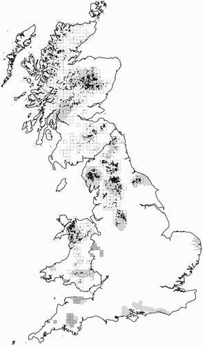
Within each stratum, tetrads were randomly selected for surveying by country. A higher sampling intensity was applied to Stratum 1 (Wotton et al. Citation2002), so that survey effort was distributed proportionately to density, with the objective of improving survey precision. Across the UK, 300 tetrads were selected from Stratum 1 and 250 tetrads were selected from Stratum 2 (). More tetrads were selected in both strata in 2012 compared to 1999, with the aim of producing more robust population estimates. The sampling intensity was higher in Wales compared to N England and Scotland to ensure that the sample size was large enough to enable a robust estimate to be calculated.
Table 1. A summary of the stratified sampling strategy during the 2012 survey, for N England, Scotland and Wales.
It should be noted here that the 2012 survey has highlighted that the survey area in Wales in 1999 was defined too narrowly. For coverage in Wales in 1999, it was considered that many of the formerly occupied tetrads would be unoccupied (Hurford Citation1996). Survey effort in Wales was therefore concentrated on a random sample of tetrads from those that were known to have been occupied within the period 1988–1998 (Wotton et al. Citation2002), with coverage also restricted due to a lack of resources to survey a larger number of tetrads in Wales. Thus in 1999, the survey in Wales only covered what was equivalent to Stratum 1 tetrads.
Outside of the sampled strata, all breeding records from Dartmoor, SW England, were obtained through an ongoing research project (Freshney et al. Citation2014), and historical sites in other areas, particularly in Shropshire and Northern Ireland, were checked.
Survey methods
The 2012 survey methods followed those devised for the 1999 national survey (Wotton et al. Citation2002). There were two visits to each survey tetrad, with the first visit between mid-April and mid-May and the second between mid-May and the end of June. As in 1999, playback was used to help elicit a response from any Ring Ouzels present as they can otherwise be a difficult species to detect, but the intention was to avoid luring birds from one area to another (e.g. from outside of the survey square). The same recording of song was used as in 1999, although MP3 players with a Radioshack mini amplifier/speaker were used in 2012, rather than the cassette players used in 1999; comparative tests at varying distances were undertaken to ensure that the MP3 players produced a similar sound level to the cassette players used in 1999. Although Ring Ouzels are likely to be most active in the early mornings and evenings, the use of playback ensured that surveying could continue throughout the day as many squares were located in remote upland areas. Surveying was avoided in persistent rain, in windy conditions (greater than Beaufort Scale 4 or 5) or in low cloud or foggy conditions when visibility may have been curtailed.
Ideally, each tetrad was covered by walking transects 500 m apart, running in either a north-south or east-west direction and perpendicular to any main linear features within the tetrad, for example, river valleys, to avoid following them. The start of the first transect was 250 m in from the edge of the tetrad, thus four transects were covered in each tetrad. The objective was to play Ring Ouzel song at points along the transect lines, to within 250 m of all parts of the tetrad: the first point of playback was 250 m along the first transect line, and then at roughly 500 m intervals along each of the transect lines. In practice, the actual route walked was frequently modified to avoid unsafe terrain, such as cliffs and steep scree slopes: in these cases, a route was taken that covered as much of the tetrad as possible, so that the playback points covered the tetrad to within 250 m of all points. Surveyors were made aware that in narrow, winding valleys there may be territories between the transect lines that could be difficult to locate. The locations of any Ring Ouzels seen or heard while walking the transect lines were recorded on a 1:10,000 map of the tetrad, using standard British Trust for Ornithology symbols to denote their behaviour and breeding status (Bibby et al. Citation2000). Any Ring Ouzel registrations were summarized on a survey form by using 2007–11 Bird Atlas breeding evidence codes (Balmer et al. Citation2013). Birds present in suitable nesting habitat but showing no signs of breeding behaviour were also recorded.
All suitable Ring Ouzel habitat within each tetrad was covered regardless of altitude; it was not necessary to survey tetrads containing no suitable habitat, although it should be noted that these tetrads were retained in the analyses as holding zero territories. The only terrestrial habitats that were excluded from the survey were dense forestry, farmland and built-up areas. It should be noted that T. t. alpestris may breed in dense forestry (Ciach & Mrowiec Citation2013), but T. t. torquatus has never been known to nest in this habitat in the UK or Fennoscandia. Access permission was obtained from landowners before entering privately owned land in England and Wales, and in Scotland landowners were informed of our intention to conduct the survey.
The ideal transect lines and playback points were pre-printed on each tetrad survey map. At each playback point, the recording was played for approximately 20 seconds, and then 5–10 minutes was spent listening and watching for any Ring Ouzel activity. At each playback point, observers were asked to find a position from which they had as clear a view as possible. Where there was a lot of Ring Ouzel activity in an area, it was suggested that it would be beneficial to stop for up to 20 minutes in order to attempt to determine the number of territories present.
Data analysis
Based on the recorded behaviour, the estimated minimum number of territories comprised the probable and confirmed breeding records in a tetrad, and the maximum estimate included possible breeding birds that were recorded in suitable breeding habitat but showed no signs of territorial behaviour, as well as possible additional territories that could not be assigned to confirmed or probable breeding.
Population estimates were calculated individually for Scotland, N England, Wales and the UK. In each case estimates were calculated for the two strata separately then combined, to allow for the different sampling intensity within each stratum. Confidence intervals (CIs) on the population estimates were obtained by using a bootstrapping procedure with 999 replicates, with the 2.5th and 97.5th percentiles from these replicates taken as the 95% confidence limits (CLs) (Efron & Tibshirani Citation1986, Greenwood Citation1991). Elsewhere, it was assumed that all territories were found. The UK estimate was produced by summing the constituent country and regional estimates, with CLs calculated by summing the randomly sorted bootstrap estimates for Scotland, N England and Wales, plus the total for SW England, with the 2.5th and 97.5th percentiles from the 999 combined estimates taken as the 95% CLs. To test for significance, a randomization test was used, following the same procedure used in Sim et al. (Citation2007)Footnote1. Population estimates were also calculated for the upland National Parks in England, Scotland and Wales, where a sufficient number of tetrads were surveyed, to assess the importance of the National Park network in Britain for breeding Ring Ouzels.
Estimation of survey efficiency
An attempt was made to calibrate the national survey methods, in order to estimate how efficient these methods were at detecting Ring Ouzel territories. This was done in three areas with long-running intensive Ring Ouzel studies where we are confident that all breeding pairs are located and monitored: Glen Clunie (Cairngorms National Park, Scotland), Rosedale (North York Moors National Park, England) and on Dartmoor National Park, England (Sim et al. Citation2011, Freshney et al. Citation2014, Hutchinson & Fairbrother Citation2014). Surveyors, who were not involved in the long-running studies, used the national survey methods to survey six tetrads that encompassed the Glen Clunie study area, three tetrads in Rosedale and six tetrads on Dartmoor. We then compared the numbers found by these surveyors with those determined by the intensive, multi-visit work being conducted by local Ring Ouzel researchers, in order to derive an estimate of the proportion of pairs missed by our methods. From the proportion of pairs missed, it was thus possible to revise the population estimates for England, Scotland, Wales and the UK. CLs on the revised estimates were obtained by re-running the bootstrapping procedure after the number of territories within each tetrad was divided by the proportion of pairs missed by the national survey methods.
Altitude analysis
The altitudes at the centre point of all territories recorded in 1999 and 2012 were extracted and the mean territory altitude was calculated for each country. To understand if any differences between years were a result of the stratified selection of survey squares in each year, mean altitudes of all the surveyed tetrads in 1999 and 2012 were calculated by creating 100 random points in each surveyed tetrad and extracting the altitude of each point (in ArcGIS 10.1) to produce a mean altitude per tetrad. For England, Scotland and Wales, z-tests were carried out to determine if there were any significant differences between the mean tetrad altitudes in 1999 and 2012, for all surveyed tetrads and for occupied tetrads only.
Response to playback
The reaction of any Ring Ouzels to the playback was recorded by noting whether birds responded to playback and if they were only located in response to playback, as well as the time taken to elicit a response and the type of response (song, agitated behaviour or no vocal reaction).
Results
Across N England, Scotland and Wales in 2012, 484 tetrads were surveyed (88% of the original sample; ). This compares favourably to the 1999 survey, when 284 tetrads were covered. A number of the selected tetrads were not surveyed for a number of reasons, particularly in Scotland (). Where possible, replacement squares were surveyed, selected in order from the original random sample by country. The numbers of Ring Ouzel territories recorded from the tetrad sample in N England, Scotland and Wales are summarized in , by stratum.
Table 2. A summary of the numbers of Ring Ouzels found during the 2012 survey, for N England, Scotland and Wales.
Population estimates
A minimum of 449 territories and maximum of 501 territories were recorded by the survey (). The main difference between the minimum and maximum population estimates was from individual birds either flying over the tetrad or showing no signs of territorial behaviour, although it is possible that the maximum figures also included pairs that were double-counted or where the bulk of the territory was in adjacent tetrads. It is reasonable to assume that the maximum estimate allows for the difficulties in surveying an upland species such as Ring Ouzel, and is thus a more accurate reflection of the actual population.
The UK population in 2012 is estimated at a minimum of 4659 (95% CI, 3508–6060) territories and a maximum of 5332 (95% CI, 4096–6875) territories. The population estimates for England, Scotland and Wales are shown in . In SW England, 11 territories were located on Dartmoor as part of the intensive study of the breeding population here (Nick Baker pers. comm.). No breeding territories were located elsewhere in the UK, including from Northern Ireland (Kendrew Colhoun pers. comm.) or from Shropshire (Leo Smith pers. comm.).
Table 3. Ring Ouzel population estimates in 2012, by country and for the UK, and a comparison with the results from the first national UK survey in 1999. The 95% CLs are shown in parentheses for each estimate. The minimum estimates comprise the probable and confirmed breeding records, and the maximum estimates included possible breeding birds, which may have been recorded in suitable breeding habitat but showed no signs of territorial behaviour, or were possible additional territories that could not be assigned to confirmed or probable breeding.
Overall, the maximum estimate for 2012 was 29% lower than in 1999, but this difference was not statistically significant (). In Scotland and England, there was a non-significant decline of 36% and 23%, respectively, between 1999 and 2012. In Wales, there was a non-significant increase of 39% between 1999 and 2012 (), although it is more likely that the 1999 survey estimate was too low due to the survey area being defined incorrectly, as discussed in the Methods. For a direct comparison between the two surveys, the 2012 Stratum 1 estimate should be compared with the 1999 estimate: in 2012, there were 349 (95% CL, 244–470) territories estimated in Stratum 1, suggesting a non-significant 11% decline between the two survey periods.
Thirty-six tetrads were surveyed in both 1999 and 2012 (9 in North England, 15 in Scotland and 12 in Wales), and a comparison of the results from these tetrads indicates a significant 33% decline between the two surveys: 78 territories were recorded in 1999 and 51 territories in 2012 (T = 30.5, P < 0.002, Wilcoxons test for matched pairs). Looking further back, 79 of the tetrads surveyed in 2012 were also occupied during the 1988/91 Atlas fieldwork. In 2012, 23 of these tetrads (29%) were unoccupied and the mean number of territories recorded across the 79 tetrads was significantly lower in 2012 (1.63) than in 1988–91 (2.09) (z = 1.96, P = 0.05), although the data are not directly comparable as the 2012 survey effort was specifically designed to locate Ring Ouzels and more intensive than that for the 1988–91 Atlas.
It was possible to produce 2012 population estimates for all but one of the upland National Parks in Britain (); too few tetrads were surveyed in Loch Lomond and the Trossachs to be able to produce an estimate. The network of National Parks in Britain held around a third of the UK Ring Ouzel population in 2012, highlighting their importance for this species, particularly in Wales where Snowdonia National Park held 72% of the Welsh population ().
Table 4. Ring Ouzel maximum population estimates for the National Parks in England, Scotland and Wales in 2012, where there was sufficient coverage. It was not possible to produce estimates for Loch Lomond and the Trossachs due to the small number of tetrads surveyed.
Table 5. A summary of the Ring Ouzel contacts responding to playback during each visit. The number, and proportion, of territories only found by playback is also summarized.
Estimation of survey efficiency
It was not possible to conduct a meaningful examination of survey efficiency from the Dartmoor tetrads, as the six tetrads surveyed using national survey methods held only four territories and were not all surveyed twice during the survey period. In the Glen Clunie study area, there were known to be 26 territories, of which 22 (85%) were recorded using the national survey methods. In Rosedale, 10 of the 12 known territories (83%) were found through the national survey methods. Overall, coverage following the national survey methods recorded 32 of the 38 known territories in these two study areas (84%), and it should be noted that no additional territories were found through the national survey methods. These results suggest that a corrected maximum estimate for Britain in 2012 was 6348 (95% CL, 4825–8198) territories. For England, Scotland and Wales, the corrected maximum estimates were 1506 (95% CL, 1073–2018), 4190 (95% CL, 2785–5975) and 651 (95% CL, 402–953) territories, respectively.
Altitude analysis
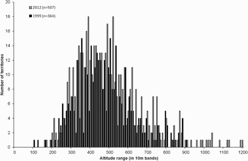
The mean altitude of the 501 territories located during the 2012 survey was 501 m (±7.8 se) asl, with the altitude range between 160 m (in Northumberland), and 1200 m (in the Cairngorms), compared to a mean altitude of 473 m (±7.9 se) from 359 territories in 1999 (range, 100–900 m) ().
Figure 2. The altitude range of the Ring Ouzel territories found during the 1999 and 2012 surveys, in ten bands. The recorded altitude (metres asl) is from the centre point of each territory.
In 2012, the mean altitude of the occupied tetrads in England was 490 m (±11.3 se) compared to 432 m (±18.3 se) in 1999, a significant increase between the two surveys (z = 1.96, P = 0.05), despite there being no significant difference in the mean altitudes of the surveyed tetrads in both years (z = 0.61, P = 0.54). In Scotland the mean altitude of the occupied tetrads was 550 m (±16.6 se) in 2012 and 440 m (±22.0 se) in 1999, a significant increase between the two surveys (z = 3.99, P < 0.001), although this difference appears to be mainly an artefact of the stratified random sampling in each survey year, rather than a real change in altitudinal distribution, as the mean altitude of the surveyed tetrads in 1999 was significantly lower than in 2012 (z = 4.36, P < 0.001). In Wales there was little difference between the two survey years: the mean altitude of occupied tetrads was 405 m (±22.1 se) in 2012 and 437 m (±19.9 se) in 1999 (z = 1.08, P = 0.28), and there was little difference in the mean altitudes of the surveyed tetrads (z = 1.36, P = 0.18).
From a comparison of the territories recorded in the 36 tetrads covered in both survey years, there was no significant change in mean territory altitudes between 1999 (464.4 m, ±14.4 se) and 2012 459.6 m, ±16.1 se) (z = 0.22, P = 0.83).
Playback
A playback response was reported from 50% of the recorded territories in 2012 (74% in 1999); 27% of territories were located only through playback (32% in 1999). There were notable differences in response rates between countries, with Ring Ouzels in Wales most likely to respond to playback (). There was significant variation in the probability of a Ring Ouzel responding to playback in Scotland, N England or Wales (Χ2 = 18.992, df = 1, P = 0.004), with a lower probability of response in Scotland compared to N England and Wales. In 1999, the probability of response was lower in N England compared to Scotland or Wales. There was variation in response between months (Χ2 = 4.96, df = 2, P = 0.026), with the response probability being higher in May than in April or June, compared to 1999 when the response probability was higher in May and June than in April (Wotton et al. Citation2002). There was no correlation between increasing response time and increasing distance of the contact from the playback point.
The majority of responses to playback were from up to 100 m from the playback point (n = 142, 56%), with 87% of the responses within 250 m of the playback point (n = 217, 85% in 1999), suggesting that the MP3 players employed in 2012 were as effective as the 1999 cassette players. Of the Ring Ouzels responding to playback, 54% did so within 60 seconds of playback, a much lower proportion than in 1999 (68%).
Discussion
The results from the 2012 survey suggest a substantial population decline across the UK, and within England, Scotland and Wales, since the first UK-wide survey in 1999 and reinforce the conservation concern for this species (Eaton et al. Citation2015). The survey results are consistent with the decline in the range and relative abundance shown in the 2007–11 Atlas (Balmer et al. Citation2013). The reported declines between the two surveys were not significant, as the wide CLs around the 1999 population estimates limit our ability to detect significant change. That said, the significant decline in the number of territories from the 36 tetrads surveyed in both years suggests that a real population decline is taking place. This is backed up by looking at the change in the geographical range of Ring Ouzels over the three Breeding Bird Atlases (Sharrock Citation1976, Gibbons et al. Citation1993, Balmer et al. Citation2013), with the number of occupied 10-km squares in Britain declining by 27% between the 1968–72 and 1988–91 Atlases, and by 22% between the 1988–91 and 2007–11 Atlases.
The Stratum 1 sample consisted of tetrads known to have been occupied between 1999 and 2011, but 30% of the tetrads surveyed in Scotland, 40% in England and 39% in Wales held no Ring Ouzels in 2012, which might suggest that there has been range loss within areas known to have been occupied relatively recently. There is some evidence to suggest, however, that a comparison between two surveys several years apart does not take account of any potential inter-annual population shifts, which has been documented by Burfield (Citation2002) and Smith (Citation2014).
Regional population changes
The majority of the UK population of Ring Ouzels remains in Scotland (). The decline suggested by the 2012 survey results is much less than the regional declines reported in Sim et al. (Citation2010) from intensive studies carried out by members of the Ring Ouzel Study Group, including declines of 70% in part of the NW Highlands between 1999 and 2007, 83% in Glen Callater, NE Scotland, between 1998 and 2007, and declines of around 50% in the Lammermuirs, Moorfoots and Pentlands in SE Scotland between 1985 and 2006. There have, however, been more recent signs of stability or even a recovery in some of the regularly monitored areas. In Glen Clunie, where Ring Ouzels have been monitored annually since 1998, numbers declined from 39 pairs in 1998 to 13 in 2009, since when the population has started to recover again, with 35 pairs recorded in 2015 (Graham Rebecca & Innes Sim pers. comm.). In Glen Effock, east of Glen Clunie, the number of Ring Ouzel territories increased by 124% between 2002 (n = 25) and 2010 (n = 56) (http://www.ringouzel.info/localstudies.html). The 2007–11 Atlas highlighted further range declines in Scotland since 1988–91, particularly in the northeast and southwest of the country (Balmer et al. Citation2013).
The 2012 survey results suggest that the population also declined in England between 1999 and 2012, although this was not significant. Local studies appear to show a mixed picture. Declines were reported from regular monitoring of study areas in the Forest of Bowland and the North Yorkshire Moors until 2007 and 2004, respectively, but were then followed by stable or even increasing numbers (Sim et al. Citation2010). In 2012, numbers in the North Yorkshire study area were at their highest since 2000 (Hutchinson & Fairbrother Citation2014). Conversely, study areas in the south of England have shown decline and loss with no sign of recovery. On Dartmoor, there were an estimated 35–45 pairs during 1977–85 (Sitters Citation1988) and the 1990s (Jones Citation1996) but there has subsequently been a decline, with only 11 pairs in 2012. An intensive nest monitoring study started in 2010 to attempt to understand these declines (Freshney et al. Citation2014). It is probable that Ring Ouzels no longer breed on Exmoor, with the last confirmed breeding record in 2002 (Sim et al. Citation2010), or in Shropshire, with breeding last confirmed on the Long Mynd in 2003 (Smith Citation2006). Although the 2007–11 Atlas shows a further range decline in England, this was less pronounced than between the first two breeding bird atlas periods (Balmer et al. Citation2013).
The Welsh population was estimated at a maximum of 600 pairs in 1972 (Lovegrove et al. Citation1994), with reported declines to 430–530 in the late 1980s (Tyler & Green Citation1994) and 290–390 in the 1999 survey (). The 2012 survey estimate of 547 (333–798) pairs suggests that there has either been a large population increase in recent years, or it is more likely that the 1999 survey estimate was too low due to the survey area being defined incorrectly. Recent survey work in Snowdonia (2009–10) has suggested that numbers there are stable or possibly increasing over a 20-year period (Driver Citation2011), although an earlier survey of 26 of the 35 Welsh tetrads from the 1999 national survey, in 2006, showed a decline of 69% (Green Citation2007). A more detailed study of historical territories in the Rhinog Mountains, between 2009 and 2011, suggested there had been a 50% decline over 40 years, although 67% of the historical territories were occupied in one or more of the years 2009–11 (Smith Citation2014). The 2007–11 Atlas showed a continuing range decline in south and mid Wales (Balmer et al. Citation2013), with birds confined to the Brecon Beacons National Park in south Wales and very few records in mid Wales.
Effectiveness of the survey methods and the use of playback
The results from the estimation of survey efficiency suggest that the national survey methods are an effective way of recording a species that is elusive, shy and lives in remote areas that are difficult to survey. Although this calibration only covered two, albeit very different, study sites, a similar proportion of territories were recorded by the national survey methods in both areas. It has allowed us, for the first time, to produce an estimate of the actual number of Ring Ouzels in the UK with detection efficiency accounted for, on the assumption that the intensive surveys in Glen Clunie and Rosedale located all of the territories in the respective study areas.
The survey methods ensured that the tetrads were surveyed systematically. Playback should be considered an integral part of Ring Ouzel survey methods in the UK given the proportion of territories only found by playback in both national surveys so far: 32% and 27% of territories were recorded only as a result of playback in 1999 and 2012, respectively. Overall, the response to playback was lower in 2012 than in 1999, at least in north England and Scotland, for reasons that are not clear.
Further monitoring and research
Analysis of the 1999 and 2012 survey data provides no evidence that Ring Ouzel territories have shifted to higher altitudes between the two survey periods, although there is some evidence that climate change is already having an impact on populations. Beale et al. (Citation2006) suggested that increasing summer temperatures may be the cause of declines in the Ring Ouzel population in Britain. In Switzerland, for example, a climate-induced decrease in suitable habitat is predicted to shift the range by up to 440 m higher by 2070 (von dem Bussche et al. Citation2008), although the population has stabilized here since 2000 (BirdLife International Citation2015). Huntley et al. (Citation2007) predicted that the distribution of Ring Ouzel will shift northwards as a consequence of climate change, which would make much of the south of the present range no longer suitable.
There is some evidence from recent research in the UK that declines in breeding populations are caused by low first-year survival, with re-nesting rate and early-season productivity also factors (Sim et al. Citation2011). A mix of habitat mosaics are required during and after the breeding season that provide abundant invertebrate and berry food, dense vegetation for nesting and concealment from predators (Sim et al. Citation2013). A trial habitat management project is now underway at sites in North England that aims to manipulate habitat composition and structure, to encourage Ring Ouzels to return former breeding areas, and to increase breeding numbers through improved productivity or first-year survival. Any effects from the increasing frequency of moorland burning (Douglas et al. Citation2015) and increasing upland recreational disturbance (Bathe Citation2007) may also be worth further study.
More research needs to be undertaken to understand the potential threats on migration, including indirect hunting pressure (Burfield Citation2001), and on the wintering grounds, including loss or degradation of juniper scrub (Ryall & Briggs Citation2006). In the UK, continued monitoring of study areas is important, along with regular national surveys, to help to detect and understand any future changes in the UK population.
Acknowledgements
The 2012 Ring Ouzel survey was organized by RSPB under the Statutory Conservation Agencies/RSPB Annual Breeding Birds Scheme (SCARABBS) and jointly funded by RSPB, Natural England, Natural Resources Wales, Scottish Natural Heritage and Snowdonia National Park. Thanks are due to the many people who took part in the survey and to all the landowners and site managers who allowed access. Jeff Burgum, Ronan Dugan, James Gordon, Jayne Kelly, Ian McNee, Tony Rogers and John Tayton undertook much of the fieldwork as RSPB research assistants. Particular thanks go to Chris Rollie and the Ring Ouzel Study Group, Innes Sim, Vic Fairbrother, Ken Hutchison, Nick Baker, Ian Court, Kendrew Colhoun, Leo Smith, Bill Gordon, Graeme Pyatt, John Strowger, James Anderson, Chris Tyas, Gethin Davies and Dave Smith. Additional thanks go to Graham Rebecca and Innes Sim for providing Glen Clunie data and Vic Fairbrother and Ken Hutchison the Rosedale data, for the national survey calibration. Ring Ouzel data from Bird Atlas 2007–11, which is a joint project between BTO, BirdWatch Ireland and the Scottish Ornithologists’ Club, were provided by Simon Gillings.
Notes
1. The observed difference between the population estimates from each year is referred to as D. Using the unsorted bootstrapped population estimates from 1999 and 2012, 999 estimates of the difference in the population between the two surveys were made, by subtracting each unsorted bootstrapped estimate for 1999 from the corresponding estimate for 2012. These differences are referred to as d1 … d999. Each of these differences was subtracted from D to give d*1 … d*999. The proportion of d* values with an absolute value greater than D was used as an estimate of the chance occurrence of the observed difference, D.
References
- Arthur, D.S.C., Ellis, P.R., Lawie, R.G. & Nicoll, M. 2000. Observations of wintering Ring Ouzels and their habitat in the High Atlas Mountains, Morocco. Scott. Birds 21: 109–115.
- Ayé, R., Keller, V., Müller, W., Spaar, R. & Zbinden, N. 2011. Révision 2010 de la Liste Rouge et des Espèces Prioritaires de Suisse. Nos Oiseaux 58: 67–84.
- Balmer, D.E., Gillings, S., Caffrey, B.J., Swann, R.L., Downie, I.S. & Fuller, R.J. 2013. Bird Atlas 2007–11: The Breeding and Wintering Birds of Britain and Ireland. BTO Books, Thetford.
- Bathe, G. 2007. Political and social drivers for access to the countryside: the need for research on birds and recreational disturbance. Ibis 149: 3–8. doi: 10.1111/j.1474-919X.2007.00639.x
- Baxter, E.V. & Rintoul, L.J. 1953. The Birds of Scotland. Oliver and Boyd, Edinburgh.
- Beale, C.M., Burfield, I.J., Sim, I.M.W., Rebecca, G.W., Pearce-Higgins, J.W. & Grant, M.C. 2006. Climate change may account for the decline in British Ring Ouzels Turdus torquatus. J. Anim. Ecol. 75: 826–835. doi: 10.1111/j.1365-2656.2006.01102.x
- Bibby, C.J., Burgess, N.D. & Hill, D.A. 2000. Bird Census Techniques. 2nd edn. Academic Press, London.
- BirdLife International. 2015. European Red List of Birds. Office for Official Publications of the European Communities, Luxembourg.
- Burfield, I.J. 2001. Ringed Ouzels: where do they go in winter? Ringers’ Bull. 10: 58.
- Burfield, I.J. 2002. The breeding ecology and conservation of the Ring Ouzel Turdus torquatus in Britain. PhD Thesis, Cambridge University.
- von dem Bussche, J., Spaar, R., Schmid, H. & Schroder, B. 2008. Modelling the recent and future spatial distribution of the Ring Ouzel (Turdus torquatus) and Blackbird (T. merula) in Switzerland. J. Ornithol. 149: 529–544. doi: 10.1007/s10336-008-0295-9
- Ciach, M. & Mrowiec, W. 2013. Habitat selection of the Ring Ouzel Turdus torquatus in the Western Carpathians: the role of the landscape mosaic. Bird Study 60: 22–34. doi: 10.1080/00063657.2012.745463
- Cramp, S. (ed) 1988. The Birds of the Western Palearctic, Vol. 5. OUP, Oxford.
- Del Hoyo, J., Elliott, A. & Christie, D.A. (eds) 2005. Handbook of the Birds of the World, Vol. 10: Cuckoo-shrikes to Thrushes. Lynx Edicions, Barcelona.
- Douglas, D.J.T., Buchanan, G.M., Thompson, P., Amar, A., Fiedling, D.A., Redpath, S.M. & Wilson, J.D. 2015. Vegetation burning for game management in the UK uplands is increasing and overlaps spatially with soil carbon and protected areas. Biol. Cons. 191: 243–250. doi: 10.1016/j.biocon.2015.06.014
- Driver, J. 2011. Population census of Ring Ouzels Turdus torquatus breeding in Snowdonia, 2009–10. Birds Wales 8: 3–13.
- Eaton, M.A., Aebischer, N.J., Brown, A.F., Hearn, R.D., Lock, L., Musgrove, A.J., Noble, D.G., Stroud, D.A., Evans, A. & Gregory, R.D. 2015. Birds of Conservation Concern 4: the population status of birds in the UK, Channel Islands and Isle of Man. Br. Birds 108: 708–746.
- Efron, B. & Tibshirani, R. 1986. Bootstrap methods for standard errors, confidence intervals, and other measures of statistical accuracy. Stat. Sci. 1: 54–75. doi: 10.1214/ss/1177013815
- Flegg, J.J.M. & Glue, D.E. 1975. The nesting of the Ring Ouzel. Bird Study 22: 1–8. doi: 10.1080/00063657509476434
- Freshney, F., Baker, N. & Booker, H. 2014. A future for Dartmoor’s Ring Ouzels?. Devon Birds 67: 17–24.
- Gibbons, D.W., Reid, J.B. & Chapman, R.A. 1993. The New Atlas of Breeding Birds in Britain and Ireland: 1988–1991. Poyser, London.
- Gibbons, D.W., Avery, M.A. & Brown, A.F. 1996. Population trends of breeding birds in the United Kingdom since 1800. Br. Birds 89: 291–305.
- Green, M. 2007. Wales Ring Ouzel Turdus torquatus survey in 2006. Welsh Birds 5: 37–41.
- Greenwood, J.J.D. 1991. Estimating the total number and its confidence limits. Appendix to: Shrubb, M. & Lack, P.C. The numbers and distribution of Lapwings V. vanellus nesting in England and Wales in1987. Bird Study 38: 20–37. doi: 10.1080/00063659109477063
- Hagemeijer, W.J.M. & Blair, M.J. 1997. The EBCC Atlas of European Birds: Their Distribution and Abundance. Poyser, London.
- Holloway, S. 1996. The Historical Atlas of Breeding Birds in Britain and Ireland 1875–1900. T. & A.D. Poyser, London.
- Huntley, B., Green, R.E., Collingham, Y.C. & Willis, S.G. 2007. A Climatic Atlas of European Breeding Birds. Lynx Edicions, Barcelona.
- Hurford, C. 1996. The decline of the Ring Ouzel Turdus torquatus breeding population in Glamorgan. Welsh Birds 1(3): 45–51.
- Hutchinson, K. & Fairbrother, V. 2014. Findings of a study of Ring Ouzel Turdus Torquatus territories in Rosedale and other areas of the North York Moors: Ring Ouzel report 2012. Unpublished report.
- Jones, R. 1996. A study of Ring Ouzels breeding on Dartmoor. Devon Birds 49: 54–60.
- Lovegrove, R., Williams, G. & Williams, I. 1994. Birds in Wales. Poyser, London.
- Ryall, C., & Briggs, K. 2006. Some factors affecting foraging and habitat of Ring Ouzels Turdus torquatus wintering in the Atlas Mountains of Morocco. Bull. African Bird Club 13: 17–31.
- Sharrock, J.T.R. 1976. The Atlas of Breeding Birds in Britain and Ireland. Poyser, Calton.
- Sim, I.M.W., Dillon, I.A., Eaton, M.A., Etheridge, B., Lindley, P., Riley, H., Saunders, R., Sharpe, C. & Tickner, M. 2007. Status of the Hen Harrier Circus cyaneus in the UK and Isle of man in 2004, and a comparison with the 1988/89 and 1998 surveys. Bird Study 54: 256–267. doi: 10.1080/00063650709461482
- Sim, I.M.W., Rollie, C., Arthur, D., Benn, S., Booker, H., Fairbrother, V., Green, M., Hutchinson, K., Ludwig, S., Nicoll, M., Poxton, I., Rebecca, G., Smith, L., Stanbury, A. & Wilson, P. 2010. The decline of the Ring Ouzel in Britain. Br. Birds 103: 229–239.
- Sim, I.M.W., Rebecca, G.W., Ludwig, S.C., Grant, M.C. & Reid, J.M. 2011. Characterising demographic variation and contributions to population growth rate in a declining population. J. Anim. Ecol. 80: 159–170. doi: 10.1111/j.1365-2656.2010.01750.x
- Sim, I.M.W., Ludwig, S.C., Grant, M.C., Loughrey, J.L., Rebecca, G.W. & Reid, J.M. 2013. Post-fledging survival, movements and dispersal of Ring Ouzels. The Auk 130: 69–77. doi: 10.1525/auk.2012.12008
- Sitters, H.P. 1988. Tetrad Atlas of the Breeding Birds of Devon. DBWPS, Yelverton.
- Smith, L. 2006. Shropshire Biodiversity Action Plan for Ring Ouzel. Shropshire Biodiversity Partnership, Shrewsbury.
- Smith, D. 2014. The Ring Ouzel Turdus torquatus on the Rhinog Mountains: a 40 year perspective. Birds Wales 11(2): 22–31.
- Thom, V.M. 1986. Birds in Scotland. Poyser, Calton.
- Tucker, G.M. & Heath, M.F. 1994. Birds in Europe: Their Conservation Status. BirdLife International, Cambridge.
- Tyler, S.J. & Green, M. 1994. The status and breeding ecology of Ring Ouzels Turdus torquatus in Wales with reference to soil acidity. Welsh Bird Rep. 7: 78–89.
- Wernham, C., Toms, M., Marchant, J., Clark, J., Siriwardena, G. & Baillie, S. 2002. The Migration Atlas: Movements of the Birds of Britain and Ireland. Poyser, London.
- Williamson, K. 1975. Birds and climatic change. Bird Study 22: 143–164. doi: 10.1080/00063657509476459
- Wotton, S.R., Langston, R.H.W. & Gregory, R.D. 2002. The breeding status of the Ring Ouzel Turdus torquatus in the UK in 1999. Bird Study 49: 26–34. doi: 10.1080/00063650209461241