
 ?Mathematical formulae have been encoded as MathML and are displayed in this HTML version using MathJax in order to improve their display. Uncheck the box to turn MathJax off. This feature requires Javascript. Click on a formula to zoom.
ABSTRACT
Capsule: Breeding bird survey data were used to compare biodiversity at sites defined as High Nature Value farmland (HNVf) under two different mapping models.
Aims: To examine whether farmland classified as HNVf was important for bird diversity and conservation of priority bird species in Cyprus, through comparison of two different HNVf maps. The HNV concept aims to define biodiversity-rich farmland and facilitate its protection and management. Heterogeneous, low-intensity cropping and grazing systems are important areas for biodiversity conservation in Europe and for birds in particular, but are threatened by abandonment and agricultural intensification. We compared two HNVf mapping systems, a simpler model based on land cover data (CLC map) and a more complex Cyprus Environment Department model (ED map) including layers relating to agricultural intensity.
Methods: Line transect bird surveys were carried out to compare bird diversity, abundance of farmland bird species of conservation priority and also of the endemic Cyprus Warbler Sylvia melanothorax, at sites classified as HNV or not.
Results: A greater diversity of breeding birds was found in sites classified as HNVf under combined ED and CLC maps. However, for the set of 12 priority bird species, neither HNV mapping approach encompassed their overall abundance, but a combined CLC and ED model did predict higher abundances of the Cyprus Warbler. Vineyard sites were found to be associated with high overall breeding bird diversity, but with low abundance of priority bird species.
Conclusion: We identified weaknesses in both mapping systems, with the ED model failing to capture all HNV grazing land and the CLC model defining some intensive farming systems as HNV. We conclude that the overlap between the two models best captures HNVf, but layers encompassing grazing land and priority habitats need to be added to better define HNVf in Cyprus and facilitate its protection and management.
Introduction
Farming is the dominant land use in Europe and in the Mediterranean basin in particular, where agriculture has had a significant influence on ecosystems for millennia (Blondel & Aronson Citation1999, Grove & Rackham Citation2001, Allen Citation2001, Arga & Ne’eman Citation2009, Stoate et al. Citation2009, Oppermann et al. Citation2012). Low-intensity farming systems – often associated with traditional practices and more marginal land – create important habitats for wildlife in Europe and biodiversity conservation is, to a large degree, dependent on the continuation of such systems (Tucker & Heath Citation1994, Tucker & Evans Citation1997, Beaufoy et al. Citation1994, Bignal & McCracken Citation1996, Citation2000, Donald et al. Citation2002, BirdLife International Citation2004, Stoate et al. Citation2009, Oppermann et al. Citation2012, Lomba et al. Citation2015). Abandonment of active farming in low intensity systems or conversion to more intensive agriculture have both been identified as major threats to many species of conservation concern and notably bird species that are open-country specialists, mainly because abandonment and intensification lead to shifts to less heterogeneous habitats (Tucker & Heath Citation1994, Tucker & Evans Citation1997, Benton et al. Citation2003, Green et al. Citation2005, Suarez-Seoane et al. Citation2002, Donald et al. Citation2002, Citation2006, Sirami et al. Citation2008, Stoate et al. Citation2009, Doxa et al. Citation2010). This loss of heterogeneity can occur – and has an impact on biodiversity – at both farm and landscape scales, through crop specialization and loss of landscape features such as hedgerows and fallow land (Benton et al. Citation2003). Most relevant work has been done in Western Europe and may not always be applicable to Central and Eastern Europe, where homogenous landscapes can be positively associated with density of grassland specialist birds (Baldi & Batary Citation2011). In Cyprus, heterogeneous farmland has been shown to be of more value for birds than more natural habitats such as forest and scrub (Ieronymidou Citation2012). Sampling birds and land-use at 202 localities across Cyprus, Ieronymidou (Citation2012) related abundance and richness within bird categories to habitat and land-use. A wide range of habitat and land-use elements were found to be important and cultivated habitats were particularly valuable (especially groves and vines), being positively associated with more bird assemblages than semi-natural habitats. The presence of remnants of natural vegetation within cultivation was shown to be positively associated with bird diversity.
The High Nature Value farmland (HNVf) concept was first developed by Baldock et al. (Citation1993) and Beaufoy et al. (Citation1994) to define farmland types and practices that support high levels of biodiversity. The aim was to inform and promote efforts at the European Union (EU) level to halt biodiversity decline and promote sustainable farming. Andersen et al. (Citation2003) defined HNVf as:
Those areas in Europe where agriculture is a major (usually the dominant) land use and where that agriculture supports, or is associated with, either a high species and habitat diversity or the presence of species of European conservation concern, or both.
Paracchini et al. (Citation2008) further developed the HNVf concept, identifying three broad types:
Type I – Farmland with a high proportion of semi-natural vegetation.
Type II – Farmland with a mosaic of low-intensity agriculture with natural and structural elements, such as field margins, hedgerows, dry stone walls, patches of woodland or scrub, etc.
Type III – Farmland supporting rare species or a high proportion of European or global populations of one or more species.
Overlap exists between the three HNV types (Paracchini et al. Citation2008, Oppermann et al. Citation2012), but the broad classification is nonetheless a useful way of defining HNV farming systems. Type I HNV farmland comprises mostly grazing systems and meadows and this HNV farmland hosts not only priority species but also habitats of priority conservation concern listed in Annex I of the EU Habitats Directive (92/43/EEC) (Paracchini et al. Citation2008). Such systems require extensive agriculture for their maintenance (Paracchini et al. Citation2008). Type III HNV farming is the only type that can include intensively cropped areas, where such systems support priority species.
The EU Common Agricultural Policy (CAP) has had a negative impact on Europe’s farmland biodiversity in general and HNVf areas in particular, through subsidy systems that have encouraged abandonment in more marginal areas and intensification in more productive areas (Donald et al. Citation2002, Citation2006, Stoate et al. Citation2009, Voříšek et al. Citation2010). Efforts to reverse this impact have included the decoupling of CAP subsidies from production, the introduction of agri-environment measures and ‘greening’ reform, though this has been of questionable effectiveness (Pe’er et al. Citation2014). CAP subsidies can be effective for biodiversity conservation at a local or regional scale, through targeted schemes such as agri-environment-climate, but this does not scale up to effectiveness at an EU-wide scale (Pe’er et al. Citation2017). ‘Greening’ reform measures are generally not substantial enough to benefit biodiversity, though the implementation of the CAP system is sufficiently flexible at member state level to permit design of effective plans for protection of farmland biodiversity at the national level, where the political will exists (Pe’er et al. Citation2014).
The majority of the research on farmland biodiversity has focused on birds, which are easier to survey than many other taxa and are considered good barometers of environmental change (Robinson & Sutherland Citation2002, Donald et al. Citation2002). We also focused our Cyprus study on birds, though we acknowledge that HNV farmland is important also for other components of biodiversity (mammals, invertebrates and plants – Oppermann et al. Citation2012) and further research into these components would be of great value.
HNVf in Cyprus is under threat, as it is across Europe. Agricultural intensification usually linked to expansion of irrigation schemes, and abandonment in upland and marginal areas have been features of the farming landscape in Cyprus over the past 30–40 years, as shown by Cyprus government agricultural statistics for the period 1975–2012 (USAID Citation2006, Ieronymidou Citation2012, Eurostat Citation2017, Zomeni et al. Citation2018). Building development is an additional threat to HNVf areas in Cyprus (USAID Citation2006, Ieronymidou Citation2012).
The reliable mapping of HNVf provides a tool that can be key for the conservation of farmland biodiversity. It has policy relevance because HNVf is an environmental indicator for the Rural Development Regulation (RDR) of the CAP (Andersen et al. Citation2003, Paracchini et al. Citation2008). This translates into obligations for EU member states to assess whether HNVf systems are being maintained and managed.
The distribution of HNVf in Europe was estimated in a preliminary mapping exercise by the European Commission Joint Research Centre (JRC) and the European Environment Agency (EEA), (Paracchini et al. Citation2008). This analysis was based on the Coordination of information on the environment (CORINE) programme land cover data (see https://www.eea.europa.eu/publications/COR0-landcover) and on the extent of farmland designated within the EU NATURA 2000 network of areas protected under the EU Habitats Directive (92/43/EEC) and included within Important Bird Areas (IBAs) identified on the basis of recognized BirdLife International criteria (http://datazone.birdlife.org/site/ibacriteria). This mapping exercise identified around 30% of farmland in the EU as likely HNV and 54% of Cyprus farmland as HNV (342,045 ha of 637,043 ha). However, the resolution and accuracy of CORINE land cover (CLC) data has led to its reliability for modelling habitats to be questioned (Ieronymidou Citation2012).
Our aim in the current study was to examine whether farmland classified as HNV held significantly greater avian diversity in general and greater abundances of species of conservation priority in particular, with a focus on the endemic Cyprus Warbler Sylvia melanothorax. We looked at these questions and undertook an assessment using two approaches to mapping HNVf in Cyprus, which also allowed us to compare these two mapping approaches. One model was based only on CLC data and IBA coverage, the other on a series of parameters, mostly related to agricultural practice and land use, but including CLC, IBA and Natura 2000 data (Zomeni et al. Citation2018). We collected field data on breeding birds to test the classification of HNVf under the two mapping models, based on the hypothesis that HNVf would have greater diversity of species and greater abundance of species of conservation concern, compared to non-HNVf. We also aimed to determine if any bird species could be used as reliable indicators for HNVf in Cyprus, as has been found for other parts of Europe (Morelli et al. Citation2014, Morelli & Tryjanowski Citation2017). We focused on arable and perennial cropping systems (potential Type II and Type III HNVf) and not on the likely Type I HNVf that is the extensive areas of semi-natural scrub grazed by sheep and goats in Cyprus, as this is the focus for a separate study. While our study focused on Cyprus, the HNVf mapping approaches we looked at are easily replicable elsewhere in Europe, and in particular around the Mediterranean where habitats may be similar to those in Cyprus.
Methods
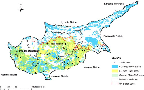
The study area covered the main farming areas of Cyprus south of the UN buffer zone. We focused on three of the dominant cultivation types in Cyprus: arable (predominantly barley), olives and vines (EU Farm structure survey, Citation2010). Using the 2012 CORINE database for Cyprus (MARDE Citation2016), we identified arable, olive grove and vineyard areas in all administrative districts (to ensure a broad geographical coverage). We then explored these study areas to identify accessible study sites with tracks or paths for survey work. The selection of 47 sites (25 arable, 11 olive grove and 11 vineyard sites) was balanced between sites classified as ‘likely HNV’ and ‘likely non-HNV’ based on CLC class, following Paracchini et al. (Citation2008). This approach ensured we covered both more intensive cultivation, including irrigated crops, and low-intensity cultivation, including areas with farmland mosaics (typical Type II HNVf). Site elevation ranged from 8 m to 995 m above sea level (mean = 300 m), except for one olive grove site at 1230 m above sea level. Sites were at least 500 m apart, while most were over 2000m apart ().
Figure 1. Map of Cyprus showing the location of the 47 study sites and the areas identified as High Nature Value farmland (HNVf) under the CORINE land cover-based map (‘CLC map’) and the Cyprus Environment Department map (‘ED map’), as well as the overlap between these two maps (‘Overlap ED & CLC maps’).
Bird surveys were carried out at each of the 47 study sites (one transect per site) following a line transect survey method (Bibby et al. Citation2000). Routes were walked at a slow pace while recording all birds seen or heard in four distance intervals: 0–10 m, 10–25 m, 25–50 m and 50–100 m from the transect line (distances were checked using a Bushnell Medalist laser range-finder). Transects mostly followed dirt tracks and averaged just under 1000 m in length, but varied from 500 to 1600 m. Sites were surveyed twice during the breeding period. Early season visits were from mid-March to end of April, to cover the peak period of song and display (and therefore peak detectability) of species such as the resident Sylvia warblers, while late season visits were in May and June, a better period for detecting late-arriving migrant breeders such as European Roller Coracias garrulus and Black-headed Bunting Emberiza melanocephala. Early and late visits to any given site always took place at least two weeks apart. Surveys were completed in the four hours after sunrise and were done on days with wind-free and rain-free conditions. The recorder never walked directly towards the sun. Especially in the more densely vegetated olive and vine sites, most observations were at first based on vocalizations, usually followed by visual confirmation. With the exception of aerial feeders such as hirundines, records of overflying birds were not included for analysis purposes.
We tested two different models for mapping HNVf areas in Cyprus ():
A CORINE Land Cover-based HNVf map (hereafter ‘CLC map’) including IBA data. This mapping exercise followed the Paracchini et al. (Citation2008) baseline for defining HNVf areas, using the 2012 CORINE database for Cyprus (MARDE Citation2016), and the latest inventory of IBAs for Cyprus (Hellicar et al. Citation2014). The CLC map was generated for this study using ArcGIS 10.2 (ESRI 2009). See for CLC classes defined as HNVf for Cyprus for these purposes (based on Paracchini et al. Citation2008). Also included as HNV was all farmland within Cyprus IBAs with HNV farmland birds as qualifying species (following Paracchini et al. Citation2008): Griffon Vulture Gyps fulvus, Long-legged Buzzard Buteo rufinus, Bonelli’s Eagle Aquila fasciata, Stone Curlew Burhinus eodicnemus, European Roller and Masked Shrike Lanius nubicus. We also added two endemic breeders Cyprus Wheatear Oenanthe cypriaca and Cyprus Warbler to the short-list for Cyprus, as these IBA-qualifying species both occur widely in farmland in Cyprus (Flint & Stewart Citation1992, Stylianou Citation2016, Citation2017, Citation2018, Hellicar & Ieronymidou Citation2017).
The Environment department HNV farmland map (hereafter ‘ED map’). This more detailed map was produced by the Open University of Cyprus and Cyprus University of Technology for the Cyprus Environment department (Zomeni et al. Citation2018). A combination of the following data sets was used:
2013 land parcel information system (LPIS) data for areas eligible for state farming subsidies,
Crop type, with each crop classified as intensive or not,
CLC data for 2012, used to assess extent of natural and semi-natural vegetation
Boundaries of high nitrogen fertilizer input areas and irrigation scheme areas (both indicators of more intensive farming).
Boundaries of Natura 2000 sites and IBAs, used as indicators of Type III HNVf.
Table 1. CORINE Land Cover (CLC) classes defined as High Nature Value farmland for Cyprus under the CORINE land-cover based mapping model (‘CLC map’).
The ED mapping process also involved input from expert stakeholders to fine-tune the HNVf map arrived at based on the above datasets. The ED map was built on a resolution of 1 × 1 km grid squares, and as the aim was to create an HNVf map relevant for CAP farm payments, the model excluded squares with less than 10% of eligible farmland (land for which subsidy claims had been made).
shows how the study sites were classified as HNV and non-HNV under the two mapping systems. Note the ED map was published in 2018, while site selection and fieldwork for this study were completed in 2013. As site selection was not balanced for the HNV and non-HNV classification under the ED map, only arable sites had enough replication under the ED model. A higher proportion of study sites was classified as HNVf under the ED map than under the CLC map; a pattern notable for vines in particular, where all our sites were classified as HNVf under the ED model, as opposed to five out of eleven sites under the CLC system. The number of sites classified as HNVf under both mapping models (‘overlap’ sites) was 21, while 18 sites (38% of the total sample) were classified differently under the two models.
Table 2. Classification of the 47 study sites into farmland type (arable, olives or vines) and as High Nature Value farmland (HNV) or non-HNV, under the two different models for mapping HNVf examined in this study. ‘CLC map’ refers to the CORINE Land Cover based map and ‘ED map’ to the Cyprus Environment Department map (see text for details of the two mapping systems).
Analysis approach
As our focus was on breeding birds, records of mixed or single-species flocks of Linnet Linaria cannabina, Goldfinch Carduelis carduelis, Greenfinch Chloris chloris, Serin Serinus serinus and Corn Bunting Emberiza calandra encountered in early season counts (in March), were not included in the analysis, as they were likely to be winter visitors (Flint & Stewart Citation1992; Stylianou Citation2016, Citation2017, Citation2018).
We used the higher of the two counts for each species from the two site visits. The alternative, of averaging from the two counts, would have biased counts downwards for species with a distinct seasonality in their detectability and/or occurrence. We used these maximum counts to estimate densities per hectare for individual species by analysing with Distance software (Thomas et al. Citation2010). To allow for variations in detectability between different habitats (crop types) we determined Effective Strip Width (ESW) values for each recorded species in each crop type. With ESW and transect length known, the effective area surveyed for each species could be estimated, and thus a density estimate could be arrived at.
Our hypothesis was that we would record a greater breeding bird species diversity and a greater abundance of farmland species of conservation concern, at sites defined as HNVf than at sites defined as non-HNVf. We looked for significant patterns relating to two measures of the breeding bird community:
i. Species diversity, estimated using Simpson’s Index of Diversity:
Simpson’s Index of Diversity is 1 – D, where:and n = estimated density of species i in the sample
N = estimated density of all species in the sample
ii. Abundance (sum of estimated mean densities/ha) of farmland species of conservation concern. Species were classified as of conservation concern if categorized as European Birds of Conservation Concern (SPEC categories 1, 2 or 3) by BirdLife International (BirdLife International Citation2017a) and/or listed in Annex I of the EU Birds Directive (2009/147/EC). We looked at abundances of the sub-set of priority species classified as HNVf bird species by Paracchini et al. (Citation2008), plus the two endemic breeding passerine species. We added the endemics, Cyprus Wheatear and Cyprus Warbler, to the list as they both occur widely in farmland in Cyprus (Flint & Stewart Citation1992, Stylianou Citation2016, Citation2017, Citation2018, Hellicar & Ieronymidou Citation2017). We also looked at Cyprus Warbler abundance in particular because this endemic was recently classified as a SPEC 2 species by BirdLife International because of recent population declines (Jones Citation2006, Ieronymidou et al. Citation2012, Pomeroy et al. Citation2016, BirdLife International Citation2017a) as is therefore of particular conservation interest.
We used generalized linear models (GLMs) to relate bird diversity, abundance of the subset of farmland species of conservation concern and abundance of Cyprus Warbler, to HNV classification under the two mapping models and the ‘overlap’ between them (). To do this, we categorized sites in one of four categories: HNVf under the CLC model, HNVf under the ED model, HNVf under both models (overlap sites) or under neither model. We included farmland crop type (olive, vineyard and arable) and elevation in the models as categorical and continuous predictors respectively. We also included the latitude and longitude of sites from the mid-point of transects in the model and checked for spatial autocorrelation in our models using a Moran’s I test. We checked for effects of collinearity of explanatory variables by examining the generalized variance inflation factors (GVIF and GVIF^ which adjusts for the dimensions of the confidence ellipsoid) in R and found no evidence of collinearity affecting either full models or final models. In order to satisfy assumptions for a Gaussian distribution in our models, we power transformed (^6) overall diversity, square-root transformed abundance of priority species, and log-transformed Cyprus Warbler abundance after adding 0.1 to those data points (to address the problem of log-transforming zeros). We assessed model fit by observing K-Density plots of residuals and confirming fitted values were not correlated with residuals. Model selection was made based on the second-order Akaike’s information criterion corrected for small sample sizes (AICc) and minimal adequate models were developed using backward selection from full models. To identify indicator bird species for HNVf sites, presence/absence data for all species at all 47 sites were examined using a chi-squared test of association. GLMs were built in R, with the chi-squared test of association carried out in STATA 11.2 (StataCorp Citation2009).
Results
In total, 43 bird species were recorded during surveys at the 47 sites. Nineteen of these (44% of species recorded) were species of conservation concern (classified in SPEC categories 1, 2 or 3 by BirdLife International and/or listed in Annex I of the EU Birds Directive), including the two endemic breeding passerines of Cyprus and eleven HNVf bird species (as classified by Paracchini et al., Citation2008). The number of species recorded per site ranged from 4 to 21 (mean of 12.32). The most commonly encountered species, recorded in at least 40% of sites, were Common Kestrel Falco tinnunculus, Barn Swallow Hirundo rustica, Cyprus Wheatear, Zitting Cisticola Cisticola juncidis, Sardinian Warbler Sylvia melanocephala, Cyprus Warbler, Olivaceous Warbler Iduna pallida, Great Tit Parus major, Hooded Crow Corvus corone, Magpie Pica pica, Goldfinch, Greenfinch and House Sparrow Passer domesticus. These thirteen species are all common breeding birds in Cyprus farmland (Flint & Stewart Citation1992, Stylianou Citation2016, Citation2017, Citation2018, Hellicar & Ieronymidou Citation2017).
Overall diversity was higher in sites classified as HNV under both models (overlap sites) than in sites classified as non-HNV under both models (t = 2.986, P = 0.00481, ), overall diversity was also higher in the ED Map and CLC Map than at non-HNV sites, but not significantly so. The other significant association in the GLM was of higher bird diversity in vine sites (t = 2.371, P = 0.023, ).
Table 3. Results of GLMs with identity link function for (i) overall bird diversity, (ii) abundance of farmland species of conservation priority, and (iii) abundance of Cyprus Warbler Sylvia melanothorax as response variables (highlighted in bold are variables included in the best supported model). AICc score for best supported and full models given under each table.
We recorded 11 priority species classified as HNVf bird species by Paracchini et al. (Citation2008). Ten of these species, along with the Cyprus Warbler and Cyprus Wheatear, formed our priority species sub-set for analysis purposes. Even though it is a farmland SPEC species, Little Owl Athene noctua was omitted from the list as the survey method was not designed for this crepuscular species and the number of records was low (5 in total). The other ten priority farmland species were (with the number of sites they were recorded at in parentheses): Chukar Alectoris chukar (17), Black Francolin Francolinus francolinus (10), Common Kestrel (24), European Roller (5), Crested Lark Galerida cristata (14), Barn Swallow (35), Turtle Dove Streptopelia turtur (3), Masked Shrike (7), Linnet (14) and Corn Bunting (6). The Cyprus Warbler was recorded at 21 sites and the Cyprus Wheatear at 20.
Overall abundance of this subset of priority species showed no significant association with HNV classification in the best supported model. Rather, priority species abundance was significantly higher at higher elevations (t = 3.249, P = 0.002, ), while vine sites had a significantly lower abundance of these species (t = −2.519, P = 0.016, ) in contrast to the higher overall species diversity found in vines. An examination of site survey records shows vineyard sites held very few Chukar, Common Kestrel, Roller, Crested Lark or Cyprus Warbler compared to arable and olive grove sites.
For the Cyprus Warbler, overall abundance for the endemic was again significantly higher in sites classified as HNV under both models (overlap sites) than in sites classified as non-HNV under both models (t = 2.215, P = 0.033, ).
Finally, to identify potential indicator species for HNVf in Cyprus, we used presence/absence records for all species to test for associations with sites classified as HNVf sites. We found the presence of at least two of a sub-set of four species, comprising the endemic wheatear and warbler plus the Great Tit and Corn Bunting, to be a reliable indicator of a farmland site being classified as HNV under both mapping systems (‘overlap’ sites). As shown in , no study site had all four species. But of the 21 sites classified as HNVf under both mapping systems, 15 (71%) had two or three of the four species present. None of the study sites classified as non-HNVf held more than one of the four species. This suggests a site with two or more of these four species present during the breeding season is likely to be an HNVf site.
Table 4. Association of four potential indicator bird species with Cyprus farmland (arable, vine and olive grove sites) classified as High Nature Value (HNVf) under both examined mapping systems, the Environment Department (‘ED’) and the CORINE-based (‘CLC’). Study sites where two or more of the four species (Cyprus Wheatear Oenanthe cypriaca, Cyprus Warbler Sylvia melanothorax, Great Tit Parus major and Corn Bunting Emberiza calandra) were recorded during the breeding season, are likely to be one classified as HNVf under both mapping models. The association model shown below was significant (Pearson’s χ2 = 28.5578, P < 0.001).
Discussion
We recorded eleven farmland bird species of conservation priority (as defined by Paracchini et al. Citation2008) in our survey: Chukar, Black Francolin, Common Kestrel, European Roller, Little Owl, Crested Lark, Barn Swallow, Turtle Dove, Masked Shrike, Linnet and Corn Bunting. This is an indication of the importance of cultivated farmland in Cyprus for biodiversity. A further indication of the biodiversity importance of Cyprus arable, vineyard and olive grove sites, was the regular recording of the two Cyprus endemic passerines.
Our findings suggest that neither the ED map nor the CLC map was associated with higher diversity of breeding bird species or with a greater abundance of farmland bird species of conservation concern. What we did find was a positive association between areas classified as HNVf under both models (the ‘overlap’ areas) and breeding bird diversity. This shows that such overlap areas are areas of high bird diversity and also suggests they are indeed HNVf areas. Though this pattern did not hold for the abundance of priority farmland bird species as a group, it did for the Cyprus Warbler, showing the importance of such ‘overlap’ sites for breeding for this endemic and providing more support for the ‘overlap’ areas between the two mapping models being definite HNVf areas.
The Cyprus Warbler is a scrub specialist (Tucker & Heath Citation1994, Snow & Perrins Citation1998, Jones Citation2006, Ieronymidou et al. Citation2012, BirdLife International Citation2017b), but our surveys did not cover uniform expanses of scrub habitat. Therefore, the association of the endemic Sylvia with overlap areas is probably attributable to the fact that the species is unlikely to breed in farmland that has no scrubby semi-natural vegetation. ‘Overlap’ areas captured mosaic, or Type II HNVf (Paracchini et al. Citation2008), and a key characteristic of this is the presence of marginal elements between fields, including remnants of semi-natural vegetation. This can provide scrubby cover, feeding and nesting sites for the Cyprus Warbler. Though the CLC model did include grazed scrub areas, our sampling did not cover such Type I HNVf (Paracchini et al. Citation2008), which would be expected to host the highest abundances of Cyprus Warbler (Flint & Stewart Citation1992, Jones Citation2006, Ieronymidou et al. Citation2012).
High species diversity can be taken as a good indicator of HNVf systems (Baldock et al. Citation1993, Beaufoy et al. Citation1994, Andersen et al. Citation2003), but can be attributed at least in part to the presence of generalist species (and not just specialist farmland species). The pattern relating to abundance of specialist farmland species is therefore important, as this is also a key characteristic of HNV farmland (Doxa et al. Citation2010, Morelli et al. Citation2014). We found no association between HNV classification and these priority species.
The associations we identified for overall bird diversity also showed the importance of vineyards for birds, with sites in this crop category having higher overall diversity than arable or olive grove sites. However, vine sites also had lower abundances of priority farmland bird species, a pattern largely explained by the lower counts of open-country species such as Chukar, Common Kestrel, European Roller and Crested Larks (Tucker & Evans Citation1997, Flint & Stewart, Citation1992) in vine sites. The association of higher elevation sites with a greater abundance of priority farmland species is harder to interpret, but could be linked to the pattern for vine and olive grove sites tending to be at higher elevation than arable sites, which means there is, in general, greater crop habitat diversity at higher altitudes. It could also be linked to higher abundances of the two endemic passerines at higher altitudes, a pattern seen for the Cyprus Wheatear in particular.
The extent of overlap between the two maps was limited (the CLC map and ED map models classified 38% of our sample sites differently), indicating the wide difference in model construction. There are advantages and disadvantages to both mapping models, which can be related to the way they are constructed. The ED map includes layers relating to intensity of farming, which is an approach recommended by Paracchini et al. (Citation2008). CORINE land cover maps do not convey information on land use intensity (Lomba et al. Citation2014) and this is a weakness of the CLC-based map. The absence of information on farming intensity, such as fertilizer and pesticide inputs and mechanization and stocking levels, is critical, as these are a key element of the HNVf system (Donald et al. Citation2002, BirdLife International Citation2004, Stoate et al. Citation2009, Doxa et al. Citation2010, Oppermann et al. Citation2012, Lomba et al. Citation2015). By including data on areas with high nitrogen fertilizer inputs and areas under state irrigation schemes, the ED map uses proxies for chemical inputs and mechanization and excludes some areas of CLC ‘mixed farmland’ category that are classified as HNVf under the CLC-based model. As Paracchini et al. (Citation2008) note, due to variation in management practices a CLC class such as 243 ‘land principally occupied by agriculture’ can differ greatly across countries and may be too intensively farmed to be HNVf. The ED map also uses a two-way classification of all crop types in Cyprus as intensive or not, but this is probably over-simplistic; for many crops, and especially perennials such as vines and olives, there is likely to be a wide variation in chemical inputs and also farm plot size, and the associated heterogeneity of the farmed landscape, varies greatly. This ‘over-simplification’ explains why all our vineyard study sites were classified as HNVf sites under the ED model.
The ED map aims to capture Type III HNVf by including all farmland within Natura 2000 and IBA boundaries. However, the approach recommended by Paracchini et al. (Citation2008) is for including only specific areas within such key biodiversity sites. These areas should capture, on the one hand, habitat for HNVf birds that are also IBA qualifying species and, on the other, habitats listed under Annex I of the Habitats Directive (92/43/EEC) that require extensive agriculture for their maintenance. The CLC-based mapping effort included IBA areas following the approach recommended by Paracchini et al. (Citation2008), but not areas for relevant Habitats Directive Annex I habitats. However, the inclusion in the CLC model of CLC classes 323 ‘Sclerophyllous vegetation’, 231 ‘Pastures’ and 321 ‘Natural grasslands’, would likely have covered not only such habitats, but also additional HNV grazing areas (Type I HNV). Oppermann et al. (Citation2012) suggest CLC data is highly suitable for identifying Type I HNV farmland, though they add that some scrubby and woody CLC classes may no longer be grazed (and thus likely to be transitioning to other vegetation communities). The ED mapping approach, because it aimed to generate a map relevant for farm subsidy payment systems, excluded 1 × 1 km squares with less than 10% of farmland registered for subsidies. This exclusion of squares with very little eligible farmland means the ED approach likely failed to capture most scrub areas, as most grazed scrub in Cyprus is non-eligible ‘common land’.
Based on our findings for breeding birds and the above analysis of strengths and weaknesses of the two mapping models, our recommendation going forward would be for a revised Cyprus HNVf map. We suggest a similar model for mapping HNVf could be effective beyond Cyprus, and for other Mediterranean countries in particular, due to a broad similarity of crop mix and landscape with Cyprus. While the standard approach to defining HNVf areas defined by Paracchini et al. (Citation2008) is a good starting point, refinement is necessary to generate national-level maps (Oppermann et al. Citation2012, Zomeni et al. Citation2018).
The revised model would use the ‘overlap’ between the CLC and ED models as a starting point, i.e. a combination of relevant CLC categories, farmland within IBAs and High nitrogen input and irrigation scheme areas. To this would be added:
A layer corresponding to farming-dependant Habitats Directive Annex I habitats, to ensure all Type III HNVf is captured, and
A layer covering CLC classes 323 ‘Sclerophyllous vegetation’, 231 ‘Pastures’ and 321 ‘Natural grasslands’, to capture all grazed Type I HNVf. Active grazing areas would need to be mapped to ensure that relevant CLC classes are still under grazing management, especially as there has been a significant decrease in free-range grazing by goats and sheep in Cyprus in recent decades (Economides Citation1997, Harris Citation2007, MANRE Citation2017). Areas not currently grazed cannot be considered HNVf, unless appropriate grazing management can be reinstated.
We would expect a significant overlap between layers i and ii, above.
Based on an analysis of sites classified as HNVf under both models (‘overlap’ sites), which can be considered the most definite HNVf sites, we also arrived at a set of HNVf bird indicator species. More than two-thirds of the sites defined as HNVf by both maps held two or three of the four species Cyprus Wheatear, Cyprus Warbler, Great Tit and Corn Bunting. This suggests that for annual and perennial crop sites in Cyprus, recording two or more of the four bird species during the breeding season is an indication of HNVf status.
Three of these four species are of priority conservation concern (Great Tit is the exception) and the habitat requirements of all four can be linked to elements of Type II HNVf, such as the presence of remnants of semi-natural vegetation and other marginal elements such as stone walls, in a heterogeneous habitat. The Cyprus Warbler is a scrub specialist (Tucker & Heath Citation1994, Snow & Perrins Citation1998, Jones Citation2006, Ieronymidou et al. Citation2012, BirdLife International Citation2017b), and is unlikely to breed in farmland that has no scrubby semi-natural vegetation. The Cyprus Wheatear is a habitat generalist, but requires holes for nesting (provided by dry-stone walls) and some scattered trees and bushes (Flint & Stewart Citation1992, Tucker & Heath Citation1994, Snow & Perrins Citation1998, BirdLife International Citation2017c). The Great Tit is a widespread species in Cyprus found wherever there are some trees (Flint & Stewart Citation1992, Snow & Perrins Citation1998). The presence of Great Tit in HNVf can be linked to the presence of trees, but it is also known to prefer habitats with some shrub cover and open patches for feeding (Snow & Perrins Citation1998, BirdLife International Citation2017d). The Corn Bunting is a bird of open landscapes, especially cereal fields, but the species requires some cover for roosting and also perches as look-out and song-posts (Donald & Forrest Citation1995, Snow & Perrins Citation1998, BirdLife International Citation2017e), elements more likely to occur in HNV arable areas. We are not suggesting surveying for these four avian indicator species as an alternative to mapping for identification of HNVf, but rather as complementary to this. Searching for these four species during the breeding season can be used as a relatively quick ground-truthing exercise for areas defined as HNVf using a mapping approach, or as a scoping approach for screening potential HNVf areas.
Going forward, targeted research into the key elements of the farmed environment and farming practice associated with HNVf in Cyprus would enable the design of targeted CAP support schemes, such as agri-environment measures. Ieronymidou (Citation2012) demonstrated the value for biodiversity of maintaining a heterogeneous landscape and scrub patches in farmland areas in Cyprus, while the importance of marginal, unproductive elements within agricultural landscapes for birds is well documented (Benton et al. Citation2003, Fuller et al. Citation2004, Herzon & O’Hara Citation2007). In very low-intensity systems, the farmed land itself – and not just the unfarmed margins – can support wildlife, but the presence of at least 20% semi-natural vegetation in the farmed landscape is generally considered key for biodiversity maintenance (Oppermann et al. Citation2012). Maintenance of HNVf areas can also play a key part in biodiversity conservation beyond the confines of areas designated for wildlife protection, such as Natura 2000 areas, by helping to maintain connectivity between such protected areas and across the landscape in general (Strohbach et al. Citation2015).
Reliable definition of HNVf areas in Cyprus could pave the way for effective and targeted economic support for maintenance of biodiversity-friendly cropping and grazing through the CAP, with tangible wildlife conservation, sustainability and ecosystem services benefits. However, this CAP-based economic support needs to substantial enough to persuade farmers to maintain HNVf systems that provide relatively low market returns for growers (Baldock et al. Citation1993, Oppermann et al. Citation2012, Zomeni et al. Citation2018). Maintenance of HNVf has a role in the reversal of the CAP’s negative impact on biodiversity (Doxa et al. Citation2012,), and achieving this is a commitment currently enshrined in EU agriculture and nature policies (Donald et al. Citation2002, Citation2006, Stoate et al. Citation2009, Voříšek et al. Citation2010, Pe’er et al. Citation2014, Strohbach et al. Citation2015).
Acknowledgments
The authors would like to thank the Cyprus Environment Department for kindly providing GIS shapefile data for the Environment Department HNVf map and Athena Papatheodoulou for valuable support with GIS analysis work. This work was supported by an A.G. Leventis Foundation scholarship awarded to MAH.
ORCID
A.N.G. Kirschel http://orcid.org/0000-0003-4379-7956
References
- Allen, D.A. 2001. Mediterranean Ecogeography. Ecogeography Series. Pearson Education Limited, Harlow.
- Andersen, E., Baldock, D., Bennett, H., Beaufoy, G., Bignal, E., Brouwer, F., Elbersen, B., Eiden, G., Godeschalk, F., Jones, G., McCracken, D.I., Nieuwenhuizen, W., van Eupen, M., Hennekens, S. & Zervas, G. 2003. Developing a High Nature Value Indicator. Report for the European Environment Agency (EEA). EEA, Copenhagen.
- Arga, A. & Ne’eman, G. 2009. Woody species as landscape Modulators: their effect on the herbaceous plants in a Mediterranean maquis. Plant Ecol. 205: 165–177. doi: 10.1007/s11258-009-9606-3
- Baldi, A. & Batary, P. 2011. Spatial heterogeneity and farmland birds: different perspectives in Western and Eastern Europe. Ibis 153: 875–876. doi: 10.1111/j.1474-919X.2011.01169.x
- Baldock, D., Beaufoy, G., Bennet, G. & Clark, J. 1993. Nature Conservation and New Directions in the Common Agricultural Policy. Institute of European Environmental policy, London.
- Balmford, A., Green, R, & Phalan, B. 2012. What conservationists need to know about farming. Proc. R. Soc. B 279: 2714–2724. doi: 10.1098/rspb.2012.0515
- Beaufoy, G., Baldock, D. & Clark, J. 1994. The Nature of Farming: low Intensity Farming Systems in Nine European Countries. Institute of European Environmental Policy, London.
- Benayas, J.M.R. & Bullock, J.M. 2012. Restoration of biodiversity and ecosystem services on agricultural land. Ecosystems 15: 883–899. doi: 10.1007/s10021-012-9552-0
- Benton, T.G., Vickery, J.A. & Wilson, J.D. 2003. Farming biodiversity: is habitat heterogeneity the key? Trends Ecol. Evol. 18: 182–188. doi: 10.1016/S0169-5347(03)00011-9
- Bibby, C.J., Burgess, N.D., Hill, D.A. & Mustoe, S. 2000. Bird Census Techniques. 2nd ed. Academic Press, London.
- Bignal, E.M. & McCracken, D.I. 1996. Low-intensity farming systems in the conservation of the countryside. J. Appl. Ecol. 33: 413–424. doi: 10.2307/2404973
- Bignal, E.M. & McCracken, D.I. 2000. The nature conservation value of European traditional farming systems. Environ. Rev. 8: 149–171. doi: 10.1139/a00-009
- BirdLife International. 2004. Birds in Europe: Population Estimates, Trends and Conservation Status. BirdLife International, Cambridge. (BirdLife Conservation Series no.12)
- BirdLife International. 2017a. European Birds of Conservation Concern: Populations, Trends and National Responsibilities. BirdLife International, Cambridge.
- BirdLife International. 2017b. Species factsheet: Sylvia melanothorax. http://www.birdlife.org Accessed on 30/12/2017
- BirdLife International. 2017c. Species factsheet: Oenanthe cypriaca. http://www.birdlife.org Accessed on 30/12/2017
- BirdLife International. 2017d. Species factsheet: Parus major. http://www.birdlife.org. Accessed on 30/12/2017
- BirdLife International. 2017e. Species factsheet: Emberiza calandra. http://www.birdlife.org. Accessed on 30/12/2017
- Blondel, J. & Aronson, J. 1999. Biology and Wildlife of the Mediterranean Region. Oxford University Press, Oxford.
- Donald, P.F. & Forrest, C. 1995. The effects of agricultural change on population size of Corn Buntings Miliaria calandra on individual farms. Bird Study 42: 205–215. doi: 10.1080/00063659509477169
- Donald, P.F., Pisano, G., Rayment, M.D. & Pain, D.J. 2002. The common agricultural policy, EU enlargement and the conservation of Europe’s farmland birds. Agric. Ecosyst. Environ. 89: 167–182. doi: 10.1016/S0167-8809(01)00244-4
- Donald, P.F., Sanderson, F.J., Burfield, I.J. & van Bommel, F.P.J. 2006. Further evidence of continent-wide impacts of agricultural intensification on European farmland birds, 1990-2000. Agric. Ecosyst. Environ. 116: 189–196. doi: 10.1016/j.agee.2006.02.007
- Doxa, A., Bas, Y., Paracchini, M.L., Pointereau, P., Terres, J.M. & Jiguet, F. 2010. Low intensity agriculture increases farmland bird abundances in France. J. Appl. Ecol. 47: 1348–1356. doi: 10.1111/j.1365-2664.2010.01869.x
- Doxa, A., Paracchini, M.L., Pointereau, P., Devictor, V. & Jiguet, F. 2012. Preventing biotic homogenization of farmland bird communities: the role of high nature value farmland. Agric. Ecosyst. Environ. 148: 83–88. doi: 10.1016/j.agee.2011.11.020
- Economides, S. 1997. Cyprus Country chapter (pp 49–52) in Global Agenda for Livestock Research. Proceedings of a Consultation on Setting Livestock Research Priorities in West Africa and North Africa (WANA) Region (1997). Edited by Thomson, von Kaufman, Li Pun, Teacher and van Hauten.
- EU Farm structure survey. 2010. http://ec.europa.eu/eurostat/statistics-explained/index.php/Glossary:Farm_structure_survey_ (FSS). Accessed 4 March 2018
- EUROSTAT. 2017. Farm Structure data for Cyprus, https://ec.europa.eu/eurostat/cache/metadata/en/ef_esms.htm Accessed on 15 September 2017
- Flint, P.R. & Stewart, P.F. 1992. The Birds of Cyprus. 2nd edn. British Ornithologists’ Union, Tring.
- Fuller, R.J., Hinsley, S.A. & Swetnam, R.D. 2004. The relevance of non-farmland habitats, uncropped areas and habitat diversity to the conservation of farmland birds. Ibis 146 (Suppl. 2): 22–31. doi: 10.1111/j.1474-919X.2004.00357.x
- Green, R.E., Cornell, S.J., Scharlemann, J.P.W. & Balmford, A. 2005. Farming and the fate of wild nature. Science 307: 550–555. doi: 10.1126/science.1106049
- Grove, A.T. & Rackham, O. 2001. The Nature of Mediterranean Europe: an Ecological History. Yale University Press, London.
- Harris, S.E. 2007. Colonial forestry and environmental history: British policies in Cyprus, 1878–1960. PhD Thesis, The University of Texas at Austin.
- Hellicar, M.A. & Ieronymidou, C. 2017. Ten years of the BirdLife Cyprus Common Bird Monitoring Scheme, 2006–2015. Bird Census News 30/1: 17–23. European Monitoring News.
- Hellicar, M.A., Anastasi, V., Beton, D. & Snape, R. 2014. Important Birds Areas of Cyprus. BirdLife Cyprus. Nicosia, Cyprus.
- Herzon, I. & O’Hara, R.B. 2007. Effects of landscape complexity on farmland birds in the Baltic States. Agric. Ecosyst. Environ. 118: 297–306. doi: 10.1016/j.agee.2006.05.030
- Ieronymidou, C. 2012. Avian Land-Use Associations in the Eastern Mediterranean. PhD Thesis, University of East Anglia.
- Ieronymidou, C., Collar, N.J. & Dolman, P.M. 2012. Endemic Cyprus Warbler Sylvia melanothorax and colonizing Sardinian Warbler Sylvia melanocephala show different habitat associations. Ibis 154: 248–259.
- Jones, V.R. 2006. Comparative ecology of the endemic Cyprus Warbler and the congeneric Sardinian Warbler: implications of recent coexistence. PhD Thesis, University of Cambridge.
- Lomba, A., Guerra, C., Alonso, J., Honrado, J.P., Jongman, R. & McCracken, D. 2014. Mapping and monitoring high Nature Value farmlands: challenges in European landscapes. J. Environ. Manag. 143: 140–150. doi: 10.1016/j.jenvman.2014.04.029
- Lomba, A., Alves, P., Jongman, R.H.G. & McCracken, D.I. 2015. Reconciling nature conservation and traditional farming practices: a spatially explicit framework to assess the extent of high Nature Value farmlands in the European countryside. Ecol. Evol. 5: 1031–1044. doi: 10.1002/ece3.1415
- MANRE 2017. Review of goat and sheep rearing 2016. Report by the Cyprus Ministry of Agriculture, Natural Resources and Environment (MANRE), Department of Agriculture. Nicosia.
- MARDE, Ministry of Agriculture, Rural Development and the Environment. 2016. Co-ordination of Information on the Environment (CORINE) Land Cover 2012 1: 250,000. Ministry of Agriculture, Natural Resources and Environment, Republic of Cyprus, Nicosia.
- Morelli, F. & Tryjanowskic, P. (eds) 2017. Birds as Useful Indicators of High Nature Value Farmland. Springer International Publishing, New York.
- Morelli, F., Jerzak, L. & Tryjanowskic, P. 2014. Birds as useful indicators of high nature value (HNV) farmland in Central Italy. Ecol. Indic. 38: 236–242. doi: 10.1016/j.ecolind.2013.11.016
- Oppermann, R., Beaufoy, G. & Jones, G. (eds) 2012. High Nature Value Farming in Europe. Ubstadt-Weinher-Heidelberg-Basel, Verlag Regionalkultur.
- Paracchini, M.L., Petersen, J.E., Hoogeveen, Y., Bamps, C. & van Swaay, C. 2008. High Nature Value farmland in Europe, an estimate of the distribution patterns on the basis of land cover and biodiversity data. European Commission, Joint Research Centre, Institute for Environment and Sustainability.
- Pe’er, G., Dicks, L.V., Visconti, P., Arlettaz, R., Báldi, A., Benton, T.G., Collins, S., Dieterich, M., Gregory, R.D., Hartig, F., Henle, K., Hobson, P.R., Kleijn, D., Neumann, R.K., Robijns, T., Schmidt, J., Shwartz, A., Sutherland, W.J., Turbé, A., Wulf, F. & Scott, A.V. 2014. EU agricultural reform fails on biodiversity. Science 344 (6186): 1090–1092. doi: 10.1126/science.1253425
- Pe’er, G., Lanker, R., Muller, G., Passoni, V., Bontzorlos, D., Clough, F., Moreira, C., Azam, J., Berger, P., Bezak, A., Bonn, B., Hansjurgens, L., Hartmann, J., Kleemann, A., Lomb, A., Sahrbacher, S., Schindler, C., Schleyer, J., Schmidt, S., Schuler, C., Sirami, M., Von Meyer-Hofer & Y. Zinngrebe. 2017.Is the CAP Fit for Purpose? An Evidence-Based Fitness Check Assessment. German Centre for Integrative Biodiversity Research (iDiv), Halle-Jena-Leipzig, Leipzig.
- Pomeroy, D., Walsh, F., Flint, P., Hellicar, M. & Shaw, P.A. 2016. A sustained decline in Cyprus Warbler Sylvia melanothorax numbers in western Cyprus, coinciding with the colonisation of its breeding range by the Sardinian Warbler S. melanocephala. Bird Conservation International, Available on CJO 2016. DOI:10.1017/S0959270915000337
- Robinson, R.A. & Sutherland, W.J. 2002. Post-war changes in arable farming and biodiversity in Great Britain. J Appl. Ecol. 39: 157–176. doi: 10.1046/j.1365-2664.2002.00695.x
- Sirami, C., Brotons, L., Burfield, I., Fonderflick, J. & Martin, J.L. 2008. Is land abandonment having an impact on biodiversity? A meta-analytical approach to bird distribution changes in the north-western Mediterranean. Biol. Conserv. 141: 450–459. doi: 10.1016/j.biocon.2007.10.015
- Snow, D.W. & Perrins, C.M. 1998. The Birds of the Western Palearctic,(Concise Edition). Oxford University Press, Oxford.
- StataCorp, L.P. 2009. Stata 10.1. StataCorp LP, College Station, TX.
- Stoate, C., Báldi, A., Beja, P., Boatman, N.D., Herzon, I., van Doorn, A., de Snoo, G.R., Rakosy, L. & Ramwell, C. 2009. Ecological impacts of early 21st century agricultural change in Europe: a review. J Environ. Manage. 91: 22–46. doi: 10.1016/j.jenvman.2009.07.005
- Strohbach, M.W., Kohler, M.L., Dauber, J. & Klimek, S. 2015. High nature value farming: From indication to conservation. Ecological Indicators. 57: 557–563.
- Stylianou, J. 2016. Cyprus Bird Report 2014. BirdLife Cyprus. Nicosia, Cyprus.
- Stylianou, J. 2017. Cyprus Bird Report 2015. BirdLife Cyprus. Nicosia, Cyprus.
- Stylianou, J. 2018. Cyprus Bird Report 2016. BirdLife Cyprus. Nicosia, Cyprus.
- Suarez-Seoane, S., Osborne, P.E. & Baudry, J. 2002. Responses of birds of different biogeographic origins and habitat requirements to agricultural land abandonment in northern Spain. Biol. Conserv. 105: 333–344. doi: 10.1016/S0006-3207(01)00213-0
- Thomas, L., Buckland, S.T., Rexstad, E.A., Laake, J.L., Strindberg, S., Hedley, S.L., Bishop, J.R.B., Marques, T.A. & Burnham, K.P. 2010. Distance software: design and analysis of distance sampling surveys for estimating population size. J. Appl. Ecol. 47: 5–14. doi: 10.1111/j.1365-2664.2009.01737.x
- Tucker, G.M. & Heath, M.F. 1994. Birds in Europe: their conservation status. BirdLife International (BirdLife Conservation series no. 3). Cambridge.
- Tucker, G.M. & Evans, M.I. 1997. Habitats for Birds in Europe: a conservation strategy for the wider environment. BirdLife International (BirdLife Conservation series no.6). Cambridge.
- USAID. 2006. FAA 119 Biodiversity Analysis, United States Agency for International Development, 81 pp.
- Voříšek, P., Jiguet, F., Van Strien, A., Skorpilova, J., Klvanova, A. & Gregory, R.D. 2010. Trends in abundance and biomass of widespread European farmland birds: how much have we lost? BOU Proceedings – Lowland Farmland Birds III. http://www.bou.org.uk/bouproc-net/lfb3/vorisek-etal.pdf
- Zomeni, M., Martinou, A.F., Stavrinides, M.C. & Vogiatzakis, I.N. 2018. High nature value farmlands: challenges in identification and interpretation using Cyprus as a case study. Nat. Conserv. 31: 53–70. doi: 10.3897/natureconservation.31.28397