
ABSTRACT
In recent years, many maps produced in the former Soviet Union have become available. However, researchers have focused on topographical maps or those of Western cities produced by the General Staff for military use, and less on maps created by GUGK, the state mapping agency, for domestic purposes, including tourism. By contrast, this paper focuses on maps produced for tourists, whether travelling by private car or on an organized rail or bus tour. The 42 maps reviewed take three main forms: those covering a single administrative region, ranging from an oblast to a Soviet republic; those of a specific tourist area or associated with a literary hero; and strip maps connecting major cities. The paper considers the general design and symbology used on these maps, tracing some of the stylistic changes and developments in the quarter-century prior to the collapse of the Soviet Union.
Introduction
Since the demise of the Soviet Union, access to its maps has become easier for Western researchers, in particular following the appearance of large stocks prepared for military use that were destined for recycling as waste paper (Davies, Citation2005; Davies and Kent, Citation2017). Consequently, many studies have focused on the secret mapping of Western cities and countries undertaken by the Soviet General Staff (e.g., Davies, Citation2005; Cruickshank, Citation2020; Svenningsen and Perner, Citation2020; Davis, Citation2021). Less attention has been paid to domestic mapping, including that made available to civilians for travel or tourism, as well as educational atlases or wall maps.
As in the West, maps for travel and tourism purposes mapping centred around two main products: maps for wayfaring (road maps) and maps that explicitly promoted tourism. Unlike in the West, large-scale wayfaring maps – i.e., topographic maps equivalent to those of Ordnance Survey’s Landranger or Pathfinder series – were not available to normal citizens. In general, ‘topographic' maps were not available at scales larger than 1:600,000, except for town plans, and both types were subject to significant simplification, having, in many cases, been created from small-scale base maps (Postnikov, Citation2002). Reflecting the considerable size of the Soviet Union, road maps were typically produced in the format of atlases, either covering the majority of the USSR or covering convenient groupings of its constituent republics, instead of folding maps.
This paper will focus on maps with a more obvious touristic purpose. Generally ranging in area from a single oblast (administrative region) () to a constituent Soviet republic, or alternatively following a defined route between two or more cities, these are characterized by their attractive covers and the inclusion of photographs or drawings of points of interest, as well as by their descriptions of the region, towns or tour routes within the area of the map. A minority of maps had a more narrowly defined purpose, such as places associated with the poets Pushkin or Lermontov, or hunting and fishing locations in the region. Although some of these maps look a little like tourist brochures that are freely given away by Western tourist boards or attractions, the Soviet examples share two defining characteristics: they were produced centrally by the state cartographic organization, GUGK (ГУГК), with full cartographic information provided on the cover, and they were not freely distributed but carried a modest cover price (ranging from 10 to 57 kopecks in the sample study).
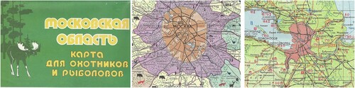
Figure 1. (a) Moscow oblast, map for hunting and fishing, 1983 – cover; (b) map extract; (c) Leningrad oblast, 1984 – map extract.
Methodology
The study presented in this paper involved the examination of 42 Soviet cartographic products (comprising road atlases and tourist maps appearing as sheets or booklets) that were published between 1963 and 1989. The vast majority were obtained from a single source in Latvia, the bookshop Jāņa Sēta, and several had been deaccessioned from a single library. The selection is notably light on maps of the Baltics – most likely because these would have been sold quickly by the bookshop in Riga, and titles selected were those known to have been published for more than one year using a similar cover design, thereby reflecting a greater continuity in their availability to the public.
To narrow the focus, only those maps covering a region, such as an oblast or republic, or a main route were selected. For consistency, road atlases lacking information about points of interest, or maps focusing on a single city, were excluded, although both are worthy of study. Most of the maps in the sample are described as being ‘туристская схема’ or ‘туристская карта’, in effect tourist guides or maps, although some are more clearly linked to car use – a 1971 map of Ukraine and Moldova is called a ‘карта автомобильных дорог’ (automobile road map), for example, and it lacks textual information but, unusually, carries a scale (1:1,750,000).
In analysing the content of the maps, the methodology is based on that developed for current work examining similar road maps issued by, or on behalf of, petrol and oil companies. This builds on the classification of topographical map symbologies in Kent and Vujakovic (Citation2009) by extending their analysis to include elements surrounding the main map – covers, other graphical or cartographic elements and text – sometimes referred to as the perimap (Wood and Fels, Citation2009; Azócar and Buchroithner, Citation2014; Morcrette, Citation2018).
Map areas
The regional maps examined here include several of a complete Soviet republic: Georgia, Azerbaijan, Armenia, Estonia, Latvia, Byelorussia, and – always conjoined – Ukraine with Moldavia. Just one covered an Autonomous Soviet Socialist Republic (Bashkir), but several were based on the next administrative level, the oblast, including Kirov, Pskov and Leningrad, as well as one map of Moscow oblast specifically designed for hunting and fishing.
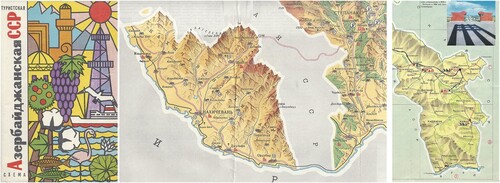
Oblast or republic maps generally stay within the borders – this even applies for Azerbaijan where the exclave of Nagorno-Karabakh floats in neighbouring Armenia, tied umbilically by a single road. A 1973 map of Armenia makes no reference to the role of this road as a link (). This approach is not dissimilar from European national maps or US state maps, but was rigidly applied. The Armenia map is the only case in this sample to list all the available tourist maps within the republic: these comprised 11 route (strip) maps, 6 of cities and 1 of Lake Sevan; the strip maps cost 20 kopecks each and the other maps 10 or 15 kopecks.
Figure 2. (a) Azerbaijan SSR, 1970 – cover; (b) map extract showing Nagorno-Karabakh enclave; (c) extract from 1973 map of Armenia showing connecting territory.
That maps of the Moscow or Leningrad oblasts were available for inclusion in the sample is not surprising; in the mid-1980s it was estimated that each summer more than a quarter of residents of Moscow or Leningrad rented a dacha and a further 35% had access to one (Morton, Citation1980; Raynes, Citation1984). But it was also possible for relatively privileged Soviet citizens to fly to more distant destinations: there were 196 regional airports served directly by Moscow, although – perhaps surprisingly – only one of the 42 maps marked any airports: a 1981 map of the western environs on Moscow itself. By 1987, Aeroflot – the monopoly airline – carried 115 million passengers on domestic flights, almost one-third the equivalent number in the United States (Sagers and Maraffa, Citation1990). Air travel was second only to rail travel, which still took nearly half of intercity journeys; in contrast road travel – whether collective on long-distance buses, or by private car, had a combined share of under 20%, in part due to the absence of good quality long-distance roads, as the state was reluctant to invest in roads, preferring instead to invest in heavy industry (ibid., Citation1990).
In keeping with their touristic objectives, maps of holiday destinations – Crimea, the Black Sea Coast of the Caucasus, and a number of lakes, including Baikal, Sarychelek, Seliger, Valday and Ritsa – were also studied. Inland zones were less represented in the sample, although these include two examples from Transcarpathia. Given its importance and relative wealth, it is not surprising that there were also maps of the Moscow environs – from the south, west and northeast of the city. If there is a bias towards the Western USSR, it may simply be reflective of the maps’ source – it is perhaps less likely that residents of Riga would holiday in Central Asia than in Crimea or the Caucasus.
The other type of map examined is more distinctive to the Soviet Union – the tourist strip map. While these were relatively common in the early years of motoring in North America with promoted routes such as ‘Blazed Trails’ or the Lincoln Highway (Akerman, Citation1993, Citation2002), by the 1960s they had fallen out of favour except occasionally to show services and attractions close to the new freeways and motorways. Their occurrence in the Soviet Union may not be so surprising: motorists would not be encouraged to stray from approved routes (and might find a lack of serviceable roads if they did) and in many cases may have followed the route from a long-distance bus or train, not a private car. Several maps examined – and not just those in a strip format – refer to officially numbered tour routes, together with the number of days taken by each tour.
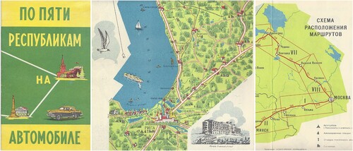
One atlas, ‘Across Five Republics by Automobile’ (По Пяти Республикам на Автомобиле, 1968), essentially just contains six strip maps taking users in a loop from Moscow through Minsk, Vilnius, Riga, Tallinn and Leningrad to return to the capital. Only one stage offers two routes – from Vilnius to Riga with route III taking a more or less direct line and route IV traversing an S-curve through Ukmergė and Daugavpils. Towns are indicated pictorially, and the brochure is liberally illustrated by line drawings set on a pale blue wash. Although Riga recognizably shows the old town on the map, the associated drawing is of the Kemeri sanatorium in nearby Jurmala. Booklet maps like this, with each section aligned to a defined route, required pages to be aligned with North at a different angle on each page, but some of the maps which might be expected to have a conventional North at the top of the page are also aligned optimally to the paper ().
Figure 3. (a) Across Five republics by Automobile, 1968 – cover; (b) map extract showing Riga – note angle of North arrow; (c) extract from schema showing division of strips and legend.
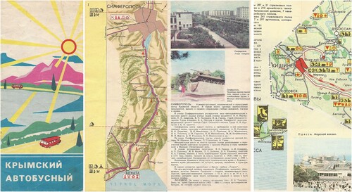
Another strip map, again in the form of a small booklet, provides a circular tour of Southern Crimea. Although described as being by bus (Крымский Автобусный, 1974) it marks petrol and repair garages, as well as providing a page of road signs, suggesting a possible dual purpose (a, b).
A folding map of a tourist route across Ukraine and Moldavia (По Украине и Молдавий Туристский Маршрут (No 301), 1974) has a single route zigzagging across the sheet between blocks of text and photographs. The highlighted route, in red, uses rail from Kiev to Chisinau, but road from Chisinau to Odessa (c). Most roads – whether or not on the highlighted route – have parallel dots to indicate that they are also bus routes. Had a tourist wished to follow this route by car it would have been possible, but difficult, as the main highways fall outside the area mapped. The accompanying text starts by asking rhetorically:
What could be more pleasant than to see with your own eyes the vastness of our Motherland, to know its history, to feel its beauty and greatness in your heart, to introduce you to art, to meet good people!
Unusually, this map is directly linked to an organized tour (the all-union N301 in the title). An inset box offers a 20-day tour, starting with five days in Kiev (in the Friendship hotel), before eleven days in three Moldovan cities, and finishing with four in Odessa. The cost is quoted as 104 roubles in summer and 94 in winter – but there is no indication of whether this includes travel, accommodation and any excursions. This map, then, was not designed for independent use, nor for residents of either of the two republics; its subsequent appearance in Latvia is thus unremarkable. Despite this, much of the information provided relates to towns and villages on either side of the main route. Assuming users travelled by train from Kiev to Chisinau, much of this information would have been superfluous.
Figure 4. (a) Crimean Autobus strip map, 1974 – cover; (b) map 1 with gazetteer page facing. (c) Across Ukraine and Moldavia Tourist Route 210-68-01 (No 301) – extract showing Chisinau with rail and bus routes highlighted in red.
Production
Every map carries detailed production information in a common format; except for the cased road atlases, this information is included on the rear cover. All the examined maps credit GUGK (Главное Управление Геодезии и Картографии при Совете Министров СССР) the Main Directorate of Geodesy and Cartography under the Council of Ministers of the USSR, which was charged with producing domestic mapping. All maps in the sample are typeset in Russian using the Cyrillic script, although maps of non-Slavic areas, such as Riga, can occasionally be found in Roman script (Barbans, Citation2019). GUGK was the main body responsible for both military and civilian cartography of domestic territories, and was founded in 1919 and renamed several times before adopting its final name in 1939. As the state mapping organization, GUGK was mandated to map all Soviet territory except within 10 km of certain military sites, which were restricted to military topographers and naval hydrographers (Postnikov, Citation2002).
The public availability of detailed Soviet maps, which had been bought in large numbers by the Germans in the early stages of the Second World War, had been thought to assist enemy advances during the early stages of Operation Barbarossa – the invasion of the USSR in June 1941. This led to the withdrawal, and in some cases the destruction, of large-scale maps of Moscow, and restrictions on the circulation of the pre-war ‘Great Soviet Atlas'. Special instructions issued in 1948 required that topographic maps should be classified as secret or for official use only, and if lost or used negligently the perpetrators could be prosecuted. Maps at the scale of 1:100,000 were accordingly regarded as secret and maps for the public had to be compiled using the 1:2,500,000 map of the Soviet Union, enlarging elements as necessary to the required scale.
For the first decade or so after the end of the Second World War, the priority for GUGK was the re-survey of the Soviet Union for administrative or official purposes, resulting in good-quality topographic maps, rather than maps for motorists or tourists (Cruickshank, Citation2012). Even so, there appears to have been a further delay before more of these leisure maps became widely available from the mid-1960s.
Postnikov (Citation2002), who had previously worked at GUGK, further reported that most road and tourist maps, including those of holiday regions and oblasts, were produced at the scale of 1:600,000. However, with the exception of the excluded road atlases, only three of the maps examined for this study carry any indication of scale at all, and only one of those is at 1:600,000. The projection is never stated, as from the 1970s onwards a special projection was used that incorporated deliberate random distortions.
GUGK operated a number of factories, which carried out some cartographic functions as well. Of the maps examined, two-thirds came from factory No.5, formerly located in the premises of the Latvian Geospatial-Information Agency in Riga, with fewer from factories 2, 8 and 10. Only the most recent map in the sample, of Lake Baikal (1989), lacked a factory number, although in the spirit of glasnost it volunteers that it was produced at the Novosibirsk Cartographic Factory, also giving its address. The factory numbers changed from time to time (CIA, Citation1954), but No.2 seems to have specialized in road atlases and maps of the Ukraine or Crimea, so it may be the facility in Kharkov.
The production information given on the maps usually names the editor and technical editors. The author of the text and photographer(s) appear on tourist maps with, on some maps, an additional consultant; it appears that a significant proportion were women – since their surnames use the feminine form. In comparison with the analysis of names on Soviet military mapping (Cruickshank, Citation2012) this indicates that women were also assigned to undertake the cartographic production of tourist maps.
All the maps examined in this sample are either sheet maps or booklets, although a 1984 map of the Leningrad oblast had both a sheet map and a separate 12-page text booklet slipped into a folded paper pocket. This composite format allowed the text to be printed on cheaper paper using a single colour of ink, freeing up space on the reverse of the main map to include an overview map, a larger scale map of the environs of Leningrad, a street plan of the city centre and a number of photographs, as well as lists of museums and other points of interest. A 1966 map of Crimea also had a loose cover, allowing for the map, unusually, to be printed on just one side of the map – most had the main map on one side and additional information on the reverse. All maps were printed on good quality paper stock when compared, for example, with the maps of Eastern European satellite states distributed through their tourist boards.
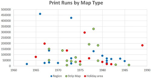
Most maps were printed in limited quantities compared to numbers in North America or Europe. The print run is often stated on the back cover or back matter, and print runs in this sample rarely exceeded 200,000. The excluded hardback atlases had print runs in excess of 500,000, and the Moscow maps of 1 million each. In contrast, only four of the tourist maps ran to more than 200,000 copies, and the highest two were both of Crimea – the 1966 edition reaching 426,000 copies. At the other end of the scale, nine titles had 25,000 or fewer copies, with the smallest run seen being just 6,000 for a 1972 map of the Lake Sarychelek region in western Kyrgyzstan ().
Figure 5. Print runs plotted against publication year and observed type of map.
Cartography
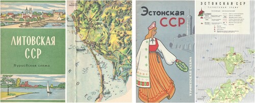
The maps produced in the 1960s were generally pictorial in style, with relief shown through hill shading. Towns and villages were typically shown as idealized groups of buildings, although some landmarks can be discerned; the inevitable communal housing blocks were not. Over time, the style simplified considerably; a 1968 map of Estonia shows a transitional style with three town and village symbols, still redolent of actual buildings. On some maps, administrative status was indicated by different font size, and all maps were rigorous in marking different administrative boundary levels ().
Figure 6. (a) Lithuania SSR, 1963 – cover; (b) map extract. (c) Estonia SSR, 1968 – map extract and legend.
Content
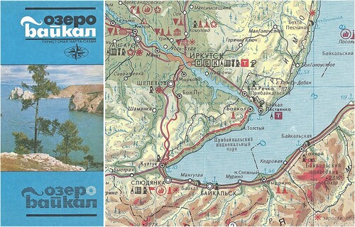
Land forms were simplified too, although around half of the maps in the sample utilized some form of hill shading. Fewer maps had hypsometric tinting, and just two examples – both of the Moscow environs – used contours, although they were not tied to specified heights. Finally, by 1989, rather like Western road maps, improved techniques allowed more details to be shown, as on the map of Lake Baikal (). Otherwise, the background was typically a light green, with woods almost always marked (although not always in the legend); some maps added areas or marsh or sand.
Figure 7. (a) Lake Baikal, 1989 – cover; (b) map extract. Note it is not intuitive which of the red lines south of Irkutsk (for example) represents the railway, and which the road.
Roads and railways were portrayed more consistently. Roads were generally red; tourist maps typically divided roads into two categories: main and other – these are sometimes described as being automobile roads (автомобильные дороги), but also sometimes as trackless roads (безрельсовые дороги) to distinguish them from railways. Maps intended for motorists expanded the categories to include roads of national, republican or regional importance. Potentially useful information about road conditions, such as surface or widths, was not shown, nor were gradients, although a small number of passes were marked in mountainous regions. Obstructions such as bridges or weight limits were completely ignored, in stark contrast to the military mapping. Road distances were not universally provided, but maps oriented towards motoring tended to show them at two levels – between each settlement or road junction, and between major towns indicated using conventional tick marks. Earlier maps showed fewer distances: the 1968 booklet map ‘Across 5 Republics by Automobile’ only marks major distances on the key map.
Railways were almost invariably black, occasionally marking stations – but the late Lake Baikal map used a similar red line for both main roads and railways, creating an opportunity for confusion. A 1973 booklet map, ‘Leningrad Tallinn Riga Vilnius’, looks at first sight to be for road users, but its main red lines represented railways, not roads, and section 6, running from Vilnius to Daugavpils, only shows the rail route. Rail ferries (and distances) were widely shown, as were ports. Other water features (lakes, rivers, canals) were mapped but only occasionally included in the legend (described as navigable channels); natural features such as waterfalls appeared only in the 1968 Estonia map.
Main maps only rarely included an inset at a larger scale centred on the main city in order to provide additional information, although this was done for Rostov-on-Don on a 1978 Rostovskaya oblast map, and for Baku on a 1970 Azerbaijan map. It was more common to include a town plan of the main city in the reverse of the map. On tourist maps, these frequently included keyed lists of points of interest, in contrast to the sometimes very basic plans included on road maps or atlases.
Symbology
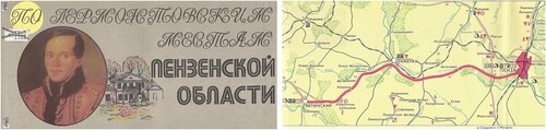
Almost all the maps examined in the sample contained a reasonably comprehensive legend with only basic elements such as lakes and rivers omitted. Earlier (1960s) maps were more likely to assume a knowledge of conventional symbols for features such as woods, roads, railways or settlements, and a couple of maps helped users by drawing a steaming train alongside the railway. Indeed, a pictorial 1963 Lithuania map contained just two symbols in its legend – a red flag for tourist bases and a number in a circle to link points of interest to the surrounding gazetteer. These early maps sometimes placed the symbols on an unimportant part of the map; later maps generally devoted an entire panel or substantial inset box to permit a full legend. In extremis, the legend could almost be disproportionate to the map: on a 1982 map of sites associated with the poet Mikhail Lermontov in the Penza oblast (По Лермонтовским Местам Пензенской Области), the main map measures just 490 × 115 mm; the legend beneath it measures 220 × 115 mm ().
Figure 8. (a) Lermontov’s places – Penza Oblast, 1982 – cover; (b) map extract. This is the entire tourist route, highlighted in red.
Symbols included in the legend of each map were limited to those used. As an example, two 1981 maps from a single series – the western and northeastern outer suburbs of Moscow – used symbols drawn from a common set. The western section listed airports and fishing bases; the northeastern section omitted these but included spot heights and tourist equipment rental points ().
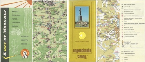
Figure 9. (a) To the South of Moscow, 1968 – cover; (b) map extract. (c) Moscow Environs/West, 1981 – cover; (d) map extract and legend.
Symbols were either black, for tourist administration, accommodation and motoring facilities, or red, for tourist attractions. Some earlier maps used a very small number of symbols, mainly in black, and failed to mark any tourist attractions, despite being drawn in a pictorial style. Only one symbol – for the sources of mineral waters – was customarily in blue. On dedicated road maps, the symbols were often grouped into a black outlined box, commonly with a yellow fill.
Some symbols were reused, with potentially confusing results. The internationally recognized tent symbol was mainly used for camping, but since few Soviet citizens had their own camping gear, the symbol’s use was often extended to encompass auto tour bases (guesthouses and camping). However, it was occasionally used for something completely different: on a 1973 Armenia map it was coloured red to denote ancient burial sites.
The specificity of symbols also varied. A symbol generally used for architectural sites was restricted on a 1984 Leningrad oblast map to ancient fortresses and defensive structures, whereas the unfilled oak leaf symbol generally denoted a catch-all of interesting natural objects that was occasionally expanded to include parks. The standard symbol of crossed swords for a battlefield also sometimes had a modified meaning – such as for an ‘ice battle’ on a 1985 map of the Pskov oblast, or for the 1773–1775 peasants’ rebellion led by Pugachev on a 1981 map of the Bashkir ASSR. Another widely used symbol, of a pair of red triangles forming an hourglass, was mainly used to denote resorts, but sometimes extended to recreation areas or sanatoria (which occasionally used the Bowl of Hygieia instead).
Very specific attractions sometimes reused an existing symbol, or sometimes a bespoke one. Several maps showed sites associated with Lenin, but only two examples selected a bespoke symbol of an ‘Л’ in a red circle – others most commonly used a red star in a circle. The 1985 Lake Baikal map required a special symbol for sites associated with the Decembrists, but simply chose to invert the red triangle commonly used for denoting the places of life and work of significant people.
A symbol composed of three black squares in a pyramid provides an example of different, non-representative uses. On a 1975 map of Transcarpathia, it was used for drag lifts, presumably in a skiing area. Three years earlier, on a map of the ‘Golden Ring of Russia’ (Золотое Кольцо России, in effect a circular tour to the northwest of Moscow as far as Kostroma), the same symbol had been shown as a subset of archaeological monuments representing fortified settlements. This map also used some unique symbols not seen elsewhere when dividing architectural monuments into the three categories of Religious, Military and Civilian – a distinction not found on any other maps in the sample.
Overall, it appears that GUGK cartographers had a standard set of symbols – possibly even a Soviet equivalent of Letraset – to apply to their maps, but a degree of freedom on how to use them. These symbols differed in both detail and extent from the standard symbols used on military maps or city plans (Davis, Citation2021), which lacked cultural facilities but included much detail on industry (Davies and Kent, Citation2017).
Conclusions
Soviet tourist maps are similar to Western maps in one very important respect – they are trying to tell a story. In many ways they are more like US Official State Highway maps or National Geographic maps (see Wood, Citation1992: 95–142; Wood and Fels, Citation2009) than the Soviet military maps which have emerged since the end of the Cold War. The Soviet tourist maps are actively promoting an image of the country peppered with ‘historical-revolutionary’ monuments and sites, especially from the Great Patriotic War of 1941–1945, and places associated with outstanding or significant people. Although the photographs and drawings associated with the maps have a range of heroes, one – Lenin – stands above all others on the actual maps, although some poets – Pushkin, Lermontov – are permitted maps of their own.
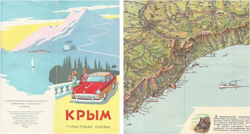
This is also reflected in the cover designs. Almost all are promotional – in the 1960s they were often attractively drawn, showing characters in national costume or local sights. The 1966 Crimea map has an idealized image of a couple photographing a mountain scene in front of their parked Volga motorcar; this freedom would be afforded to a very few privileged citizens (). Around 1972, covers switched to designs with one to three colour photographs typically of city streets, war memorials or lakes, accompanying the map title. Perhaps these are less attractive, but mirrored a similar switch to that of Western road maps issued by petrol companies.
Figure 10. (a) Crimea, 1966 – front and rear covers opened out. Note the production information on the bottom of the rear cover; (b) map extract, using a pictorial style.
Internally, the countryside is seen as a natural place to visit, but facilities are quite limited – tourist bases appear in limited numbers on most maps, but camping sites less frequently. Although some maps offer a prospect of freedom, the collective nature of tourism in the Soviet Union means that sights are more likely to be viewed (and projected) from a defined route.
These maps offer an interesting insight into an under-researched aspect of Soviet life, and display a wide range of cartographic designs and development. Although often overlooked as a genre in comparison with Soviet military mapping, they are worthy of further study.
Disclosure statement
No potential conflict of interest was reported by the author(s).
Additional information
Notes on contributors

Ian Byrne
Ian Byrne is in his final year of doctoral research into the cartographic development of promotional road maps issued by or for petrol and oil companies, including their symbology, from the earliest examples to the era of online mapping. Prior to commencing his academic studies into the subject, Ian had been a collector of such maps for over 25 years, and is a member of the British Cartographic Society, the Charles Close Society and a Board Member (and assistant webmaster) for the Road Map Collectors Association (USA). He has had articles published in peer-reviewed journals, as well as having been a regular contributor to hobbyist magazines internationally. Ian’s non-academic website (petrolmaps) has over 2,000 images – mainly of road map covers – of European and North African maps. Professionally, Ian is a chartered environmentalist working in energy conservation and climate change mitigation.
References
- Akerman, J.R. (1993) “Selling Maps, Selling Highways: Rand McNally’s ‘Blazed Trails’ Program” Imago Mundi 45 pp.77–89 DOI: 10.1080/03085699308592765.
- Akerman, J.R. (2002) “American Promotional Road Mapping in the Twentieth Century” Cartography and Geographic Information Science 29 (3) pp.175–192 DOI: 10.1559/152304002782008459.
- Azócar, P. and Buchroithner, M.F. (2014) Paradigms in Cartography: An Epistemological Review of the 20th and 21st Centuries Heidelberg: Springer-Verlag.
- Barbans, J. (2019) 100 Gadi 100 Kartēs Riga: Jāņa Sēta.
- CIA (1954) “Provisional Intelligence Report: The Organization of Soviet Geodesy and Cartography” Central Intelligence Agency (Approved for Release 1999, Ref CIA-RDP79-0108A00080001-0).
- Cruickshank, J.I. (2012) “Teaching OS Map Reading as a Foreign Language (TOFL)” Sheetlines 94 pp.28–29.
- Cruickshank, J.I. (2020) “A Preliminary Study of the Soviet Topographic Maps of the UK and Their Sources” Sheetlines 119 pp.30–43.
- Davies, J. (2005) “Uncle Joe Knew Where you Lived” The Story of Soviet Mapping of Britain (Part II) Sheetlines 73 pp.1–15.
- Davies, J. and Kent, A.J. (2017) The Red Atlas: How the Soviet Union Secretly Mapped the World. Chicago: University of Chicago Press.
- Davis, M. (2021) “A Cartographic Analysis of Soviet Military City Plans” Cham, Switzerland: Springer.
- Kent, A.J. and Vujakovic, P. (2009) “Stylistic Diversity in European State 1:50 000 Topographic Maps” The Cartographic Journal 46 (3) pp.179–213 DOI: 10.1179/000870409X12488753453453.
- Morcrette, Q. (2018) “Tracer la route: les cartes d’itinéraire du papier à l’écran, usages et représentations: contribution pour une étude diachronique comparée (France/Etats-Unis)” (PhD thesis) Géographie. Université de Lyon Available at: https://tel.archives-ouvertes.fr/tel-02145228 (Accessed: 8th February 2021).
- Morton, H.W. (1980) “Who Gets What, When and How? Housing in the Soviet Union” Soviet Studies 32 (2) pp.235–259 DOI: 10.1080/09668138008411295.
- Postnikov, A.V. (2002) “Maps for Ordinary Consumers Versus Maps for the Military: Double Standards of Map Accuracy in Soviet Cartography, 1917–1991” Cartography and Geographic Information Science 29 (3) pp.243–260 DOI: 10.1559/152304002782008431.
- Raynes, A. (1984) Quality of Life in the Soviet Union New York: Research Foundation of the City University of New York.
- Sagers, M. and Maraffa, T. (1990) “Soviet Air-Passenger Transportation Network” Geographical Review 80 (3) pp.266–278 DOI: 10.2307/215304.
- Svenningsen, S.R. and Perner, M.L. (2020) “Soviet Cold War Maps: Examining the Organization and Practices of Production Through the Case of Denmark” The Cartographic Journal DOI: 10.1080/00087041.2019.1660518.
- Wood, D. (1992) The Power of Maps New York: The Guilford Press.
- Wood, D. and Fels, J. (2009) The Natures of Maps Chicago: The University of Chicago Press.