

ABSTRACT
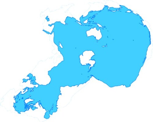
This paper presents the Cameron Aquatic Projection, a novel concept designed to depict the world’s surface hydrosphere as it is, a continuous unbroken unit including oceans and rivers. After a review of related past projections, the paper will describe the parameters of the projection, according to the existing layout of surface water on Planet Earth. This description of the design principles is followed by the mathematical realization of the proposal. The article concludes with completed examples of the projection and suggests future applications.
GRAPHICAL ABSTRACT
Acknowledgements
We would like to thank Jennifer Johnston of Inspirit Cartography for her invaluable contribution. Without her cartographic skills it would not have been possible to put together this study.
Disclosure statement
No potential conflict of interest was reported by the author(s).
Data availability statement
The authors confirm that the data supporting the findings of this study are available within the article and its supplementary materials.
Notes on the contributors
 Duncan Cameron holds an MBA degree from Henley Management College and a degree in Art History. He worked for the British Council in various parts of the Middle East and South America. He has published books and articles not only in the field of business but also on history. Walking beside the sea near his home in Brighton led him to the idea of the map projection presented here.
 Kerkovits Krisztián is an assistant professor. His main interest is to develop low-distortion map projections and analysing different measures of distortion. Furthermore, he is also interested in problems occurring in GIS when reprojecting small-scale maps and in the history of map projections. He defended his PhD in 2019 on the topic of minimum-distortion mappings. He lectures on courses in map projections and geodesy.
Correction Statement
This article has been corrected with minor changes. These changes do not impact the academic content of the article.