Abstract
The Oklahoma Mesonet, an automated statewide system of 115 remote meteorological stations, provides observations through an interactive website, www.mesonet.org. Precision sensing enables estimation of winter wheat grain yield potential in midseason, which in turn has potential to increase fertilizer-use efficiency. Knowing cumulative evapotranspiration could help to improve the accuracy of yield potential predictions. We evaluated how well the evapotranspiration value of a chosen test station can be predicted from values of surrounding Oklahoma Mesonet stations using the nearest neighbor, local average, and the inverted weighted distance methods. All three interpolation methods enabled us to accurately predict the actual cumulative evapotranspiration value at the test Oklahoma Mesonet station. The nearest neighbor method is the easiest and the quickest interpolation method, and it also proved the most accurate (R2 = 0.98). Results of this study underline the value of Oklahoma Mesonet weather data to Oklahoma crop producers for improved fertilizer-use efficiency.
Introduction
Precision sensing techniques using the optical active-light handheld GreenSeeker sensor developed at Oklahoma State University (OSU) in conjunction with N-Tech Industries enables estimation of winter wheat grain yield potential (YP) midseason. GreenSeeker sensors are used to measure crop canopy reflectance and calculate the normalized difference vegetative index (NDVI). The YP predicted midseason enables accurate fertilizer topdress recommendations based on nutrient status of the crop. This approach has great potential to increase fertilizer-use efficiency because fertilizer rates are adjusted depending on actual crop need. Evapotransipiration (ET) is the total amount of soil water used for transpiration by the plants plus evaporation from the soil surface (CitationIrmak and Haman 2003). The crop ET indicates the amount of water utilized by the crop and its environment. Preliminary analysis of winter wheat yield data collected from OSU long-term experiments combined with ET data obtained from the Oklahoma Mesonet suggested that cumulative ET beginning 30 days prior to planting through first 2–3 months of the cropping season could be used to improve the accuracy of YP prediction in winter wheat (J. B. Solie and W. R. Raun, personal communication). The following question should be addressed if crop producers are to use Oklahoma Mesonet cumulative ET data to estimate winter wheat YP in their fields: Which ET values can be used when a producer's farm is located between the Mesonet stations?
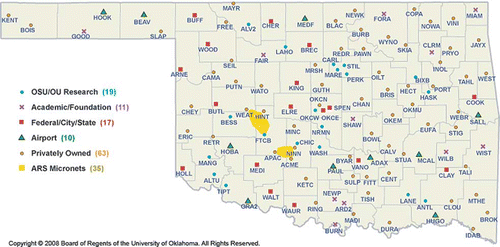
Approximately 115 Mesonet stations are located statewide () within 20 to 30 miles of each other with at least one station situated in each of Oklahoma's counties (www.mesonet.org). Daily ET data are available to researchers and crop producers on the Oklahoma Mesonet site (http://agweather.mesonet.org/index.php/data/section/crop).
Figure 1. Location of Oklahoma Mesonet stations with IDs (color figure available online). Source: CitationOklahoma Mesonet, 2008. Oklahoma Mesonet Overview. Available at http://www.mesonet.org/
Interpolation is used to estimate unknown values based on measured surrounding values. Three interpolation techniques (nearest neighbor, local average, and inverse weighted distance) are commonly used for prediction of missing values that vary spatially. The nearest neighbor method implies using the value of the nearest measurement to the unknown value to be estimated. If several values are located at the same distance, the average of those values is used. The local average method entails using an average of all known values within a predetermined distance from an unknown value. The inverse weighted distance interpolation implies that all known values are weighted by the inverse of their distance from the missing value. The unknown value is interpolated by calculating the sum of the weighted values divided by the sum of the weights. The objective of this article is to evaluate how well the ET value of a chosen test station can be predicted from known cumulative ET values of surrounding Oklahoma Mesonet stations using these methods.
Materials and Methods
Mesonet station 54 (KING), located 2.0 miles northeast of Kingfisher, Kingfisher County, Oklahoma (35° 52′ 49″ N and 97° 54′ 40″ W) was chosen as a test station. This station was chosen for the following reasons. First (considering agronomy), Kingfisher County is located in the middle of the primary winter wheat–growing area of Oklahoma. Second (considering geography and data point availability), the Kingfisher station is situated relatively far away from the Oklahoma state border, with multiple Mesonet stations on each side. A total of 14 Oklahoma Mesonet stations were included in the analysis (). Using latitude and longitude provided at http://www.mesonet.org/, the distances from the Mesonet stations to Kingfisher station were calculated using software (CitationByers 1997) available athttp://www.chemical-ecology.net/java/lat-long.htm. Cumulative ET data for periods of 4 months (1 October through 31 January) for five cropping years (2003–2004 through 2007–2008) were included in the analysis using all three interpolation methods.
Table 1 Mesonet station, station IDs, and distance to Kingfisher, Oklahoma, Mesonet station
The nearest neighbor interpolation method implies predicting an unknown value by averaging the known values of the nearest neighbors. For the nearest neighbor interpolation, cumulative ET data from KING and three Oklahoma Mesonet stations within a 30-mile radius were analyzed. The average value of cumulative ET for the three nearest adjacent Oklahoma Mesonet stations surrounding KING was used to correlate with the value of cumulative ET for the KING station.
The local average interpolation method entails predicting a missing or unknown value by averaging all the known values within a specified radius. For the local average interpolation, cumulative ET data from KING and seven Oklahoma Mesonet stations within a 40-mile radius were analyzed. The average value of cumulative ET for seven Oklahoma Mesonet stations surrounding KING (the nearest neighbors) was used to correlate with the value of cumulative ET for the KING station.
The inverted weighted distance interpolation method also involves predicting an unknown or missing value by analyzing the neighboring known values within a certain radius. However, unlike with the nearest neighbor method, the known neighboring values are not simply averaged but are weighted based on their distance from the unknown value to be predicted. This approach implies that the importance (weight) of the nearby values is proportionate to their distance from the unknown value: the closer the known value to the missing value being predicted, the greater the weight that is assigned to its value. Then, the missing value is calculated as the sum of the weighted values divided by the sum of the assigned weights. For the inverted weighted distance interpolation, cumulative ET data from KING and 14 Oklahoma Mesonet stations within a 50-mile radius were analyzed. The stations located within 25 miles (MRSH, GUTH, and ELRE) from the test station were assigned the weight of 1, those located 25 to 37.5 miles from the KING station (WATO and LAHO) received the weight of 0.75, and, finally, those situated 37.5 to 50 miles were assigned the weight of 0.5.
Results and Discussion
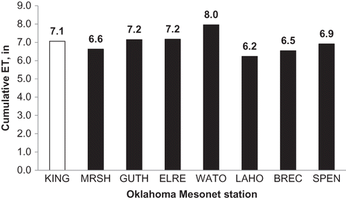
show the cumulative ET values for analyzed Oklahoma Mesonet stations located within a 40-mile radius from the KING test station for five consecutive cropping seasons. The cumulative ET tended to be greater for WATO station in all five cropping seasons, whereas ET for all other stations were comparable within any given year. Temporal variability in cumulative ET was apparent when comparing cropping seasons. Specifically, cumulative ET values were lower for all Oklahoma Mesonet stations in 2004–2005 cropping season (ranging from 4.6 to 5.7 in) () and relatively greater in 2005–2006 cropping season (8.5 to 10.2 in) (). Other three growing seasons had similar cumulative ET values for all evaluated Oklahoma Mesonet stations. It is important to notice that cumulative ET values were very similar for the KING station and SPEN station (located 40 miles away, farther than other Oklahoma Mesonet stations analyzed) in four of five cropping seasons.
Figure 3. Cumulative evapotranspiration values for the test station (KING) and for seven neighboring Oklahoma Mesonet stations (MRSH, GUTH, ELRE, WATO, LAHO, BREC, and SPEN) located within a 40-mile radius, 1 October 2004–31 January 2005.
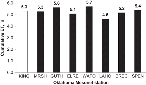
Figure 5. Cumulative evapotranspiration values for the test station (KING) and for seven neighboring Oklahoma Mesonet stations (MRSH, GUTH, ELRE, WATO, LAHO, BREC, and SPEN) located within a 40-mile radius, 1 October 2006–31 January 2007.
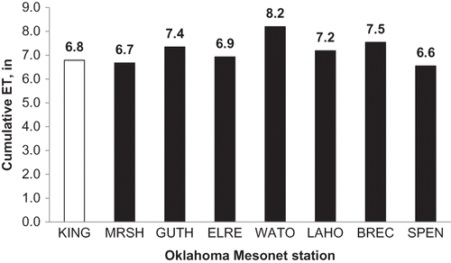
Figure 6. Cumulative evapotranspiration values for the test station (KING) and for seven neighboring Oklahoma Mesonet stations (MRSH, GUTH, ELRE, WATO, LAHO, BREC, and SPEN) located within a 40-mile radius, 1 October 2007–31 January 2008.
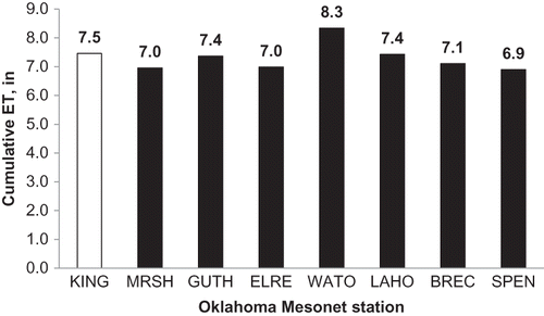
Figure 4. Cumulative evapotranspiration values for the test station (KING) and for seven neighboring Oklahoma Mesonet stations (MRSH, GUTH, ELRE, WATO, LAHO, BREC, and SPEN) located within a 40-mile radius, 1 October 2005–31 January 2006.
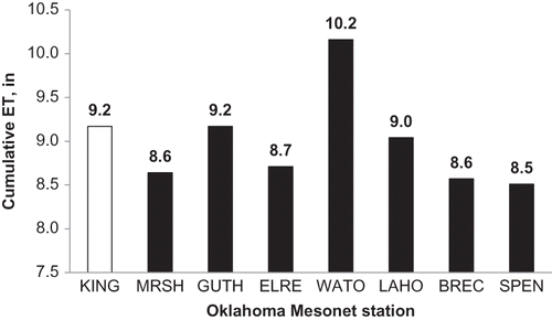
Figure 2. Cumulative evapotranspiration values for the test station (KING) and for seven neighboring Oklahoma Mesonet stations (MRSH, GUTH, ELRE, WATO, LAHO, BREC, and SPEN) located within a 40-mile radius, 1 October 2003–31 January 2004.
, , and show the relationship between the cumulative ET at KING Oklahoma Mesonet station calculated using known ET values obtained from Oklahoma Mesonet database (actual ET) and the cumulative ET values predicted using three interpolation methods (interpolated ET).
Figure 9. The relationship between measured cumulative evapotranspiration at test station (KING) and the cumulative evatranspiration at KING station calculated using the inverted weighted distance interpolation method and evatranspiration data for 13 adjacent Oklahoma Mesonet stations located within a 50-mile radius, 1 October–31 January for the 2003–2004 through 2007–2008 cropping seasons (color figure available online).
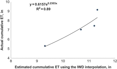
Figure 7. The relationship between measured cumulative evapotranspiration at test station (KING) and the cumulative evapotranspiration for KING station calculated using the nearest neighbor interpolation method and evatranspiration data for three nearest neighboring Oklahoma Mesonet stations (MRSH, GUTH, and ELRE) located within a 25-mile radius, 1 October–31 January 31 for the 2003–2004 through 2007–2008 cropping seasons (color figure available online).
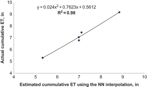
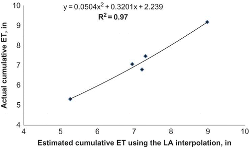
Figure 8. The relationship between measured cumulative evapotranspiration at test station (KING) and the cumulative evapotranspiration for KING station calculated using the local average interpolation method and evatranspiration data for seven adjacent Oklahoma Mesonet stations (MRSH, GUTH, ELRE, WATO, LAHO, BREC, and SPEN) located within a 40-mile radius, 1 October–31 January for the 2003–2004 through 2007–2008 cropping seasons (color figure available online).
The actual cumulative ET at KING was strongly correlated (R2 = 0.98) with the cumulative ET determined using the nearest neighbor interpolation and ET data from three nearest neighboring Oklahoma Mesonet stations (MRSH, GUTH, and ELRE) (). This shows that the missing or unknown cumulative ET value can be predicted with 98% accuracy using the nearest neighbor interpolation method.
The local average interpolation enabled us to estimate the actual cumulative ET value with 97% accuracy. The actual cumulative ET at test station was strongly correlated (R2 = 0.97) with the cumulative ET determined using the local average method and ET data for seven adjacent Mesonet stations (MRSH, GUTH, ELRE, WATO, LAHO, BREC, and SPEN) ().
The actual cumulative ET at test station was also strongly correlated (R2 = 0.89) with the cumulative ET value calculated with the inverted weighted distance method using ET data for 13 Mesonet stations within the 50-miles radius (MRSH, GUTH, ELRE, WATO, LAHO, BREC, SPEN, MARE, MINC, HINT, FAIR, STIL, and PERK) (). This result indicates that using the inverted weighted distance interpolation enables us to predict an unknown cumulative ET value with 89% accuracy.
Conclusions
The analysis of data for five consecutive cropping seasons shows that if a crop producer wants to use Oklahoma Mesonet cumulative ET data for estimation of winter wheat YP, the cumulative ET value for the particular field could be accurately estimated using the known cumulative ET values of surrounding Oklahoma Mesonet stations. All three interpolation methods (nearest neighbor, local average, and the inverted weighted distance) enabled accurate prediction the actual cumulative ET value at the test Oklahoma Mesonet station (KING). The analysis of cumulative ET data showed that the nearest neighbor interpolation method could be the most appropriate for prediction of an unknown cumulative ET value for a point located between the Oklahoma Mesonet stations. The nearest neighbor method is the easiest and the quickest interpolation method but also proved the most accurate (R2 = 0.98). Results of this study underline the value of Oklahoma Mesonet weather data to Oklahoma crop producers for improved fertilizer-use efficiency.
References
- Byers, J. A. 1997. Surface distance between two points of latitude and longitude. Available ataccessed 11 May 2011 http://www.chemical-ecology.net/java/lat-long.htm (http://www.chemical-ecology.net/java/lat-long.htm)
- Irmak, S., and D. Z. Haman. 2003. Evapotranspiration: Potential or reference? IFAS Extension. Gainesville: University of Florida. Available ataccessed 11 May 2011 http://edis.ifas.ufl.edu/pdffiles/AE/AE25600.pdf (http://edis.ifas.ufl.edu/pdffiles/AE/AE25600.pdf)
- Oklahoma Mesonet. 2008. Overview. Available ataccessed 11 May 2011 http://www.mesonet.org/ (http://www.mesonet.org/)