Site details
Lake Blatisto [41° 37′ 17.26″ N, 24° 40′ 41.27″ E; 1540 m above sea level (a.s.l.)] belongs to the group of the Smolyan lakes situated in the coniferous belt of the Central Rhodopes Mountains in Bulgaria on several swampy terraces along a small river in an area with a pyroclastic geology of Oligocene age, consisting of rhyolite. The lakes were formed by landslides originating from failure of the southern slope of the surrounding mountain ridge, probably after an earthquake. The lake is 178 m long and 158 m wide, with an area of c. 1.7 ha and a maximum water depth of 4 m (CitationIvanov, 1964). The northern and western slopes are covered by spruce forest with some admixture of Abies alba Mill., Pinus sylvestris L. and Juniperus communis L. (CitationBondev, 1991). Nearly 60% of the lake surface is covered by Sphagnum islands. The shores of the lake are overgrown by Carex acuta L., Carex echinata Murr., Carex rostrata Stokes, Juncus effusus L., Eleocharis palustris (L.) R. Br., Equisetum hiemale L., Equisetum fluviatile L. and Menyanthes trifoliata L. The surrounding meadows are dominated by grasses and scattered stands of Pinus sylvestris, Betula pendula Roth. and Juniperus communis. The present-day vegetation composition in the study area has been influenced by grazing of domestic animals, cultivation of cereals and potatoes, timber production and, more recently, the construction of tourist complexes and hotels. The local climate is montane but with a Mediterranean influence and a mean annual temperature of 5–10 °C. The average annual precipitation is 1100 mm with precipitation maxima in June and December. The summers are relatively cool and the winters are mild. The basic soil type is brown forest earth.
Sediment description
The sediment profile is 460 cm deep and was collected with a Streif corer in sections of 1 m from a Sphagnum island in the central part of the lake. The sediments are:
0–150 cm: Sphagnum-Equisetum peat | |||||
150–300 cm: peat with plant remains | |||||
300–370 cm: sedge peat | |||||
370–400 cm: peat with sand | |||||
400–460 cm: sandy gyttja | |||||
Dating
The radiocarbon age of two bulk sediment samples was determined in the Physical Laboratory of the State University of Groningen, the Netherlands. The calibration (95.4% probability) was performed with the OxCal v3.10 program (CitationBronk Ramsey, 2005). Results are:
208–215 cm: GrN 8441, 575 ± 55 bp (ad 1290–1440) | |||||
420–428 cm: GrN 8442, 1530 ± 60 bp (ad 410–640) | |||||
Interpretation
The core was sampled every second centimetre. The pollen sum (100%) includes all pollen grains except those of Cyperaceae and aquatics, spores of mosses and pteridophytes (). Five local pollen assemblage zones (LPAZ) are recognised:
Figure 1. Pollen diagram from Lake Blatisto, Rhodopes Mountains, Bulgaria.
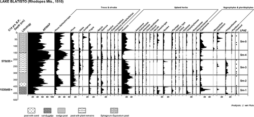
LPAZ Sm-1, 460–400 cm
The relatively low percentages of Pinus diploxylon-type (most probably Pinus sylvestris) and Picea, compared to those of deciduous trees, indicated that forest clearance took place on a large scale in the coniferous belt prior to ad 500, while Fagus and Quercus forests at lower altitudes remained less disturbed. The region of the lakes was intensively used for agricultural activities, cattle- and stock-breeding. The local tribes also cultivated rye (Secale) and other cereals as shown by the pollen records of Cerealia-type (Avena, Hordeum). During this old cultural zone, grazing was quite common indicated by the frequent occurrence of ruderals and grassland species including Rumex, Urtica, Plantago, Cichoriaceae and Caryophyllaceae.
LPAZ Sm-2, 400–315 cm
The period between ad 500 and ad 910 was marked by the rapid regeneration of coniferous forests composed of Pinus, Picea abies and some Abies after a period of human activity. The fields in the highlands were mostly abandoned. The distribution of the deciduous trees was restricted to lower altitudes (Quercetum-mixtum elements) or in more remote locations (Fagus). The stands of Betula could be considered as an intermediate stage between the clearances of the preceding period and the development of the forests. The continuous presence of meadow plants pointed to the existence of grasslands frequently used for grazing.
LPAZ Sm-3, 315–200 cm
The natural forest regeneration until ad 1360 continued with an increasing importance of Fagus, which expanded on the mountain slopes, pushing Picea abies to higher altitudes. Meanwhile, Abies also enlarged its areas forming single-dominant or mixed communities. The terraces were still used for grazing and covered with meadow flora (Rumex, Cichoriaceae, Galium, Plantago, Caryophyllaceae, etc.).
LPAZ Sm-4, 200–135 cm
Around ad 1360, when a short cultural period existed, pioneers (Corylus, Betula) established themselves on more open places and along the edges of the Fagus forests. Afterwards followed the largest enlargement of the coniferous vegetation attributed mainly to Pinus. The conifers formed also mixed stands with Fagus. Meanwhile Quercus, Carpinus betulus and C. orientalis also increased, as well as Alnus on wetter places. However, the large-scale expansion of Pinus could be correlated with the climate change during the Little Ice Age when colder conditions prevailed. The low presence of herbs gives an indication that the fields on the terraces were abandoned by the local people and an undisturbed forest development could take place.
LPAZ Sm-5, 135–0 cm
The last stage in the vegetation development, which started c. ad 1600 was characterised by several alternating regression phases in the forest development caused probably by tree felling, fires and grazing. The increasing intensification of human activities is shown by the cultivation of Secale, Triticum and other cereals (probably Hordeum) and by the extension of pasture land and arable fields. Indications for the practice of stock-breeding are traced by the presence of ruderals and species from grasslands (Rumex, Cichoriaceae, Plantago, Caryophyllaceae, Asteraceae).
Acknowledgements
This contribution was assisted by Henry Hooghiemstra and Bas van Geel from IBED, University of Amsterdam, who kindly provided the archive for Lake Blatisto compiled by our late colleague and friend John van Huis during his field trips to Bulgaria and subsequent laboratory analyses. The editor, Richard Bradshaw, and an anonymous reviewer provided useful comments and suggestions to improve the manuscript.
Related Research Data
References
- Bondev , I. 1991 . “ The vegetation of Bulgaria ” . In Map 1:600 000 with explanatory text , Sofia : St Kliment Ohridski University Press (in Bulgarian .
- Bronk Ramsey , C. 2005 . OxCal Program Ver. 3.10 , Oxford : University of Oxford Radiocarbon Accelerator Unit .
- Ivanov , K. 1964 . The lakes in Bulgaria , Sofia : Nauka i Izkustvo (in Bulgarian .