
Site details
The Galloway Hills are located in southwest Scotland at the western end of the Southern Uplands. The glaciated massif has a maximum height of 843 m (Merrick) above sea level (a.s.l.). The solid geology consists largely of Ordovician and Silurian greywackes and shales with Devonian age granitic and associated igneous intrusions (Stone et al. Citation2012). The landscape is characterised by glacial drift, lakes and extensive areas of blanket and basin mire (Boatman Citation1983). The climate is oceanic, with predominant southwesterly winds, rainfall averaging around 2300 mm per annum and a mean temperature range (February–August) of 2.0‒13.4 °C (cf. Bown Citation1973). Gleyed soils and humus-iron and peaty podzols are common. The original woodland of the Galloway Hills has been described as oak with either birch (McVean & Ratcliffe Citation1962) or hazel (Rackham Citation2006), but little remains other than some Quercus petraea (Matt.) Liebl., Betula pubescens Ehrh., and Sorbus aucuparia L. with an understorey including Vaccinium myrtillus L., Deschampsia flexuosa (L.) Trin., Luzula sylvatica (Huds.) Gaudin and Pteridium aquilinum (L.) Kuhn. There has been extensive conifer plantation. The areas of blanket peat are dominated by Trichophorum-Eriophorum communities in patterned areas, and Molinia-Calluna communities otherwise. The remains of Pinus sylvestris L. stumps in peat are notable. Previous palynological studies span the Late Glacial to the present-day and include peat and lake sites (cf. Newell Citation1990).
Loch Doon IV (55° 12′ 27″ N, 4° 23′ 11″ W) is a deep (4.08 m) mire which is possibly intermediate between blanket and basin forms, at least partially cut-over, and is located 125 m west of the southern end of Loch Doon at an altitude of 220 m a.s.l. The bedrock at the sampling site is tonalite and the surface vegetation at the time of sampling was principally Calluna vulgaris (L.) Hull, Myrica gale L. and Molinia caerulea (L.) Moench with small areas of Sphagnum spp. Full details of the site, sampling and laboratory methods are presented elsewhere (Newell Citation1990).
Sediment description
The core was obtained with a Russian corer (50 cm × 8 cm chamber) other than for the less consolidated surface 50 cm which was collected as a monolith. The stratigraphy is described in .
Table I. Lithostratigraphy of the Loch Doon IV core.
Dating
Seven bulk peat dates were radiocarbon-dated at the University of Groningen, with another at Teledyne Isotopes (). The age–depth curve was constructed using Clam software (Blaauw Citation2010) to interpolate a best-fit smoothed spline employing the IntCal20 calibration curve. Ages within the text are rounded to the nearest five years and the age-depth model is presented in Supplemental material.
Table II. Radiocarbon dates from the Loch Doon IV core.
Interpretation
The pollen sum consists of > 500 land pollen grains with all taxa presented as percentage total land pollen (TLP) (). Charcoal was counted as number of fragments > 10 μm × 10 μm. Data allowing for absolute palynomorph calculations and the recording of non-pollen palynomorphs (NPPs) were collected, and pollen type nomenclature (abbreviated in the text) largely follows that of Bennett (Citation2020).
Figure 1. Percentage diagram for selected pollen and spore taxa at Loch Doon IV.
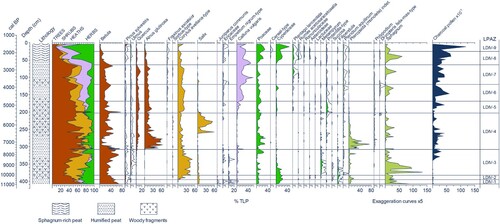
The deposits were accumulating from an estimated early Holocene date of 10,985 cal. bp. Nine local pollen assemblage zones (LPAZs) have been determined (). The basal zone (LDIV-1) shows taxa typical of cold, relatively open conditions (e.g. Salix, Juniperus, Empetrum and Cyperaceae), while the dominant Betula may reflect both dwarf and tree forms. Warming temperatures and the spread of arboreal taxa within the pollen catchment area is shown by the staggered rise of Corylus, Quercus, Alnus and Salix across LPAZs 2–4 (10,510‒5425 cal. bp), along with lower levels of Pinus and Ulmus. Ground flora include Poaceae, Melampyrum and Pteropsida, with Sphagnum in wetter areas. The increased incidence of charcoal may reflect natural fires in part, but the site lies in the midst of many Mesolithic artefactual finds which could also suggest burning related to hunter-gatherer activity (Edwards et al. Citation1984).
Table III. Local pollen assemblage zones (LPAZs) at Loch Doon IV.
The increase in Calluna, Cyperaceae and Potentilla pollen from LDIV-5 indicates the spread of peat and the development of acid soils in the wider area. Possible Neolithic age anthropogenic accentuation of this is shown by the appearance of Plantago lanceolata and the renewed peak in charcoal. The localisation of such events close to the sample site is shown from LDIV-6 (4785‒3840 cal. bp) where increases are seen especially in Calluna, Sphagnum and charcoal.
Reductions in arboreal taxa (Betula, Quercus, Alnus, Corylus) are seen across the zone 6/7 boundary (3840 cal. bp) and this would seem to indicate later Neolithic clearance within the pollen catchment area, continuing through the ensuing Bronze Age (within LDIV-7), and culminating in a marked decline in woodland in LDIV-8 (2720‒1950 cal. bp) which includes the Iron Age. As mentioned earlier (and in Supplemental material), there is uncertainty about the uppermost deposits which may have been cut-over. They do, however, contain cereal-type pollen within zones 8 and 9.
Supplemental_material_-_Loch_Doon_IV.docx
Download MS Word (114.6 KB)Acknowledgements
Funding for this research came from the Leverhulme Trust. Andrew Moss is thanked for laboratory assistance. Radiocarbon dates were mainly provided under the direction of the late Prof. W.G. Mook. For the purpose of open access, the authors have applied a Creative Commons Attribution (CC BY) licence to any Author Accepted Manuscript version arising from this submission.
Disclosure statement
No potential conflict of interest was reported by the author(s).
Supplemental data
Supplemental material for this article can be accessed online at https://doi.org/10.1080/00173134.2024.2348653.
Additional information
Funding
References
- Bennett KD. 2020. Annotated catalogue of pollen and pteridophyte spore types of the British Isles. Cambridge: University of Cambridge.
- Blaauw M. 2010. Methods and code for ‘classical’ age-modelling of radiocarbon sequences. Quaternary Geochronology 5: 512–518. doi:10.1016/j.quageo.2010.01.002.
- Boatman DJ. 1983. The Silver Flowe National Nature Reserve, Galloway, Scotland. Journal of Biogeography 10: 163–274. doi:10.2307/2844692.
- Bown CJ. 1973. The soils of Carrick and the country around Girvan (Sheets 7 and 8). Memoirs of the Soil Survey Great Britain. Scotland, Edinburgh: HMSO.
- Edwards KJ, Ansell M, Carter BA. 1984. New Mesolithic sites in south–west Scotland and their importance as indicators of inland penetration. Transactions of the Dumfriesshire and Galloway Natural History and Antiquarian Society, 3rd Series 58: 9–15.
- McVean DN, Ratcliffe DA. 1962. Plant Communities of the Scottish Highlands. Monographs of the Nature Conservancy, No. 1. London: HMSO.
- Newell PJ. 1990. Aspects of the Flandrian vegetational history of south-west Scotland, with special reference to possible Mesolithic impact. PhD Thesis, University of Birmingham, UK.
- Rackham O. 2006. Woodlands. London: Collins.
- Stone P, McMillan AA, Floyd JD, Barnes RP, Phillips ER. 2012. British regional geology: South of Scotland. 4th edition. Keyworth: British Geological Survey.
- Troels-Smith J. 1955. Characterisation of unconsolidated sediments. Danmarks Geologiske Undersøgelse, Series IV 3: 1–73.