
ABSTRACT
Exhumed Paleozoic glacial deposits and landforms of the North Gondwana are reported here for the first time from the South Eastern Desert (SED) of Egypt. Using field observations and remote sensing datasets (Advanced Land Observing Satellite [ALOS], Phased Array L-band Synthetic Aperture Radar [PALSAR] radar, multispectral Landsat TM datasets, and digital elevation models [DEMs]), we mapped the distribution of Paleozoic glacial features (i.e. deposits and landforms) in the SED. Two main glaciogenic facies were identified in three locations in the SED: (1) massive, poorly sorted, matrix supported, boulder-rich diamictites in Wadi El-Naam and Korbiai, and (2) moderately-sorted, occasionally bedded outwash deposits in Betan area. Inspection of radar, DEMs, and Landsat Operational Land Imager (OLI) images revealed previously unrecognized ENE-WSW trending glacial megalineations (MLs) over the peneplained Neoproterozoic basement rocks in the central sections of the SED, whose trends align along their projected extension with those of glacial features (tunnel valleys and striation trends) reported from Saudi Arabia. The glaciogenic features in the SED are believed to be largely eroded during the uplift associated with the Red Sea opening, except for those preserved as basal units beneath the Nubia Sandstone Formation or as remnant isolated deposits within paleo-depressions within the basement complex. The apparent spatial correlation of the SED glacial features with well-defined Late Ordovician deposits in North Africa and in Saudi Arabia, and the reported thermochronometric analyses and fossil records are consistent with a Late Ordovician age for the SED glaciogenic features and support models that call on the continuation of the Late Ordovician (Hirnantian) ice sheet from the Sahara into Arabia through the SED of Egypt.
Introduction and background
Two main glaciation events of Paleozoic age have been reported from many locations within the Gondwana continent (Eyles Citation2008; Le Heron et al. Citation2009; Torsvik and Cocks Citation2013; Lewin et al. Citation2018). To date, the duration and the extent of the areas affected by these events are not fully understood. The Early Paleozoic (Late Ordovician) glaciation was described as a restricted, short-lived (0.5–1 Ma) Hirnantian event (Brenchley et al. Citation1994; Sutcliffe et al. Citation2000), or as part of a longer lived (~10 Ma or more) event in which the Hirnantian glaciation represents the maximum cooling pulse (Saltzman and Young Citation2005; Finnegan et al. Citation2011). Regardless of whether the Late Ordovician glaciation was a 1 or 10 Ma event, it was relatively short lived compared to the Late Paleozoic (Permo-Carboniferous event) that lasted for tens of millions of years (>70 m. y.) (Eyles Citation1993; Scheffler et al. Citation2003; Eyles et al. Citation2006; Fielding etal. Citation2008; Isbell et al. Citation2012).
Many attempts have been made to reconstruct the paleogeographic extension of the Late Ordovician ice sheet (Ghienne Citation2003; Le Heron et al. Citation2004; Le Heron and Craig Citation2008; Torsvik and Cocks Citation2013; Lewin et al. Citation2018). Early reconstructions call for an extensive ice sheet across Africa, Arabia, southern Europe, and eastern South America (Ghienne Citation2003; Le Heron et al. Citation2004), whereas the more recent models propose separate ice sheets, a large one over North Gondwana and two smaller ice caps in South Africa and South America (Ghienne et al. Citation2007; Eyles Citation2008; Le Heron and Craig Citation2008; Torsvik and Cocks Citation2013; Lewin et al. Citation2018). In contrast, small isolated ice sheets were proposed over the Gondwana continent during the Permo-Carboniferous glaciation event (Eyles Citation2008; Isbell et al. Citation2012; Martin et al. Citation2012; Wopfner Citation2013; Lewin et al. Citation2018).
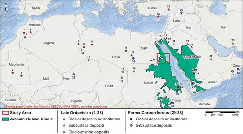
Late Ordovician glaciogenic features (i.e. deposits and landforms) have been reported from many locations in northern Africa, northern Arabia, southern Turkey and western Iran. In contrast, no Late Paleozoic glaciogenic features were reported from any of these areas with the exception of a single occurrence of a Late Paleozoic tillite in southern Western Desert of Egypt (Klitzsch Citation1983), the age of which was questioned by workers in the area (Issawi and Osman Citation1996). Both events (Early and Late Paleozoic glaciations) are represented in northern Central Africa (Niger and Chad), Horn of Africa (Eretria and Ethiopia) and southern Saudi Arabia, whereas Permo-Carboniferous glaciogenic deposits have been reported only from southern Arabia (i.e. Yemen and Oman) ( and references therein). The southwestward migration of the glaciogenic deposits during the Paleozoic glaciation events was in response to movement of the southern pole across Gondwana from NW Africa in the Late Ordovician to central Antarctica during the Permo-Carboniferous glaciation (Scotese and Barrett Citation1990; Torsvik and Cocks Citation2013). Throughout the postulated extent of the Ordovician glaciation, especially in northern Gondwana, a wide range of glacial deposits have been reported as well as subglacial landforms including mega-scale glacial lineation (MSGLs), tunnel valleys, and paleo-ice streams (Vaslet Citation1990; Armstrong et al. Citation2005; Denis et al. Citation2007; Le Heron et al. Citation2009; Ravier et al. Citation2015).
Figure 1. Location map showing the reported Early and Late Paleozoic glacial deposits and landforms (Late Ordovician: 1 to 28; Permo-Carboniferous: 29 to 38) from northern Gondwana. 1. (Ghienne and Deynoux Citation1998); 2. (Ghienne Citation2003); 3. (Le Heron Citation2007; Ravier et al. Citation2015); 4. (Le Heron and Craig Citation2008); 5. (Ghienne et al. Citation2007; Ravier et al. Citation2015); 6. (Lang et al. Citation2012); 7. (Le Heron et al. Citation2005); 8. (Le Heron et al. Citation2006); 9. ((Le Heron et al. Citation2004); 10. (Denis et al. Citation2007); 11. (Le Heron and Craig Citation2008); 12. (Klitzsch Citation1978; Issawi and Jux Citation1982; Issawi and Osman Citation1996); 13&14. (Semtner et al. Citation1994); 15 and 16. (Issawi and Jux Citation1982); 17. (Kumpulainen et al. Citation2006; Kumpulainen Citation2008); 18. (Kumpulainen Citation2008; Lewin et al. Citation2018); 19. (Abed et al. Citation1993; Turner et al. Citation2005); 20. (Tofaif et al. Citation2018); 21. (Vaslet et al. Citation1994; Michael et al. Citation2018); 22. (McClure Citation1978; Vaslet Citation1990; Aoudeh and Al-Hajri Citation1995); 23. (Vaslet Citation1990; Clark-Lowes Citation2005; Melvin Citation2018); 24. (Al-Husseini Citation2004; Al-ajmi et al. Citation2008; Keller et al. Citation2011); 25. (Ghavidel-syooki et al. Citation2011); 26, 27, and 28. (Monod et al. Citation2003; Ghienne et al. Citation2010); 29. (Lang et al. Citation1991); 30. (Le Heron Citation2018); 31. (Klitzsch Citation1983); 32. (Lewin et al. Citation2018); 33. (Bussert Citation2010, Citation2014; Lewin et al. Citation2018); 34. (Kruck and Thiele Citation1983; El-Nakhal Citation1984); 35. (Alsharhan et al. Citation1993; Al-Husseini Citation2004; Al-ajmi et al. Citation2008; Keller et al. Citation2011); 36. (Melvin and Sprague Citation2006). 37. (Martin et al. Citation2008; Heward and Penney Citation2014); 38. (Braakman et al. Citation1982; Al-Belushi et al. Citation1996).
In Egypt, the interpretation of the Paleozoic glaciation is controversial. Earlier detailed field studies documented Late Ordovician glacial diamictites in the Western Desert and fluvioglacial deposits in the North Eastern Desert and in the Sinai Peninsula (Beall and Squyres Citation1979; Issawi and Jux Citation1982; Semtner et al. Citation1994). However, a few regional studies dismissed the presence of the Ordovician glaciation in Egypt (Le Heron et al. Citation2005; Ghienne et al. Citation2007; Torsvik and Cocks Citation2013), while others considered these deposits to have been eroded from the Central Eastern Desert (CED) and the SED during the Cenozoic (Vaslet Citation1990). One possible explanation for these conflicting analyses is that the regional studies were based on information extracted from regional maps, the majority of which omitted the Paleozoic outcrops that were of limited areal extent and distribution. Records of the Permo-Carboniferous glaciation were reported only from the south Western Desert of Egypt (Klitzsch Citation1983), yet their assigned stratigraphic position and their ages were later challenged by field and topographic observations (Issawi and Osman Citation1996).
In this study, we report for the first time evidence for Paleozoic glaciation in the SED. Using remote sensing and field-based observations we identify glaciogenic deposits and exhumed subglacial kilometer-scale, streamlined features including megalineations (MLs) developed on the peneplained pavements of the Neoproterozoic basement complex. Although we cannot rule out a Permo-Carboniferous age for the SED glaciogenic deposits, we provide observations in favour of a Late Ordovician (Hirnantian) depositional age. We correlate the distribution of the SED glaciogenic deposits and linear features to those previously reported in other locations in the Sahara and in Arabia to examine the continuity of these features from Africa into Arabia. Our findings could potentially enhance the current understanding of the continuity of the Late Ordovician ice sheet along North Gondwana (from North Africa into Arabia) and the extension, dynamics, and intensity of the Early Paleozoic glaciation.
Data and methods
In the winter season of 2017, a regional mapping campaign was conducted by the senior author and his colleagues from Al-Azhar University aimed at gold exploration in the study area (area outlined by red box in ). Throughout the mapping project historical gold mining sites were identified, two of which were dug in diamictite deposits. In 2018, the previously identified two mine locations and an additional site (Wadi El-Naam) were targeted for detailed mapping and sampling, collection of field observations pertaining to the nature and distribution of glaciogenic landforms, deposits, and lithofacies. We then generated a GIS to host all relevant published (e.g. geologic maps) and generated data (i.e. field and remote sensing), to integrate observations extracted from these datasets, and to conduct spatial investigations and analyses. The GIS encompasses the following spatial datasets: (1) field observations, including (a) distribution of glacial diamictites at the contact of the Nubia Sandstone Formation with the basement complex in Wadi El-Naam area, (b) distribution of remnant glacial diamictites within paleo-depressions in the basement complex at Korbiai area, and (c) location of the meltwater outwash deposits in Betan area; (2) published data, including (a) 1:250,000 geologic map (EGSMA Citation1996), and (b) 1:500,000 (EGPC-Conoco Coral Citation1987); and (3) remote sensing data, including (a) Advanced Land Observing Satellite (ALOS) Phased Array L-band Synthetic Aperture Radar (PALSAR) data that was used for the delineation of large-scale morphological features (e.g. MLs), (b) multispectral images (bands 7, 5, and 3) extracted from Landsat 8 images for the validation of the radar-based MLs distribution, (c) high-resolution (spatial resolution: up to 30 cm) multispectral base map imagery available on the Arc GIS Online base map and Google Earth, where both datasets were used for the identification of small-scale glacial features (e.g. drumlin hills), and (d) ALOS PALSAR digital elevation model (DEM; spatial resolution: 12.5 m) used for 3D visualization and delineation of selected paleo valleys. Radar data were downloaded from the global PALSAR-2/PALSAR mosaic (spatial resolution: 25 m) that was generated from the Japanese L-band SAR images (JAXA Citation2014). All of the digital datasets were generated using ESRI ArcMap V. 10.6.1 software and were co-registered to a unified Universal Transverse Mercator (UTM) projection (zone 36N) and Datum (WGS-84) in a GIS environment. The GPlates 2.1 software (Gplates Citation2018) was used to generate a paleogeographic reconstruction (using the stereographic south polar projection) for the reported Late Ordovician glacial deposits and ice flow directions over the (1º x 1º) paleo-digital elevation model (PaleoDEM) (Scotese and Wright Citation2018).
Figure 2. Simplified geological map for the study area extracted from EGPC-Conoco Coral Citation1987; EGSMA Citation1996.
Geologic setting
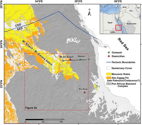
The SED is comprised of outcrops of the Neoproterozoic basement complex, the Paleozoic-Cretaceous Nubia Sandstone Formations, and Quaternary deposits (). The Neoproterozoic basement complex is part of the Arabian Nubian Shield (ANS), which formed by accretion of the intra-oceanic island arc, continental microplates, and oceanic plateaus during the closure of the Mozambique Ocean and the collision between east and west Gondwana (Gass Citation1981; Kröner et al. Citation1987; Stern Citation1994; Abdelsalam and Stern Citation1996; Johnson and Woldehaimanot Citation2003; Johnson et al. Citation2011). The ANS covers extensive areas (~1.5 x 10⁶ km2) on either sides of the Red Sea. The Neoproterozoic outcrops of the Nubian Shield extend across Egypt, Sudan, Eritrea, and Somalia, whereas those of the Arabian Shield crop out in Saudi Arabia, Jordan, and Yemen. The study area (~50,000 km2) occupies large sectors of the SED. East of the study area, Neoproterozoic rocks form rugged, high relief (up to 1978 m.a.m.s.l at G. Hamata; Said Citation1962), mountain chains along the western coastal plain of the Red Sea, whereas west of it, the outcrops are characterized by lower elevations (450 to 700 m.a.m.s.l) and smoother topography. North of the study area, the Paleozoic-Mesozoic Nubia Sandstone Formations crop out along a sedimentary basin (Wadi Kharit/Wadi Garara basin) that extends in a NW-SE-trending direction towards the Nile Valley ().
The Paleozoic nomenclature in Egypt is controversial; formation names are not well established, different names are given to the same formation, and sometimes the same name is assigned to more than one formation (Klitzsch Citation1986; Klitzsch and Squyres Citation1990; Issawi and Osman Citation1996; Khedr et al. Citation2010). In addition, assigned formation names could cover a wide temporal range and spatial distribution. For example, the term ‘Nubia Sandstone Formation’ encompasses Cambrian to Cretaceous clastic units that are ubiquitous in North Africa and Arabia. Attempts to abolish, modify (Pomeyrol Citation1968; Klitzsch and Squyres Citation1990), or precisely define (Issawi and Jux Citation1982) the well-established and widely used inadequate formation names have failed. The term ‘Nubia Sandstone Formation’ has been used for the past two centuries (Russegger Citation1837) and continues to be used today. We speculate that this is one of the main reasons that a number of regional studies concluded that the Late Ordovician glaciation event in North Africa and Arabia is absent in Egypt (Sutcliffe et al. Citation2000; Le Heron et al. Citation2005; Ghienne et al. Citation2007), a conclusion that is at odds with early field-based studies that documented Late Ordovician glacial tillite in the Western Desert and fluvioglacial deposits in the North Eastern Desert and Sinai (Beall and Squyres Citation1979; Issawi and Jux Citation1982).
Researchers working in the SED face additional difficulties. Published regional (1:250,000 to 500,000) maps (e.g. EGPC-Conoco Coral Citation1987; EGSMA Citation1996) consider the entire clastic succession, namely the Abu Aggag, Timsah, and Um Barmil Formations, above the basement complex as Upper Cretaceous in age, and in doing so, they ignore the earlier findings that report Paleozoic fossils (Devonian-Carboniferous) in the lower clastic unit (Abu Aggag Formation) in the SED from Wadi Kharit/Wadi Garara basin and east Aswan (Issawi and Jux Citation1982; Jux and Issawi Citation1983; Zaghloul et al. Citation1983; Issawi and Osman Citation1996; Khedr et al. Citation2010).
In an effort to address these complexities arising from the wide temporal range of ages assigned to the term ‘Nubia Sandstone Formation', Khedr et al. (Citation2010) classified the stratigraphic section in the Aswan area to a lower ‘Infra Nubia Group’ for the clastic succession from Cambrian to Late Jurassic, the ‘Nubia Group’ for the Late Jurassic to Maastrichtian successions, and the ‘Ultra Nubia Group’ for the Campanian to Paleocene deposits. For the same purpose, and because the Paleozoic glaciation deposits and landforms are the focus of this study, we use the terms ‘preglacial’ for the Cambrian-Ordovician deposits, including the Araba Formation, ‘glaciogenic’ for the Late Ordovician deposits, and ‘Post Glacial Nubia Sandstone Formation’ (PG-NSF) for the Paleozoic Nubia Devonian-Carboniferous Abu Aggag Formation and the overlying Mesozoic Nubia of Late Cretaceous Temsah and Um Barmil Formations. Throughout the text we provide evidence in support of the suggested classification.
Glaciogenic deposits
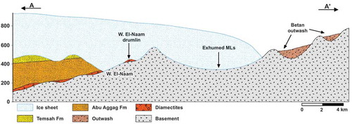
The glaciogenic deposits of the SED were apparently largely eroded during the uplift associated with the Red Sea opening in the Cenozoic that gave rise to the Red Sea Hills. We identified and report a few preserved outcrops that apparently escaped this erosional event. To the west of the Red Sea Hills, we describe remnant Paleozoic glacial deposits that are preserved within paleo-topographic lows in the Betan and Korbiai areas and as basal conglomeratic units (diamictite) below the PG-NSF in Wadi El-Naam ().
Wadi El-Naam
Wadi El-Naam clastic succession rests over the uneven basement surface and is represented by a 1–3 m thick paleosol horizon that is unconformably overlain by a massive diamictite deposit ()). The paleosol layer is reddish in colour with yellow to pale brown patches and consists of 60%–70% angular to sub-angular clasts (size: millimeters to centimeters) within a highly altered and oxidized clay matrix. All the clasts were derived from the Neoproterozoic basement. The paleosol layer separates the underlying Neoproterozoic basement rocks from the Phanerozoic clastic succession and plunges eastward under the Wadi Kharit/Wadi Garara basin ().
Figure 3. Field photographs for glacial diamictites in the SED from Wadi El-Naam (a, b, c, and d) and Korbiai (e, f, and g). (a) Glacial diamictites [Dmm] unconformably overlying a preglacial paleosol [S] of Cambrian-Ordovician age in Wadi El-Naam drumlin hill. (b) Thick deposits (~20 m) of massive boulder-rich diamictites. (c) Matrix supported, sub-angular to rounded clasts occasionally showing elongation along sub-horizontal axes. (d) Rotated clasts within the glaciotectonite layer at the base of glacial diamictites. (e) Unsorted boulder-rich diamictites [Dmm] overlying an uneven basement surface [B]. (f) Poorly sorted, well rounded to sub-angular, matrix supported diamictites. (g) Fining upward diamictite clasts, which could be indicative of an ice retreat depositional environment.
![Figure 3. Field photographs for glacial diamictites in the SED from Wadi El-Naam (a, b, c, and d) and Korbiai (e, f, and g). (a) Glacial diamictites [Dmm] unconformably overlying a preglacial paleosol [S] of Cambrian-Ordovician age in Wadi El-Naam drumlin hill. (b) Thick deposits (~20 m) of massive boulder-rich diamictites. (c) Matrix supported, sub-angular to rounded clasts occasionally showing elongation along sub-horizontal axes. (d) Rotated clasts within the glaciotectonite layer at the base of glacial diamictites. (e) Unsorted boulder-rich diamictites [Dmm] overlying an uneven basement surface [B]. (f) Poorly sorted, well rounded to sub-angular, matrix supported diamictites. (g) Fining upward diamictite clasts, which could be indicative of an ice retreat depositional environment.](/cms/asset/6dcdafa6-a31d-4383-a2c9-f99a137d84b0/tigr_a_1636416_f0003_c.jpg)
The overlying diamictite deposits crop out along a 20m high, ENE-trending hill ()) and separate the basement (east) from the PG-NSF (west) (). The diamictite is a massive, polymictic, unsorted, boulder rich, and matrix supported unit. The boulders vary from well-rounded to sub-angular, occasionally with sub-horizontal long axes ()). The boulders vary from few centimeters to a meter in diameter. A highly deformed, one meter thick, basal layer with rotated clasts is observed at the contact between the diamictite deposits and the underlying basement ()).
The paleosol layer and similar deposits across the ANS could have been produced throughout the long-lived peneplanation process of the ANS orogenic belt in the Cambrian and Ordovician periods. We interpret the paleosol layer as preglacial deposits that could be correlated with the Araba Formation paleosols in eastern Sinai (Issawi et al. Citation1999; Hassan et al. Citation2013) and eastern Aswan (Khedr et al. Citation2010); the overlying boulder rich, massive, matrix supported, diamictites are here interpreted as subglacial diamictites that were deposited during the Late Ordovician glaciation over northern Gondwana. The one meter thick basal deformed layer with rotated clasts could be indicative of near margin, subglacial, basal shear deformation.
Korbiai
The deposits in Korbiai area, form small (tens of meters on the side), remnant, isolated outcrops that unconformably overlie the basement rocks. They are composed of several meters (3–5 m; )), of poorly preserved, massive, unsorted, polymictic, boulder-rich diamictites with matrix support ()). The clasts size vary from few centimeters to nearly one meter in diameter. All the clasts are derived from the basement rocks. One of the outcrops shows clear upward fining of clasts ()).These deposits are poorly preserved, yet they can be correlated with the subglacial massive diamictites in Wadi El-Naam area. The outcrops with upward fining clasts could indicate ice retreat deposition conditions.
Betan
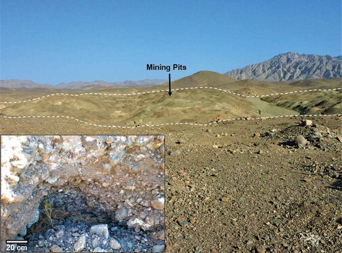
In the Betan area, some 25 km to the east of the Wadi El-Naam area, a diamictite deposit lies within the basement complex outcrop area and covers a wide and shallow depression (length: 1.5 km; width: 700 m; depth: <4 m). Several small ancient mining pits (dating from the Predynastic period up to the early Arab World; Klemm and Klemm Citation2013) targeting associated placer gold deposits were observed in the area (). The diamictite deposits in the Betan area are rounded to sub-rounded, moderately sorted with occasional well-defined horizontal bedding planes. Occasionally, the boulder clasts display elongation (long axes range from 10 to 20 cm in length) subparallel to bedding planes ().
Figure 4. Field photographs of outwash deposits in a wide plain (area: 0.5 km2) within the basement outcrop area in the Betan area, showing many ancient gold mining pits targeting glacially hosted placer gold deposits. Inset: An ancient pit showing moderately sorted, well rounded clasts with sub-horizontal bedding planes that could indicate deposition in a proximal ice marginal meltwater environment.
The texture (bedded, moderately-sorted, and well-rounded fabrics) of the deposits east of Wadi El-Naam subglacial diamictites and the presence of a wide depression in this area could suggest an ice frontal meltwater origin for these deposits. We suggest that the reported glacial deposits from Wadi El Naam, Korbiai and Betan show genetic facies changes from subglacial diamictites in Wadi El-Naam and Korbiai, to ice-proximal meltwater outwash deposits in Betan.
Subglacial streamlined features
Formation of subglacial streamlined landforms is a fundamental process that has been documented in the recent subglacial environments (Menzies Citation1979; Stokes et al. Citation2011; Hart et al. Citation2018). The presence of streamlined features in paleo-glaciers such as those described here are not only strong evidence for paleo-glacial events, but are also indicative of ice flow directions, ice velocities, and glacier types (Bussert Citation2010; Krabbendam et al. Citation2016; Eyles and Doughty Citation2016). In this section, we provide two additional lines of evidence for the advancement of Paleozoic ice sheet over the SED. These are well expressed MLs and isolated drumlins.
Megalineations (MLs)
Mapping of large-scale subglacial features such as MSGLs was facilitated by the release of Landsat images in the 1970s and 1980s, given the large contiguous areas covered by these scenes and their good spatial resolution (30–70 m; Boulton and Clark Citation1990; Clark Citation1993). Since then, a wide range of remote sensing datasets (e.g. ASTER, QuickBird, Google Earth imagery, WorldView-2, ERS 1, LiDAR, and UAV-captured imagery) have been used for identifying and delineating active and recent (e.g. Cenozoic glaciation) large-scale glacial features (Clark et al. Citation2000; Glasser et al. Citation2005; Smith et al. Citation2006; Ely et al. Citation2017; Chandler et al. Citation2018; Sookhan et al. Citation2018). Similarly, multispectral remote sensing images have been used to map exhumed MSGLs of the Early and Late Paleozoic glaciations in North Africa (Moreau et al. Citation2005; Le Heron and Craig Citation2008; Le Heron Citation2018).
The early usage of the term ‘MSGLs’ was to describe linear features developed on varying lithologies (Boulton and Clark Citation1990; Clark Citation1993). However, recently, the term was used exclusively to describe linear glacial features over soft sediments (mainly till) (e.g. Krabbendam and Bradwell Citation2011; Spagnolo et al. Citation2014) and MLs were used to describe kilometer-scale megagrooves and megaridges lineations over hard beds (Bradwell et al. Citation2008; Krabbendam et al. Citation2016). In this study, we use the term ‘MLs’ to describe the observed, kilometer-scale, subglacial lineations on the hard beds of the Neoproterozoic basement.
We used the ALOS PALSAR data together with optical datasets (Landsat 8 multispectral images) and digital topography (12.5 m ALOS DEM) to map MLs in the SED. The ALOS PALSAR is sensitive to roughness and has deep penetration capabilities (up to 2 m; Xiong et al. Citation2017) in hyper-arid conditions similar to those of the SED. The use of ALOS PALSAR data enables the differentiation of linear subparallel, ENE-WSW trending, basement megaridges with rough surfaces (high backscatter/bright) from intervening subparallel valleys (megagrooves) filled with sands and characterized by smooth surfaces (low backscatter/dark; ,)). Moreover, it enables mapping the extension of the megaridges and the intervening megagrooves that were covered under thin veneers of sediments. The overall radar-based distribution of ridges and grooves was corroborated with observations extracted from the multi-spectral Landsat 8 images and ALOS DEM in areas where coverage with wind-blown sands was minimal (,)). On the ALOS DEM images, the megaridges and megagrooves appear as topographically high (bright) and low (dark) areas respectively, and on the Landsat images, as low reflectance (dark) and high reflectance areas (bright), respectively. The megagrooves are filled with fine-grained sands and hence have a high reflectance compared to the megaridges that are generally composed of coarse-grained, low reflectance rocks (Sultan et al. Citation1987; Rivard et al. Citation1992; )).
Figure 5. Mapping of the MLs in the SED using ALOS PALSAR, multispectral Landsat 8, and ALOS DEM data. (a) ALOS PALSAR backscatter mosaic for the study area (left) and interpretation map showing the distribution of MLs (right). (b) Left: enlargement of the area covered by the blue boxes in Figure 5(a) showing ENE-WSW trending linear sub-parallel megaridges (bright) and intervening megagrooves (dark). Right: interpretation map showing the distribution of MLs (red lines), which indicate paleo-ice flow directions. (c) Landsat 8 multi-spectral image (RGB, Landsat bands 753) for the area covered by blue box in Figure 5(a) showing linear megaridges (dark) and intervening megagrooves (bright) and an interpretation map showing the distribution of MLs (red lines). (d) 3D view (vertical exaggeration: 6×) for the area covered by blue box in Figure 5(a) with the ALOS PALSAR data draped over the ALOS DEM showing the distribution of megaridges and intervening ENE-WSW oriented megagrooves.
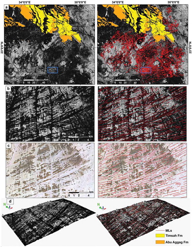
Inspection of the regional ALOS PALSAR mosaic for the study area () shows a previously unrecognized occurrence of MLs that covers large areas (length: 200 km; width: 100 km) of the SED. Within this area, sub-parallel megaridges and megagrooves (length: 2 to 40 km; width: 100 to 300 m; depth: up to to 30 m; separation: 0.4 to 2 km) trend in a ENE-WSW direction (). The dimensions of the SED MLs are consistent with those reported from Quaternary glaciations. (Bradwell et al. Citation2008; Krabbendam and Bradwell Citation2011; Krabbendam et al. Citation2016). The fact that the SED MLs do not follow any of the known tectonic trends of the SED suggests that they themselves are not tectonic in origin. This interpretation is further supported by the absence of evidence for extensive brittle and/or ductile, ENE-WSW trending, overprinting (e.g. faults, foliation, lineations, etc) within the areas where the MLs were identified in the SED, had the overprint been tectonic in nature. The known SED tectonic trends consist of: (1) the NW-SE trend related to the Red Sea opening (Oligo-Miocene; Bosworth et al. Citation2005; Almalki et al. Citation2015) and the earlier (550–450 Ma) Najd Fault System (Stern Citation1985; Sultan et al. Citation1988); (2) the N-S trend of the Hamisana shear zone (Miller and Dixon Citation1992; Abdelsalam and Stern Citation1996; de Wall et al. Citation2001); and (3) the WNW-ESE Allaqi suture zone trend (Abdelsalam et al. Citation2003; Zoheir and Klemm Citation2007; Abdeen and Abdelghaffar Citation2011). The SED MLs are well preserved over peneplained Neoproterozoic outcrops in the central SED, gradually fading towards the Red Sea Hills, and none are recognized within the PG-NSF outcrops. This observation together with the reported glacial diamictites in this study at the contact between the Neoproterozoic basement and Paleozoic Nubia Formation (Devonian-Carboniferous) favour a glacial origin for these linear features during the Late Ordovician (Hirnantian) glaciation period. The well preserved exposures of the MLs in the central parts of the SED and their absence over the Red Sea Hills suggest they were exhumed and eroded during the Red Sea opening and associated uplift some 25 Ma ago.
Drumlins
As is the case with the MLs, drumlins are considered significant indicators of paleoglacial events and ice flow directions (Boulton and Clark Citation1990; Kleman and Borgström Citation1996; Knight and McCabe Citation1997; Hart Citation1999; Stokes et al. Citation2013). In general, in older glaciations, the preservation of drumlin morphology is not expected to be as good as that for MLs, and thus their use as indicators for old glacial events should be treated with caution and only if additional indicators are present. In North Africa, drumlins have been reported from the Late Paleozoic glaciation but not from the Late Ordovician glaciation (Le Heron Citation2018).
Three elongated oval-shaped hills, here interpreted as exhumed drumlins are present at the contact between the PG-NSF and the Neoproterozoic basement. They are 200–300 m in length, 100–150 m in width, 15–25 m in height, and are approximately 100 m apart ()). They are elongated in an ENE-WSW direction, the direction of the identified MLs.
Figure 6. Wadi El-Naam drumlin hills. (a) Arc GIS base map image for the drumlin hills of Wadi El-Naam between the basement (east) and the PG-NSF (west). (b) Cross section along the AAʹ line.
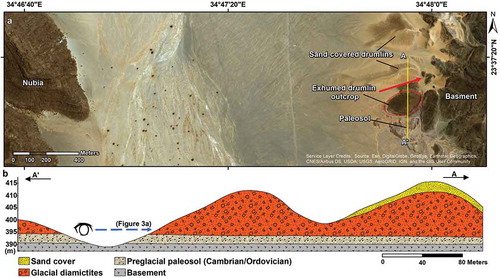
The southern drumlin hill is completely exposed and is composed of a 1–3 m thick paleosol overlain by 18–20 m of boulder-rich diamictites ()). The other two drumlins are covered by a sand veneer sourced from the PG-NSF (). The spatial distribution of the exposed and inferred sand-covered drumlins could indicate the extension of these glacial deposits beneath the PG-NSF. The presence of these drumlins with the MLs suggest that they represent erosional features (Stokes et al. Citation2013; Eyles et al. Citation2016; Sookhan et al. Citation2018).
Reconstruction of the Paleozoic glaciation in the SED
We reported evidence for the distribution of a broad field of MLs over peneplained Neoproterozoic outcrops in the central sections of the SED and a limited number of glaciogenic deposit exposures (3 locations) to the east of the MLs field. The distribution of the MLs and the spatial variations of glaciogenic facies in the identified glacial system provide insights into the paleo-geologic setting of the Paleozoic glaciation in the SED.
A schematic cross-section was generated subparallel to the postulated ice flow directions and passing through the identified glaciogenic outcrops (). The advocated ice flow directions are subparallel to the identified MLs trends. The profile passes through Wadi El-Naam (west) and Betan (east) (). Distinctive glaciogenic facies variations were recognized along the constructed cross-section. The Betan outwash deposits located to the east of the subglacial diamictites of Wadi El-Naam () could indicate a paleo-ice margin somewhere between these two outcrops. The MLs trends in combination with the suggested ice margin between Wadi El-Naam and Betan are consistent with west-to-east ice sheet movement and can account for the observed change of glaciogenic deposits from subglacial facies in Wadi El-Naam in the west to meltwater deposits in Betan to the east.
Figure 7. Schematic west-east cross section along A-Aʹ profile (see location in ) showing glacial deposits at the base of the Nubia Sandstone Formation and within topographic lows in the basement, the mapped MLs, and a facies change from subglacial diamictites (Wadi El-Naam) to meltwater outwash (Betan), and a possible location for the ice margin between both areas.
Discussion
Evidences for Late Ordovician age
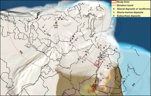
Inspection of the remote sensing datasets and compilation of previously published chronometric and biostratigraphic data are consistent with a Late Ordovician age of the reported glaciogenic features. Evidences include: (1) the MLs trends in the SED align along their strike and projected extension with the Late Ordovician tunnel valleys and striation trends in northwest Saudi Arabia (Vaslet Citation1990; Clark-Lowes Citation2005) (); (2) zircon and sphene fission track data from the SED indicate that the temperatures predating the onset of cooling and erosion reached approximately 300°C and that the Neoproterozoic rocks were covered by 5–15 km of overburden between the Late Devonian and the Oligocene (Bojar et al. Citation2002). These findings make it highly unlikely for the presumed Late Paleozoic ice sheet to have had direct contact with the Neoproterozoic rocks where MLs were recognized; (3) the reported Devonian ichnofossils such as Bifungites Arthrophycus, Diplocraterion and Asterichnus and Carboniferous Calamites and lepidodendroids (Knorria) from the postglacial Abu Aggag Formation in the Wadi Kharit/Wadi Garara basin and East Aswan area (Jux and Issawi Citation1983; Zaghloul et al. Citation1983; Issawi and Osman Citation1996; Khedr et al. Citation2010) argue against the previously suggested Cretaceous age for Abu Aggag Formation (Klitzsch Citation1986; EGPC-Conoco Coral Citation1987; Klitzsch and Squyres Citation1990; EGSMA Citation1996), a suggestion that was based on stratigraphic observations, but lacks faunal evidence; and (4) the Late Paleozoic glaciation has never been reported from North Africa and/or north Arabia except for the south Western Desert of Egypt where glacial tillites were reported (Klitzsch Citation1983). However, the ages and glacial affinities of these tillites were debated (Issawi and Jux Citation1982; Issawi and Osman Citation1996; Le Heron et al. Citation2009) and their distribution was excluded from all the recent reconstructions of the Late Paleozoic glaciation (Fielding et al. Citation2008; Isbell et al. Citation2012; Wopfner Citation2013; Lewin et al. Citation2018), including the Late Paleozoic ice cap in Chad and Niger (Le Heron Citation2018). These evidences are consistent with a Late Ordovician age for the glaciogenic deposits in the SED, yet they do not completely rule out contributions from younger Paleozoic glaciations cannot be dismissed; additional thermochronometric studies are needed to constrain the age and provenance of the SED glacial deposits.
Figure 8. Paleo-reconstruction map (445 Ma) for the reported deposits and striation trends (1 to 28; refer to caption of ) from the northern Gondwana Late Ordovician ice sheet (from ) plotted over the Gondwana paleogeographic base map (Scotese Citation2016; Scotese and Wright Citation2018) using the stereographic south polar projection.
Regional contributions for the MLs in the reconstruction of the Late Ordovician ice sheet
Despite the apparent presence of significant paleo-glacial features over the SED and possibly over additional peneplained Neoproterozoic outcrops within the ANS, these features were not recognized by researchers in the area. For example, many of the paleo-glaciological maps mark all the ANS as an eroded area that is not expected to preserve any paleo-geomorphological features (Vaslet Citation1990; Le Heron et al. Citation2005). This could be related to a prevailing opinion that today’s landscape in the Eastern Desert and the ANS is the product of Cenozoic geological and climatic processes, namely the Red Sea-related rifting and uplift tectonics and the alternating wet and dry periods during the Pleistocene (Abotalib et al. Citation2016). The shoulders of the rift along the Red Sea, Gulf of Suez, and the Dead Sea transform fault were elevated by as much as 4 km, exposing the crystalline basement and the overlying thick (up to 2.5 km) sedimentary successions to extensive erosion (Bosworth et al. Citation2005; Almalki et al. Citation2015).
There seems to be a consensus that pre-Jurassic (Gondwana breakup) erosional surfaces are rare in Afro-Arabia, and if preserved, they would have been exhumed from beneath a sedimentary cover (Partridge and Maud Citation1987; Burke and Gunnell Citation2008). This model explains the existence of Late Ordovician subglacial erosional and depositional features and landscapes in the study area. We attribute the preservation of the identified glacial deposits and features (MLs, drumlins, and diamictites) in the SED to their burial under the overlying Nubian sequences since the Devonian Period (Abu Aggag Formation) and their exhumation during the Red Sea opening and associated uplift. The uplift of the basement complex gave rise to the Red Sea Hills and eroded away basement rocks and much of the overlying sedimentary sequences including the glacial deposits. The identified glacial features were locally exhumed where the PG-NSF sequences were eroded away, exposing the underlying glacial deposits and features. This apparently occurred in the remnant diamictite units deposited within paleo-depressions in the basement (e.g. Betan and Korbiai), as drumlins at the contact between PG-NSF and the uplifted basement (e.g. Wadi El-Naam), and as MLs over the peneplained basement, away from, but proximal to, the Red Sea Hills.
Despite the fact that many well-preserved striated surfaces, MSGLs, and tunnel valleys from Paleozoic sedimentary outcrops proximal to the Neoproterozoic ANS basement were cited in support of Early and Late Paleozoic glaciations in Africa and Arabia (Clark-Lowes Citation2005; Moreau et al. Citation2005; Ghienne et al. Citation2007; Le Heron and Craig Citation2008; Le Heron Citation2018; Tofaif et al. Citation2018), none have been identified from the basement itself. The Late Paleozoic glacially, striated pavements in Ethiopia (Bussert Citation2010) are the only exceptions. Our findings suggest that glacial features similar to the ones reported in this study may have gone undetected in the ANS and additional paleo-geomorphological investigations along the exhumed Neoproterozoic ANS are recommended.
Implications
The reported glacial deposits and subglacial landforms in the SED have paleo-glaciological significance. Identifying MLs and glacial deposits in the SED is important for deciphering the Late Ordovician ice sheet occurrence, intensity, dynamics, and continuity across Africa and Arabia. It will also assist in developing comprehensive reconstructions of the ice sheet history. This research adds a previously unrecognized occurrence for the Late Ordovician glaciation in the SED, an apparently significant missing part of the jigsaw puzzle of the Late Ordovician glaciation. The inferred ice flow directions in the SED of Egypt are consistent with the trends of tunnel valleys and striations within these valleys in Saudi Arabia (; Vaslet Citation1990; Clark-Lowes Citation2005). This observation further supports the previously hypothesized connection of the northern Gondwana ice sheet in the Sahara, Egypt, and Saudi Arabia (Vaslet Citation1990; Ghienne et al. Citation2007; Le Heron et al. Citation2009). Our findings in the SED of Egypt could also assist in addressing one of the unresolved questions pertaining to the number of cycles of the Late Ordovician glaciation. Four cycles of ice advances/retreats were reported from eastern Libya (Le Heron and Craig Citation2008), but only two from Saudi Arabia (Vaslet Citation1990; Tofaif et al. Citation2018). The identified ice margin in the SED suggests that at least one of the four ice sheet advances did not reach Arabia. This interpretation is consistent with the presence of three facies of glacial deposits within the tunnel valleys of Saudi Arabia (Clark-Lowes Citation2005), one of which is proglacial and glaciomarine in origin and is probably related to the SED ice margin.
The majority of the identified paleo-ice streams are confined to the Saharan ice sheet (western part of the northern Gondwana ice sheet; Moreau et al. Citation2005; Le Heron and Craig Citation2008; Ravier et al. Citation2015); however, the presence of ENE-WSW trending MLs and drumlins in the SED and tunnel valleys along their projected extension in Saudi Arabia support models (Stokes and Clark Citation1999; Winsborrow et al. Citation2010) that advocate the presence of paleo-ice stream in the eastern part of the northern Gondwana. Further studies will be needed to delineate the suggested paleo-ice stream.
The reported glacial deposits and subglacial landforms from the SED have economic significance as well. Wet-based glacial deposits, such as those reported for the SED, could potentially form significant mineral placer deposits by glacial meltwater (Eyles Citation1995; Eyles and De Broekert Citation2001); ice sheets have to have had advanced over rich mineralized terrains, which is the case with the ANS. The glaciogenic deposits and de-glaciated organically enriched shales (hot shales) can act as reservoir and source rocks, respectively (Husseini Citation1990; Bell and Spaak Citation2007; Le Heron et al. Citation2009; Huuse et al. Citation2012). Thus, the south Western Desert, northern Sudan, and the structurally controlled Nubia basins in the Eastern Deserts could be potential targets for Early Paleozoic reservoirs as extensions of the known Paleozoic reservoirs in Algeria, Libya, North Western Desert and Saudi Arabia (Le Heron et al. Citation2009; Huuse et al. Citation2012; Bosworth et al. Citation2015).
Summary
Exhumed subglacial paleo-landscapes and glaciogenic deposits of the Late Ordovician glaciation over the northern Gondwana continent were reported here for the first time from the SED of Egypt. The glaciogenic deposits unconformably overlie the Neoproterozoic basement rocks and are overlain by the PG-NSF. Most of these glacial deposits were largely eroded away during the Tertiary uplift associated with the Red Sea opening, except for those basal units beneath the PG-NSF, which now crop out as remnant isolated paleo-valley fillings within the basement complex (e.g. Betan) and at its contact with the overlying early Paleozoic sequences (e.g. Wadi El-Naam). Two main glaciogenic facies deposits were recognized in three sites: (1) massive, polymictic, poorly sorted, matrix-supported, boulder-rich diamictites in Wadi El-Naam and Korbiai, and (2) moderately sorted, discontinuously bedded meltwater outwash deposits in Betan area.
Inspection of radar backscatter images, Landsat 8 multispectral images, and digital topography revealed previously unrecognized MLs covering large areas (length: 200 km; width: 100 km) in the SED. The MLs appear as sub-parallel, ENE-WSW trending megaridges and megagrooves (length: 2 to 40 km; width: 100 to 300 m; depths up to 30 m); their trends are consistent with those reported for the Late Ordovician tunnel valleys in Saudi Arabia and for striations within those valleys (Vaslet Citation1990; Clark-Lowes Citation2005). Three ENE-WSW trending, oval, elongated hills, here interpreted as drumlins (length: 200–300 m, width: 100–150 m, height: 15–25 m) were exhumed in Wadi El-Naam at the contact between the PG-NSF and the Neoproterozoic basement. An ice margin was inferred from the observed west to east variations in glaciogenic facies: subglacial diamictites in Wadi El-Naam, and meltwater outwash deposits in Betan.
Acknowledgments
The authors thank Professor John Menzies for his contribution in identifying and interpreting the paleosol layer, and Mr. Eid Nour, Mr. Nasser Awad, and Shiekh Sir El-Khatam (the head of the Ababda tribe) for facilitating fieldwork. We extend our gratitude to the IGR Reviewers (William Bosworth and an anonymous reviewer) for their constructive comments that significantly improved this work, along with Robert Stern for his suggestions and for handling the manuscript.
Disclosure statement
No potential conflict of interest was reported by the authors.
Additional information
Funding
References
- Abdeen, M.M., and Abdelghaffar, A.A., 2011, Syn- and post-accretionary structures in the neoproterozoic central allaqi-heiani suture zone, Southeastern Egypt: Precambrian Research, v. 185, p. 95–108. doi:10.1016/j.precamres.2010.12.006
- Abdelsalam, M.G., Abdeen, M.M., Dowaidar, H.M., Stern, R.J., and Abdelghaffar, A.A., 2003, Structural evolution of the Neoproterozoic Western Allaqi – Heiani suture, southeastern Egypt: Precambrian Research, v. 124, p. 87–104. doi:10.1016/S0301-9268(03)00080-9
- Abdelsalam, M.G., and Stern, R.J., 1996, Sutures and shear zones in the Arabian-Nubian Shield: Journal of African Earth Sciences, v. 23, p. 289–310. doi:10.1016/S0899-5362(97)00003-1
- Abed, A.M., Makhlouf, I.M., Amireh, B.S., and Khalil, B., 1993, Upper Ordovician glacial deposits in southern Jordan: Episodes, v. 16, p. 316–328
- Abotalib, A.Z., Sultan, M., and Elkadiri, R., 2016, Groundwater processes in Saharan Africa: Implications for landscape evolution in arid environments: Earth-Science Reviews, v. 156, p. 108–136. doi:10.1016/J.EARSCIREV.2016.03.004
- Al-ajmi, H.F., Keller, M., Hinderer, M., and Rausch, R., 2008, New insights into the facies distribution of the Wajid sandstone in its western outcrop area and implication on reservoir properties, in The 3rd International Conference on Water Resources and Arid Environments, Riyadh, Saudi Arabia, p. 1–13.
- Al-Belushi, J.D., Glennie, K.W., and Williams, B.P.J., 1996, A new hypothesis for origin of its Glaciation: Geoarabia, v. 1, p. 389–404
- Al-Husseini, M., 2004, Pre-Unayzah unconformity, Saudi Arabia, in Carboniferous, Permian and Early Triassic Arabian Stratigraphy, Manama, GeoArabia, p. 15–59.
- Almalki, K.A., Betts, P.G., and Ailleres, L., 2015, The Red Sea – 50 years of geological and geophysical research: Earth-Science Reviews, v. 147, p. 109–140. doi:10.1016/J.EARSCIREV.2015.05.002
- Alsharhan, A.S., Nairn, A.E.M., and Mohammed, A.A., 1993, Late Palaeozoic glacial sediments of the southern Arabian Peninsula: Their lithofacies and hydrocarbon potential: Marine and Petroleum Geology, v. 10, p. 71–78. doi:10.1016/0264-8172(93)90101-W
- Aoudeh, S.M., and Al-Hajri, S.A., 1995, Regional distribution and chronostratigraphy of the qusaiba member of the Qalibah formation in the Nafud Basin: Northwestern Saudi Arabia: AAPG Bulletin, v. 79. doi:10.1306/8D2B2303-171E-11D7-8645000102C1865D
- Armstrong, H.A., Turner, B.R., Makhlouf, I.M., Weedon, G.P., Williams, M., Al, A., and Abu, A., 2005, Origin, sequence stratigraphy and depositional environment of an upper Ordovician (Hirnantian) deglacial black shale, Jordan: Palaeogeography, Palaeoclimatology, Palaeoecology, v. 220, p. 273–289. doi:10.1016/j.palaeo.2005.01.007
- Beall, A.O., and Squyres, C.H., 1979, Modern exploration strategy in frontier areas, case history from Upper Egypt: AAPG Bulletin, v. 63, p. 416
- Bell, A., and Spaak, P., 2007, Gondwanan glacial events and their influence on petroleum systems in Arabia * By: AAPG International Conference and Exhibition, Perth, Australia, v. 30047, p. 1–4, http://www.searchanddiscovery.com/documents/2007/07004bell/.
- Bojar, A.V., Fritz, H., Kargl, S., and Unzog, W., 2002, Phanerozoic tectonothermal history of the Arabian-Nubian shield in the Eastern Desert of Egypt: Evidence from fission track and paleostress data: Journal of African Earth Sciences, v. 34, p. 191–202. doi:10.1016/S0899-5362(02)00018-0
- Bosworth, W., Abrams, M.A., Drummond, M., and Thompson, M., 2015, Jurassic rift initiation source rock in the Western Desert, Egypt—relevance to exploration in other continental rift systems, in P.J., Coleman, J., Rosen, N.C., Brown, D.E., Roberts-Ashby, T., Kahn, P., and Rowan, M.., eds., Petroleum Systems in “rift” basins, Gulf Coast Section SEPM, p. 615–650, 10.5724/15.34.0615.
- Bosworth, W., Huchon, P., and McClay, K., 2005, The red sea and gulf of aden basins: Journal of African Earth Sciences, v. 43, p. 334–378. doi:10.1016/J.JAFREARSCI.2005.07.020
- Boulton, G.S., and Clark, C.D., 1990, A highly mobile Laurentide ice sheet revealed by satellite images of glacial lineations: Nature, v. 346, p. 813–817. doi:10.1038/346813a0
- Braakman, J.H., Levell, B.K., Martin, J.H., Potter, T.L., and Van Vliet, A., 1982, Late Palaeozoic Gondwana glaciation in Oman: Nature, v. 299, p. 48–50. doi:10.1038/299048a0
- Bradwell, T., Stoker, M., and Krabbendam, M., 2008, Megagrooves and streamlined bedrock in NW Scotland: The role of ice streams in landscape evolution: Geomorphology, v. 97, p. 135–156. doi:10.1016/j.geomorph.2007.02.040
- Brenchley, P.J., Marshall, J.D., Carden, G.A.F., Robertson, D.B.R., Long, D.G.F., Meidla, T., Hints, L., and Anderson, T.F., 1994, Bathymetric and isotopic evidence for the short-lived Late Ordovician glaciation in a greenhouse period: Geology, v. 22, p. 295–2598.
- Burke, K., and Gunnell, Y., 2008, The African Erosion Surface: A Continental-Scale Synthesis of Geomorphology, Tectonics, and Environmental Change over the Past 180 Million Years, in Burke, K. and Gunnell, Y. eds., The African Erosion Surface: A Continental-Scale Synthesis of Geomorphology, Tectonics, and Environmental Change over the Past 180 Million Years, Geological Society of America, p. 1–66, doi:10.1130/2008.1201.
- Bussert, R., 2010, Exhumed erosional landforms of the Late Palaeozoic glaciation in northern Ethiopia: Indicators of ice-flow direction, palaeolandscape and regional ice dynamics: Gondwana Research, v. 18, p. 356–369. doi:10.1016/j.gr.2009.10.009
- Bussert, R., 2014, Depositional environments during the Late Palaeozoic ice age (LPIA) in northern Ethiopia, NE Africa: Journal of African Earth Sciences, v. 99, p. 386–407. doi:10.1016/j.jafrearsci.2014.04.005
- Chandler, B.M.P., Lovell, H., Boston, C.M., Lukas, S., Barr, I.D., Benediktsson, Í.Ö., Benn, D.I., Clark, C.D., Darvill, C.M., Evans, D.J.A., Ewertowski, M.W., Loibl, D., Margold, M., Otto, J.-C., Roberts, D.H., Stokes, C.R., Storrar, R.D., and Stroeven, A.P., 2018, Glacial geomorphological mapping: A review of approaches and frameworks for best practice: Earth-Science Reviews, v. 185, p. 806–846. doi:10.1016/j.earscirev.2018.07.015
- Clark, C.D., 1993, Mega-scale glacial lineations and cross-cutting ice-flow landforms: Earth Surface Processes and Landforms, v. 18, p. 1–29. doi:10.1002/(ISSN)1096-9837
- Clark, C.D., Knight, J.K., and Gray, J.T., 2000, Geomorphological reconstruction of the labrador sector of the laurentide ice sheet: Quaternary Science Reviews, v. 19, p. 1343–1366. doi:10.1016/S0277-3791(99)00098-0
- Clark-Lowes, D.D., 2005, Arabian glacial deposits: recognition of palaeovalleys within the Upper Ordovician Sarah Formation, Al Qasim district, Saudi Arabia: Proceedings of the Geologists’ Association, v. 116, p. 331–347, doi:10.1016/S0016-7878(05)80051-3.
- EGPC-Conoco Coral, 1987, Egyptian general petroleum corporation-conoco coral, geological map of Egypt, scale 1:500,000: Geological Survey of Egypt, Cairo, Egypt.
- de Wall, H., Greiling, R.O., and Sadek, M.F., 2001, Post-collisional shortening in the late Pan-African Hamisana high strain zone, SE Egypt: Field and magnetic fabric evidence: Precambrian Research, v. 107, p. 179–194. doi:10.1016/S0301-9268(00)00141-8
- Denis, M., Buoncristiani, J.-F., Konaté, M., Ghienne, J.-F., and Guiraud, M., 2007, Hirnantian glacial and deglacial record in SW Djado Basin (NE Niger).: Geodinamica Acta, v. 20, p. 177–195. doi:10.3166/ga.20.177-195
- EGSMA, 1996, Geological map of Jabal Hada’b Quadrangle, Egypt: Scale 1:250,000: Geological Survey of Egypt.
- El-Nakhal, H.A., 1984, Possible Late Palaeozoic glaciation in the central parts of the Yemen Arab Republic (Kohlan Group).: Journal of Glaciology, v. 30, p. 126–128. doi:10.1017/S0022143000008595
- Ely, J.C., Graham, C., Barr, I.D., Rea, B.R., Spagnolo, M., and Evans, J., 2017, Using UAV acquired photography and structure from motion techniques for studying glacier landforms: Application to the glacial flutes at Isfallsglaciären: Earth Surface Processes and Landforms, v. 42, p. 877–888. doi:10.1002/esp.4044
- Eyles, N., 1993, Earth’s glacial record and its tectonic setting: Earth Science Reviews, v. 35, p. 1–248. doi:10.1016/0012-8252(93)90002-O
- Eyles, N., 1995, Characteristics and origin of coarse gold in Late Pleistocene sediments of the Cariboo placer mining district, British Columbia, Canada: Sedimentary Geology, v. 95, p. 69–95. doi:10.1016/0037-0738(94)00101-Y
- Eyles, N., 2008, Glacio-epochs and the supercontinent cycle after ∼ 3.0 Ga: Tectonic boundary conditions for glaciation: Palaeogeography, Palaeoclimatology, Palaeoecology, v. 258, p. 89–129. doi:10.1016/j.palaeo.2007.09.021
- Eyles, N., and De Broekert, P., 2001, Glacial tunnel valleys in the eastern goldfields of Western Australia cut below the late paleozoic pilbara ice sheet: Palaeogeography, Palaeoclimatology, Palaeoecology, v. 171, p. 29–40. doi:10.1016/S0031-0182(01)00265-6
- Eyles, N., and Doughty, M., 2016, Glacially-streamlined hard and soft beds of the paleo- Ontario ice stream in Southern Ontario and New York state: Sedimentary Geology, v. 338, p. 51–71. doi:10.1016/j.sedgeo.2016.01.019
- Eyles, N., Mory, A.J., and Eyles, C.H., 2006, 50-million-year-long record of glacial to postglacial marine environments preserved in a Carboniferous-Lower Permian Graben, Northern Perth Basin, Western Australia: Journal of Sedimentary Research, v. 76, p. 618–632. doi:10.2110/jsr.2006.047
- Eyles, N., Putkinen, N., Sookhan, S., and Arbelaez-Moreno, L., 2016, Erosional origin of drumlins and megaridges: Sedimentary Geology, v. 338, p. 2–23. doi:10.1016/j.sedgeo.2016.01.006
- Fielding, C.R., Frank, T.D., and Isbell, J.L., 2008, The late Paleozoic ice age—A review of current understanding and synthesis of global climate patterns, in Special Paper 441: Resolving the Late Paleozoic Ice Age in Time and Space, Geological Society of America, v. 2441, p. 343–354, 10.1130/2008.244124.
- Finnegan, S., Bergmann, K., Eiler, J.M., Jones, D.S., Fike, D.A., Eisenman, I., Hughes, N.C., Tripati, A.K., and Fischer, W.W., 2011, The magnitude and duration of late Ordovician-early Silurian glaciation: Science, v. 331, p. 903–906. doi:10.1126/science.1200803
- Gass, I.G., 1981, Pan-African (Upper Proterozoic) plate Tectonics of the Arabian—Nubian Shield: Developments in Precambrian Geology, v. 4, p. 387–405. doi:10.1016/S0166-2635(08)70020-3
- Ghavidel-syooki, M., Álvaro, J.J., Popov, L., Pour, M.G., Ehsani, M.H., and Suyarkova, A., 2011, Stratigraphic evidence for the hirnantian (latest ordovician) glaciation in the zagros mountains, Iran: Palaeogeography, Palaeoclimatology, Palaeoecology, v. 307, p. 1–16. doi:10.1016/j.palaeo.2011.04.011
- Ghienne, J.-F., 2003, Late Ordovician sedimentary environments, glacial cycles, and post-glacial transgression in the Taoudeni Basin, West Africa: Palaeogeography, Palaeoclimatology, Palaeoecology, v. 189, p. 117–145
- Ghienne, J.F., and Deynoux, M., 1998, Large-scale channel fill structures in Late Ordovician glacial deposits in Mauritania, western Sahara: Sedimentary Geology, v. 119, p. 141–159. doi:10.1016/S0037-0738(98)00045-1
- Ghienne, J.-F., Le Heron, D.P., Moreau, J., Denis, M., and Deynoux, M., 2007, The late ordovician glacial sedimentary system of the North Gondwana Platform: Glacial Sedimentary Processes and Products, p. 295–319. doi:10.1002/9781444304435.ch17
- Ghienne, J.F., Monod, O., Kozlu, H., and Dean, W.T., 2010, Cambrian-Ordovician depositional sequences in the Middle East: A perspective from Turkey: Earth-Science Reviews, v. 101, p. 101–146. doi:10.1016/j.earscirev.2010.04.004
- Glasser, N.F., Jansson, K.N., Harrison, S., and Rivera, A., 2005, Geomorphological evidence for variations of the North Patagonian Icefield during the Holocene: Geomorphology, v. 71, p. 263–277. doi:10.1016/j.geomorph.2005.02.003
- Gplates, 2018, GPlates 2.1:, https://www.gplates.org/.
- Hart, J.K., 1999, Identifying fast ice flow from landform assemblages in the geological record: A discussion: Annals of Glaciology, v. 28, p. 59–66. doi:10.3189/172756499781821887
- Hart, J.K., Clayton, A.I., Martinez, K., and Robson, B.A., 2018, Erosional and depositional subglacial streamlining processes at Skálafellsjökull, Iceland: An analogue for a new bedform continuum model: Gff, v. 140, p. 153–169. doi:10.1080/11035897.2018.1477830
- Hassan, M.M., El-Gohary, A.M., and Akarish, A.I.M., 2013, Prelimenary record of Proterozoic-Phanerozoic palaeo-placer gold in Gebel Ghazalani Area: Chemo-stratigraphic evidence closing debate about Paleozoic sedimentation sequence: East Sinai, Egypt: Egyptian Journal of Geology, v. 57, p. 355–363
- Heward, A.P., and Penney, R.A., 2014, Al Khlata glacial deposits in the Oman Mountains and their implications: Geological Society, London, Special Publications, v. 392, p. 279–301. doi:10.1144/SP392.15
- Husseini, M.I., 1990, The cambro‐ordovician Arabian and adjoining plates: A Glacio‐Eustatic Model: Journal of Petroleum Geology, v. 13, p. 267–288. doi:10.1111/j.1747-5457.1990.tb00847.x
- Huuse, M., Le Heron, D.P., Dixon, R., and Redfern, J., 2012, Glaciogenic reservoirs and hydrocarbon systems : An introduction: Geological Society of London, Special Publications, v. 368, p. 1–28. doi:10.1144/SP368.19
- Isbell, J.L., Henry, L.C., Gulbranson, E.L., Limarino, C.O., Fraiser, M.L., Koch, Z.J., Ciccioli, P.L., and Dineen, A.A., 2012, Glacial paradoxes during the late Paleozoic ice age: Evaluating the equilibrium line altitude as a control on glaciation: Gondwana Research, v. 22, p. 1–19. doi:10.1016/j.gr.2011.11.005
- Issawi, B., El-Hinnawi, M., Francis, M., and Mazhar, A., 1999, The Phanerozoic geology of Egypt : A geodynamic approach: Cairo, Egyptian Geological Survey, 462 p
- Issawi, B., and Jux, U., 1982, Contributions to the stratigraphy of the Paleozoic Rocks in Egypt: Geological Survey of Egypt, Cairo, Egypt, 1–28 p. Cairo, Egypt.
- Issawi, B., and Osman, R.A., 1996, The sandstone enigma of south Egypt: Third Int. Conf, Cairo University, p. 359–380.
- JAXA, 2014, New global 25m-resolution PALSAR mosaic and forest/non-forest map (2007-2010): - version 1: https://www.eorc.jaxa.jp/ALOS/en/palsar_fnf/fnf_index20140116.htm (accesseed 16 January 2014)
- Johnson, P.R., Andresen, A., Collins, A.S., Fowler, A.R., Fritz, H., Ghebreab, W., Kusky, T., and Stern, R.J., 2011, Late Cryogenian–Ediacaran history of the Arabian–Nubian Shield: A review of depositional, plutonic, structural, and tectonic events in the closing stages of the northern East African Orogen: Journal of African Earth Sciences, v. 61, p. 167–232. doi:10.1016/J.JAFREARSCI.2011.07.003
- Johnson, P.R., and Woldehaimanot, B., 2003, Development of the Arabian-Nubian Shield: Perspectives on accretion and deformation in the northern East African Orogen and the assembly of Gondwana: Geological Society, London, Special Publications, v. 206, p. 289–325. doi:10.1144/GSL.SP.2003.206.01.15
- Jux, U., and Issawi, B., 1983, Cratonic Sedimentation in Egypt During the Paleozoic: Annals of the Geological Survey of Egypt, v. XIII, p. 223–245
- Keller, M., Hinderer, M., Al-Ajmi, H., and Rausch, R., 2011, Palaeozoic glacial depositional environments of SW Saudi Arabia: Process and product: Geological Society, London, Special Publications, v. 354, p. 129–152. doi:10.1144/SP354.8
- Khedr, E.S., Yousef, A.A.E., Abou Elmagd, K., and Khozyem, H.M., 2010, Tectono-stratigraphic subdivision of the clastic sequence of Aswan area, southern Egypt: Fifth International Conference on the Geology of the Tethys Realm, South Valley University, Qena, Egypt, p. 197–216.
- Kleman, J., and Borgström, I., 1996, Reconstruction of Palaeo-Ice Sheets: The Use of Geomorphological Data: Earth Surface Processes and Landforms, v. 21, p. 893–909. doi:10.1002/(SICI)1096-9837(199610)21:10<893::AID-ESP620>3.0.CO;2-U
- Klemm, R., and Klemm, D.D., 2013, Gold and gold mining in ancient Egypt and Nubia : Geoarchaeology of the ancient gold mining sites in the Egyptian and Sudanese eastern deserts: Springer, Berlin, Heidelberg, 649 p p.
- Klitzsch, E., 1978, Geologische Bearbeitung Sudwest-Agyptens: Geologische Rundschau, v. 67, p. 509–520. doi:10.1007/BF01802801
- Klitzsch, E., 1983, Paleozoic formations and a carboniferous glaciation from the Gilf Kebir-Abu Ras area in southwestern Egypt: Journal of African Earth Sciences, v. 1, p. 17–19. doi:10.1016/0899-5362(83)90027-1
- Klitzsch, E., 1986, Plate tectonics and cratonal geology in Northeast Africa (Egypt, Sudan): Geologische Rundschau, v. 75, p. 755–768. doi:10.1007/BF01820645
- Klitzsch, E., and Squyres, C.H., 1990, Paleozoic and Mesozoic geological history of Northeastern Africa based upon new interpretation of Nubian Strata, Bulletin of American Association of Petroleum Geologists, Vol. 74, 1203–1211 p.
- Knight, J., and McCabe, A.M., 1997, Drumlin evolution and ice sheet oscillations along the NE Atlantic margin, Donegal Bay, western Ireland: Sedimentary Geology, v. 111, p. 57–72. doi:10.1016/S0037-0738(97)00006-7
- Krabbendam, M., and Bradwell, T., 2011, Lateral plucking as a mechanism for elongate erosional glacial bedforms: Explaining megagrooves in Britain and Canada: Earth Surface Processes and Landforms, v. 36, p. 1335–1349. doi:10.1002/esp.2157
- Krabbendam, M., Eyles, N., Putkinen, N., Bradwell, T., and Arbelaez-moreno, L., 2016, Streamlined hard beds formed by palaeo-ice streams: A review: Sedimentary Geology, v. 338, p. 24–50. doi:10.1016/j.sedgeo.2015.12.007
- Kröner, A., Grieling, R., Reischmann, T., Hussein, I.M., Stern, R.J., Dürr, S., Krüger, J., and Zimmer, M., 1987, Pan-African crustal evolution in the Nubian segment of northeast Africa, in American Geophysical Union (AGU), 235–257 p. doi:10.1029/GD017p0235
- Kruck, W., and Thiele, J., 1983, Late Palaeozoic glacial deposits in the Yemen Arab Republic: Geologisches Jahrbuch Reihe, v. 46, p. 3-29.
- Kumpulainen, R.A., 2008, The Ordovician glaciation in Eritrea and Ethiopia, NE Africa, in Hambrey, M.J., Christoffersen, P., Glasser, N.F., and Hubbard, B., eds., Glacial Sedimentary Processes and Products Special Publication 39 of the IAS, Oxford, UK, Blackwell Publishing Ltd., p. 321–342. http://ebookcentral.proquest.com/lib/wmichlib-ebooks/detail.action?docID=428290
- Kumpulainen, R.A., Uchman, A., Woldehaimanot, B., Kreuser, T., and Ghirmay, S., 2006, Trace fossil evidence from the Adigrat Sandstone for an Ordovician glaciation in Eritrea, NE Africa: Journal of African Earth Sciences, v. 45, p. 408–420. doi:10.1016/j.jafrearsci.2006.03.011
- Lang, J., Dixon, R.J., Le Heron, D.P., and Winsemann, J., 2012, Depositional architecture and sequence stratigraphic correlation of Upper Ordovician glaciogenic deposits, Illizi Basin, Algeria: Geological Society, London, Special Publications, v. 368, p. 293–317. doi:10.1144/SP368.1
- Lang, P.J., Yahaya, M., Hamet, M.O.E.L., and Besombes, J.C.M., 1991, Depôts glaciaires du Carbonifere inférieur a l’Ouest de l’Air (Niger): Geologische RundschauRundschau, v. 80, p. 611–622. doi:10.1007/BF01803689
- Le Heron, D.P., 2007, Late Ordovician glacial record of the Anti-Atlas, Morocco: Sedimentary Geology, v. 201, p. 93–110. doi:10.1016/j.sedgeo.2007.05.004
- Le Heron, D.P., 2018, An exhumed Paleozoic glacial landscape in Chad: Geology, v. 46, p. 91–94. doi:10.1130/G39510.1
- Le Heron, D.P., and Craig, J., 2008, First-order reconstructions of a Late Ordovician Saharan ice sheet: Journal of the Geological Society, v. 165, p. 19–29. doi:10.1144/0016-76492007-002
- Le Heron, D.P., Craig, J., and Etienne, J.L., 2009, Ancient glaciations and hydrocarbon accumulations in North Africa and the Middle East: Earth-Science Reviews, v. 93, p. 47–76. doi:10.1016/j.earscirev.2009.02.001
- Le Heron, D.P., Craig, J., Sutcliffe, O.E., and Whittington, R., 2006, Late Ordovician glaciogenic reservoir heterogeneity: An example from the Murzuq Basin, Libya: Marine and Petroleum Geology, v. 23, p. 655–677. doi:10.1016/j.marpetgeo.2006.05.006
- Le Heron, D.P., Sutcliffe, O., Bourgig, K., Craig, J., Visentin, C., and Whittington, R., 2004, Sedimentary architecture of Upper Ordovician tunnel valleys, Gargaf Arch, Libya: Implications for the genesis of a hydrocarbon reservoir: GeoArabia, v. 9, p. 137–160
- Le Heron, D.P., Sutcliffe, O.E., Whittington, R.J., and Craig, J., 2005, The origins of glacially related soft-sediment deformation structures in Upper Ordovician glaciogenic rocks: Implication for ice-sheet dynamics: Palaeogeography, Palaeoclimatology, Palaeoecology, v. 218, p. 75–103. doi:10.1016/j.palaeo.2004.12.007
- Lewin, A., Meinhold, G., Hinderer, M., Dawit, E.L., and Bussert, R., 2018, Provenance of sandstones in Ethiopia during Late Ordovician and Carboniferous – Permian Gondwana glaciations : Petrography and geochemistry of the Enticho Sandstone and the Edaga Arbi Glacials: Sedimentary Geology, v. 375, p. 188–202. doi:10.1016/j.sedgeo.2017.10.006
- Martin, J.R., Redfern, J., and Aitken, J.F., 2008, A regional overview of the late Paleozoic glaciation in Oman: Special Paper 441: Resolving the Late Paleozoic Ice Age in Time and Space, v. 2441, p. 175–186. doi:10.1130/2008.2441(12)
- Martin, J.R., Redfern, J., and Williams, B.P.J., 2012, Evidence for multiple ice centres during the late Palaeozoic ice age in Oman: Outcrop sedimentology and provenance of the Late Carboniferous–Early Permian Al Khlata Formation: Geological Society, London, Special Publications, v. 368, p. 229–256. doi:10.1144/sp368.18
- McClure, H.A., 1978, Early paleozoic glaciation in Arabia: Palaeogeography, Palaeoclimatology, Palaeoecology, v. 25, p. 315–326. doi:10.1016/0031-0182(78)90047-0
- Melvin, J., 2018, Zarqa megafacies: Widespread subglacial deformation in the Sarah Formation of Saudi Arabia and implications for the sequence stratigraphy of the Hirnantian glaciation: Geological Society, London, Special Publications, v. 475, p. 53–80. doi:10.1144/sp475.6
- Melvin, J., and Sprague, R.A., 2006, Advances in Arabian stratigraphy: Origin and stratigraphic architecture of glaciogenic sediments in Permian-Carboniferous lower Unayzah sandstones, eastern central Saudi Arabia: GeoArabia, v. 11, p. 105–152
- Menzies, J., 1979, Mechanics of drumlin formation: Journal of Glaciology, v. 27, p. 372–384
- Michael, N.A., ZÜhlke, R., and Hayton, S., 2018, The palaeo-valley infilling glaciogenic Sarah Formation, an example from Rahal Dhab palaeo-valley, Saudi Arabia: Sedimentology, v. 65, p. 851–876. doi:10.1111/sed.12408
- Miller, M.M., and Dixon, T.H., 1992, Late Proterozoic evolution of the northern part of the Hamisana zone, northeast Sudan: Constraints on Pan-African accretionary tectonics: Journal of the Geological Society, v. 149, p. 743–750. doi:10.1144/gsjgs.149.5.0743
- Monod, O., Kozlu, H., Ghienne, J.F., Dean, W.T., Günay, Y., Le Hérissé, A., Paris, F., and Robardet, M., 2003, Late Ordovician glaciation in southern Turkey: Terra Nova, v. 15, p. 249–257. doi:10.1046/j.1365-3121.2003.00495.x
- Moreau, J., Ghienne, J.F., Le Heron, D.P., Rubino, J.L., and Deynoux, M., 2005, 440 Ma ice stream in North Africa: Geology, v. 33, p. 753–756. doi:10.1130/G21782.1
- Partridge, T.C., and Maud, R.R., 1987, Geomorphic evolution of Southern Africa since the Mesozoic: Southern African Journal of Geology, v. 90, p. 179–208
- Pomeyrol, R., 1968, Nubian sandstone, Bulletin of American Association of Petroleum Geologists, Vol. 52, 589–600 p. http://archives.datapages.com/data/bulletns/1968-70/data/pg/0052/0004/0550/0589.htm (accessed January 2019).)
- Ravier, E., Buoncristiani, J., Menzies, J., Guiraud, M., Clerc, S., and Portier, E., 2015, Does porewater or meltwater control tunnel valley genesis? Case studies from the Hirnantian of Morocco: Palaeogeography, Palaeoclimatology, Palaeoecology, v. 418, p. 359–376. doi:10.1016/j.palaeo.2014.12.003
- Rivard, B., Arvidson, R.E., Duncan, I.J., Sultan, M., and El, K.B., 1992, Varnish, sediment, and rock controls on spectral reflectance of outcrops in arid regions: Geology, v. 20, p. 295. doi:10.1130/0091-7613(1992)020<0295:VSARCO>2.3.CO;2
- Russegger, J.R., 1837, Kreide und Sandstein: Einfluss von Granit auf letzteren: Neues Jahrb. Mineral, p. 665–669
- Said, R., 1962, The Geology of Egypt: New York, Elsevier Publishing Company, 377 p
- Saltzman, M.R., and Young, S.A., 2005, Long-lived glaciation in the Late Ordovician? Isotopic and sequence-stratigraphic evidence from western Laurentia: Geology, v. 33, p. 109–112. doi:10.1130/G21219.1
- Scheffler, K., Hoernes, S., and Schwark, L., 2003, Global changes during Carboniferous – Permian glaciation of Gondwana : Linking polar and equatorial climate evolution by geochemical proxies: Geology, v. 31, p. 605–608. doi:10.1130/0091-7613(2003)031<0605:GCDCGO>2.0.CO;2
- Scotese, C.R., 2016, PALEOMAP PaleoAtlas for GPlates and the PaleoData Plotter Program:, doi:10.13140/RG2.2.34367.00166.
- Scotese, C.R., and Wright, N., 2018, PALEOMAP Paleodigital Elevation Models (PaleoDEMS) for the Phanerozoic PALEOMAP Project:, p. 1–26, https://www.earthbyte.org/paleodem-resource-scotese-and-wright-2018/.
- Scotese, R.C., and Barrett, S.F., 1990, Gondwana’s movement over the South Pole during the Palaeozoic: Evidence from lithological indicators of climate: Geological Society, London, Memoirs, v. 12, p. 75–85. doi:10.1144/gsl.mem.1990.012.01.06
- Semtner, A.K., Klitzsch, E., Rundsch, G., Semtner, A.K., and Klitzsch, E., 1994, Early Paleozoic paleogeography of the northern Gondwana margin: New evidence for Ordovician-SUurian glaciation: Geologische Rundschau, v. 83, p. 743–751. doi:10.1007/BF00251072
- Smith, M.J., Rose, J., and Booth, S., 2006, Geomorphological mapping of glacial landforms from remotely sensed data: An evaluation of the principal data sources and an assessment of their quality: Geomorphology, v. 76, p. 148–165. doi:10.1016/j.geomorph.2005.11.001
- Sookhan, S., Eyles, N., and Putkinen, N., 2018, LiDAR-based mapping of paleo-ice streams in the eastern Great Lakes sector of the Laurentide Ice Sheet and a model for the evolution of drumlins and MSGLs: Gff, v. 140, p. 202–228. doi:10.1080/11035897.2018.1474380
- Spagnolo, M., Clark, C.D., Ely, J.C., Stokes, C.R., Anderson, J.B., Andreassen, K., Graham, A.G.C., and King, E.C., 2014, Size, shape and spatial arrangement of mega-scale glacial lineations from a large and diverse dataset: Earth Surface Processes and Landforms, v. 1448, p. n/a-n/a. doi:10.1002/esp.3532
- Stern, R.J., 1985, The Najd Fault System, Saudi Arabia and Egypt: A Late Precambrian rift‐related transform system?: Tectonics, v. 4, p. 497–511. doi:10.1029/TC004i005p00497
- Stern, R.J., 1994, ARC assembly and continental collision in the neoproterozoic East African Orogen: Implications for the consolidation of Gondwanaland: Annual Review of Earth and Planetary Sciences, v. 22, p. 319–351. doi:10.1146/annurev.ea.22.050194.001535
- Stokes, C.R., and Clark, C.D., 1999, Geomorphological criteria for identifying Pleistocene ice streams: Annals of Glaciology, v. 28, p. 67–74. doi:10.3189/172756499781821625
- Stokes, C.R., Fowler, A.C., Clark, C.D., Hindmarsh, R.C.A., and Spagnolo, M., 2013, The instability theory of drumlin formation and its explanation of their varied composition and internal structure: Quaternary Science Reviews, v. 62, p. 77–96. doi:10.1016/j.quascirev.2012.11.011
- Stokes, C.R., Spagnolo, M., and Clark, C.D., 2011, The composition and internal structure of drumlins: Complexity, commonality, and implications for a unifying theory of their formation: Earth-Science Reviews, v. 107, p. 398–422. doi:10.1016/j.earscirev.2011.05.001
- Sultan, M., Arvidson, R.E., Duncan, I.J., Stern, R.J., and El Kaliouby, B., 1988, Extension of the Najd Shear System from Saudi Arabia to the central eastern desert of Egypt based on integrated field and LANDSAT observations: Tectonics, v. 7, p. 1291–1306. doi:10.1029/TC007i006p01291
- Sultan, M., Arvidson, R.E., Sturchio, N.C., and Guinness, E.A., 1987, Lithologic mapping in arid regions with Landsat thematic mapper data: Meatiq dome, Egypt: Geological Society of America Bulletin, v. 99, p. 748. doi:10.1130/0016-7606(1987)99<748:LMIARW>2.0.CO;2
- Sutcliffe, O.E., Dowdeswell, J.A., Whittington, R.J., Theron, J.N., and Craig, J., 2000, Calibrating the Late Ordovician glaciation and mass extinction by the eccentricity cycles of Earth’s orbit: Geology, v. 28, p. 967–970. doi:10.1130/0091-7613(2000)28<967:CTLOGA>2.0.CO;2
- Tofaif, S., Le Heron, D.P., and Melvin, J., 2018, Development of a palaeovalley complex on a Late Ordovician glaciated margin in NW Saudi Arabia: Geological Society, London, Special Publications, v. SP475.8. doi:10.1144/sp475.8
- Torsvik, T.H., and Cocks, L.R.M., 2013, Gondwana from top to base in space and time: Gondwana Research, v. 24, p. 999–1030. doi:http://dx.doi.org/10.1016/j.gr.2013.06.012
- Turner, B.R., Makhlouf, I.M., and Armstrong, H.A., 2005, Late Ordovician (Ashgillian) glacial deposits in southern Jordan: Sedimentary Geology, v. 181, p. 73–91. doi:10.1016/j.sedgeo.2005.08.004
- Vaslet, D., 1990, Upper Ordovician glacial deposits in Saudi Arabia: Episodes, v. 13, p. 147–161
- Vaslet, D., Janjou, D., Robelin, C., Al Muallem, M., Halawani, M., Brosse, J., Breton, J., Courboulex, S., Roobol, M., and Dagain, J., 1994, Explanatory notes to the Geologic map of the Tayma’ Quadrangle, Sheet 27c: kingdom of Saudi Arabia, Geoscience map GM-134
- Winsborrow, M.C.M., Clark, C.D., and Stokes, C.R., 2010, What controls the location of ice streams?: Earth-Science Reviews, v. 103, p. 45–59. doi:10.1016/j.earscirev.2010.07.003
- Wopfner, H., 2013, Late Palaeozoic–Early Triassic deposition and climates between Samfrau and Tethys: A review: Geological Society, London, Special Publications, v. 376, p. 5–32. doi:10.1144/sp376.4
- Xiong, S., Muller, J.P., and Li, G., 2017, The application of ALOS/PALSAR InSAR to measure subsurface penetration depths in deserts: Remote Sensing, v. 9, p. 1–19. doi:10.3390/rs9060638
- Zaghloul, Z.M., El Shahat, A., and Ibrahim, A., 1983, On the discovery of Paleozoic trace fossils, Bifungites in the Nubia sandstone facies of Aswan area: Egypt J: Geology, v. 27, p. 25–72
- Zoheir, B.A., and Klemm, D.D., 2007, The tectono-metamorphic evolution of the central part of the Neoproterozoic Allaqi–Heiani suture, south Eastern Desert of Egypt: Gondwana Research, v. 12, p. 289–304. doi:10.1016/J.GR.2006.10.005