
ABSTRACT
Since ~ 25 Ma ago the plate margin between the Australian plate and the Philippine Sea and Pacific-Caroline plates in northwestern New Guinea has been undergoing oblique convergence and resulted in various uplifts and compressional deformation in the Bird’s Head Peninsula. These reflect partitioning into north-northeast compression and east-west sinistral strike-slip faulting analogous to that in the Sumatran active margin. We present new data on the provenance of the upper Miocene to lower Pliocene succession in the northeastern Bird’s Head Peninsula and its structure that has enabled a new tectonic synthesis. Initiation of oblique convergence resulted in development of the sinistral strike-slip Sorong Fault and docking of the Oligocene Arfak Volcanics from the southern Philippine Sea Plate. At ~ 15–12 Ma the compressional component initiated 40 km of dextral offset of the Sorong Fault along the northwest-trending Ransiki Fault. Subsequently, sinistral movement along the Sorong Fault was impeded by formation of a restraining bend at the Ransiki Fault, with uplift shown by the provenance of the local upper Miocene to lower Pliocene conglomerates. Further compressional deformation in the late Pliocene to Pleistocene caused widespread uplift and folding in the adjacent upper Miocene to lower Pliocene succession.
1. Introduction
The island of New Guinea is considered one of Earth’s tectonically most complex regions and has been affected by Neogene rapid oblique convergence between the combined Pacific-Caroline Plate and the Australian Plate (Baldwin et al. Citation2012). The Cenozoic tectonics along the northern margin of New Guinea island reflect a number of accretionary events with collisions of island arcs as well as strike-slip faulting associated with westward movement of the Philippine Sea and Pacific-Caroline plates (Hall Citation1996, Citation1997, Citation2002, Citation2012; Charlton Citation2000; Hill and Hall Citation2003; Quarles van Otford and Cloos Citation2005; Baldwin et al. Citation2012; Davies Citation2012; Zahirovic et al. Citation2014, Citation2016).
How the plate setting has evolved over the past 25 Ma and its effects in the northeastern Bird’s Head Peninsula particularly in relation to island arc accretion, deformation partitioning, strike-slip faulting and uplift are unresolved issues. This paper addresses the Miocene-Quaternary tectonic history of the Bird’s Head Peninsula, building on our earlier work on rapid Late Pleistocene uplift of coral reef terraces (Saputra et al. Citation2022), and following the Eocene-Oligocene island arc collision(s) widely documented in New Guinea (Hill and Hall Citation2003; Baldwin et al. Citation2012; Davies Citation2012; Mahoney et al. Citation2019). We present new data on the provenance of the upper Miocene to lower Pliocene Befoor Formation and structure of the Miocene to Quaternary succession including folding and fracture patterns. We use this new information to reassess the role of the Bird’s Head Peninsula, and its significant structures including the Sorong and Ransiki faults and the Kemum and Arfak blocks, in the tectonic history of northwestern New Guinea and the adjoining oceanic plates. The role of the Bird’s Head Peninsula in the complicated tectonic evolution of Pacific-Australian plate interactions in the past 25 Ma has been central to the significance of sinistral displacement along the northern margin of New Guinea (e.g. Charlton Citation2000, Citation2010; Hall Citation2002, Citation2012; Decker et al. Citation2009; Webb et al. Citation2019, Citation2020a) but until now a detailed outline of that tectonic history constrained by geological data has not been presented.
2. Regional setting
2.1. Present-day and up to 25 Ma plate setting of western New Guinea
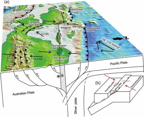
Present-day western New Guinea is part of the Australian Plate and lies adjacent to three large plates (Pacific-Caroline, Philippine Sea, and Eurasian plates) in addition to the smaller Banda Sea Plate (; Rangin et al. Citation1999; Bird Citation2003). The Caroline Plate is presently moving with the Pacific Plate or at least is only marginally different in plate motion to the Pacific Plate (Kreemer et al. Citation2000), and therefore these plates are considered jointly and referred to as the Pacific-Caroline Plate. The rate and direction of the Pacific-Caroline Plate motion is towards the west-southwest at ~110 mm per annum relative to a fixed Australian Plate (DeMets et al. Citation1994; Stevens et al. Citation2002). New Guinea including the Bird’s Head Peninsula is nominally part of the Australian Plate. However, GPS measurements indicate that the Bird’s Head Peninsula is generally moving in the direction of the Pacific-Caroline Plate with a speed of around 80 mm per annum compared with Australia and the remainder of New Guinea (Puntodewo et al. Citation1994; Stevens et al. Citation2002; Bock et al. Citation2003). Thus, it has been considered a distinct Bird’s Head Plate by Bird (Citation2003) and as the Bird’s Head Microplate by Benz et al. (Citation2011) but we prefer to consider it a deforming part of the Australian Plate. The difference in the west-southwest plate motions of the Pacific-Caroline Plate and the Bird’s Head Peninsula means some oblique convergence is occurring between them.
Figure 1. Major structural elements of western New Guinea and distribution of shallow earthquakes (<30 km depth). Tectonic features are shown (after Atmawinata et al. Citation1989; Hartono et al. Citation1989; Ratman et al. Citation1989; Pieters et al. Citation1989; Tobing et al. Citation1990; Baldwin et al. Citation2012; Hall Citation2012; Webb et al. Citation2019, Citation2020a, Citation2020b). Earthquake catalogue from GCMT (www.globalcmt.org) from 25 June 1976 to 1 July 2019. Figure base from the Digital Elevation Model (http://tides.big.go.id/DEMNAS/) and bathymetry from GEBCO (www.gebco.net). Pacific-Australian plate motion vector from DeMets et al. (Citation1994) and Stevens et al. (Citation2002). Dotted line (R.F.W.O.C.F. = Ransiki Fault-Weyland Overthrust connecting fault) is an inferred fault in western Cendrawasih Bay similar to the former suture shown by Dow and Sukamto (Citation1984) and Gold et al. (Citation2017b, figure 1). Inset shows the main plates in the New Guinea eastern Indonesia region.
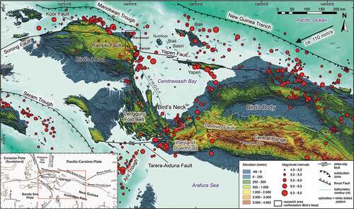
The present-day plate boundary between the Australian Plate and the Pacific-Caroline Plate in northwestern New Guinea has been shown to be along the New Guinea Trench and Manokwari Trough but deformation is dispersed across the Bird’s Head Peninsula (Decker et al. Citation2009; Baldwin et al. Citation2012). A sinistral transform boundary has been shown along the east-west trending Sorong-Yapen faults (Hall Citation2002, Citation2012; Zahirovic et al. Citation2016). However, oblique convergence is occurring across the plate boundary and is still active north of the Bird’s Head Peninsula (Puntodewo et al. Citation1994; Stevens et al. Citation2002; Bock et al. Citation2003) and can be accommodated by oblique subduction along the New Guinea Trench and the Manokwari Trough (; Milsom et al. Citation1992; Tregoning and Gorbatov Citation2004). However, whether subduction of the Pacific-Caroline Plate southwards along the New Guinea Trench is active is disputed. Arguments for subduction of a 650 km subducting slab over the past ~ 9 Ma are based on seismic tomography (Tregoning and Gorbatov Citation2004) but not recognized in an earlier seismic tomography study (Hall and Spakman Citation2003). Manokwari Trough subduction, if active, can only have been initiated in the past 2–1 Ma (e.g. Saputra Citation2021; Saputra et al. Citation2022) but the inferred subducting slab has not proceeded to a depth beyond >30 km and therefore is unable to produce melting in the underlying mantle with formation of a magmatic arc (Hamilton Citation1994). Convergence is implied along the Manokwari Trough as shown by abundant thrust-motion earthquakes along the northern coastline of the Bird’s Head Peninsula (Saputra et al. Citation2022).
Oblique convergence at the plate boundary in western New Guinea has probably operated over the past 25 Ma despite numerous small-scale changes in plate motions (Charlton Citation2000; Hall Citation2002, Citation2012). For much of this period, the plate boundary between the Australian Plate (including the Bird’s Head Peninsula) and the oceanic plates to the north (Philippine Sea and Pacific-Caroline plates) has been shown as mainly a transform fault in the plate tectonic reconstructions of Hall (Citation2002, Citation2012) and also for the past 12 Ma by Zahirovic et al. (Citation2016). These reconstructions also show the accretion of several island arcs over this interval, permitting some active convergence so that it was not always purely a strike-slip margin. An island arc was accreted to form the Central Ranges in western New Guinea () in either the Late Cretaceous or Eocene (Davies Citation2012) with emergent uplift at ~12 Ma following collision (Cloos et al. Citation2005), whereas in the northeastern Bird’s Head Peninsula () an island arc fragment was docked in the Oligocene (the Arfak Block), and accretion of the Tosem Block (Eocene-Oligocene island arc) occurred in the late Miocene to Pliocene (Pieters et al. Citation1989; Webb et al. Citation2020a, Citation2020b). Additionally, the Maramuni magmatism in the Miocene (20–10 Ma), which is well developed in Papua New Guinea (Baldwin et al. Citation2012; Holm et al. Citation2015), is also found in the Tamrau Block in the northern Bird’s Head Peninsula (Pieters et al. Citation1989; Webb et al. Citation2020a). Maramuni magmatism has been related to south-dipping subduction along the northern New Guinea margin post-dating the Eocene island arc collision (Baldwin et al. Citation2012; Davies Citation2012) but before the late Miocene collision of the Melanesian Arc (e.g. Hill and Hall Citation2003). It was suggested that subsequently the Tamrau Block may have been displaced 300 km westwards by sinistral strike-slip movements along the Sorong Fault from a location further east nearer the Bird’s Neck (Webb et al. Citation2019).
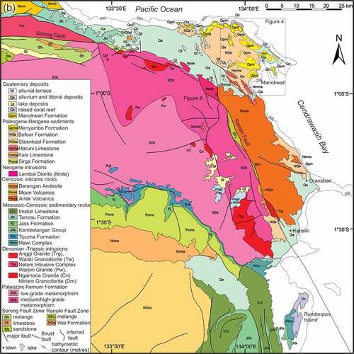
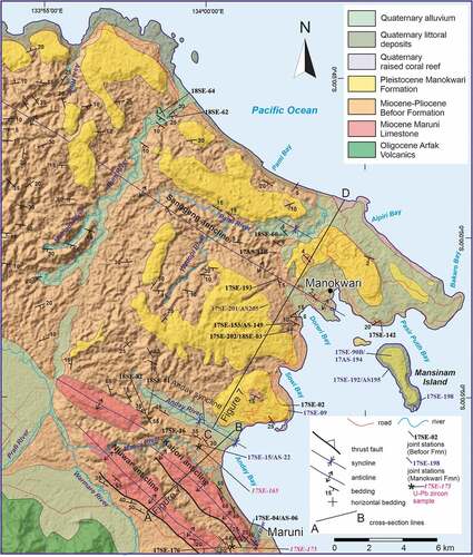
Figure 2. (a) Regional geological map of the Bird’s Head Peninsula simplified from Dow et al. (Citation1986), Watkinson and Hall (Citation2017), and Webb et al. (Citation2019). Bathymetry from GEBCO (www.gebco.net). Onland background of hillshade derived from the Digital Elevation Model (http://tides.big.go.id/DEMNAS/). (b) Simplified geological map of northeastern Bird’s Head Peninsula, Western New Guinea. Reinterpreted and updated from the 1:250 000 scale geological maps of Atmawinata et al. (Citation1989) and Ratman et al. (Citation1989). Triassic ages of intrusions from Webb et al. (Citation2019, Citation2020a, Citationb). Location shown on (a).
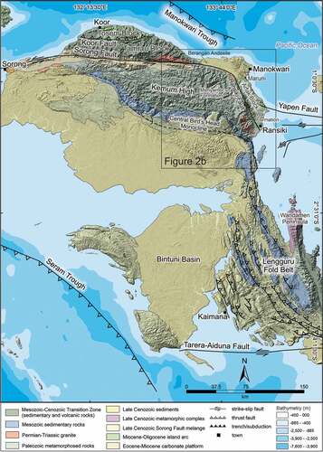
Figure 2. (Continued)
Insight into the plate boundary in northwestern New Guinea is provided by the Sumatran active margin where oblique convergence has resulted in deformation partitioned into normal subduction along the Sumatran Trench and dextral strike-slip motion along the Sumatran Fault System (Fitch Citation1972; Bock et al. Citation2003; McCaffrey Citation2009). Oblique convergence in western New Guinea has been resolved into several major sinistral strike-slip faults including the Sorong and Yapen faults (; Dow and Sukamto Citation1984; Pubellier and Ego Citation2002; Decker et al. Citation2009). Convergence along the plate boundary is potentially absorbed by subduction along the New Guinea Trench and the Manokwari Trough (Milsom et al. Citation1992; Tregoning and Gorbatov Citation2004; Saputra et al. Citation2022) in addition to shortening within the northern Bird’s Head Peninsula.
2.2. Topographic setting, blocks, and structures of the northern Bird’s Head Peninsula
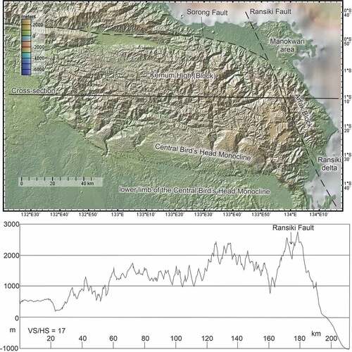
As in the Sumatran margin, deformation is more widespread in northwestern New Guinea than just that accommodated along specific structures including the Manokwari Trough, New Guinea Trench and Sorong-Yapen faults. Topography is a useful indicator of crustal strain with uplift potentially reflecting crustal shortening indicating the contractional component of oblique plate convergence (e.g. Clark et al. Citation2005). The northern part of the Bird’s Head Peninsula is a rugged mountain massif (; the Kemum High of Decker et al. Citation2009, also referred to herein as the Kemum Block) with local elevations over 2500 m above sea level and was uplifted in the Neogene and Quaternary (Robinson and Ratman Citation1977; Pieters et al. Citation1985; Decker et al. Citation2009). The Kemum High (Block) has a distinct rhombic outline 150 km east-west and 60 km north-south (). The eastern boundary of the rhombus is formed by a deep valley along the Ransiki Fault whereas the northern boundary is formed by a deep valley containing the Sorong Fault in the west and a steep north-facing escarpment in the east (Robinson and Ratman Citation1977; Dow and Sukamto Citation1984). The southern and southwestern boundaries are formed by the Central Bird’s Head Monocline (; Pieters et al. Citation1985; Atmawinata et al. Citation1989; Decker et al. Citation2009). Topographically the Kemum High slopes ca. 0.6° from east to west and is potentially expanding and uplifting towards the west.
Figure 3. Topography of the Kemum High, Digital Elevation Model and topographic cross-section. Figure base made with GeoMapApp (www.geomapapp.org), CC by (Ryan et al. Citation2009).
The Arfak Block is a steep, narrow mountainous area ca. 40 km long in a N155°E direction that forms the northeastern part of the Bird’s Head Peninsula (). The highest peaks are over 2700 m above sea level and it forms a highly dissected plateau that drops steeply to the south, east and north to the Ransiki area, the coastline and the Manokwari area, respectively (). North of Oransbari, the Arfak Block contains two east-southeast trending faults () that are probably related to the Yapen Fault. The western boundary of the Arfak Block is the Ransiki Fault, which is obscured at its northern end by the alluvial plain southwest of Manokwari and at its southern end extends into Cendrawasih Bay ().
The Manokwari area () occupies the extreme northeastern part of the Bird’s Head Peninsula (Gold et al. Citation2014, Citation2017a, Citation2017b). Topographically, the Manokwari area is characterized by a northwest-southeast trending hilly terrain with relief up to 350 m above present sea level and up to 20 km across. To the west it dies out into a coastal plain dominated by Quaternary sediments north of the escarpment formed along the Sorong Fault ().
Farther west in the northern Bird’s Head Peninsula, the Koor Fault separates the Tamrau Block to the south from the Tosem Block to the north; both blocks are mountainous () with elevations locally over 2000 m (Pieters et al. Citation1989). The Tamrau Block lies north of the Sorong Fault and continues eastwards at least as far as the Berangan Andesite, located 55 km west of Manokwari in the alluvial plain north of the Sorong Fault where no basement rocks are exposed (). The Berangan Andesite is considered Plio-Pleistocene and is the only known igneous activity of this age in the Bird’s Head Peninsula (Webb et al. Citation2020a).
The Sorong Fault is the most significant fault in the Bird’s Head Peninsula and has been considered to have played a major role in the Neogene tectonics of the eastern Indonesian region (Charlton Citation2000), although major westward transport is no longer recognized (Hall Citation2012). Based on the inferred offset of the Miocene-Quaternary basins west of New Guinea ~ 900 km sinistral strike-slip displacement was proposed by Charlton (Citation1996) but only 90–150 km offset based on the same faulted sedimentary basin was suggested by Saputra et al. (Citation2014) for the fault north of Misool. In the northern Bird’s Head Peninsula, the Sorong Fault consists of a polymict mélange with blocks of pre-Pliocene age (Hartono et al. Citation1989) and is marked by an up to 15-km-wide zone of prominent linear ridges and valleys. The Sorong Fault has Quaternary sinistral offsets of streams (Dow and Sukamto Citation1984; Watkinson and Hall Citation2017). The fault is mostly aseismic (see Saputra et al. Citation2022) apart from the 27 April 1944 earthquake relocated by Okal (Citation1999).
2.3. Overview of the basement geology of the northeastern Bird’s Head Peninsula
Despite the mountainous, jungle-clad terrain, remoteness, and general lack of access, a reasonable geological database exists because of a well-resourced joint 1:250,000 geological mapping programme that was conducted by the Geological Survey of Indonesia and Australia’s Bureau of Mineral Resources (now Geoscience Australia) mainly in the 1970s and into the 1980s (; Robinson and Ratman Citation1977, Citation1978; Pieters et al. Citation1985, Pieters et al. Citation1989). More recently geochronology, including many new U–Pb zircon ages, and updated tectonic interpretations have been given by Webb and White (Citation2016), Decker et al. (Citation2017, Citation2018), and Webb et al. (Citation2019, Citation2020a).
The Kemum High (Block) in the northern Bird’s Head Peninsula consists dominantly of low metamorphic grade (lower greenschist facies), mid Palaeozoic turbidites (Kemum Formation), with higher metamorphic-grade rocks (amphibolite facies) in the east adjacent to the Ransiki Fault (Pieters et al. Citation1985; Atmawinata et al. Citation1989; Jost et al. Citation2018, Citation2021). These rocks are moderately to steeply dipping and deformed into isoclinal folds with axial planar cleavage/foliation development (Robinson and Ratman Citation1977; Pieters et al. Citation1985). Intrusive rocks are mainly granitic and Devonian to Triassic (Jost et al. Citation2018) with less abundant middle Miocene diorite in the northeast (Lembai Diorite, Robinson and Ratman Citation1977; Pieters et al. Citation1985). The abundance of Palaeozoic orogenic rocks suggests a potential connection with the Tasman Orogenic Belt of eastern Australia, which is recognized to the east in Papua New Guinea (Hill and Hall Citation2003). Minor occurrences of reported Pleistocene shallow marine sediment (Menyambo Formation), containing foraminifera, unconformably overlie the Kemum Formation at an elevation over 1500 m (; Pieters et al. Citation1985, p. 239; Atmawinata et al. Citation1989). Unfortunately, the faunal list used to determine a Pleistocene age for this unit is missing and its age cannot be reassessed. Other reported Pleistocene shallow marine limestones have been mapped along the Ransiki Fault (upper Miocene to Pleistocene Wai beds, Pieters et al. Citation1985; Atmawinata et al. Citation1989). These occurrences are consistent with late Cenozoic uplift for at least part of the Kemum High; however, their age determinations need to be re-examined. For example, the age of the Opmorai Formation in the Tamrau Block north of the Koor Fault in the northern Bird’s Head Peninsula has been reassigned as Pliocene to Pleistocene by Webb et al. (Citation2019) from an earlier Pleistocene age given by Pieters et al. (Citation1989).
On the southern flank of the Kemum High, the Kemum Formation is unconformably overlain by the clastic Upper Triassic – Lower Jurassic Tipuma Formation that was deposited in a retroarc foreland basin related to a south-dipping subduction zone to the north of New Guinea (Gunawan et al. Citation2012). This was followed by a succession of Jurassic to Cretaceous siliciclastic sedimentary rocks that accumulated in syn-rift and post-rift settings (Decker et al. Citation2009). The succession continues with Cenozoic carbonate-siliciclastic units including the thick Eocene-Miocene New Guinea Limestone Group (Pieters et al. Citation1985). North of the Koor Fault (Tosem Block) are the late Eocene Mandi Volcanics and east of the Ransiki Fault in the Arfak Block are the Oligocene Arfak Volcanics, both island arc successions derived from the Philippine Sea Plate (Pieters et al. Citation1985, Citation1989; Webb et al. Citation2019, Citation2020a). Northeast of the eastern end of the Sorong Fault in the Manokwari region are shallow marine Miocene to Pleistocene sediments that are affected by folding and brittle deformation (Robinson and Ratman Citation1977; Robinson and Ratman, Citation1978; Gold et al. Citation2014, Citation2017a, Citation2017b), which are outlined in more detail below.
2.4. Cendrawasih Bay
East of the Bird’s Head Peninsula lies the triangular embayment formed by Cendrawasih Bay which is 250 km wide (east-west) in the north and 190 km long (north-south, ). The embayment is underlain by a sedimentary succession that thickens to the southeast to over 12 km thick as established from seismic reflection profiles (Decker et al. Citation2009; Sapiie et al. Citation2010; Babault et al. Citation2018). Basement to the embayment is not established but is thought to be oceanic and/or island arc crust (Babault et al. Citation2018). The seismic lines are unconstrained by deep wells, so the age of the succession is not directly established but is thought to have a lower part deposited in the mid Miocene to late Pliocene and a younger thicker succession formed after 3 Ma (Babault et al. Citation2018). These inferences rule out formation of Cendrawasih Bay as a triangular pull-apart formed by anticlockwise rotation of the Bird’s Head Peninsula since 5 Ma (Charlton Citation2010) but are more consistent with southwest drift of island arc volcanics and oceanic crust at 8–6 Ma into Cendrawasih Bay (Francois et al. Citation2016; Babault et al. Citation2018). This timing for emplacement of Cendrawasih Bay crust is consistent with the 5–3 Ma deformation of the Lengguru Fold Belt to the southwest (White et al. Citation2019). A northeast-verging fold-thrust belt is well imaged in the seismic profiles along the southeastern side of the embayment and is considered related to gravitational spreading in the past 0.5 Ma (Babault et al. Citation2018).
3. Methods
3.1. Field studies and remote sensing data analysis
Field studies were initially guided by the 1:250,000 scale geological maps of the Manokwari and Ransiki quadrangles (Atmawinata et al. Citation1989; Ratman et al. Citation1989). Field work has concentrated on more detailed mapping and structural appraisal of lithostratigraphic units and spatial analysis of mesoscopic structures (bedding, faults, joints, veins). Units studied in the field include the Lembai Diorite in road cuttings, the Arfak Volcanics, Maruni Limestone, Befoor Formation and Manokwari Formation in the accessible areas near Manokwari and along the coast south of Ransiki (). Field-based geological data were combined with remote sensing (Landsat images, Google Earth, the digital elevation model [DEM] from the shuttle radar topography mission [Farr et al. Citation2007], and the interferometric synthetic aperture radar surface model, Agustin, personal communication 2017).
3.2. Provenance analysis (U–Pb detrital zircon ages)
Ages of detrital zircons were determined for two samples of sandstone (one near Anday village, 17SE–165, and one near Hingk, 17SE–175, ) from the Befoor Formation (Supplementary Table 1). Standard heavy liquid and magnetic separation techniques were used to produce zircon concentrates at the mineral separation laboratory of the Research School of Earth Sciences, the Australian National University (ANU). Zircon concentrates were handpicked under a binocular microscope, and the selected grains were cast into a 1” epoxy resin disc together with the zircon Temora 2 reference material (Black et al. Citation2003). The disc was ground to reveal mid-sections through the grains and then polished with 1 µm diamond paste. The ~ 20 µm diameter sites for analysis were selected based on cathodoluminescence (CL) imagery. The zircons were analysed on the SHRIMP II instrument at the Research School of Earth Sciences at the ANU. Analytical protocols followed Williams (Citation1998), and reduction of the raw data used the ANU software ‘POXI-SC’.
Figure 4. Geological map of the Manokwari area showing northwest-southeast trending folds, with a substantial homoclinal dip to the southwest, and prominent anticlines cored by the Maruni Limestone in the southwest. Background of hillshade derived from the Digital Elevation Model (http://tides.big.go.id/DEMNAS/). Location shown on Reinterpreted and updated from the map of Ratman et al. (Citation1989) based on new mapping reported herein. Orientation data from the jungle-clad area west of the Nuni River (northwestern part of the area) is from Ratman et al. (Citation1989).
Given that very young grains were expected in the unknowns, they were analysed without auto-peak-centring on 206Pb+. Instead, locating the 206Pb+ peak relied on centring on 90Zr216O+ and using the instrument’s field calibration to determine the magnetic field necessary to measure 206Pb+. The reason for doing this is because in very young zircons, a complex molecular peak dominated by 178Hf28Si+ and 174Hf16O2+ is much larger than the almost isobaric 206Pb+ peak (as reviewed by Stern Citation1998) and can be ‘locked onto’ by auto-peak-centring, instead of measuring the adjacent 206Pb+ peak. Reinstating 206Pb+ peak centring on the interspersed Temora 2 analyses indicated a lack of magnetic drift and therefore, this was a safe procedure to measure very small 206Pb+ peaks. 206Pb/238U of the sandstone unknowns were calibrated using measurements of the Temora 2 reference material (U–Pb ages concordant at 417 Ma; Black et al. Citation2003) and the related calibration error was added in quadrature to the measurement error on the unknowns. Following normal analytical protocols (e.g. Williams Citation1998) the 206Pb/238U isotopic ratios were calibrated in 206Pb/238U versus 16O238U/238U space against Temora analyses with an age of 417 Ma.
The zircon U–Th–Pb data are presented in supplemental material. For grains >1 Ga, ages are based on estimates from the 207Pb/206Pb ratio after correction for common Pb based on measured 204Pb and a model common Pb composition (Cumming and Richards Citation1975) and for grains <1 Ga, the ages are from the 238U/206Pb ratio after correction for common Pb using the 207-method of Compston et al. (Citation1984). Reduced and calibrated data were assessed and plotted using the ISOPLOT programme (Ludwig Citation2003).
4. Data and results
4.1. Stratigraphy
Stratigraphic units in the Manokwari area are given in Supplementary Table 2. The main unit underlying the north-northwest-trending Arfak Mountains is the Arfak Volcanics (), the basement to which is not exposed. Along the northern flank of the Arfak Mountains, the Arfak Volcanics are conformably overlain by the lower to middle Miocene Maruni Limestone. The Maruni Limestone is exposed in the cores of two subparallel northwest trending anticlines that form prominent ridges 15 km south-southwest of Manokwari ( and 4) and is overlain unconformably by the upper Miocene to lower Pliocene Befoor Formation (Gold et al. Citation2017b). In coastal areas north of Oransbari and west of Ransiki the Arfak Volcanics are directly unconformably overlain by the upper Miocene to lower Pliocene Befoor Formation (; Robinson and Ratman Citation1977; Pieters et al. Citation1985; Gold et al. Citation2014).
The Lembai Diorite is located 25 km to the southwest of Manokwari and is part of a fault-bounded block in the northern part of the Ransiki Fault (). It has been related to the Moon Volcanics in the Tamrau Block 100 km west-northwest of Manokwari, because it has a close affinity in composition and age (Hartono et al. Citation1989; Webb et al. Citation2020a).
The Befoor Formation is exposed in the most northeastern part of the Bird’s Head Peninsula in the Manokwari area, in the coastal area south of Maruni towards Oransbari and inland west of Ransiki (; Robinson and Ratman Citation1977; Atmawinata et al. Citation1989; Ratman et al. Citation1989). It underlies much of the hilly country surrounding Manokwari. Sandstones in the Befoor Formation are poorly sorted, with quartz grains, volcanic rock fragments and calcareous grains. Conglomerates are widely developed, and clast types include granitoids, diorite, mafic to intermediate volcanic clasts, siliciclastic metamorphic rock fragments, vein quartz and limestone (). In the Manokwari area, conglomerates form thicker units and are coarser grained (boulders) in the southwest, closer to their highland source.
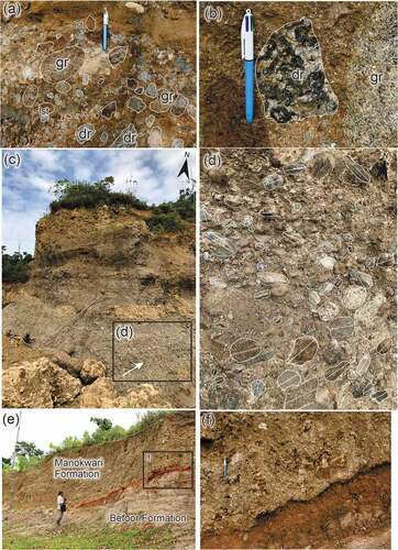
Figure 5. (a)-(d) Excavation in a quarry, Anday area, locality 17SE–165 (0°56’28.73“S, 133°59’51.00“E). Polymictic conglomerate in the Befoor Formation with clasts of granite (gr), diorite (dr), and limestone (lst). Hardened clay clasts are also present. The grain size is dominantly very coarse to fine grain/pebble, but some of the clasts have a granule size. (e) An excavation showing the contact between the Befoor Formation and the overlying Manokwari Formation, locality 17SE–39 (0°54’59.90“S, 134°1’31.70“E). Photograph shows contact (red dashed line) of reef limestone (Manokwari Formation) unconformably overlying grey mudstone (Befoor Formation). Close-up photograph given in (f).
The Manokwari Formation is the stratigraphic name given to upraised coral reefs and coralline deposits in the Manokwari area locally near, but more commonly away from the coastline (Robinson and Ratman Citation1977) and is also applied to uplifted coralline deposits in coastal areas to the southeast towards Oransbari (). In addition to the Manokwari Formation, there are many raised Pleistocene to Holocene fringing coral reefs developed around the coastline in the Manokwari area (Saputra et al. Citation2022). Alluvial and littoral deposits and landslide debris are also widely developed in the region (Robinson and Ratman Citation1977).
4.2. Structure
4.2.1. Folding in Manokwari and Maruni areas
In the Manokwari area, the Befoor Formation and underlying Maruni Limestone are folded along northwest to west-northwest trending axes (). Based on their structural characteristics there are two domains: (1) the less deformed Befoor Formation that underlies much of the Manokwari area north of the axial trace of the Anday syncline, and (2) comprising the two anticlines cored by the Maruni Formation with an intervening syncline in the Maruni area (). Domain 1 displays west-northwest trending gentle folds with steeply inclined to vertical axial planes, interlimb angles as high as 160° and zero plunge (). One main anticline and syncline pair is developed at Manokwari, whereas most of the domain consists of a south-southwest dipping succession between 5 and 40° that forms the northern limb of the Anday syncline and has a width of 10 to 11 km (Ratman et al. Citation1989), and hence contains the thickest section of Befoor Formation in the northeast Bird’s Head Peninsula. Mansinam Island is developed offshore from the anticline at Manokwari but has a north-northwest trend. The Manokwari Formation dominating the central core of this island (), the topographic elevation of up 65 m above present sea level and the raised fringing reefs are all consistent with recent uplift, possibly marking a newly forming, north-northwest-trending, gentle anticline (using the interlimb fold classification of Van der Pluijm and Marshak Citation2004).
Figure 6. Lower hemisphere equal area stereonets for poles to bedding in the Befoor Formation and Maruni Limestone for the Manokwari area. (a) Domain 1 (north of the Anday syncline, cross-section CD). Fold axis (β) = 1°/120°. (b) Hingk area (southern part of the Kabori anticline) along road into limestone quarry. Fold axis (β) = 9°/326°. (c) All bedding in Domain 2 (Maruni area, cross-section AB). Fold axis (β) = 3°/317°. (d) Contoured plot of (c).
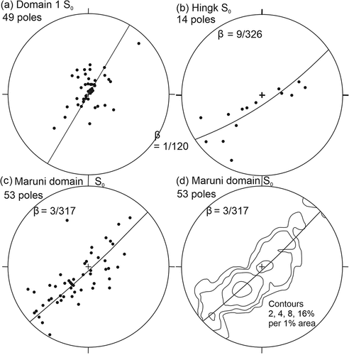
Figure 7. Cross-sections CD (a) and AB (b) of the Manokwari area. See Figure 4 for locations.

The folds around Maruni in Domain 2 consist of two northwest-trending anticlines that are upright and open; their interlimb angles are much lower than those of the folds in Domain 1 (). The Kabori anticline plunges gently to the north-northwest () and the southern termination of the anticline must therefore be faulted, although the fault is not exposed and probably overlain by river gravels. The southwestern limb of the Kabori anticline is also faulted with locally overturned Maruni Limestone thrust over Befoor Formation to the southwest (). The locally steepened limb and shape of the Kabori anticline suggest that it is a fault propagation fold related to a thrust fault dipping 40°NE parallel to the northeastern limb (). The Njuwar anticline is also interpreted as a hanging wall anticline (fault-propagation fold; ). Farther to the northwest the Kabori anticline curves in trend to the west-northwest (). In contrast to Domain 1, no flat-lying Manokwari Formation unconformably overlies these structures and given the lower thickness of the Befoor Formation in the Maruni area compared with farther north, it is also conceivable that folding and uplift began earlier than in Domain 1.
4.3. Brittle structures
4.3.1. Joints and veins
Joints and veins are widely developed in nearly all units and are regarded as mode 1 (extension) fractures and can be used to indicate the σ3 principal stress orientation and the plane containing σ1 and σ2 principal stresses at their time of formation (Hancock Citation1994). Many joints are filled with a mineral, principally calcite, and indicate extensional opening and potentially deformation under excess fluid pressures (Van der Pluijm and Marshak Citation2004; Fossen Citation2016). Some veins show development of slickenlines indicating formation as shear fractures (mode 2) and/or reactivation of extensional joints as faults (see below).
The Lembai Diorite has been examined in road cuttings in the northern part of the Arfak Block (). Many calcite-filled veins and joints are developed in it, in addition to at least one shear zone and seven veins reactivated as faults (). Several sets are present but age relationships between them could not be established. Most veins/joints are steeply dipping with a strike of northwest-southeast, but another set is steeply dipping and east-west trending in addition to another north-striking set of steeply dipping veins (). The dominant vein set implies a minimum principal stress direction (σ3) of 054–234° and given its~12° anticlockwise angle from the N156°S trend of the Ransiki Fault implies either sinistral movement along the Ransiki Fault or dextral movement along the Sorong Fault at the time of the formation of the dominant vein set. Neither of these alternatives are considered likely and it is therefore possible that block rotation has affected the fault-bound Lembai Diorite.
Figure 8. Road cutting in the Lembai Diorite; photographs taken looking to the west. (a) Shear zone (85°/065°) with left side (southwest) dropped relative to the northeastern side of the fault indicated by foliation curving into the fault plane, locality 18SE–167 (0°59’24.10“S, 133°53’4.80“E). (b) Calcite veins (dotted lines) in and adjacent to the shear zone. (c) Fault 75°/155° (in white square, see (d) for close-up photograph). (d) Slickenlines (fibrous calcite) in the fault in (c) with a pitch of 75° to the east. (e)-(f) Lower hemisphere equal-area stereonets of orientation data of structures measured in road cuttings in the Lembai Diorite (from north [0°59’19.6“S, 133°53’8.3“E] to south [0°59’39.6“S, 133°53’9.2“E]). (e) Poles to veins (126) contoured at 1, 2, 4, and 8% per 1% area. Average 79°/234°. (f) Faults and shear zones (9) plotted as great circles with slickenlines (7, black dots).
![Figure 8. Road cutting in the Lembai Diorite; photographs taken looking to the west. (a) Shear zone (85°/065°) with left side (southwest) dropped relative to the northeastern side of the fault indicated by foliation curving into the fault plane, locality 18SE–167 (0°59’24.10“S, 133°53’4.80“E). (b) Calcite veins (dotted lines) in and adjacent to the shear zone. (c) Fault 75°/155° (in white square, see (d) for close-up photograph). (d) Slickenlines (fibrous calcite) in the fault in (c) with a pitch of 75° to the east. (e)-(f) Lower hemisphere equal-area stereonets of orientation data of structures measured in road cuttings in the Lembai Diorite (from north [0°59’19.6“S, 133°53’8.3“E] to south [0°59’39.6“S, 133°53’9.2“E]). (e) Poles to veins (126) contoured at 1, 2, 4, and 8% per 1% area. Average 79°/234°. (f) Faults and shear zones (9) plotted as great circles with slickenlines (7, black dots).](/cms/asset/72b49c62-4099-4a7b-998f-19569d8fb174/tigr_a_2188404_f0008_c.jpg)
Joints and calcite-filled veins have been measured at 14 localities in the Befoor Formation in the Manokwari and Maruni areas (Supplementary Table S3; ). Although this unit is only partially lithified it was coherent enough to undergo brittle fracture. Joints are thought to be extensional, because no offsets of markers were found, and also some of the joint sets are filled with calcite, consistent with an origin by mode I fracture. This is also shown by plumose structure found along a joint (). It is clear from the stereographic plot of all joints/veins from all localities that orientations vary greatly in strike, but most fractures have dips >45° (). From examination of the fracture orientations at these different localities (Supplementary Table S3; ) a number of joint sets are evident.
Figure 9. Plumose structure showing hackle fringe and propagation direction along a northeast-trending vertical joint in the Befoor Formation near Manokwari, locality 17SE–01 (0°52’30.08“S, 134° 2’49.16“E).
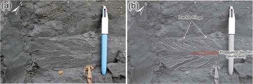
Figure 10. Lower hemisphere equal-area stereonets (number of poles to planes given at lower right for each stereonet) and photographs of joints in the Befoor Formation. (a) All joints/veins in the Manokwari area. (b) Contoured plot of (a) at 1, 2, 4 and 8% per 1% area. (c) Poles to joints (S0 25°/160°) at locality 18SE–60 with dominant east-southeast set of joints (0°46’4.21‘S, 133°58’37.50“E). Average orientation of the east-southeast joint set is 90°/206°. (d) Outcrop in the Pami River, same location as (c). (e) Outcrop in the Nuni River (locality 18SE–62, 0°46’12.8”S, 133°58’56.5’E). Average 76°/290°. (f) Road cutting in Befoor Formation showing 2 sets of joints/veins at locality 18SE–82 (0°55’36.968“S, 133°57’16.75“E). (g) Lower hemisphere equal-area stereonets of poles to veins from locality 18SE–82 (S0 not determined) with 2 average orientations (53°/301°, 61°/135°). (h) Locality 17SE–153/AS-149 (0°52’39.175“S, 134°2’45.688“E, S0 10°/220°) with several orientations of joints. (i) Poles to two joint sets at locality 17SE–202 (0°52’52.006“S, 134°2’41.992“E, S0 flat-lying), left average 77°/136°, right average 55°/226°.
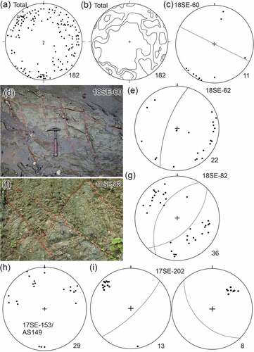
An east-southeast striking, steeply-dipping joint set is found at three localities around Manokwari (18SE-60, 17SE-193, 17SE-202, ) including one site close to the crest of the Sanggeng anticline (17SE-193, ) and are oriented subparallel to the main fold axial plane and therefore are considered b-c fractures (i.e. related to the folding with tension induced by stretching on the outer arcs of folds, Stearns Citation1968; Vergunst et al. Citation2019). East-southeast-trending joints are also found at the Nuni River (18SE-64, ) and are probably part of this set.
Steeply dipping joints having north to northeast trends are found at eight localities (18SE-62, 18SE-64, 18SE-60, 17SE193, 17SE153/AS-49, 17SE-202, 17SE-16, 18SE-82, ) and are developed perpendicular to or at a high-angle to the regional fold trends. Given their orientation with respect to the regional folds, these are interpreted as a-c joints having formed in the direction of maximum principal stress.
Joints at other localities are not readily interpreted in terms of regional stress directions. At localities 17SE-04/AS-06 and 17SE-176 () joints occur subparallel to bedding in conglomerates and are therefore probably developed as sheeting prior to tilting of the layers.
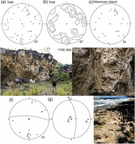
It is clear from ) that there is greater variation in the orientation of joints in the Manokwari Formation compared with the Befoor Formation and given the large variations in dip, this could reflect a number of unsystematic joint orientations and therefore are of lesser value for determining regional stress orientations. Given the late Pleistocene age for a portion of the Manokwari Formation (Saputra et al. Citation2022) it is likely that it was either at or just below the surface, and thus it is unsurprising that no consistent stress pattern is recognizable.
Figure 11. Lower hemisphere equal-area stereonets of structures in the Manokwari Formation. (a) Total poles to joints. (b) Total poles to joints contoured at 2, 4, and 6% per 1% area. (c) Poles of all joints measured at the three localities on Mansinam Island. (d) Outcrop of reef limestone of the Manokwari Formation at locality 17SE-09A (0°55’26.963“S, 134°2’39.792“E) showing joints and a fault plane. (e) Close-up photograph of the fault plane in (d) and showing down-dip slickenlines. (f) 19 poles to joints at locality 17SE-09A, with an average of 77°/005° for 12 joints. (g) Fault with slickenlines and principal stress directions. (h) Stylolitic joint on the western side of Mansinam Island (0°54’7.349“S, 134°5’44.443“E).
4.3.2. Faults
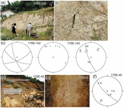
Mesoscopic faults and shear zones with limited offsets are rare but have been documented at several sites in the northeastern Bird’s Head Peninsula (). In the Lembai Diorite, a shear zone is developed with foliation in the diorite curving into the zone and indicating that the northeastern block is upthrown (). Slickenlines in this zone are almost horizontal and indicate strike-slip movement in contrast to the curving foliation consistent with dip-slip movement along the shear zone. Additionally, 8 faults (most likely reactivated from the joints) and a single shear zone were measured with a variety of 7 slickenline orientations along the faults (). They are generally steeply dipping and have mainly east-west strikes () which are suggestive of high-angle reverse movements as in the shear zone. Minor normal faults have been recognized in the Befoor and Manokwari formations as well as a sinistral strike-slip fault in the Befoor Formation ().
Figure 12. (A) Excavation in Befoor Formation that shows bedding (S0 20°/305°), small faults, and joints, locality 17SE–142 (0°52’39.751“S, 134°5’21.352“E). (b) Close-up of small fault showing gently plunging slickenlines. (c) Lower hemisphere equal-area stereonets; left, 3 great circles to faults, middle, 8 poles to joints, and right, principal stresses related to small sinistral strike-slip fault with slickenlines in (b). (d) Outcrop of fault scarp in the Befoor Formation overlain by Manokwari Formation at locality 17SE–40 (0°54’50.259“S, 134°1’30.528“E). (e) Steeply pitching slickenlines (dotted white line) along the fault surface (as shown in box in (d)). (f) Lower hemisphere equal-area stereonet showing normal fault (great circle), slickenlines (cross, sl) and principal stress orientations.
4.4. Provenance of the Befoor formation
Conglomerates in the Befoor Formation are polymictic, with rock fragments of granite, chert, hardened clay, diorite, limestone, mafic-intermediate volcanic rocks, and siliciclastic metasedimentary clasts () and have a source generally from the south and southwest. Source rocks are the metamorphic rocks of the Kemum Formation, granitic intrusions in the Kemum High, the Lembai Diorite, the Arfak Volcanics, and limestone (Atmawinata et al. Citation1989; Ratman et al. Citation1989).
Data for the zircon ages from the sandstone samples of the Befoor Formation are given in the supplemental material and . A mosaic of cathodoluminescence imagery for all mounted grains with those that were analysed indicated, is presented as Supplementary Figure S1. For sample 17SE–175 (), only three zircons were recovered, which are all of non-rounded and stubby prismatic to anhedral habit, and in CL images show broad zoning. They have 238U/206Pb ages of 30.80 ± 0.69, 29.26 ± 0.61 and 29.95 ± 0.76 Ma, (1σ; early Oligocene, Rupelian). These ages are consistent with a source from the adjacent Oligocene Arfak Volcanics of the Arfak Block (Supplementary Figure S2; Webb et al. Citation2020a).
Figure 13. Detrital zircon ages from the Befoor Formation. (a-b) 238U/206Pb–207Pb/206Pb concordia diagrams (errors given at the 2σ level). (c-d) U–Pb age histogram and cumulative frequency plots.
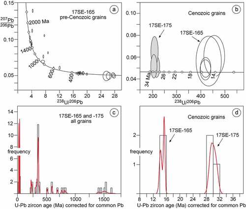
For sample 17SE–165 (), 37 zircons were extracted, and four grains have had duplicate analyses determined, giving a total of 41 ages (). However, several analyses were discarded because of high discordance of U-Pb ages in >1 Ga grains, high U + Th and high common Pb content (analyses 23.1, 23.2, 18.1 see supplemental material). The four youngest ages with duplicate analyses are from grains 6 and 33. Following recognition of grains with the youngest apparent 206Pb/238U ages, duplicate analyses were undertaken to establish whether those ages reproduced or are a function of minor loss of radiogenic Pb. The two analyses of grain 6 prismatic fragment were undertaken on the end and centre and show partly recrystallized oscillatory zoning in CL imagery. The two analyses of grain 33 were undertaken on a grain fragment which appears uniform in CL imagery. Respectively, grains 6 and 33 have ages of 15.22 ± 0.32 and 15.32 ± 0.36 Ma (95% confidence weighted mean 15.26 ± 0.47 Ma, MSWD = 0.04) and 14.73 ± 0.69 and 13.91 ± 0.52 Ma (95% confidence weighted mean 14.20 ± 0.81 Ma, MSWD = 0.90). These provide a maximum middle Miocene (Langhian) depositional age for the Befoor Formation at this locality. However, the Befoor Formation has a younger palaeontologically determined age of upper Miocene to lower Pliocene (11.6 to 3.6 Ma; Gold et al. Citation2014, Citation2017a, Citation2017b). These U-Pb zircon ages are consistent with the final middle Miocene igneous activity that affected the island arc rocks of the Arfak Volcanics and associated plutonic rocks (e.g. the Lembai Diorite; Webb et al. Citation2020a, Citation2020b). This confirms the source of intermediate-mafic volcanic and dioritic clasts in conglomerates in the Befoor Formation.
A second group of three grains (four analyses) have Triassic ages and are of variably rounded habit, with CL imagery of grain 19 showing truncation of internal oscillatory zoning at the grain boundary. The 238U/206Pb ages are 247.1 ± 4.4 Ma, 240.9 ± 3.5 Ma, and duplicate ages for grain 19 are 227.8 ± 2.7 Ma and 229.9 ± 2.7 Ma (95% confidence weighted mean 228.9 ± 3.7 Ma, MSWD = 0.30; Lower Triassic, Carnian). These ages are consistent with ages of Permian to Triassic granites in the Kemum High (Jost et al. Citation2018) and also the Netoni intrusive complex north of the Sorong Fault in the central-northern Bird’s Head Peninsula (Webb and White Citation2016). Apart from the Netoni Complex, which lies 100 km west of the sample site and unlikely to be a direct source, these granitic intrusions are of restricted exposure compared with the surrounding Kemum Formation () and are therefore unlikely to be a major source of zircons (3 grains in total). A more significant group are the 17 ages from ~ 315 Ma to 371 Ma and related to the Late Devonian to Carboniferous silicic igneous activity documented by Jost et al. (Citation2018) in the Kemum High. Units include the Miriam Granodiorite and Ngamona Granite (Jost et al. Citation2018), and may have included volcanic equivalents that have been removed by erosion.
The remaining ages are divided into two groups: (1) Neoproterozoic zircons, indicative of a Pacific-Gondwana source that is widely recognized in ancient fragments of Gondwana (Martin et al. Citation2017), and (2) >1400 Ma zircons that are most likely originally derived from the North Australian Craton (e.g. the lower Palaeoproterozoic Kimberley orogen in northern Australia, Cawood and Korsch Citation2008; Southgate et al. Citation2011). It is clear from the limited data given in Decker et al. (Citation2017) that these two groups of detrital zircons are most likely derived from the Kemum Formation and its metamorphic equivalents, which are widespread in the Kemum High. They have therefore been recycled from Australian craton Precambrian basement. However, given their age, transmitted light and CL imagery indicate that many of these grains are not significantly rounded, and therefore did not have multiple or long residence times in sedimentary transport systems.
5. Discussion
The stratigraphic succession and structures are interpreted in the context of the Miocene to Pleistocene development of the northern New Guinea margin and includes a discussion of strike-slip tectonics. Strike-slip movements have long been proposed for the Sorong Fault and considered to be of major importance in the development of eastern Indonesia (e.g. Hamilton Citation1979; Dow and Sukamto Citation1984; Charlton Citation1996, Citation2000) and have been included in recent interpretations (Webb et al. Citation2019, Citation2020a). In contrast to other examples of major strike-slip faults (e.g. the Alpine Fault of New Zealand, Norris and Cooper Citation2007), no specific offset basement geologic features have been recognized. Our work has shown that significant strike-slip tectonics must have largely predated deposition of the upper Miocene to lower Pliocene Befoor Formation (see below) although minor movements have continued up to the present (Watkinson and Hall Citation2017). Folds reflecting shortening affected the upper Miocene to lower Pliocene deposits in the Manokwari area but predate the Pleistocene Manokwari Formation and are related to compression from the north-northeast. Development of the Kemum High is related to continued deformation at a restraining bend in the Sorong-Ransiki-Yapen faults as well as shortening driven by resolved north-northeast compression from partitioned oblique convergence.
5.1. Tectonic significance of the stratigraphy, provenance, and structure of the Manokwari area
The mostly Oligocene Arfak Volcanics represent part of the island arc formed on the southern side of the Philippine Sea Plate by northward subduction of the Australian Plate (Hall Citation2002, Citation2012; Hill and Hall Citation2003; Gold et al. Citation2014; Webb et al. Citation2020a). They must have docked with the northern passive margin of New Guinea in the late Oligocene to earliest Miocene based on two constraints. Firstly, they are intruded by intermediate igneous rock in the middle Miocene as part of the Maramuni Arc magmatism that affected the northern margin of New Guinea (Baldwin et al. Citation2012; Davies Citation2012; Webb et al. Citation2019, Citation2020a). Secondly, they are overlain by the lower to middle Miocene Maruni Limestone, which is consistent with termination of island arc volcanism and therefore subduction no later than the earliest Miocene (~23 Ma). The Maruni Limestone is a biomicrite and has no clastic input (Robinson and Ratman Citation1977) indicating that docking of the unit was not accompanied by uplift and/or deformation. The Arfak Volcanics may well have been transported westwards by strike-slip faulting (e.g. Webb et al. Citation2020a) as well as being subsequently displaced southwards by offset along the Ransiki Fault (see below). In contrast to Eocene to Oligocene island arc collisions further east in New Guinea (e.g. Mahoney et al. Citation2019) an island arc collision was not recorded in northwestern New Guinea and instead is attributed to docking with cessation of north-dipping subduction beneath the Arfak Block at a strike-slip fault boundary as shown in plate tectonic reconstructions by Hall (Citation2002, Citation2012).
The Maruni Limestone was deposited as part of widespread shallow marine conditions (20–100 m water depths) throughout New Guinea in the early to middle Miocene (the New Guinea Limestone Group and equivalents, Gold et al. Citation2017a) and indicates relative stability. Intrusions of the Lembai Diorite in the middle Miocene (Pieters et al. Citation1985) and a comparable quartz diorite in the Arfak Volcanics dated at 13.6 ± 1.0 Ma (Webb et al. Citation2020a) occurred during deposition of the Maruni Limestone. These Miocene intrusions are consistent with the timing of Maramuni magmatism (20–10 Ma, Baldwin et al. Citation2012) that is also represented by the widespread Miocene Moon Volcanics in the Tamrau Block () and interpreted as related to south-dipping subduction along the New Guinea margin (Davies Citation2012; Webb et al. Citation2019, Citation2020a). Maramuni arc volcanism may have been caused by loss of the north-dipping subduction zone due to the Oligocene – earliest Miocene island arc docking event.
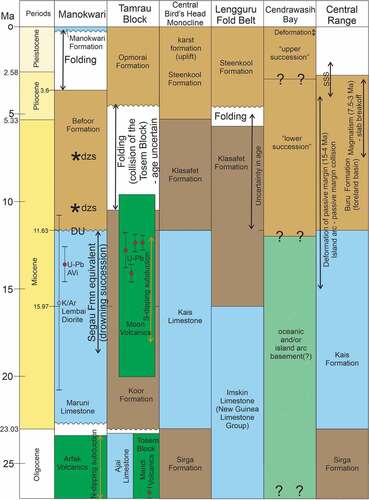
Figure 14. Time-space plot for the past 25 Ma showing comparisons of main stratigraphic units, main tectonic events and radiometric ages for the Manokwari area (Robinson and Ratman Citation1977; Gold et al. Citation2014, Citation2017a, Citation2017b; this work), the Tamrau and Tosem blocks (Pieters et al. Citation1989; Webb et al. Citation2019, Citation2020a, Citation2020b), the Central Bird’s Head Monocline (Pieters et al. Citation1985; Thery et al. Citation1999), Lengguru Fold Belt (Dow and Sukamto Citation1984; Bailly et al. Citation2009; White et al. Citation2019), Cendrawasih Bay (Babault et al. Citation2018), and the Central Ranges of western New Guinea (Cloos et al. Citation2005; Quarles van Otford and Cloos Citation2005). The 20 m thick drowning succession overlying the Maruni Limestone is described as an equivalent of the Segau Formation by Gold et al. (Citation2017b) from a locality 18 km south-southwest of Manokwari (see text). Radiometric ages for the Manokwari area from Pieters et al. (Citation1985, K-Ar age from the Lembai Diorite) and Webb et al. (Citation2020a, U-Pb zircon age from a diorite intrusion into the Arfak Volcanics, AVI). Radiometric ages for Tamrau Block from Webb et al. (Citation2020a, U-Pb zircon ages, Moon Volcanics). The Cendrawasih Bay column is based on seismic data and modelling after Babault et al. (Citation2018). Abbreviations: dzs, detrital zircon samples at approximate stratigraphic level in the Befoor Formation (this work, see text); SSS, sinistral strike-slip faulting in the Central Range.
The unconformity documented by Gold et al. (Citation2017b) at the base of the Befoor Formation is of regional extent and post-dates a drowning succession above the Maruni Limestone in the greater Bird’s Head Peninsula region formed from 18 to 11.6 Ma. The drowning succession is diachronous and youngs westward as determined from petroleum wells in the western and southern parts of the Bird’s Head Peninsula region (Gold et al. Citation2017b). It is related to the general increase in sea levels in the Miocene and also reflects regional extension (Gold et al. Citation2017b). In the northeastern Bird’s Head Peninsula the unconformity is associated with uplift of part of the Kemum and Arfak blocks. This is shown by conglomerates that are prominent in the southwestern part of the overlying upper Miocene to lower Pliocene Befoor Formation () and decrease northwards as well as becoming finer grained to the northeast around Manokwari indicating a source to the southwest. Clast compositions indicate derivation from sources in both the Kemum and Arfak blocks. Given that the northern part of the Arfak Block is overlain by the drowning succession with an age of Burdigalian to latest Serravallian (18–11.63 Ma, Gold et al. Citation2017b), the age of initiation of the uplift is earliest late Miocene. This uplift is unlikely to have been widespread as shallow marine sediments were common in the late Miocene across the region (Gold et al. Citation2017a).
The detrital zircon U–Pb age data confirms the provenance of the Befoor Formation in the Kemum and Arfak blocks. Sample SE-175 recovered few zircons but all three indicate a source from the Arfak Volcanics consistent with uplift of at least part of the Arfak Block in the earliest late Miocene. For sample SE-165, the youngest cluster of zircon ages indicate a maximum depositional age no younger than mid Miocene (average of 4 ages, 14.8 ± 0.5 Ma) and older than the palaeontologically determined age of the Befoor Formation. These zircons may well have been derived from the Lembai Diorite and are consistent with the K/Ar age of 15.8 ± 5 Ma for this unit (Pieters et al. Citation1985) and potentially indicate that the diorite was exposed in the late Miocene to early Pliocene. Detrital zircon ages from this sample also show that the source included the Kemum Formation (e.g. Decker et al. Citation2017) but the prominent cluster in the range ~ 371 Ma to 315 Ma () indicates the importance of Upper Devonian to Carboniferous igneous sources in the Kemum Block (Jost et al. Citation2018.
The localized uplift of the Kemum and Arfak blocks and deposition in the adjacent Manokwari area in the late Miocene to early Pliocene is a tie point across the Sorong and Ransiki faults and shows that only minor strike-slip offset has subsequently occurred since 12 Ma. In the reconstructions given by Hall (Citation1996, Citation1997, Citation2002, Citation2012) and Charlton (Citation2000) strike-slip faulting along the northern margin of New Guinea began after 25 Ma. It is therefore proposed that the Sorong and Ransiki faults were active with significant sinistral strike-slip movement from 25 Ma and until ~12 Ma. The ~ 40 km of offset of the Sorong and Yapen faults by dextral movement along the Ransiki Fault (Puntodewo et al. Citation1994) most likely occurred just before deposition of the Befoor Formation as shown by the lack of uplift prior to development of the restraining bend along the Sorong-Yapen faults. Any significant strike-slip movement since 12 Ma presumably has occurred further north accommodated along structures including the Manokwari Trough and/or Koor Fault (see also Charlton Citation2000).
5.1.1. Papua-style oblique convergence
The Indonesian archipelago is a region influenced by the Eurasian Plate (Sundaland), the Pacific-Caroline Plate, the Philippine Sea Plate, and the Australian Plate in Southeast Asia. Beck (Citation1983) proposed the term ‘Sunda style’ for the slip partitioning and formation of the dextral Sumatra Fault developed from the oblique convergence between the Eurasian (Sundaland) and Australian plates. The Sunda style is associated with long-lived subduction and a well-developed magmatic arc (McCaffrey Citation2009; Hall Citation2012). In contrast to the Sunda style of oblique plate convergence, the ‘Papua style’ is markedly different () and lacks evidence for long-lived subduction along the Australian/Papuan margin in the Cenozoic with only indications of relatively short-lived arcs (e.g. Maramuni Arc). Impressive strike-slip faults are developed in the Papua style, but they show only evidence for intermittent displacements. In the past 25 Ma the northwestern New Guinea margin has been affected by both oblique convergence as is occurring today (Puntodewo et al. Citation1994; Stevens et al. Citation2002; Baldwin et al. Citation2012; Saputra et al. Citation2022), and strike-slip tectonics with westward displacement of plates to the north as shown in a much wider context in the plate reconstructions of Hall (Citation1996, Citation1997, Citation2002, Citation2012) and Zahirovic et al. (Citation2016). Contractional deformation and uplift is most evident for the past 4 Ma in the Bird’s Head Peninsula (see below). The Papua style is complicated by the presence of an oceanic embayment (Cendrawasih Bay, see below).
Figure 15. (a) Block diagram illustrating kinematic partitioning of oblique convergence (without scale) in northwestern New Guinea. GPS vector (black arrow) based on DeMets et al. (Citation1994), Bock et al. (Citation2003) and Puntodewo et al. (Citation1994). The diagram shows partitioning as is occurring in the last 4 Ma and also notes the timing of major shortening events in the region (Cloos et al. Citation2005; White et al. Citation2019; this paper). Note that shortening in the Lengguru Fold Belt region (including the adjacent Wandamen Peninsula) was replaced by extension post 3 Ma. (b) Block diagram showing oblique convergence (adapted from McCaffrey Citation2009).
5.1.2. Localized uplift of the Kemum and Arfak blocks associated with a double restraining bend in the Sorong-Ransiki-Yapen faults (11.6–3.6 Ma)
Uplift of the northeastern part of the Kemum Block and adjacent Arfak Block during deposition of the upper Miocene to lower Pliocene Befoor Formation was driven by shortening associated with compression across a locked double restraining bend in the linked Sorong, Ransiki and Yapen faults (). The double restraining bend formed from dextral offset of the Sorong and Yapen faults by the Ransiki Fault most likely in the late middle Miocene. Movements of blocks either side of the Sorong Fault prior to this offset during deposition of the Maruni Limestone were not associated with uplift (Gold et al. Citation2017a). The contrast in basement types between the continental basement of the Bird’s Head Peninsula and the probably partly oceanic and more rigid basement of the adjoining Cendrawasih Bay (cf. Beck et al. Citation1993) has effectively locked in the present-day orientation of the Ransiki fault. This has prevented either rotation of the restraining bend, as reported for the Akato Tagh bend along the Altyn Tagh Fault (Cowgill et al. Citation2004), or migration of the restraining bend along the Sorong Fault, as shown for bends along the San Andreas Fault (Wakabayashi Citation2007).
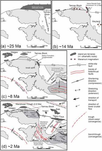
Figure 16. Tectonic evolution of the Bird’s Head Peninsula in the last 25 Ma influenced by oblique convergence of the Australian, Philippine Sea and Pacific-Caroline plates (see text). Oblique plate convergence is resolved into north-northeast shortening and sinistral east-west strike-slip faulting. (a) Docking of an island arc terrane of unknown extent at ~ 25 Ma accompanied by development of the Sorong Fault. (b) At ~ 14 Ma strike-slip movement has ceased along the Sorong Fault after offset of the Tamrau Block (Webb et al. Citation2019, Citation2020a) and followed by oblique subduction (trench not shown) to form the Maramuni igneous rocks. This preceded dextral movement along the Ransiki Fault that offset the Arfak Block (AB) southwards. Location of the Maramuni igneous rocks in the Weyland Overthrust is uncertain but must have lain north of their present location. (c) At ~ 8 Ma major orogeny was active in the Central Range (Sapiie and Cloos Citation2004; Cloos et al. Citation2005). It is uncertain when subduction was initiated along the New Guinea Trench. No major strike-slip movement occurred since 12 Ma along the Sorong Fault as shown by the tie point indicated by uplift of the northeastern Kemum Block and adjacent Arfak Block (AB) that provided a source of detritus to the Befoor Formation. Strike-slip movements may have been more substantial along faults (not shown) in the island arc terrane north of New Guinea. Basement to Cendrawasih Bay was transported from the northeast during the interval 8–6 Ma to its approximate present location (Francois et al. Citation2016; Babault et al. Citation2018). Shortening in the Central Range accompanied by southward emplacement of the Central Range ultramafic belt initiated at 12 Ma (Cloos et al. Citation2005). The Tosem Block was being emplaced southwards onto the northern part of the Bird’s Head Peninsula (Webb et al. Citation2020a). (d) At ~ 2 Ma shortening had been completed in the Lengguru Fold Belt and Wandamen Peninsula (5–3 Ma, White et al. Citation2019). North-northeast convergence is accommodated by subduction along the New Guinea Trench and the Manokwari Trough (past ~ 2–1 Ma only). Limited sinistral strike-slip faulting along the Yapen Fault and in the Central Range (at 4–2 Ma, Sapiie and Cloos Citation2004; Sapiie Citation2016). North-northeast shortening caused folding in the Manokwari area, shortening, and resulting uplift of the Kemum High (also accommodates limited strike-slip movement along the Sorong Fault). Extension occurred from <3 Ma in the Wandamen Peninsula (White et al. Citation2019).
5.1.3. Late Pliocene to Early Pleistocene compressional deformation in the Manokwari area related to partitioned north-northeast convergence and uplift of the Kemum High
Deformation in the Manokwari area is shown by the uplift and erosion of the Befoor Formation associated with formation of the unconformity underlying the Manokwari Formation () in the late Pliocene and Pleistocene. Structures that predate the unconformity are the map-scale folds that trend east-southeast to southeast (). In the southwest of the Manokwari area, the anticlines containing the Maruni Limestone are slightly convex to the northeast and mimic the northern exposed margin of the Arfak Volcanics in the Arfak Block (). It is also evident from the cross-sections () that shortening is higher adjacent to the recently uplifted northern part of the Arfak Block and decreases northwards as shown by the gentle interlimb angles of the regional folds around Manokwari. Thus, during the late Pliocene to Early Pleistocene north-northeast to northeast shortening the folding was more intense in the bedded sediments adjacent to the Arfak Block and decreased to the northeast (). A similar phenomenon, referred to as buttressing by O’dea and Lister (Citation1995), has resulted in shortening in metasedimentary units increasing towards a previously existing uplifted, competent horst block in the Proterozoic Mount Isa Inlier in northeastern Australia. Buttressing may also be responsible for the rising steps in topography evident eastwards across the Kemum High ().
In the upper Pliocene to upper Pleistocene, northwestern New Guinea was undergoing oblique convergence and has been partitioned into subduction along the New Guinea Trench, and more recently the Manokwari Trough (Milsom et al. Citation1992; Tregoning and Gorbatov Citation2004), and strike-slip faulting along the Yapen Fault and with minimal movement along the Sorong and Ransiki faults. In this arrangement, the Manokwari area is in the hanging wall of the south-dipping slab associated with the Manokwari Trough () and analogous to the forearc sliver platelet in southwestern Sumatra (McCaffrey Citation2009). Given the relatively young age and hence relative buoyancy of sea floor being subducted at the New Guinea Trench and Manokwari Trough (<40 Ma and <15 Ma, respectively, Weissel and Anderson Citation1978; Gaina and Müller Citation2007), the Manokwari area is likely to have been affected by a component of shortening as shown by the folding of the Miocene-Pliocene sedimentary succession. The orientations of the folds indicate that the maximum principal stress was oriented in a north-northeast to northeast direction consistent with the partitioned plate convergence direction. The orientation of stresses associated with the folding is also consistent with fold-related thrust faults, and associated a-c and b-c extension joints. This is similar to the northwestern part of the Bird’s Body where widespread more intense shortening has affected the late Cenozoic sedimentary succession of the Mamberamo Basin (Williams and Amiruddin Citation1984; Davies Citation2012).
The present-day Kemum High is related to development of the Central Bird’s Head Monocline that must have formed after deposition of at least the Kais Limestone, but probably also the Klasafet and Steenkool formations (see cross-sections in Atmawinata et al. Citation1989), indicating that uplift was mainly Pleistocene. Development of Pleistocene underground drainage systems in the Kais Limestone along the southern flank of the uplift are consistent with this young age of uplift (Thery et al. Citation1999). It is also supported by deposition of the probable Pleistocene Upa Conglomerate southwest of the Central Bird’s Head Monocline with its clasts indicating derivation from the Kemum High (Pigram and Sukanta Citation1982).
Development of the Kemum High is consistent with the slip partitioning of the oblique plate convergence vector with sinistral movement along the linked strike-slip faults and convergence responsible for crustal thickening and resulting uplift. The pre-existing locked double restraining bend in the linked Sorong-Ransiki-Yapen faults may have nucleated the younger uplift of the whole rhombic Kemum High (<4 Ma). This has also accommodated sinistral motion along the Yapen Fault and also allowed intermittent sinistral slip along the Sorong Fault that accounts for the geomorphic evidence for Quaternary slip along the Sorong Fault in the northern Bird’s Head Peninsula (Dow and Sukamto Citation1984; Watkinson and Hall Citation2017). Uplift of the Kemum High was only partially driven by renewed shortening across the locked Ransiki Fault segment of the Sorong-Ransiki-Yapen fault after its earlier phase in the late Miocene to early Pliocene. We consider that the uplift of the Kemum High was mostly driven by crustal shortening from north-northeast compression caused by the partitioned convergent vector from the overall oblique convergence. This oblique convergence has been active over the past 4 Ma and is consistent with the band of thrust earthquakes along the northern coastline of the Bird’s Head Peninsula as well as sinistral strike-slip first motion mechanisms along the Yapen Fault (Decker et al. Citation2009; Saputra et al. Citation2022). The Kemum and Arfak blocks are relatively rigid at least in the upper crust and one mechanism that can accommodate the overall shortening is lower crustal flow (cf. Royden et al. Citation2008) with formation of the Central Bird’s Head Monocline and gradual lateral growth westwards to form the present-day high with a declining westward slope ().
Elevations of the Manokwari Formation and upraised coral reefs fringing the coastline shows that this uplift is continuing (Saputra Citation2021; Saputra et al. Citation2022). Given the young age of the upper Pleistocene Manokwari Formation, all structures within in it are potentially neotectonic. The Manokwari Formation contains joints, many of which are unsystematic and of limited use in documenting the stress field, but at least some structures are consistent with north-northeast compression as developed in the late Pliocene to early Pleistocene.
5.1.4. Constraints from Cendrawasih Bay
The origin of Cendrawasih Bay is problematic but the available seismic lines and modelling of sedimentation by Babault et al. (Citation2018) rules out its development by anticlockwise rotation of the Bird’s Head Peninsula post 5 Ma (Charlton Citation2010). Instead, basement to Cendrawasih Bay may well have arrived at close to its present location at 8–6 Ma following ophiolite emplacements in the Weyland Overthrust and Central Ranges (Francois et al. Citation2016; Babault et al. Citation2018). In the late Pliocene to present extension is considered to have affected the Wandamen Peninsula on the western side of Cendrawasih Bay (White et al. Citation2019) and coincides with formation of a depositional wedge of sediments in southeast Cendrawasih Bay derived from the uplifted Central Ranges to the southeast and the Weyland Overthrust to the south (Babault et al. Citation2018). Extension in this region is attributed to the westward escape of the Bird’s Head Peninsula and Neck (Pubellier and Ego Citation2002) whereas compression occurs to the northwest in the northeastern Bird’s Head Peninsula closer to the Pacific-Australian plate boundary.
5.2. Regional setting and tectonic history of the Bird’s Head Peninsula in the past 25 Ma
The tectonic history of the Bird’s Head Peninsula over the past 25 Ma has been controlled by the development of the active plate boundary along the northern margin of New Guinea. For much of that interval, the plate boundary has been with the Philippine Sea Plate, which has had a well-documented clockwise rotation over the past 50 Ma (Hall et al. Citation1995; Wu et al. Citation2016). The southern part of the plate boundary along northwestern New Guinea was mainly undergoing sinistral oblique convergence (), possibly with intervals of pure strike-slip tectonics but unlikely to remain long-lived. This is consistent with the evidence for repeated island arc accretion along the New Guinea margin (Hill and Hall Citation2003; Baldwin et al. Citation2012; Davies Citation2012; Mahoney et al. Citation2019) as well as different styles of deformation along the margin, which we relate to deformation partitioning during oblique convergence. How the deformation and tectonic history has evolved over the past 25 Ma is outlined below in four time-slices ().
5.2.1. 25–20 Ma island arc docking and strike-slip faulting
The timing of collision of island arcs in western New Guinea is constrained in the Central Ranges where Cloos et al. (Citation2005) emphasized mountain building from ~ 12 Ma following collision, although did not specify the timing of the initial contact with the passive margin. Docking as old as either Late Cretaceous or Eocene based on the ages of high temperature metabasites and blueschist metamorphic rocks, respectively, has been suggested (Davies Citation2012). The docking of the island arc is more tightly constrained in the northern Bird’s Head Peninsula where the Arfak Volcanics are mainly Oligocene and intruded by diorite at 13.6 Ma (Webb et al. Citation2020a) and post-dated by the lower to middle Miocene Maruni Limestone, which we interpret as having deposited following cessation of subduction. Oblique convergence resulted in docking of the island arc without significant deformation (i.e. no mountain building) and strike-slip faulting involving the formation of the east-west trending Sorong-Yapen fault system. An unknown amount of strike-slip movement is possible along the fault system with offset of the Tamrau Block (). Approximately 300 km of westward movement since the late Miocene was proposed by Webb et al. (Citation2019) based on the similarities of the Tamrau Block to the Lengguru Fold Belt and the Weyland Overthrust. This amount of strike-slip movement is only possible along the Sorong-Yapen faults provided it predated dextral offset by the Ransiki Fault in the mid Miocene (see above). It is also possible that sinistral strike-slip movements occurred along east-west trending faults within the island arc terrane north of the Bird’s Head Peninsula.
5.2.2. 20–12 Ma Maramuni Arc
Maramuni magmatism was developed in numerous places along the length of New Guinea including the Tamrau Block of the northern Bird’s Head Peninsula (; Pieters et al. Citation1985; Webb et al. Citation2019, Citation2020a), in the Bird’s Neck in the Weyland Overthrust block (Dow and Sukamto Citation1984) and more widely in Papua New Guinea (Baldwin et al. Citation2012; Davies Citation2012; Holm et al. Citation2015). The location of the Weyland Overthrust, including its mid Miocene plutonic rocks, is uncertain and must have lain an unknown distance north of its present location (, see below). The widespread development of this magmatism supports the interpretation that it was related to south-dipping subduction along the northern margin of New Guinea and may have resulted from shut-down of the north-dipping subduction zone due to the preceding island arc collision. The regime of plate oblique convergence developed at 25 Ma continued and partitioned deformation resulted in further strike-slip displacement along the Sorong-Yapen faults. In the latter part of this interval the Ransiki Fault must have developed its present-day orientation at a high angle to the Sorong and Yapen faults and resulted in ~40 km offset of these faults (Puntodewo et al. Citation1994). A north-northwest-trending dextral fault is consistent with north-northeast to northeast shortening caused by partitioning of oblique convergence.
5.2.3. 12–5 Ma
From ~12 Ma the present-day arrangement of faults in the northeastern Bird’s Head Peninsula had essentially formed as shown by the provenance of conglomerates and sandstones in the upper Miocene – lower Pliocene Befoor Formation. Cessation of Maramuni Arc magmatism at ~12 Ma indicates that the convergent component of oblique convergence had been significantly reduced and that the northwestern margin of New Guinea was now largely a strike-slip (transform) active plate boundary. The previously formed dextral Ransiki Fault resulted in a restraining bend along the Sorong-Ransiki-Yapen faults system and enabled localized uplift near the junction of the Sorong and Ransiki faults. Significant strike-slip movement along the Sorong and Yapen faults was impeded by the restraining bend and presumably has been taken up instead along faults farther north of these structures including the Manokwari Trough and Koor Fault. In this interval, the Mandi Volcanics of the Tosem Block were accreted to the margin (Pieters et al. Citation1989; Webb et al. Citation2019, Citation2020a). It has been suggested that the basement of Cendrawasih Bay arrived at its approximate present location at 8–6 Ma (Francois et al. Citation2016; Babault et al. Citation2018).
5.2.4. 5–0 Ma
Regional changes in tectonics for 5–3 Ma have been noted by various authors with shortening recognized by Pubellier and Ego (Citation2002) and White et al. (Citation2019) for the Lengguru Fold Belt and Wandamen Peninsula with broad development of the present-day plate movements at 5 Ma (Hall Citation2002). Thus, for the past 5 Ma the present-day oblique convergence between the Caroline-Pacific and Australian plates was operative, although the nature of the boundary may have changed over time with longer-lived convergence in the east of western New Guinea and pure strike-slip tectonics replaced by oblique convergence in the Bird’s Head Peninsula. This would account for earlier initiation of subduction along the New Guinea Trench at 9 Ma compared with much more recently along the Manokwari Trough (Tregoning and Gorbatov Citation2004; Saputra et al. Citation2022). Partitioning of the oblique convergence has resulted in compressional deformation in the Manokwari area and continuing uplift into the Late Pleistocene – Holocene (Saputra et al. Citation2022). The strike-slip component is evident in the current sinistral strike-slip along the Yapen Fault shown by first motions of earthquakes (see in Saputra et al. Citation2022). Continuing compression at the restraining bend in the Sorong-Ransiki-Yapen faults combined with the north-northeastern compression has driven westward and southwestward expansion of the Kemum High most likely enabled by lower crustal flow analogous to that in eastern Tibet in response to the Indian indentor pushing into Eurasia (Clark et al. Citation2005; Royden et al. Citation2008). Growth of the Kemum High has permitted continuing, if somewhat intermittent and limited, sinistral movement along the Sorong Fault in the northern Bird’s Head Peninsula. Extension in the Wandamen Peninsula post 3 Ma (White et al. Citation2019) is accommodated by westward tectonic escape from the Central Range (Pubellier and Ego Citation2002).
6. Conclusions
Substantial sinistral displacement (~300 km proposed by Webb et al. Citation2020a post 12 Ma) along the Sorong Fault we interpret as active in the interval 25-12 Ma and accompanied by docking of the Oligocene Arfak Volcanics. Oblique convergence has driven the strike-slip faulting as well as intervals with subduction-related magmatic activity (e.g. mid Miocene Maramuni magmatism).
In the late mid-Miocene (~15-12 Ma) the sinistral, east-west-trending Sorong and Yapen faults were offset by ~40 km of dextral displacement along the Ransiki Fault driven by the north-northeast trending convergent component of oblique plate convergence between the Australian Plate and the Philippine Sea Plate. This formed a restraining bend in the linked Sorong-Ransiki-Yapen faults in the late Miocene with uplift of the northeast corner of the Kemum Block and adjacent Arfak Block. Uplift of these blocks is shown by conglomerates in the adjacent upper Miocene to lower Pliocene Befoor Formation that have clast types and detrital zircon ages indicating derivation from them. After 12 Ma, the restraining bend inhibited, but did not terminate, strike-slip displacement along the Sorong Fault.
In the late Pliocene up to the present, oblique convergence drove north-northeast shortening of the Manokwari area and the Kemum/Arfak blocks resulting in a much broader uplift (Kemum High) nucleated on the pre-existing restraining bend which remained fixed by the more rigid crust of Cendrawasih Bay.
Supplemental Material
Download Zip (578.2 KB)Acknowledgments
We are grateful to Asdani Soehaimi, the field coordinator for the Manokwari fieldwork in 2017. Members of the Centre for Geological Survey during fieldwork included Kamawan, Wahyudiono, Yayan Sopyan, Anton Mardianto, Wawan Septiana and Vico O. Febriyatna. We also thank the staff and students from the Papua State University (UNIPA), Manokwari, who accompanied us during field work, Dr. David Victor Mamengko (former head of the UNIPA geology department), Hermina Haluk, Lamek Basna and Muhammad Fadli. The structural data were plotted on stereographic projections using the GEOrient and GEOCalculator programmes kindly made available for academic use by Dr Rod Holcombe. Comments from thesis examiners Professor Hugh Davies and Professor Ir. Benyamin Sapiie have enabled improvements to the final manuscript and are much appreciated. Reviews by Dr Max Webb and an anonymous reviewer resulted in a much improved final manuscript.
Disclosure statement
No potential conflict of interest was reported by the authors.
Supplementary material
Supplemental data for this article can be accessed online at https://doi.org/10.1080/00206814.2023.2188404
Data availability statement
The supplemental data that support the findings of this study are openly available in Figshare at http://doi.org/10.6084/m9.figshare.21514389.
Additional information
Funding
References
- Atmawinata, S., Hakim, A.S., and Pieters, P.E.,1989, Geological map of the Ransiki Sheet, 1:250 000, Irian Jaya: Geological Survey of Indonesia. www.geologi.esdm.go.id/geomap
- Babault, J., Viaplana-Muzas, M., Legrand, X., Van Den Driessche, J., González-Quijano, M., and Mudd, S.M., 2018, Source-to-sink constraints on tectonic and sedimentary evolution of the western Central Range and Cenderawasih Bay (Indonesia): Journal of Asian Earth Sciences, v. 156, p. 265–287. 10.1016/j.jseaes.2018.02.004
- Bailly, V., Pubellier, M., Ringenbach, J.-C., De Sigoyer, J., and Sapin, F., 2009, Deformation zone ‘jumps’ in a young convergent setting; the Lengguru fold-and-thrust belt, New Guinea Island: Lithos, v. 113, no. 1, p. 306–317. 10.1016/j.lithos.2009.08.013
- Baldwin, S.L., Fitzgerald, P.G., and Webb, L.E., 2012, Tectonics of the New Guinea region: Annual Review of Earth and Planetary Sciences, v. 40, p. 495–520. 10.1146/annurev-earth-040809-152540
- Beck, M.E., Jr, 1983, On the mechanism of tectonic transport in zones of oblique subduction: Tectonophysics, v. 93, no. 1–2, p. 1–11. 10.1016/0040-1951(83)90230-5
- Beck, M., Jr, Rojas, C., and Cembrano, J., 1993, On the nature of buttressing in margin-parallel strike-slip fault systems: Geology, v. 21, no. 8, p. 755–758. 10.1130/0091-7613(1993)021<0755:OTNOBI>2.3.CO;2
- Benz, H.M., Herman, M., Tarr, A.C., Hayes, G.P., Furlong, K.P., Villaseñor, A., Dart, R.L., and Rhea, S., 2011, Seismicity of the earth 1900–2010 New Guinea and vicinity: Washington, DC, U.S. Geological Survey, Open File Report 2010-1083-H.
- Bird, P., 2003, An updated digital model of plate boundaries: geochemistry: Geophysics, Geosystems, v. 4, no. 3. 10.1029/2001GC000252
- Black, L.P., Kamo, S.L., Williams, I.S., Mundil, R., Davis, D.W., Korsch, R.J., and Foudoulis, C., 2003, The application of SHRIMP to Phanerozoic geochronology; a critical appraisal of four zircon standards: Chemical Geology, v. 200, p. 171–188. 10.1016/S0009-2541(03)00166-9
- Bock, Y., Prawirodirdjo, L., Genrich, J.F., Stevens, C.W., McCaffrey, R., Subarya, C., Puntodewo, S.S.O., and Calais, E., 2003, Crustal motion in Indonesia from global positioning system measurements: Journal of Geophysical Research: Solid Earth, v. 108, no. B8. 10.1029/2001JB000324
- Cawood, P.A., and Korsch, R.J., 2008, Assembling Australia: Proterozoic building of a continent: Precambrian Research, v. 166, no. 1–4, p. 1–35. 10.1016/j.precamres.2008.08.006
- Charlton, T.R., 1996, Correlation of the Salawati and Tomori basins, eastern Indonesia: A constraint on left-lateral displacements on the Sorong Fault Zone, in Hall, R., and Blundell, D.J. eds., Tectonic evolution of Southeast Asia: Geological society of London special publication, v. 106, pp. 465–481.
- Charlton, T.R., 2000, Tertiary evolution of the Eastern Indonesia Collision Complex: Journal of Asian Earth Sciences, v. 18, no. 5, p. 603–631. 10.1016/S1367-9120(99)00049-8
- Charlton, T.R., 2010, The Pliocene-Recent anticlockwise rotation of the Bird’s Head, the opening of the aru trough–Cendrawasih Bay Sphenochasm, and the closure of the Banda double arc, in Proceedings, Indonesian Petroleum Association. 34th Annual Convention and Exhibition: Jakarta, Indonesia.
- Clark, M.K., Bush, J.W.M., and Royden, L.H., 2005, Dynamic topography produced by lower crustal flow against rheological strength heterogeneities bordering the Tibetan Plateau: Geophysical Journal International, v. 162, no. 2, p. 575–590. 10.1111/j.1365-246X.2005.02580.x
- Cloos, M., Sapiie, B., van Ufford, A.Q., Weiland, R.J., Warren, P.Q., and McMahon, T.P., 2005, Collisional delamination in New Guinea: The geotectonics of subducting slab breakoff: Geological Society of America Special Paper, v. 400, p. 51. 10.1130/2005.2400
- Compston, W., Williams, I.S., and Meyer, C., 1984, U-Pb geochronology of zircons from lunar breccia 73217 using a sensitive high mass-resolution ion microprobe:Journal of Geophysical Research, Sold Earth, v. 89, no. SO2, p. B525–534. 10.1029/JB089iS02p0B525
- Cowgill, E., Yin, A., Arrowsmith, J.R., Feng, W.X., and Shuanhong, Z., 2004, The Akato Tagh bend along the Altyn Tagh fault, northwest Tibet 1: Smoothing by vertical-axis rotation and the effect of topographic stresses on bend-flanking faults: Geological Society of America Bulletin, v. 116, no. 11–12, p. 1423–1442. 10.1130/B25359.1
- Cumming, G.L., and Richards, J.R., 1975, Ore lead ratios in a continuously changing Earth: Earth and Planetary Science Letters, v. 28, p. 155–171. 10.1016/0012-821X(75)90223-X
- Davies, H.J., 2012, The geology of New Guinea – the cordilleran margin of the Australian continent: Episodes, v. 35, p. 87–102. 10.18814/epiiugs/2012/v35i1/008
- Decker, J., Bergman, S.C., Teas, P.A., Baillie, P., and Orange, D.L., 2009, Constraints on the tectonic evolution of the Bird’s Head, West Papua, Indonesia, in Proceedings, Indonesian Petroleum Association. 33rd Annual Convention and Exhibition: Jakarta, Indonesia. 10.29118/IPA.556.09.G.139
- Decker, J., Ferdian, F., Morton, A., Fanning, M., and White, L.T., 2017, New Geochronology Data from Eastern Indonesia – an Aid to Understanding Sedimentary Provenance in a Frontier, inProceedings, Indonesian Petroleum Association, 41st Annual Convention, IPA41-G-551: Jakarta, Indonesia. 10.29118/IPA.50.17.551.G
- DeMets, C., Gordon, R.G., Argus, D.F., and Stein, S., 1994, Effects of recent revisions to the geomagnetic reversal time scale on estimates of current plate motions: Geophysical Research Letters, v. 21, p. 2191–2194. 10.1029/94GL02118
- Dow, D.B., Robinson, G.P., Hartono, U., and Ratman, N., 1986, Geological map of Irian Jaya, Indonesia, scale: Geological Research Development Centre, Vol. 1, no. 1. 000 000, 2 sheets
- Dow, D., and Sukamto, R., 1984, Western Irian Jaya: The end-product of oblique plate convergence in the late Tertiary: Tectonophysics, v. 106, no. 1–2, p. 109–139. 10.1016/0040-1951(84)90224-5
- Farr, T.G., Rosen, P.A., Caro, E., Crippen, R., Duren, R., Hensley, S., Kobrick, M., Paller, M., Rodriguez, E., Roth, L., Seal, D., Shaffer, S., Shimada, J., Umland, J., Werner, M., Oskin, M., Burbank, D., and Alsdorf, D., 2007, The shuttle radar topography mission: Reviews of Geophysics, v. 45, no. 2. 10.1029/2005RG000183
- Fitch, T.J., 1972, Plate convergence, transcurrent faults and internal deformation adjacent to southeast Asia and the western Pacific: Journal of Geophysal Research, v. 77, no. 23, p. 4432–4460. 10.1029/JB077i023p04432
- Fossen, H., 2016, Structural geology: Cambridge, UK, Cambridge University Press, p. 524
- Francois, C., De Sigoyer, J., Pubellier, M., Bailly, V., Cocherie, A., and Ringenbach, J.‐., 2016, Short‐lived subduction and exhumation in Western Papua (Wandamen peninsula): Co‐existence of HP and HT metamorphic rocks in a young geodynamic setting: Lithos, v. 266‐267, p. 44–63. 10.1016/j.lithos.2016.09.030
- Gaina, C., and Müller, D., 2007, Cenozoic tectonic and depth/age evolution of the Indonesian gateway and associated back-arc basins: Earth-Science Reviews, v. 83, no. 3–4, p. 177–203. 10.1016/j.earscirev.2007.04.004
- Gold, D.P., Burgess, P.M., and BouDagher-Fadel, M.K., 2017b, Carbonate drowning successions of the bird’s head, Indonesia: Facies, v. 63, no. 4, p. 1–22. 10.1007/s10347-017-0506-z
- Gold, D., Hall, R., Burgess, P., and BouDagher-Fadel, M., 2014, The Biak Basin and its Setting in the Bird’s Head Region of West Papua, in Proceedings, Indonesian Petroleum Association. 38th Annual Convention and Exhibition: Jakarta, Indonesia.
- Gold, D.P., White, L.T., Gunawan, I., and BouDagher-Fadel, M.D., 2017a, Relative sea-level change in western New Guinea recorded by regional biostratigraphic data: Marine and Petroleum Geology, v. 86, p. 1133–1158. 10.1016/j.marpetgeo.2017.07.016
- Gunawan, I., Hall, R., and Sevastjanova, I., 2012, Age, character and provenance of the Tipuma Formation, West Papua: New insights from detrital zircon dating, in Proceedings, Indonesia Petroleum Association. Thirty-sixth annual convention and exhibition: Jakarta, Indonesia.
- Hall, R., 1996, Reconstructing Cenozoic SE Asia, in Hall, R., and Blundell, D. eds., Tectonic evolution of Southeast Asia: Geological society special publication, Vol. 106 pp. 153–184. 10.1144/GSL.SP.1996.106.01.11
- Hall, R., 1997, Cenozoic plate tectonic reconstructions of SE Asia, in Fraser, A.J., Matthews, S.J., and Murphy, R.W. eds., Petroleum geology of SE Asia: Geological society of London special publication, Vol. 126 pp. 11–23. 10.1144/GSL.SP.1997.126.01.03
- Hall, R., 2002, Cenozoic geological and plate tectonic evolution of SE Asia and the SW Pacific: Computer-based reconstructions, model and animations: Journal of Asian Earth Sciences, v. 20, no. 4, p. 353–431. 10.1016/S1367-9120(01)00069-4
- Hall, R., 2012, Late Jurassic–Cenozoic reconstructions of the Indonesian region and the Indian Ocean: Tectonophysics, v. 570–571, p. 1–41. 10.1016/j.tecto.2012.04.021
- Hall, R., Ali, J.R., Anderson, C.D., and Baker, S.J., 1995, Origin and motion history of the Philippine Sea Plate: Tectonophysics, v. 251, no. 1–4, p. 229–250. 10.1016/0040-1951(95)00038-0
- Hall, R., and Spakman, W., 2003, Mantle structure and tectonic evolution of the region north and east of Australia: Geological society of Australia special publication 22 and geological society of America special: Paper, v. 372, p. 361–381
- Hamilton, W.B., 1979, Tectonics of the Indonesian region: United States Geological Survey: Professional Paper, v. 1078, p. 345
- Hamilton, W.B., 1994, Subduction systems and magmatism, in Smellie, J.L. ed., Volcanism Associated with Extension at Consuming Plate Margins: London, Geological Society of London Special Publication, v. 81, pp. 3–28. 10.1144/GSL.SP.1994.081.01.02
- Hancock, P.L., 1994, Continental deformation: Oxford, UK, Pergamon Press, p. 421.
- Hartono, U., Amri, C.H., and Pieters, P.E., 1989, Geological map of the Maar sheet, Irian Jaya: Geological Survey of Indonesia.
- Hill, K.C., and Hall, R., 2003, Mesozoic-Cenozoic evolution of Australia’s New Guinea margin in a west Pacific context, in Hillis, R.R., and Müller, R.D. eds., Evolution and dynamics of the Australian plate: Geological society of Australia special publication 22, and Geological society of America special paper, v. 372, pp. 265–290.
- Holm, R.J., Spandler, C., and Richards, S.W., 2015, Continental collision, orogenesis and arc magmatism of the Miocene Maramuni arc, Papua New Guinea: Gondwana Research, v. 28, p. 1117–1136. 10.1016/j.gr.2014.09.011
- Jost, B.M., Webb, M., and White, L.T. 2018, The Mesozoic and Palaeozoic granitoids of northwestern New Guinea: Lithos, v. 312–313,p. 223–243. Doi: 10.1016/j.lithos.2018.04.027
- Jost, B.M., Webb, M., White, L.T., and Tiranda, H., 2021, Regional high-T/low-P metamorphism of the kemum basement high, bird’s head, West Papua, Indonesia: Journal of Metamorphic Geology, v. 39, no. 6, p. 781–817. 10.1111/jmg.12586
- Kreemer, C., Holt, W.E., Goes, S., and Govers, R., 2000, Active deformation in eastern Indonesia and the Philippines from GPS and seismicity data:Journal of Geophysical Research Solid Earth, v. 105, no. B1, p. 663–680. 10.1029/1999JB900356
- Ludwig, K.R., 2003, Isoplot 3.0: A geochronological toolkit for microsof excel: Berkeley geochronological center special publication 4, Berkeley Geochronological Center: Berkeley, California, p. 70.
- Mahoney, L., McLaren, S., Hill, K., Kohn, B., Gallagher, K., and Norvick, M., 2019, Late Cretaceous to Oligocene burial and collision in western Papua New Guinea: Indications from low-temperature thermochronology and thermal modelling: Tectonophysics, v. 752, p. 81–112. 10.1016/j.tecto.2018.12.017
- Martin, E.L., Collins, W.J., and Kirkland, C.L., 2017, An Australian source for Pacific-Gondwanan zircons: Implications for the assembly of northeastern Gondwana: Geology, v. 45, no. 8, p. 699–702. 10.1130/G39152.1
- McCaffrey, R., 2009, The tectonic framework of the Sumatran subduction zone: Annual Review of Earth and Planetary Sciences, v. 37, p. 345–366. 10.1146/annurev.earth.031208.100212
- Milsom, J., Masson, D., Nichols, G., Sikumbang, N., Dwiyanto, B., Parson, L., and Kallagher, H., 1992, The Manokwari trough and the western end of the New Guinea trench: Tectonics, v. 11, no. 1, p. 145–153. 10.1029/91TC01257
- Norris, R.J., and Cooper, A.F., 2007, The Alpine Fault, New Zealand: surface geology and field relationships, in Okaya, D., Stern, T., and Davey, F. eds., A continental plate boundary Geophysical monograph series, Tectonics at South Island American Geophysical Union: New Zealand, Vol. 175 pp. 157–175. 10.1029/175GM09
- O’dea, M.G., and Lister, G.S., 1995, The role of ductility contrast and basement architecture in the structural evolution of the Crystal Creek block, Mount Isa Inlier, NW Queensland, Australia: Journal of Structural Geology, v. 17, p. 949–960. 10.1016/0191-8141(94)00117-I
- Okal, E.A., 1999, Historical seismicity and seismotectonic context of the great 1979 Yapen and 1996 Biak, Irian Jaya earthquakes: Pure and Applied Geophysics, v. 154, p. 633–675. 10.1007/s000240050247
- Pieters, P.E., Hakim, A.S., and Atmawinata, S., 1985, Geological data record Ransiki, Irian Jaya (2914-3014) scale 1:250 000: Bandung, Geological Survey of Indonesia and BMR Australia, p. 347.
- Pieters, P.E., Hartono, U., and Amri, C., 1989, Geologi Lembar Mar, Irian Jaya (Geology of the Mar Sheet area, Irian Jaya): Bandung, Geological Research and Development Centre, Geological Survey of Indonesia, p. 241.
- Pigram, C.J., and Sukanta, U., 1982, Geological data record Taminabuan 1:250 000 sheet area Irian Jaya: Bandung, Geological Survey of Indonesia, Geological Research and Development Centre, 119
- Pubellier, M., and Ego, F., 2002, Anatomy of an escape tectonic zone: Western Irian Jaya (Indonesia: Tectonics, v. 21, no. 4. 10.1029/2001TC9010381-1-1-16
- Puntodewo, S.S.O., McCaffrey, R., Calais, E., Bock, Y., Rais, J., Subarya, C., Poewariardi, R., Stevens, C., Genrich, J., and Fauzi, Z. P., and Wdowinski, S., 1994, GPS measurements of crustal deformation within the Pacific-Australia plate boundary zone in Irian Jaya: Indonesia: Tectonophysics, v. 237, no. 3, p. 141–153. 10.1016/0040-1951(94)90251-8
- Quarles van Otford, A., and Cloos, M., 2005, Cenozoic tectonics of New Guinea: AAPG Bulletin, v. 89, p. 119–140. 10.1306/08300403073
- Rangin, C., Le Pichon, X., Mazzotti, S., Pubellier, M., Chamot‐rooke, N., Aurelio, M., Walpersdorf, A., and Quebral, R., 1999, Plate convergence measured by GPS across the Sundaland/Philippine Sea plate deformed boundary: The Philippines and eastern Indonesia: Geophysical Journal International, v. 139,no. 2, p. 296–316. 10.1046/j.1365-246x.1999.00969.x
- Ratman, N., Robinson, G.P., and Pieters, P.E., 1989, Geological map of the Manokwari sheet, 1:250 000, Irian Jaya: Geological Survey of Indonesia: Geological Research and Development Centre, v. 1.
- Robinson, G.P., and Ratman, N., 1977, Explanatory Notes of the Manokwari 1:250,000 Geological sheet, Irian Jaya: Canberra, Bureau of Mineral Resources, Geology & Geophysics, Department of National Resources, p. 25.
- Robinson, G.P., and Ratman, N., 1978, The stratigraphic and tectonic development of the Manokwari area: Irian Jaya: Bureau Mineral Resources Australia, Journal, v. 3, p. 19–24
- Royden, L.H., Burchfiel, B.C., and van der Hilst, R.D., 2008, The geological evolution of the Tibetan Plateau: Science, v. 321, p. 1054–1058. 10.1126/science.1155371
- Ryan, W.B.F., Carbotte, S.M., Coplan, J., O’hara, S., Melkonian, A., Arko, R., Weissel, R.A., Ferrini, V., Goodwillie, A., Nitsche, F., Bonczkowski, J., and Zemsky, R., 2009, Global Multi-Resolution Topography (GMRT) synthesis data set: Geochemistry: Geophysics, Geosystems, v. 10, no. 3, p. Q03014. 10.1029/2008GC002332
- Sapiie, B., 2016, Kinematic analysis of fault-slip data in the central range of Papua, Indonesia: Indonesian Journal on Geoscience, v. 3, p. 1–16. 10.17014/ijog.3.1.1-16
- Sapiie, B., Adyagharini, A.C., and Teas, P., 2010, New insight of tectonic evolution of Cendrawasih Bay and its implications for hydrocarbon prospect, Papua, Indonesia, in Proceedings, Indonesian petroleum association. 10.29118/IPA.2141.10.G.158
- Sapiie, B., and Cloos, M., 2004, Strike-slip faulting in the core of the central range of west New Guinea: Ertsberg Mining District, Indonesia: Geological Society of America Bulletin, v. 116, no. 3–4, p. 277–293. 10.1130/B25319.1
- Saputra, S.E.A., 2021, Cenozoic deformation and tectonics of eastern Bird’s Head Peninsula, West Papua, Indonesia [ PhD thesis]: Wollongong, University of Wollongong, 272 p. ro.uow.edu.au/theses1/1308/
- Saputra, S.E.A., Fergusson, C.L., Dosseto, A., Doherty, A., and Murray-Wallace, C.V., 2022, Late Quaternary neotectonics in the Bird’s Head Peninsula (West Papua), Indonesia: Implications for plate motions in northwestern New Guinea, western Pacific: Journal of Asian Earth Sciences, v. 236, p. 105336. 10.1016/j.jseaes.2022.105336
- Saputra, A., Hall, R., and White, L.T., 2014, Development of the Sorong Fault north of Misool eastern Indonesia, in Proceedings, Indonesian Petroleum Association. 38th Annual Convention and Exhibition: Jakarta, Indonesia.
- Southgate, P., Sircombe, K., and Lewis, C., 2011, New insights into reservoir sand provenance in the exmouth plateau and browse basin: The APPEA Journal, v. 51, no. 2, p. 715. 10.1071/AJ10095
- Stearns, D.W., 1968, Certain aspects of fractures in naturally deformed rock, in Riecker, R.E. ed., NSF advanced science seminar in rock mechanics: Bedford, MA, Air Force Cambridge Research Laboratories, p. 97–118 .
- Stern, R.A., 1998, High-resolution SIMS determination of radiogenic tracer-isotope ratios in minerals, in Cabri, L.J., and Vaughan, D.J. eds., Modern approaches to ore and environmental mineralogy: Canada, Mineralogical Association of Canada, Short Course Series, v. 27, pp. 241–268.
- Stevens, C.W., McCaffrey, R., Bock, Y., Genrich, J.F., Pubellier, M., and Subarya, C., 2002, Evidence for block rotations and basal shear in the world’s fastest slipping continental shear zone in NW New Guinea, in Stein, S., and Freymueller, J.T. eds., Plate boundary zones, American Geophysical Union, Geodynamic Serie: Vol. 30 pp. 87–99. 10.1029/GD030p0087
- Thery, J.-M., Pubellier, M., Thery, B., Butterlin, J., Blondeau, A., and Adams, C., 1999, Importance of active tectonics during karst formation. A middle Eocene to Pleistocene example of the Lina Moutains (Irian Jaya, Indonesia): Geodinamica Acta, v. 12, no. 3–4, p. 213–221. 10.1080/09853111.1999.11105344
- Tobing, S.L., Robinson, G.P., and Ryuburn, R.J., 1990, Geological map of the Kaimana Sheet, Irian Jaya: Geological Survey of Indonesia.
- Tregoning, P., and Gorbatov, A., 2004, Evidence for active subduction at the New Guinea Trench: Geophysical Research Letters, v. 31, no. 13. 10.1029/2004GL020190
- Van der Pluijm, B.A., and Marshak, S., 2004, Earth structure: an introduction to structural geology and tectonics, Second, New York: W. W. Norton and Company, p. 672.
- Vergunst, J., Vollgger, S.A., Hall, M., and Cruden, A.R., 2019, Timing and characteristics of fractures along the Eastern Otway coastline, Great Ocean Road, Victoria: Australian Journal of Earth Sciences, v. 66, no. 7, p. 1007–1025. 10.1080/08120099.2019.1586770
- Wakabayashi, J., 2007, Stepovers that migrate with respect to affected deposits: Field characteristics and speculation on some details of their evolution, in Cunningham, W.D., and Mann, P. eds., Tectonics of strike-slip restraining and releasing bends: Geological society of London, special publication, Vol. 290, pp. 169–188. 10.1144/SP290.4
- Watkinson, I.M., and Hall, R., 2017, Fault systems of the eastern Indonesian triple junction: Evaluation of Quaternary activity and implications for seismic hazards, in Cummins, P.R., and Meilano, I. eds., Geohazards in Indonesia: earth science for disaster risk reduction: Geological society of London, special publication, Vol. 441, pp. 71–120. 10.1144/SP441.8
- Webb, M., and White, L.T., 2016, Age and nature of Triassic magmatism in the Netoni intrusive complex, West Papua, Indonesia: Journal of Asian Earth Sciences, v. 132, p. 58–74. 10.1016/j.jseaes.2016.09.019
- Webb, M., White, L.T., Jost, B.M., and Tiranda, H., 2019, The Tamrau block of NW New Guinea records late Miocene–Pliocene collision at the northern tip of the Australian Plate: Journal of Asian Earth Sciences, v. 179, p. 238–260. 10.1016/j.jseaes.2019.04.020
- Webb, M., White, L.T., Jost, B.M., Tiranda, H., and BouDagher-Fadel, M., 2020a, The history of Cenozoic magmatism and collision in NW New Guinea–New insights into the tectonic evolution of the northernmost margin of the Australian Plate: Gondwana Research, v. 82, p. 12–38. 10.1016/j.gr.2019.12.010
- Webb, M., White, L.T., Manning, C.J., Jost, B.M., and Tiranda, H., 2020b, Isotopic mapping reveals the location of crustal fragments along a long-lived convergent plate boundary: Lithos, v. 372, no. 373, 105687. 10.1016/j.lithos.2020.105687
- Weissel, J.K., and Anderson, R.N., 1978, Is there a Caroline plate?: Earth and Planetary Science Letters, v. 41, no. 2, p. 143–158. 10.1016/0012-821X(78)90004-3
- White, L.T., Hall, R., Gunawan, I., and Kohn, B., 2019, Tectonic mode switches recorded at the northern edge of the Australian Plate during the Pliocene and Pleistocene: Tectonics,v. 38, no. 1, p. 281–306. 10.1029/2018TC005177
- Williams, I.S., 1998, U–th–pb Geochronology by Ion Microprobe, in McKibben, M.A., Shanks III, W.C., and Ridley, W.I. eds., Applications of microanalytical techniques to understanding mineralizing processes: Littleton, CO, Reviews in Economic Geology, v. 7, pp. 1–35.
- Williams, P.R., and Amiruddin, 1984, Diapirism and deformation east of Mamberamo River, northern Irian Jaya: Bulletin Geological Resource and Development Centre: Bandung, v. 10, p. 10–20
- Wu, J., Suppe, J., Lu, R., and Kanda, R., 2016, Philippine Sea and East Asian plate tectonics since 52 Ma constrained by new subducted slab reconstruction methods: Journal of Geophysical Research Solid Earth, v. 121, p. 4670–4741. 10.1002/2016JB012923
- Zahirovic, S., Matthews, K.J., Flament, N., Müller, R.D., Hill, K.C., Seton, M., and Gurnis, M., 2016, Tectonic evolution and deep mantle structure of the eastern Tethys since the latest Jurassic: Earth-Science Reviews, v. 162, p. 293–337. 10.1016/j.earscirev.2016.09.005
- Zahirovic, S., Seton, M., and Müller, R.D., 2014, The Cretaceous and Cenozoic tectonic evolution of Southeast Asia: Solid Earth, v. 5, p. 227–273. 10.5194/se-5-227-2014