

ABSTRACT
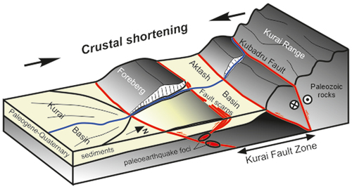
Shrinking of intermontane basins and expansion of their flanking ranges by reverse faulting and backthrusting in two counter-dipping systems is a typical mechanism of crustal shortening and mountain building in Central Asia. This mechanism is realized along the Kurai Fault Zone (southeastern Gorny Altai). Motions on two reverse fault systems maintained thrusting of the Kurai Range and the Kubadru Uplift on the Kurai Basin sediments and caused the growth of a foreberg before the mountain front. Forberg separates narrow Aktash Basin from the Kurai Basin. The paleoearthquakes were generated by reverse faults that delineate the foreberg. Analysis of the QuickBird satellite images, drone imagery, trenching, archaeoseismological research, radiocarbon dating, dendrochronology, and previous results show that eleven large (МW = 6.5–7.6) paleoearthquakes left traces as surface ruptures along the Kurai Fault Zone: twice before 7.5 ka BP, three events between 7.5 and 5.9 ka BP (7.0, 6.3, and 5.9–5.8 ka BP), one from 5.8 to 4.6 ka BP, four more at 4.6, 3.2, 1.5, and 1.3–1.2 ka BP, and the ultimate earthquake no older than 1450–1650 AD. The time difference between large earthquakes was from 200 to 1700 years. Surface faulting occurred mainly along the northern border of the foreberg where fault scarps are progressively younger northward and the Cenozoic sediments of the Aktash Basin thus become involved into uplift. GPR data to a depth of 12 m confirm the complex structure and slip geometry of the observed surface ruptures. The fault scarps are located < 1 km from the planned route of the gas pipeline from Russia to China, and the potential seismic hazard has to be taken into account in its design and construction.
GRAPHICAL ABSTRACT
Acknowledgments
E. Deev thanks the IPGG SB RAS (State Assignment FWZZ-2022-0001) for help in organizing field research. GPR survey was conducted in the frame work of the IGRAS State Task FMWS-2024-0005. Geoscan Gemini UAV, Agisoft Metashape software and a hardware for aerial photography processing was provided by the Geoportal MSU Share-Use Center. We wish to thank N. Semenyak and V. Kuznetsova A. for aid in field and laboratory dendrochronological studies. The authors acknowledge A. Korzhenkov for his valuable comments during the excavation and initial study of Trench 3.
Disclosure statement
No potential conflict of interest was reported by the author(s).
Supplementary material
Supplemental data for this article can be accessed online at https://doi.org/10.1080/00206814.2024.2333000