Abstract
The Arthur R. Marshall Loxahatchee National Wildlife Refuge overlays Water Conservation Area 1, a 580 km2 freshwater wetland remnant of the northern Everglades in Palm Beach County, Florida, USA. Changes in water quantity and quality have impacted the Refuge ecosystem. Ensuring appropriate management to maximize benefits for wildlife while meeting flood control and water supply needs is a refuge priority. The Simple Refuge Stage Model described herein supports these management decisions. The two-compartment model with a daily time step predicts temporal variations of water level in the refuge rim canal and interior marsh, based on observed inflows, outflows, precipitation and evapotranspiration. The model was used to evaluate various water management scenarios. The modelling approach applied herein may have utility in managing other wetland systems where over-bank flooding is a dominant mechanism, affecting hydrology and water quality.
1 Introduction and background
The A.R.M. Loxahatchee National Wildlife Refuge (Refuge) was established in 1951. It is bordered on the northwest by drained wetlands converted to agriculture known as Everglades Agricultural Area, and by urban development on the east, and on the southwest by the Water Conservation Area-2A. Construction of levees has had significant effects on the hydrology, vegetation, and wildlife in the Refuge (USFWS Citation2000). Changes in timing of water levels in the Refuge affect ecological factors, including wading bird feeding patterns, apple snail reproductive output, and alligator nesting. Similarly, changes in the spatial distribution of water depths alter the distribution of aquatic vegetation and tree islands. During the dry season, lower water levels increase the potential for fire, and damage vegetation, soils, and wildlife. Such conflicts between development and environmental protection are often inevitable and pose a challenge (Yevjevich and Starosolszky Citation1998).
Previous models of Refuge hydrology and water quality have been developed alone or as a part of the greater Everglades (Lin and Gregg Citation1988, Fitz and Sklar Citation1999, MacVicar and Lindahl Citation2000, Raghunathan et al. Citation2001, Welter Citation2002). However, none of these modelling efforts address current Refuge needs. The authors’ modelling efforts, including those reported below, build upon the understanding of previous modelling studies, and implement models addressing Refuge management decisions related to both quantity and timing of inflow and outflow.
2 Site description and available data
The Refuge landscape is an exceptionally flat complex mosaic of wetland community types, determined in part by water depth which is, in turn, influenced by differences in topography and micro-topography. These wetlands grade from wettest areas termed sloughs, to wet prairies, brush, and finally tree islands that are typically less than a metre above the surrounding marsh. The most recent marsh elevation data for the Refuge are available from topographic surveys by the United States Geological Survey (USGS) on a 400 m by 400 m grid (Desmond Citation2003). This survey finds that Refuge marsh elevations range from 5.64 m to 3.23 m NGVD29, with a mean marsh elevation of 4.62 m NGVD29. The Refuge has roughly a 1.61 cm per km downward north to south slope. Cross-sections of the perimeter canal that surrounds the marsh have an average bottom elevation of 3.24 m NGVD29.
A significant portion of the effort required to implement models is expended on data identification, compilation, and processing, and this particularly applies to the data-rich Everglades ecosystem. Meselhe et al.
Citation(2005) give a detailed description of the data acquisition effort supporting Refuge model development. They document selection of periods for calibration and validation, data sources, and quality assurance. Data compiled and evaluated include: Equation(1) marsh elevation and canal cross-section elevations; Equation(2)
hydrologic data including water levels and discharges through hydraulic structures; Equation(3)
meteorological data; and (4) water quality data. Based on these data, the period of study from 1 January 1995 to 31 December 2004 was selected. This period includes high quality data over a wide range of hydrologic conditions (wet, average, and dry). Much of the data used in this study were obtained from the South Florida Water Management District (SFWMD) database, DBHYDRO (www.sfwmd.gov/org/ema/dbhydro/).
3 Model development
3.1 Assumptions
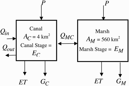
Development of the Simple Refuge Stage Model (SRSM) followed the strategy of starting with a simplified model, and adding complexity only if needed to obtain acceptable performance. Because both canal and marsh stages are required in applications, a two compartment model was selected. It is assumed that the canal and marsh operate as compartments with bi-directional exchange flow between them (). The simple modelling technique applied herein is reminiscent of the classical hydrological methods of level pool routing (Chow et al.
Citation1988) and simple modelling approaches by Rantz Citation(1982), Katopodis Citation(2005), or Kaleris Citation(1998). The model was implemented using Microsoft Excel with a daily time-step. Excel was chosen because of its widespread availability and ease of use. Other SRSM assumptions include: Equation(1) water surface stage within each compartment is flat, Equation(2)
marsh is characterized by a single average soil elevation of 4.62 m NGVD 29, Equation(3)
surface area of each compartment is constant. The marsh surface area was estimated to be 560 km2 and the canal surface area to 4.03 km2.
Figure 1 Schematic of compartmental structure of SRSM for Loxahatchee Refuge
3.2 Model formulation
Canal and marsh stages are calculated by integrating
3.3 Boundary conditions and observed parameters
Observed precipitation P data were obtained from nine gages within or in the immediate vicinity of the Refuge. The standard Thiessen polygons method was used to provide area-averaged rainfall over the Refuge. The average annual rainfall for the study period was approximately 132.3 cm/year. Evapotranpiration ET data for the Refuge are available from the ENRP (STA1W) site, where a lysimeter has been used. The daily averaged ET field measurements were used as a model input. It was observed that sites that go dry for even a few weeks out of the year have lower annual ET water losses (German Citation1999). Therefore, when the marsh stage approaches the average sediment elevation of 4.62 m NGVD 29, the measured potential ET is reduced by a depth-dependent factor (Arceneaux et al. Citation2007). Other models, including SWAT (Arnold et al. Citation1998) use a similar approach. This approach reduced the average annual ET from 132.33 to 117.60 cm/year.
There are 19 inflow and outflow hydraulic structures located around the perimeter canal, which play an important role in water management. Some of the structures were not in operation during the complete period of study (Waldon Citation2005). The inflows and outflows into/from the perimeter canal were aggregated into a total daily flow time series that was used as an input to the water budget model. For the study period, the annual average structure inflow and outflow to/from the Refuge were 742 and 709 hm3, respectively. The model was set up to optionally calculate outflows using the Refuge water regulation schedule as an alternative to using historic outflow records. The Refuge regulation schedule is administered by the USA Corps of Engineers Citation(1994), Jacksonville District, and is designed to regulate the water level through controlled water releases to maximize benefits related to flood control, water supply, and saltwater intrusion outside the Refuge, while also maximizing benefits for fish and wildlife within the Refuge. The Refuge regulation schedule is described in the Comprehensive Conservation Plan for the Refuge (USFWS Citation2000).
3.4 Estimated parameters
The bi-directional flow between the marsh and canal is assumed to be controlled by the stage difference between the two compartments. This was calculated using the power law model frequently used in wetland applications (Kadlec and Knight Citation1996). This flow model is similar to a weir equation, with the discharge dependent on marsh surface water depth H as
4 Model calibration and validation
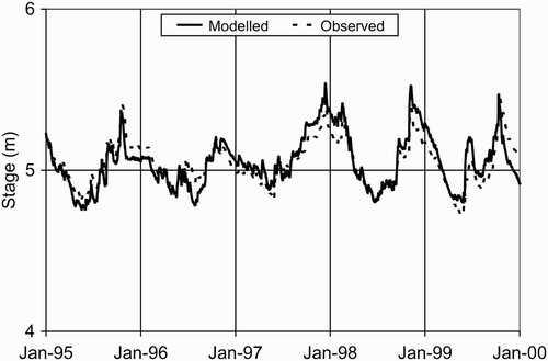
The model was calibrated for the 5-year period 1 January 1995 to 31 December 1999. The modelled marsh stages were compared to the average stages of two USGS gages near the centre of the Refuge. Over the study period, mean, maximum and minimum daily average marsh stages were 5.01, 5.49, and 4.55 m NGVD 29, respectively. The USGS gage 1-8C located in the perimeter canal was used for calibration of the modelled canal stages. For this gage, the observed mean daily average stage over the period of study ranged from 3.68 to 5.54 m, with a mean of 4.98 m, ranging from 5.54 to 3.68 m NGVD 29. For statistical reasons, a value of 4.27 m NGVD 29 was used if the modelled or observed stages fell below 4.27 m NGVD 29. This substitution was done because the model is intended to model higher canal stages, and this constraint prevents stages below 4.27 m from dominating statistical evaluations. This canal stage limit supports the objective of maintaining model simplicity, while permitting the model calibration within the stage range of greatest interest.
Calibration of the SRSM involved adjustment of model parameters to fit the observed stages during the 5-year period from 1995 to 1999. These parameters include the transport coefficient C, canal and marsh seepage rate constants, the ET reduction factor; and the depth at which ET is reduced. A sensitivity analysis was performed to identify the parameters with the most significant impact on the model performance and to determine the range of values for each of these critical parameters producing the best model performance while maintaining compatibility with previously published values for these parameters. The most sensitive parameter was found to be the depth at which ET is reduced. The sensitivity analysis also showed that the canal stage was sensitive to the transport coefficient C but the marsh stage was insensitive to this parameter. The seepage rate constants were calibrated for the canal and marsh as 0.042 per day and 0.00013 per day, respectively. These values are consistent with published estimates (Lin and Gregg Citation1988). Both the marsh and canal were sensitive to the canal and marsh seepage rate parameters. Additional details regarding the sensitivity analysis is found in Arceneaux et al. Citation(2007). Both the marsh and canal showed also some sensitivity to the canal and marsh seepage rate parameters. Over the calibration period, there was good agreement between the observed and modelled marsh () and canal stages (not shown). The model was unable to capture some of the low canal stages, suggesting that there may have been unrecorded water withdrawals. Statistical measures used to evaluate the model performance () include bias (that is, average error), root mean square error (RMSE), standard deviations of the modelled data, observed data, and error between the modelled and observed data, correlation coefficient R, coefficient of determination, R 2, variance reduction, and the Nash–Sutcliffe Efficiency (Nash and Sutcliffe Citation1970). The model performance for predicting marsh stage was better than for canal stage. The model slightly overestimated the observed stage in both the canal and marsh.
Table 1 Calibration and validation statistics for marsh and canal stage
Figure 2 Modelled and observed marsh stages for calibration period
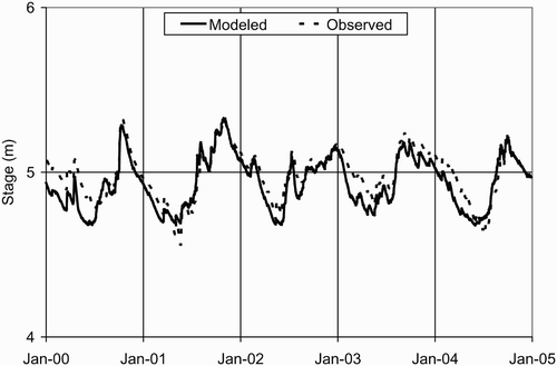
The model was validated for the 5-year period from 2000 to 2004. Both the modelled canal and marsh stages are in good agreement with observations (, ). During the validation period, the model underestimates the observed data (negative bias) in both the canal and the marsh. Although both calibration and validation biases are acceptably small, the validation and calibration biases are of the opposite sign. Contrary to the calibration results, the model captured the low stage events in the canal during validation, supporting the conjecture that there were unrecorded outflow events during the earlier calibration period.
Figure 3 Modelled and observed marsh stages for validation period
5 Applications
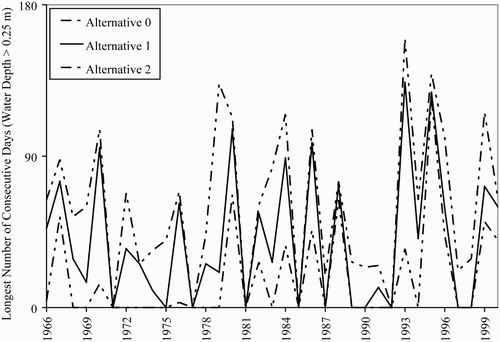
The validated model was used to compare alternative management scenarios. For example, one recent proposal of the Everglades Agricultural Area Regional Feasibility Study (EAARFS) would reduce Refuge inflow through diversion (A.D.A. Engineering and SFWMD Citation2005). None of the EAARFS modelling explicitly addressed the effects of alternative inflow volume changes on the “downstream” Everglades marshes that receive the STA discharges. The model was used to assess the impacts of proposed alternatives. Water levels were simulated for a consecutive 36-year period, demonstrating the capability to efficiently model multi-decadal periods. This simulation predicted the digression of water levels resulting from diversion. The simulation considered two major alternatives termed Alternatives 1 and 2, relative to a no project alternative termed here Alternative 0. Both Alternatives 1 and 2 reduce the annual volume of inflow to the Refuge relative to Alternative 0. Using the estimated stages in the marsh, the hydro-periods were estimated to determine the number of days when the Refuge water depth was larger than 0.25 m. The purpose of determining the inundation periods is to provide ecologists with a basic understanding of the changes in water levels and the effects they have on wildlife and plants in the Refuge. The total annual inundation periods refer to the total number of days for all three alternatives ().
Figure 4 Total number of days with water depth in Refuge marsh larger than 0.25 m
6 Conclusions
The Simple Refuge Stage Model is an efficient tool for multi-decadal simulations. The model can test the response of a Refuge to a broad suite of alternative long-term management scenarios that could be feasibly examined using complex spatially explicit models. Application of this model is also limited by its spatial aggregation. The model reliably predicts temporal variations of water levels and flows between the canal and marsh. These flows can be input into a constituent transport and transformation model to study eutrophication and other issues related to contaminants that enter the marsh from the canal. The model demonstrates that using a simple equation such as a power law model to estimate flow between the canal and marsh, coupled with a highly simplified geometry, provides an adequate description.
During extremely low canal stages, the model estimation of canal stage is limited by its structure and assumptions. However, it recovers well if the canal stage returns to normal levels. Future improvement to the model may include dividing the single marsh compartment into multiple cells. While these improvements may expand the model range, the current simple two-compartment structure is well suited for applications. The success of the simplified modelling approach taken here suggests that a similar approach could be of value in modelling the wetland stage in many riparian wetlands that are periodically inundated and drained by adjacent streams or canals.
Notation
| A | = |
surface area |
| C | = |
transport coefficient |
| E 0 | = |
average marsh ground elevation |
| E | = |
stage |
| ET | = |
evapotranspiration |
| G | = |
seepage |
| H | = |
differential head |
| P | = |
precipitation |
| Q in | = |
external (boundary) inflow |
| Q out | = |
outflow |
| Q MC | = |
bi-directional exchange flow between marsh and canal |
Subscripts
| C | = |
canal |
| M | = |
marsh |
Related Research Data
References
- A.D.A. Engineering and SFWMD . 2005 . Everglades Agricultural Area regional feasibility study , West Palm Beach, FL : South Florida Water Management District . (http://www.sfwmd.gov)
- Arceneaux , J. , Meselhe , E. A. , Griborio , A. and Waldon , M. G. 2007 . The A.R.M. Loxahatchee National Wildlife Refuge water budget and water quality models . Report No. LOXA-07-004 (http://loxmodel.mwaldon.com)
- Arnold , J. G. , Srinivasan , R. , Muttiah , R. S. and Williams , J. R. 1998 . Large area hydrologic modeling and assessment 1: Model development . J. Am. Water Res. Assoc. , 34 ( 1 ) : 73 – 89 .
- Chow , V. T. , Maidment , D. R. and Mays , L. W. 1988 . Applied hydrology , New York : McGraw-Hill .
- Desmond , G. 2003 . South Florida high-accuracy elevation data collection project , FS-162-96, U.S. DOI, USGS, Reston VA (http://sofia.usgs.gov/publications/fs/162-96/)
- Fitz , H. C. and Sklar , F. H. 1999 . “ Ecosystem analysis of phosphorus impacts and altered hydrology in the Everglades: A landscape modeling approach ” . In Phosphorus biogeochemistry in subtropical ecosystems , 585 – 620 . Boca Raton, FL : Lewis .
- German , E. R. 1999 . “ Regional evaluation of evapotranspiration in the Everglades ” . In Proc. 3rd Intl. Symp. Ecohydraulics Salt Lake City, UT (http://sofia.usgs.gov/publications/papers/evalET/index.html)
- Kadlec , R. H. and Knight , R. L. 1996 . Treatment wetlands , Boca Raton, FL : Lewis .
- Kaleris , V. 1998 . Quantifying the exchange rate between groundwater and small streams . J. Hydraulic Res. , 36 ( 6 ) : 913 – 932 .
- Katopodis , C. 2005 . Developing a toolkit for fish passage, ecological flow management and fish habitat works . J. Hydraulic Res. , 43 ( 5 ) : 451 – 457 .
- Lin , S. and Gregg , R. 1988 . Water budget analysis: Water conservation area 1. DRE-245 , West Palm Beach, FL : South Florida Water Management District .
- MacVicar , T. K. and Lindahl , L. J. 2000 . The “Natural System Model” and its application in support of Everglades restoration , Florida Department of Agriculture and Consumer Affairs, and Everglades Agricultural Area Environmental Protection District .
- Meselhe , E. A. , Griborio , A. G. , Arceneaux , J. C. , Chunfang , C. X. and Gautam , S. 2005 . Hydrodynamic and water quality modeling for the A.R.M. Loxahatchee National Wildlife Refuge, Phase 1: Preparation of data . Report LOXA05-014 (http://sofia.usgs.gov/lox_monitor_model/advisorypanel/data_acq_report.html)
- Nash , J. E. and Sutcliffe , J. V. 1970 . River flow forecasting through conceptual models 1: A discussion of principles . J. Hydrol. , 10 ( 3 ) : 282 – 290 .
- Raghunathan , R. , Slawecki , T. , Fontaine , T. D. , Chen , Z. , Dilks , D. W. , Bierman , V. J. Jr. and Wade , S. 2001 . Exploring the dynamics and fate of total phosphorus in the Florida Everglades using a calibrated mass balance model . Eco. Modell , 142 ( 3 ) : 247 – 259 .
- Rantz, S.E. (1982). Measurement and computation of streamflow 2: Computation of discharge. Geological Survey Water-Supply Paper 2175. United States Government Printing Office, Washington (http://water.usgs.gov/pubs/wsp/wsp2175/)
- USA Corps of Engineers . 1994 . Environmental assessment: Modification of the regulation schedule WCA No. 1 , Jacksonville, FL : USCE .
- USFWS . 2000 . A.R.M. Loxahatchee National Wildlife Refuge comprehensive conservation plan , Boynton Beach, FL : US Fish and Wildlife Service . (http://loxahatchee.fws.gov)
- Waldon , M. G. 2005 . Timeline of historic and environmental events relevant to the hydrology and water quality in the A.R.M. Loxahatchee National Wildlife Refuge , Boynton Beach, FL : USFWS . (http://mwaldon.com/research/Refuge-timeline.doc)
- Welter , D. 2002 . Loxahatchee National Wildlife Refuge HSE model , West Palm Beach, FL : South Florida Water Management District .
- Yevjevich , V. and Starosolszky , Ö. 1998 . Controversies between water resources development and protection of the environment . J. Hydraulic Res. , 36 ( 1 ) : 135 – 138 .