
ABSTRACT
We explore changes to settlement and mobility in the northern Raja Ampat Islands (Waigeo, Gam, and Batanta) over the past five centuries, a time when speakers of several Austronesian languages were moving throughout the archipelago. The evidence shows: (1) some settlement relocations were rapid, occurring within a generation, while other settlements remained fixed for hundreds of years; and (2) there were numerous clan and family scale movements that led to high levels of intermarriage between language groups and settlements. The results demonstrate that far from being a place of stasis caught between the worlds of Maluku and New Guinea, Raja Ampat settlement and mobility were highly dynamic. This dynamism prompts us to rethink the relationship between today’s settlement locations, their language affiliations, and the meta-narratives about their recent population histories. We propose that the deeper past of Raja Ampat may have also been characterized by dynamic movement and social flux.
ABSTRAK
Kami mengkaji perubahan permukiman dan mobilitas penduduk di Kepulauan Raja Ampat bagian utara (Waigeo, Gam, dan Batanta) selama lima abad terakhir, kurun waktu ketika penutur beberapa bahasa Austronesia berpindah ke seluruh nusantara. Bukti-bukti menunjukkan: (1) beberapa relokasi permukiman berlangsung cepat, terjadi dalam satu generasi, sementara ada permukiman lainnya berrtahan tidak pindah selama ratusan tahun; dan (2) banyaknya perpindahan suku dan keluarga telah mengakibatkan tingginya tingkat perkawinan campur antara penutur bahasa yang berbeda dan permukiman. Hasil penelitian menunjukkan bahwa wilayah tersebut tidak statis, meskipun terapit di antara wilayah Maluku dan Papua. Sebaliknya, perpindahan pemukiman dan mobilitas penduduk di Raja Ampat sangat dinamis. Dinamika ini membuat kita perlu memikirkan kembali hubungan antara lokasi pemukiman yang ada saat ini, afiliasi bahasa mereka, dan meta-narasi tentang sejarah penduduk akhir-akhir ini. Kami berpendapat bahwa di masa lalu wilayah Raja Ampat mungkin juga ditandai oleh pergerakan penduduk dan perubahan sosial yang sangat dinamis.
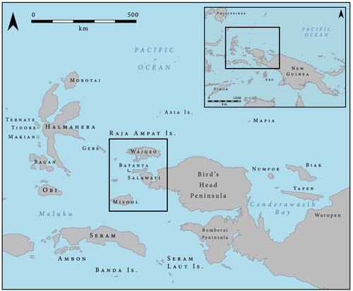
The Raja Ampat Islands, lying just off the Bird’s Head of New Guinea, provide an ideal setting in which to explore the temporal dynamics of settlement in the far western Pacific (). Indeed, the islands have been inhabited for over 50,000 years and were important locations for the initial peopling of the Pacific, as well as for later pulses of movement and migration over the past 15 millennia or more.Footnote1 Today, the northern islands of this archipelago – Waigeo, Gam, and Batanta, along with hundreds of satellite islands – are home to coastal communities who speak several distinct Austronesian languages. They variably follow Christianity, Islam, and local customs, and make use of both the nearby reefs and lowland tropical forests for settlement, subsistence and, increasingly, ecotourism.Footnote2 Despite this diversity, the Raja Ampat Islands are poorly documented in the historical and anthropological literature. In the early European accounts that do exist, some Raja Ampat communities are described as being outward facing and eager to trade while others are depicted as reclusive and hostile.Footnote3 In almost all accounts, however, the Raja Ampat Islands have been cast as relatively static, at the periphery between two island centres – Indonesia to the west and New Guinea to the east. This view was established because the islands were ostensibly subject to the authority of rajas who paid tribute to the Sultan of Tidore at the time of Dutch expansion in the East Indies from the 17th to 19th centuries.Footnote4 Due to their lack of spices and other coveted resources, Raja Ampat and much of western New Guinea were not a subject of interest for competing colonial powers until the very end of the 19th century, at which point the Dutch annexed New Guinea from 141° East as a buffer to British incursions into the East Indies.Footnote5 As such, the history of the islands has been fixated on the influence that Maluku and the Dutch had in the region, rather than on people of Raja Ampat themselves.
Figure 1. Location of the Raja Ampat Islands off the coast of New Guinea.
When researchers began to visit Raja Ampat in greater numbers at the end of the 19th century, their focus was primarily on natural history rather than the human settlement of the region.Footnote6 As such, these narratives tend to focus on interactions between the fieldworker and their local assistants, with passing reference to the nature of the wider Raja Ampat community. Even when large scientific expeditions began to visit western New Guinea in the early 20th century, they set off from ports in Batavia or Ambon and usually bypassed the Raja Ampat Islands.Footnote7 As such, we know little about the human history of the Raja Ampat Islands prior to the late 20th century, when the archipelago was annexed as part of Irian Barat by Indonesia.
This article draws upon linguistic, ethnographical, historical, and archaeological information to reimagine the recent human history of settlement in the Raja Ampat Islands. In so doing, we provide a case study that challenges the idea that small rainforested islands are simply lying in stasis between the orbit of larger insular political and economic systems. Rather, the rates of settlement change evidenced in Raja Ampat even within the past few centuries – sometimes rapid and other times gradual – indicate that the islands were internally dynamic and acted as a crucial node for movement and exchange between Island Southeast Asia and the Pacific, with Raja Ampat shaping the trajectory of these emerging connections. Moreover, if recent centuries are anything like a guide for archaeologists, linguists, and historical anthropologists, the deeper past of Raja Ampat could likewise be characterized by these kinds of dynamic movement and social flux.
Language Groupings, Contact, And Movements
Within Raja Ampat, people identify with several distinct communities. On Waigeo, Maˈya has come to be used as a common term to refer to the indigenous peoples, with several sub-groups self-identifying as Ambel, Langganyan, Wawiyai, and Kawe. Indigenous Maˈya groups also live on Salawati (known as Kamuna, Fiayawat, Bedehen, Tipim, Waili, and Kares), on Misool (known as Matbat, Maltow, and Biga), and on Batanta (known as Batta). Biak people are distributed throughout the archipelago but consider themselves distinct from the indigenous groups, as well as recent Malay, Malukan, and Javanese arrivals.
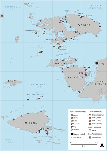
The present-day linguistic situation of Raja Ampat is shown in . Today, there are seven indigenous languages spoken in and around Raja Ampat (hereinafter ‘the Raja Ampat languages’): Ambel (on Waigeo, around Mayalibit Bay and on the north coast); As (in Asbaken, Mega, and Malaumkarta villages on the northwest coast of the Bird’s Head); Batta (southern Batanta); Biga (in Biga village, southeast Misool); Matbat (across Misool); several dialects of Salawati (across Salawati Island); and Maˈya. In linguistic classifications, and in contrast with local use of the term, Maˈya is a distinct language, divided into three dialects on Waigeo – Langanyan (Mayalibit Bay, spoken at Lopintol and Arway),Footnote8 Wauyai (Kabui Bay, spoken at Wawiyai), and Kawe (western Waigeo, spoken at Selpele and Saleo) – with two further dialects spoken on Salawati and Misool.Footnote9 The Raja Ampat languages all belong to the South Halmahera–West New Guinea (SHWNG) subbranch of the Austronesian language family, which comprises around 40–45 languages spoken in northwest New Guinea, Raja Ampat, and southern Halmahera. Within SHWNG, the Raja Ampat languages group with the SHWNG languages spoken in Halmahera, in a branch called Raja Ampat–South Halmahera (RASH).Footnote10
Figure 2. Languages spoken around the Raja Ampat islands. Compiled from information in Arnold, ‘Four undocumented languages of Raja Ampat’, 25–43.
The RASH branch probably represents an early westwards movement of SHWNG speakers from the proto-SHWNG homeland in Cenderawasih Bay, some time after 3500 years ago.Footnote11 This group possibly first settled in Raja Ampat, thought to be the homeland of proto-RASH, before diverging further.Footnote12 The RASH languages of Halmahera form a discrete subbranch called South Halmahera, and were again likely an early movement from the proto-RASH homeland. Gebe, classified as a South Halmahera language, is today spoken on Gebe and Yoi islands, and historically was spoken on Gag Island, all located between Raja Ampat and Halmahera.Footnote13 Their location suggests there was a subsequent eastwards movement from the proto-South Halmahera homeland on the central–eastern coast of Halmahera.Footnote14
The internal subclassification of the Raja Ampat languages is given in . As shown here, the Raja Ampat languages do not form a discrete subgroup within RASH: Ambel and As are classified as primary branches of proto-RASH, and the remaining Raja Ampat languages (Biga, Batta, Matbat, and the Maˈya and Salawati dialects) are classified in a single subgroup called ‘Raja Ampat’.Footnote15 The implication of this subclassification for population movements is that there was an early divergence of these three branches, probably around the same time as speakers of proto-South Halmahera migrated westwards. Based on cognate vocabulary referring to fauna found only on the islands to the south of the Sorong fault that runs between Batanta and Salawati (such as cassowaries and leeches), it is likely that the homeland of proto-Raja Ampat was on Salawati or Misool, and the homeland of proto-Ambel was Waigeo, where the language is spoken today. Whether the divergence of proto-Raja Ampat and proto-Ambel was caused by speakers of proto-Ambel moving northwards from a more southernly homeland (for example, Salawati or Misool), speakers of proto-Raja Ampat moving southwards from a more northernly homeland (for example, Waigeo), or speakers of proto-Ambel moving northwards and speakers of proto-Raja Ampat moving southwards from a central homeland (for example, Salawati), is at present unknown. The As language is now moribund, but was recently spoken on the northwest coast of the Bird’s Head mainland. However, although oral traditions indicate that these settlements are only a few centuries old, the ultimate origin of the As speakers is unclear: different authors suggest that the As came from Halmahera, Salawati, or Gag,Footnote16 and the linguistic data do not shed any further light on the topic.
Figure 3. Proposed phylogeny of the Raja Ampat languages, following Arnold in ‘The Diachrony of Word Prosody’.
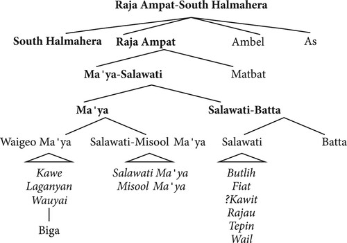
Following the divergence from proto-RASH, proto-Raja Ampat then began to break up further. The first split was between speakers of Matbat and the rest of the proto-Raja Ampat speakers; the latter developed into proto-Maˈya-Salawati. Proto-Maˈya-Salawati then diverged into proto-Salawati-Batta, spoken on Salawati, and proto-Maˈya, spoken on Waigeo. Proto-Salawati-Batta latterly dissolved into the string of closely related Salawati dialects, with speakers of what would become Batta migrating northwards to Batanta. In accordance with oral traditions, proto-Maˈya may have been spoken in central Waigeo. The origin myth of the Maˈya, which will be described in more detail below, may be correlated with the divergence of proto-Maˈya into the present-day dialects.Footnote17 Maˈya later became the language of the rajas, and the local lingua franca prior to the arrival of Papuan Malay.Footnote18 Linguistically, Biga is an innovative offshoot of the Maˈya dialects spoken on Waigeo.Footnote19
Speakers of Biak have moved westwards from Cenderawasih Bay to Raja Ampat in recent centuries.Footnote20 Being a non-RASH SHWNG language, Biak is today the dominant language in a number of villages around Waigeo, Batanta, Kofiau, and Misool. It is divided into several dialects by its speakers: Beser (or Betew) Biak, spoken on Gam and in the small islands around western Waigeo, Pam Island, Kri and Mansuar, Kofiau, and the Nusela group; Wardo Biak spoken on the east and north coast of Waigeo; Usba Biak spoken off the north coast of Waigeo and in the Ayau Islands; and Kafdaron Biak spoken along the north coast of Batanta. Many villages on Gam, western and eastern Waigeo, Batanta, and Kofiau were founded by Biak speakers, while others around Mayalibit Bay and the north coast of Waigeo are shared with Ambel speakers.Footnote21 This has resulted in substantial lexical and grammatical transfer, particularly from Biak into Ambel.
There are, additionally, two non-Austronesian languages spoken in Raja Ampat: Seget, a member of the West Bird’s Head family, is spoken in the east and south of Salawati; and Duriankari, which was until recently spoken in a single village in the south of Salawati, is thought to be related to Inanwatan on the south coast of the Bird’s Head.Footnote22 Both of these groups represent recent migrations into the Raja Ampat islands. There is strong linguistic evidence that non-Austronesian languages were spoken in the archipelago before the arrival of Austronesian speakers. These languages are now extinct, but have left traces of contact in the Raja Ampat languages. For example, all of the Raja Ampat languages have lexical tone – a feature that is very unusual in the Austronesian family, but fairly common in the non-Austronesian languages of New Guinea. This suggests that speakers of a tonal non-Austronesian substrate were involved in tonogenesisFootnote23 in the Raja Ampat languages, as they acquired and eventually shifted to the Austronesian languages of the incomers.Footnote24 Morphosyntactic innovations,Footnote25 such as the development of an unusual possessive system in Ambel and Salawati, and animacy distinctionsFootnote26 in several of the languages, have also been ascribed to contact with non-Austronesian languages.Footnote27 These kinds of structural changes are typically associated with childhood bilingualism lasting several generations, suggesting there were stable periods of intermarriage between the Austronesian and non-Austronesian speaking groups. Finally, all of the Raja Ampat languages have substantial non-Austronesian lexicons, possibly loanwords from the non-Austronesian languages formerly spoken in the archipelago.Footnote28 The precise timing of these interactions between the Austronesian and non-Austronesian groups of Raja Ampat is difficult to extract from the linguistic data, and probably lasted at least several centuries. However, as these features are not found in the South Halmahera branch of RASH, and the resulting systems are not cognate within the Raja Ampat languages (for example, there were multiple innovations of tone), the contact events that led to their development most likely post-dated the divergence of proto-RASH.
Demography, Settlement Patterns, And Land Tenure
Today, Raja Ampat is sparsely populated by fewer than 50,000 people.Footnote29 That equates to about six people per square kilometre; as a point of contrast, Timor Leste is home to about 90 people per square kilometre. The archipelago is politically part of Papua Barat Daya, Indonesia, and became its own regency (Kabupaten Raja Ampat) in 2002, with local political administrators based in the town of Waisai. This regency is currently sub-divided into 17 administrative districts, each containing several coastal villages ranging between about 150–1000 people. Census records suggest population densities were even lower during the early 20th century ().
Table 1 Population census of the Raja Ampat Islands during the late 20th and early 21st centuries.Footnote30
Early European records substantiate these approximate ranges. During 1581–2, a Portuguese soldier named Roxo de Brito described small populations of several thousand people on each island, subject to the authority of the rajas of Misool and Waigeo.Footnote31 For instance, on Misool there was reportedly a raja with control over 4000–5000 men, and around Waigeo the raja had 1000 men at his disposal.Footnote32 Meanwhile, Torobi Island near Kofiau was inhabited by a lesser raja and about 2000 men.Footnote33 Roxo de Brito also describes a large and prosperous kingdom subject to the Raja of Waigeo. This was likely located on the west coast of Salawati.Footnote34 By 1860, the naturalist Hermann von Rosenberg estimated that the Raja Ampat population comprised perhaps 6000 people living on Waigeo, 6000 on Salawati, and another 2000 on Misool, with most settlements home to no more than 100 people.Footnote35 At this time, the north coast of Batanta was not permanently inhabited, but was administered by the Raja of Salawati and only periodically visited by other islanders for fishing, collecting sea cucumbers, or hunting turtles.Footnote36 This suggests that today’s Biak settlements along the north coast of Batanta are no more than a century and a half old and are the result of settlers moving to the area to access trade networks, resources, and land. Biak people called Waigeo saprop mahi (the land of birds) and the Raja Ampat area seems to have featured as an important place for Biakers to capture bird-of-paradise.Footnote37 Indeed, many Biak speakers dominated the sea routes around the Bird’s Head in the 19th century by trading and raiding, often as oarsmen for Tidorese hongi raids, from Cenderawasih Bay and the Dampier Strait between Waigeo and Batanta, all the way to Misool and Seram in the south.Footnote38
Raja Ampat’s exclusively coastal settlement pattern is a very new tradition and, in the recent past, the population was clearly divided. At the start of the 18th century, the majority of Misool’s population was said to live inland and practise local beliefs but recognized the power of the coastal groups who lived in stilt villages and followed Islam.Footnote39 Similarly, the coasts of Waigeo were occupied by Islamic groups of ‘mixed origin’,Footnote40 but there were also groups living inland that did not occupy fixed settlements and practised mobile foraging.Footnote41 By the mid-19th century these inland groups around Mayalibit Bay had been brought together into static settlements by the Tidorese sultanate. Von Rosenberg described the inland groups as ‘indigenous Papuans’ that were subject to the coastal rajas and lived in small scattered settlements in the rainforest.Footnote42 At the end of the 19th century, de Clercq noted that the western Waigeo groups living around Kabui Bay and Selpele Peninsula also lived in the interior.Footnote43 However, by the 1920s all of the Waigeo groups were described as being people of the sea.Footnote44 Similarly, some groups on Misool and Salawati lived in the interior until the mid to late 20th century.Footnote45 The translocation of inland groups to the coast was likely related to Tidorese and Dutch methods of control, whereby people were moved from the rainforest to the coast to facilitate administration, the exaction of tribute, and the extraction of goods and services.Footnote46 Alongside this, many of these movements may have been gradual and voluntary, reflecting the increased safety afforded by the Dutch prohibition on Tidorese hongi raids in 1861 and slaving in 1879,Footnote47 and growing economic and social incentives offered by trade and marine resources, following 1667 when the Dutch East India Company (Vereenigde Oostindische Compagnie, VOC) granted Tidore monopoly over trade with Raja Ampat,Footnote48 and in the late 19th and early 20th centuries as cash cropping and inter-island mobility increased due to the introduction of Dutch steam ships.
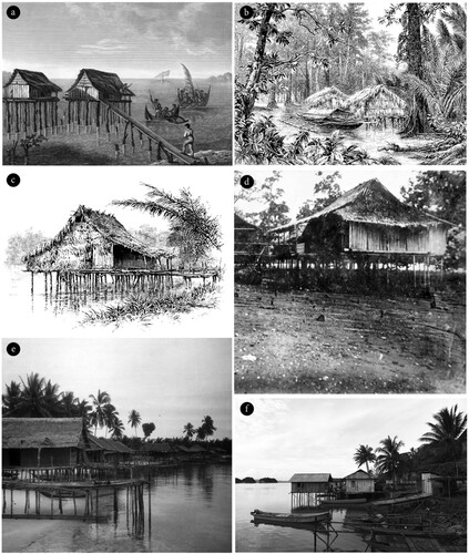
Observers in the early 20th century noted that the coastal groups, which included those whose ancestors formerly lived inland, were gentle, timid, and not physically robust, following a broadly patrilocal settlement pattern and polygamous exogamous marriage system.Footnote49 They lived within a few kilometres of the sea and had an economic focus on littoral and pelagic resources, agroforestry, and horticulture. Many of their houses were situated on stilts over the intertidal zone (), and refuse would accumulate below these structures. As Alfred Russel Wallace observed: ‘the chief food of the people was evidently shell-fish, since great heaps of the shells had accumulated in the shallow water between the houses and the land, forming a regular “kitchen-midden” for the exploration of some future archaeologist’.Footnote50 Local gardens included sago stands, and patches of leafy greens, sweet potatoes, sugar cane, and yams.Footnote51
Figure 4. Stilt houses around Raja Ampat: (a) settlement on the north coast of Waigeo illustrated by Friedrich Schroeder and J. Arago during voyage of the corvettes S.M. l‘Uranie and S.M. la Physicienne; (b) houses in Mayalibit Bay, illustrated during the cruise of the Marchesa in 1883; (c) house on the south coast of Waigeo, illustrated during the same voyage; (d) probably Lamlam or Missigit on the north coast of Waigeo, photographed in 1917 by crew of the SMS Wolf, a German armed merchant raider; (e) houses on the Waigeo coast, c. 1920; (f) Wawiyai village, Kabui Bay, Waigeo 2018.Footnote53
For these coastal groups, the sasi system regulated access to different areas for gardening, hunting, and collecting, both on land and sea. Sasi means ‘taboo’ in Ambel, and similar systems of resource tenure and control are used throughout eastern Indonesia and western New Guinea.Footnote52 The system provided temporary access to different animals, plants, and raw materials that could be targeted in specific catchments during wet seasons. In this way, land and sea were not commoditized, but access to the environment’s potential for providing food and material was carefully controlled as a way to ensure resource sustainability, maintain political control, and manage conflict.Footnote54 Sasi was regulated by the village head and senior clan leaders who allowed resources to be opened or closed for extraction by locals; outsiders could also seek access to land and resources, but reciprocity was expected.Footnote55
Changing Toponyms And Settlement Locations
Early European records provide important information about the rate at which settlements were founded, renamed, abandoned, and then built anew over the past 500 years. Moreover, as Peter Lape demonstrates for the Banda Islands,Footnote56 early maps can be a useful source to retrace settlement patterns on the centennial and decadal scale. The Raja Ampat Islands may have first been recorded in 1526 by Jorge de Menezes, then Portuguese governor of Maluku, who anchored at ‘Isla Versija’, which was either Warsia on the north coast of New Guinea, or the island of Waigeo.Footnote57 One year later, a Spanish ship captained by Garcia Jofre de Loaìsa Miguel anchored near Tidore and reconnaissance of the region identified ‘las islas de las Papuas’ to the east, probably referring to Gebe, Gag, Waigeo, Gam, and Batanta, among other islands.Footnote58 These islands were referred to as sup i papwa in Beser Biak and have probably given their name to what is now ‘Papua’.Footnote59 Misool was illustrated on Dutch and French charts from the late 17th century but the more northerly islands were glossed as the Papuan Islands,Footnote60 and Waigeo Island was not incorporated until the early 18th century.Footnote61
A Dutch expedition of 1705–6 visited Salawati, Waigeo, and the islands of Sagewin Strait between Salawati and Batanta.Footnote62 The expedition noted about 15 houses at Kabilol in Mayablibit Bay where the Raja of Waigeo lived.Footnote63 Wagaimerok was sited near the entrance to the bay,Footnote64 Warjo was located on the east coast of Waigeo,Footnote65 and Umpain, which consisted of four settlements, was on the west coast.Footnote66
Thomas Forrest, a navigator for the British East India Company, visited Raja Ampat in 1774–5. In December 1774, he first dropped anchor at Gag Island, which was uninhabited and relatively barren, but acted as a steppingstone for seafarers moving between Maluku and Raja Ampat.Footnote67 In the western islands, around Manyaifun and Tamako Island,Footnote68 lived a community of Muslims.Footnote69 While passing the Selpele Peninsula of western Waigeo, Forrest documented a settlement with his spyglass called Ilkalio.Footnote70 From there his ships passed between Kawe Island and Waigeo,Footnote71 before turning eastwards along the north coast of Waigeo, stopping in Fofak Bay.Footnote72 Although he did not encounter settlements at Fofak, he recorded sago groves and patches of grassland probably caused by forest clearance, and was told by his Malukan crew that the inhabitants lived in secretive locations and would shoot arrows at travellers.Footnote73 From the western part of Fofak Harbour, people would carry their canoes through the bush to Mayalibit Bay, which is today about a half day’s walk, and within Mayalibit was said to be a large number of settlements that were continually at war with one another.Footnote74 On his return from New Guinea, Forrest passed by small settlements at KabareFootnote75 and Wargow, and recorded a small number of stilt houses on the east coast of Lawak Island.Footnote76 To the northwest, Forrest recorded the Ayau Islands,Footnote77 where the headmen were ‘Papuan’, reflecting their Biak heritage.Footnote78
Several French expeditions further recorded the northern coast of Waigeo, led by De Freycinet in 1789, D’Entrecasteaux in 1794, and Duperrey in 1823.Footnote79 The latter voyage in particular recorded the location of coconut groves, huts, and a stilted spirit house in the east of Fofak Bay,Footnote80 where 20th-century maps note the location of Missigit settlement and a ‘mosque’.
Since the mid-19th century, the number of charts published on the Raja Ampat Islands steadily increased, especially under Dutch administration and during the Second World War ( and ). Although there are substantial inaccuracies and gaps in most early European charts, it is clear that some settlements around Waigeo such as Kabare, Beo, and Go have remained, in name and location, relatively fixed throughout the last two or three centuries, while others, such as Missigit and the original Waisai, have been abandoned, and others again like Kapidiri, Kalitoko, and Warsambin have been founded within the last century.Footnote81 Cheesman recounts one reason for such relocations:Footnote82 one of the rajas of Waigeo used to reside at Fafak, a former settlement on the north coast of Mayalibit Bay, east of Go village (see , 1935), but when that raja left Waigeo, the Islamic part of the community moved to Fofak Bay to the north. The remainder of the community moved to Go, although one family founded Waifoi at that time. These kind of power shifts, with important implications for how settlements operated within the broader social landscape, seem to have been relatively frequent ().
Figure 5. Changing settlements locations and toponyms based on historical maps, part 1.Footnote83
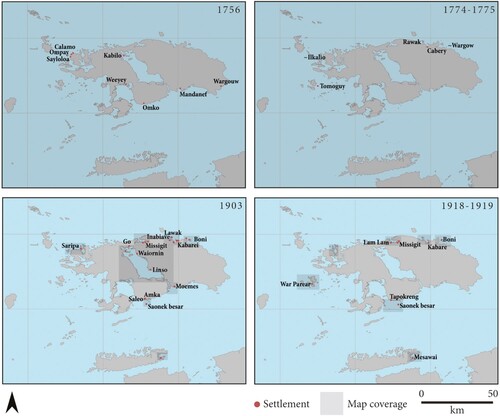
Figure 6. Changing settlements locations and toponyms based on historical maps, part 2.Footnote87
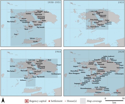
Table 2. The seat of the Raja of Waigeo, recorded by available European sources.Footnote90
Oral Traditions And Recent Clan Movements
Oral traditions offer important insight into past population movements and contact between settlements, providing a chronological time frame similar to that of European accounts but from a very different perspective. For instance, some Ambel stories may be residual memories of when people inhabited the interior of Waigeo. The Ambel reportedly learned bintaki, a fish poisoning ritual, several generations ago from kabyo,Footnote84 who are said to be evil spirits that inhabited the interior of the island and often had an antagonistic relationship with the coastal groups.Footnote85 Many words in the song recited during the ritual are not Ambel and may derive from a now extinct non-Austronesian language.Footnote86 Similarly, stories of ‘orang gi’, who are said to have short stature and dark skin, may reflect a similar, but distinct, population in the interior of Waigeo.Footnote88
Maˈya origin stories suggest some of their ancestors derive from the interior of Waigeo. One version from the Maˈya speakers at Samate on north Salawati tells of a woman named Boki Deni finding seven eggs;Footnote89 six of these hatched into four men, a woman, and a spirit.Footnote99 The final egg remains unhatched and is cared for at a sacred location along the Wawage (Dusun) River that outflows into Kabui Bay. Three of the men then became the rajas of Waigeo, Salawati, and east Misool,Footnote100 while the fourth man moved to Seram and the woman, Pintake, became pregnant and moved to Cenderawasih Bay. There, Pintake gave birth to Gurabesi, the Biak culture hero.Footnote101
Another story suggests that Gurabesi fought for the Sultan of Tidore, Jamaluddin, against the Sultanate of Jailolo and married Jamaluddin’s youngest daughter, named Boki Thoibha.Footnote102 Most scholars have followed the genealogical reconstruction provided in oral traditions to correlate these events with the Jamaluddin who ruled from 1495–1512.Footnote103 However, a letter in the Dutch East India archive also states that a Gurabesi was imprisoned behind Ternate lines in 1749, just eight years before another Jamaluddin began his reign.Footnote104 Whichever of these scenarios is correct, after Jamaluddin’s death Gurabesi became domicile in Waigeo with Boki Thoibha, their four children – War, Betani, Dohar, and Muhammad – and their followers from Makian Island. On Waigeo they belonged to Pintake’s family group in Wawiyai village, the Omka.Footnote105 In one version, rivalry between Gurabesi’s children caused three to leave Waigeo to become rajas.Footnote106 One settled in Samate on north Salawati, and two moved to Misool. From Misool, one then moved to Kilmuri on Seram Island.
In yet another version, Gurabesi struck a deal with the Sultan of Tidore to administer the region, taking on an area called Gamsio Papua for himself, stretching from the Ayau Islands, north and south Waigeo, to Pam and Meos Manggara, Kofiau, Wejim, and the mainland of the Bird’s Head from Sausoper to Teminabuan. His children then administered the Kolano Ngaruha or Raja Ampat area, with War becoming leader of Kabui Bay, Betani becoming leader in north Salawati, Dohar in east Misool, and Muhammad in west Waigeo.Footnote107
Although there is overlap and variation in the detail of these stories, the common thread indicates that the Maˈya groups trace their origins to Waigeo, retain strong ties to Tidore, and dispersed from Kabui Bay to other parts of the archipelago.Footnote108 Remijsen suggested that after moving from Waigeo, the Maˈya speakers that settled on Salawati and Misool had no sasi rights to use land and economically focused on fishing and obtained sago though trade; a process of increasing economic marginalization and subsistence trading that brought them into increasing contact with Maluku.Footnote109 Similarly, Biga speakers assert that they moved from northwest Waigeo and Mayalibit Bay to southeast Misool about 300 years ago.Footnote110
Although the precise chronology is unclear, oral traditions also shed light on the multi-layered and complex movements of Biak speakers from Cenderawasih Bay into Raja Ampat. The story of Gurabesi’s movement from Cenderawasih Bay to Maluku and Waigeo may symbolize the first dispersals of Biak speakers to Raja Ampat, whereby the Biak speakers became tributaries to Tidore and, in exchange for gifts to the sultan, received sought-after textiles and elevated privileges within Raja Ampat.
According to oral traditions collected by Remijsen,Footnote111 the earliest named Biak settlements in Raja Ampat were active at least by the 18th century (see , 1756).Footnote112 The different dialects of Biak spoken around Raja Ampat seem to reflect different clan histories and different forms of interaction with non-Biak groups. For instance, the Beser (or Betew) Biak are said to have emerged as a mixed group after Biak people, Omka (Maˈya) people from Wawiyai, and people from Waropen in Cenderawasih Bay founded a new village on Gam Island.Footnote113
The Biak speakers seem to have moved to the western islands around Waigeo, Kofiau, and the north coast of Batanta sometime afterwards. Traditions suggest Beser Biak people living in southern Waigeo were granted permission to settle Kofiau by the Raja of Misool and that three clans had arrived by about 1887. Other clans had arrived by about 1890 and still more by 1905.Footnote114 Further, cargo cult religious movements are said to have encouraged Beser Biak speakers to move from southern Waigeo to Salawati to worship Manseren,Footnote115 although no Biak speaking settlements are currently located on the island.
Oral testimonies suggest the original groups living on Batanta were called the Olon (Batta speakers) who initially lived in the interior. During this time – perhaps in the 15th century, but before the Tidorese sultanate had expanded its influence into Raja Ampat – three or four families of Biak speakers arrived from the Kofiau area,Footnote116 integrated with the Olon, and learned Batta language, with the descendants of this mixed heritage coming to be known as Batta.Footnote117 Other clans arrived sometime later, during the 18th and 19th centuries.Footnote118 The Sawai also moved from Halmahera and occupied an island west of Waigeo,Footnote119 before moving to Batanta.Footnote120 Some Olon groups later moved to the coast,Footnote121 and at the same time Arefi village was established. This is said to have occurred when the Raja of Salawati decreed that Biak speakers could settle the northern part of Batanta.Footnote122 Some of these movements involved nearby groups marrying into Batanta villages, while others involved the movement of mobile families or clans.
The Biakers were slavers until the 1940s when the practice was outlawed by the Dutch. Therefore, many captive peoples from places such as the hinterlands around the Bird’s Head of New Guinea were then integrated into Biak clans and took on these clan names.Footnote123 In the late 20th century, at least, elders still held the knowledge about which clan lines and individuals descended from captive groups. Moreover, despite the widespread movement of different clans around the archipelago, kinship systems are still strongly maintained in the same way that they are in the Biak homeland of Cenderawasih Bay, which encourages ongoing movement between settlements for marriage.Footnote124
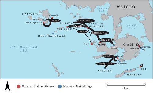
Stories collected from clan elders around Gam and the western islands during our own survey work in 2018 suggest Biak speakers were highly mobile before the 20th century, moving their settlements regularly between islands, and practising ancestor worship and animism (). This is supported by Roxo de Brito, who visited some of Waigeo’s smaller outlying islands in 1582, including ‘Garau’ Island.Footnote125 At the time, in July or August, the island was deserted, probably because those islanders had gone to their gardens to begin the planting season. Following the arrival of Christianity, the Biak groups are said to have first settled permanently at Yefkabu in the Meosmaggara group. During disruptions in the Second World War, people moved from Yefkabu, which is low-lying and very exposed, to Motutru Island near Paniki Island, 10 km to the east, and to Pef, 15 km to the southeast. At the same time these mixed Biak clans visited Pef Island to collect water and plant coconut trees. These groups then moved to Ombrap village on Gam Island and later to the present-day Kabui village on Gam, and to Mutus Island. Biak-speaking people from Arborek Island, following both Islam and Christianity, came to live at Besir on the southeast side of Gam Island for many years but it became too small and so people established another village in the mid-20th century.Footnote126
Figure 7. Historical movements of Biak-speaking groups around the outlying islands southwest of Waigeo, based on oral traditions recorded in 2018.
Around Manyaifun Island, the Biak speakers acknowledge a former population who lived in the area, probably Manyaifun Gebe speakers, Kawe Maˈya speakers, or the Sawai groups from Halmahera. The first Biak settlements known in the area lived at Yenmangkwaen on south Mainyaifun Island, where people settled for a few years as mixed groups,Footnote127 but did not feel safe and so relocated. Manyaifun village itself was established around the start of the Second World War when the existing groups gave permission for Biak speakers to plant crops in the area. Today the village is half Biak Christian and half Islamic from Maluku.
Archaeological Evidence For Settlement Dynamics
Archaeological site distributions around northern Raja Ampat were recorded during a reconnaissance survey in 2018–19.Footnote128 Building upon the linguistic, historical, and ethnographic observations presented above, we now bring the archaeological evidence to bear to provide further insight about past settlement dynamics.
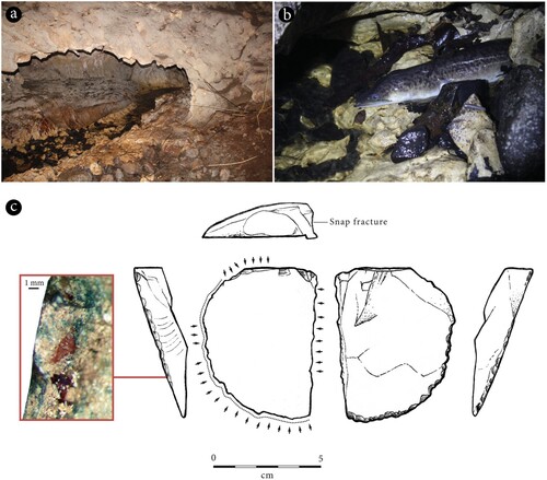
Several archaeological sites have been recorded around the interior of Waigeo and Gam islands (). Many of these are caves and rock-shelters with marine shellfish and sometimes ceramics on the surface. It is likely that these places were used as stopover camps for hunters and foragers, although larger sites may have supported sustained habitation for small family groups. Stories about these sites often refer to them as places of refuge, most recently used by people in the Second World War and during hostilities between the Indonesian and Dutch militaries. Marine shells on the surface of Mungawam (WAI-8) around Mayalibit Bay, Abiap Muden (WAI-36) in south Waigeo, at Frai Kai (WAI-43), Abiap Anday (WAI-46), Anday (WAI-47), Gunung Anday (WAI-66 and WAI-67), Abai Ombon (WAI-57), Abiap Puyauw (WAI-58 and WAI-60), and Manum Bokor (WAI-64) around north Waigeo, Waramkan (WAI-27 and WAI-28) around Waisai Bay, and Nerbaken (WAI-29) in Kabui Bay indicate these sites have been used as this kind of temporary shelter in the recent past.Footnote129 Another cave in north Waigeo, Abiap Puyauw (WAI-59), is a long, weaving limestone tunnel with a freshwater stream flowing through it, containing eels that Ambel ancestors are said to have caught (). A flake tool on the surface of this cave preserves the residue of fish scales and attests to these activities. Flakes like these were made from local cherts and marls, obtained from streambeds or quarries in the forest. Other locations such as Abiap Minki (WAI-10) in Mayalibit Bay are remembered as locations where the elders used to camp, but do not retain surface archaeology. At the Kakit (WAI-4) rockshelter, charcoal drawings written in Papuan Malay suggest these stopover sites have continued to be used throughout the late 20th century to today. In these karst landscapes, crevices, caves, and other geological features are also sacred dwellings for spirits, which can cause sickness or provide favour in hunting, good weather, and fertility.
Figure 8. Map of archaeological locations with site codes mentioned in the text.
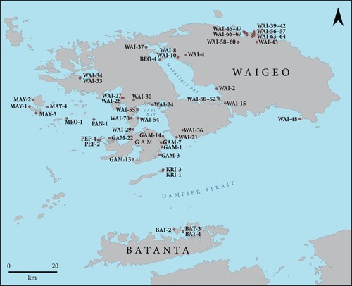
Figure 9. Abiap Puyauw (WAI-59) cave: (a) interior of cave with stream; (b) a freshwater eel currently present in stream; (c) surface find WAI-59-1, a flake with fish scale residue along retouched edge (arrows denote retouch and dotted lines denote macro-use wear).
The Kali Raja site (WAI-30) is perhaps the best example of people’s strong connection to geological features and provides material links to oral traditions that describe the origins of the four Raja Ampat Islands. At this site along the true right bank of the Wawage (Dusun) River, a sacred stone is enshrined in ceramic and metal bowls and shrouded by a mosquito net, housed in a small structure. This is the unhatched egg that was found by Boki Deni, whose story is outlined above. According to interlocutors, a bush hut was first built around the stone in the early 20th century and has been later upgraded to concrete and corrugated iron.
Several burial shelters around the coast and islands of Mayalibit Bay, Kabui Bay, and Aljui Bay provide evidence for nearby habitation within the past five centuries (). Aput Lo (WAI-33), an ossuary formerly used by Selpele Maˈya speakers, is associated with an exposed section of sediment containing charcoal, shell, and bone, likely reflecting food offerings. Radiocarbon dating on charcoal from three discrete layers demonstrates the burial shelter was visited on at least three separate occasions between about 650 and 300 years ago.Footnote130 Pottery from this site, and others, such as nearby shelter WAI-34, include glazed dishes with blue and white painted designs deriving ultimately from China.Footnote131 Other similar sites include Mete Kabum (WAI-2) and Ili Pap (WAI-37) in Mayalibit Bay, Derepas Fwar (WAI-39) on the north coast of Waigeo, Alig Galana (BEO-4) on Beo Island, and Sembama (WAI-70) in Kabui Bay. The earliest Chinese glazed wares in Raja Ampat are tentatively associated with occupation dating maximally to around 1000 years ago at Manwen Bokor (WAI-42) in north Waigeo. Therefore, sites such as WAI-15, at Aris Cape in southern Mayalibit Bay, which contains human bones but is associated with earthenware sherds rather than glazed import ceramics may relate to settlements that predate the mass import of Chinese ceramics in the area. Conversely these sites may have been fossicked to remove those more valuable glazed ceramics or may have been produced by communities that did not have the trade connections necessary to obtain porcelain.
Figure 10. Secondary burial objects from Ambel and Maˈya sites: (a) house burial at Taukapaya (MAY-1); (b) burial furniture collected by Solheim from Kalep Minet (WAI-24), now in the Anthropology Museum, University of Cenderawasih, Jayapura; (c) porcelain plate from Aput Lo (WAI-34) ossuary, decorated with the ‘island of bliss’ motif consisting of a watery landscape with boats on a river, islets, pagodas, shrines, pine trees, mists, and swirling clouds, common in the 16th to 17th century. The presence of a glazed base indicates it was likely made in Jingdezhen, China; (d) porcelain sherds from Aput Lo (WAI-34) shelter including one with a ‘Ming mark’ on the reverse which reads 富貴佳器 (Fugui jiaqi), referring to the ware’s fine quality and ability to bless the owner with wealth. It was a popular inscription on porcelain made for commercial markets and household use in Jingdezhen in the 16th and 17th centuries; (e–g) maker’s marks from Kalep Minet (WAI-24) ossuary including (e) Societe Ceramique mark from Maastricht, in use from 1863–1955, (f) a Petrus Regout & Co. mark from Maastricht in use after 1883, and (g) a George Jones & Co. mark, produced before 1873.
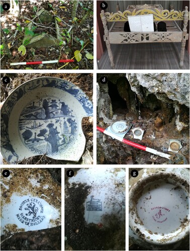
The most extensive secondary burial shelter so far recorded in Raja Ampat is Kalep Minet (WAI-24) on Wayef Island, northern Kabui Bay.Footnote132 It contains numerous glazed bowls, plates, metal teapots, glass bottles, coconut husks, and even wooden furniture and a canoe. Some of the import ceramics appear to be Chinese made, while others derive from European production centres such as Societe Ceramique and Petrus Regout & Co. from Maastricht, the Netherlands, and George Jones & Co. from Stoke-Upon-Trent in Britain. The maker’s marks date the ceramics to the late 19th and early 20th centuries.Footnote133
At Taukapaya (MAY-1) on Manyaifun Island, a small concrete house ossuary is reminiscent of descriptions of similar houses made from bush material on the north coast of Waigeo.Footnote134 The roof of this burial has been broken and its contents removed, perhaps reflecting a phase of fossicking in search of burial goods that could be used as bride wealth. Stories about the site suggest the burial belonged to people who lived in the area prior to the formation of Manyaifun village around the start of the Pacific War, and therefore may belong to Manyaifun Gebe speakers, Kawe Maˈya speakers, or Sawai groups from Halmahera who are reported to have lived in the area prior to Biak movements.
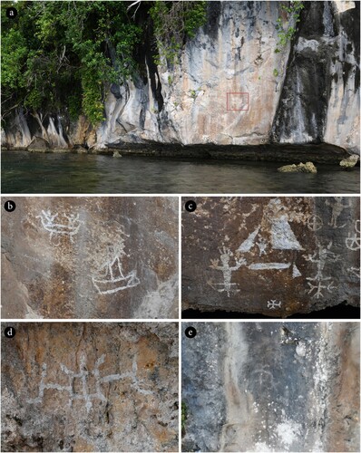
Rock art provides further information about recent activity around the coast (). These sites are painted with white pigment on limestone cliffs around Mayalibit Bay, Kabui Bay, and north Waigeo – the areas where today’s Ambel and Maˈya speakers are based. For instance Yé ha (WAI-50), Yé Lal (WAI-51), and Yé Mampier (WAI-52) at the entrance to Mayalibit Bay depict anthropomorphs, zoomorphs, and hybrid humanoids with animal heads along with abstract geometrics. Yé Lal also depicts two people in a canoe meeting with a sail boat, perhaps a Malay perahu, Chinese junk, or Dutch schooner.Footnote135 In Kabui Bay, Mlelen Popo (WAI-54) and Fafag (WAI-55) depict similar if not identical anthropomorphs, zoomorphs, canoes, sailing ships, and abstract designs. The scene at Fafag is the most cohesive and depicts anthropomorphs with arrows through their torsos. Stories about this site indicate these paintings represent newcomers – possibly Biakers, people from Maluku, or beyond – being attacked by local Maˈya. Finally, a small piece of white rock art (WAI-63), recorded by previous archaeologists,Footnote136 displays an identical geometric pattern to those around Mayalibit Bay and Kabui Bay and suggests a common design system around these parts of Waigeo.
Figure 11. White rock art around Waigeo Island: (a) Yé lal (WAI-51) showing art highlighted in red above the tidal notch, about 2 m above mean sea level; (b) detail view of WAI-51 Panel 1, showing two people in canoe with characteristically uplifted arms welcoming sail boat; (c) detail of Fafag (WAI-55) rock art – according to stories, this shows conflict between local groups and newcomers, with the figure on the left having been shot with an arrow; (d) detail of Mlelen Popo (WAI-54) rock art, possibly a crustacean; (e) faded geometric painting at WAI-63, originally recorded by Solheim and others.
In north Waigeo, Abai Ombon (WAI-56) is a defensively positioned former settlement up a steep limestone cliff. It runs east-to-west, looking down onto the Rainkan River and the northern coastline. A surface survey recorded marine shells as well as earthenware pottery sherds from sago ovens, quartz tools, and glazed ceramics. The ceramics appear to be Chinese with no evidence for European ceramics at the site, tentatively suggesting the site was occupied before the late 19th century. Stories about the site indicate it was inhabited by an inland people (probably Ambel speakers) before Biakers moved to the area, after which they fled to small islands north of Waigeo.
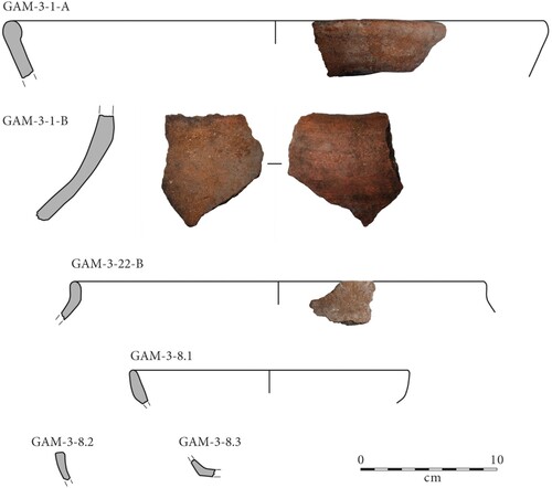
Some sites from the Biak language area reflect relocations that have occurred following the initial movement of Biak speakers to the region. For instance, test excavations involving four 0.5 × 0.5 m test pits at Nydandebas (GAM-3) on Kerubepyar Island near Gam revealed a thin sedimentary profile overlying coral limestone (). Charcoal from the four test pits remains undated, but stories about the site suggest it was most recently occupied sometime in the 20th century in association with Maˈya speakers who moved from the Wawiyai area to settle around Gam. Ceramics recovered from the surface of the site are both red-slipped earthenware and imported glazed wares (), and it is unclear if these relate to the recent Maˈya settlement, or an earlier (perhaps Biak speaking) occupation. Thin-bodied earthenware with calcareous temper, present down to about 30 cm below the surface in Area 2, may predate these wares. However, in our assessment they are unlikely to be substantially older than the surface finds. If this diverse variety of earthenware forms is local to the northern Raja Ampat Islands, it suggests that these potting traditions only recently ceased, within the past few hundred years (perhaps as late as the 20th century). Alternatively, some ceramics, such as sherd GAM-3-1-A, may derive from major production centres such as Mare Island near Tidore. Today, only rectilinear sago ovens continue to be made by Biak speakers near the north coast of Batanta and by Ambel speakers in Waigeo’s Mayalibit Bay.Footnote137
Figure 12. Drone photography of Nyandebas showing location of test pits.
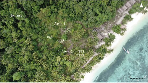
Figure 13. Stratigraphy of Nyandebas TP3 and TP4, looking west.
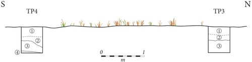
Figure 14. Earthenware rim and neck sherds recovered from Nyandebas (GAM-3). GAM-3-1-A, large rim from surface of site with internal red slip; GAM-3-1-B, neck from surface of site with internal red-slip, which presumably derives from same vessel as GAM-3-1-A; GAM-3-22-B, thin rim, unslipped, from TP4 Layer 1, Spit 3, made from a different fabric to GAM-3-1-A and GAM-3-1-B; from TP2 Layer 1, Spit 1, are GAM-3-8.1 and GAM-3-8.2, thin rims, and GAM-3-8.3, a thin corner point of dish, all unslipped and made from a similar fabric to GAM-3-22-B.
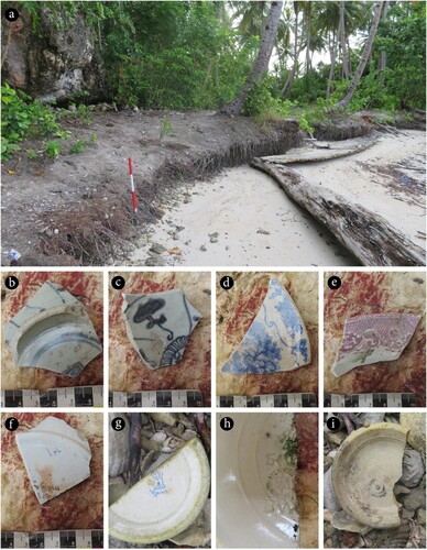
The majority of recent sites in the Raja Ampat archaeological record are restricted to the coast and to very small offshore islands, located on low-lying Holocene sand and coral formations (many islands being less than 1 km in their maximum extent). The most extensive site yet recorded is the Kampung Tua (GAM-13) near Kapisawar village, southern Gam Island. Based on its location, in comparison with charts from 1930–1, this is one of two former Biak speaking settlements known as Besir. The absence of a Besir on the chart of 1918–19 suggests the settlement was founded sometime in the 1920s, in line with oral testimonies. The archaeological site itself is a long strip of thin coastal midden, stretching almost 100 m along the beach flats, in a small cove at the entrance to Gaman Bay. Alongside shell midden, ceramics at the site include glazed import wares and brown glazed earthenware deriving from Europe, China, and Thailand (). Two of these sherds were produced by FAM Bonn in Germany, displaying maker’s marks in use from the late-19th century until 1920. A burial marked by coral and a large, glazed plate is similar to a coral lined burial from Kodor (MAY-2) on Meos Kodor near Manyaifun and may mark a style of burial that post-dates ossuaries but predates concrete-lined graves.
Figure 15. Kampung Tua (GAM-13), the former ‘Besir’ settlement: (a) site with midden eroding from the beach flats; (b–c) Chinese porcelain; (d–e) European glazed earthenware; (f) Thai characters on earthenware plate; (g) ‘tower mark’ from FAM Bonn, produced between 1885 and 1920; (h) impressed mark from FAM Bonn, used around 1870 to 1920; (i) crescent and star maker’s mark with ‘Made in Germany’.
The location of the northerly Besir village marked on the 1930–1 chart has not yet been determined. At GAM-7, about 1.5 km inland from Raswan village, earthenware and import glazed ceramics were recorded marking a former garden or habitation. A bottle derives from Amsterdam, suggestive of a late 19th to mid-20th century occupation, while transfer-printed glazed earthenware and painted porcelain indicate imports from Europe and possibly China. This may reflect a garden or house site contemporary with the northern Besir settlement.
At Ombrap (GAM-22), the site of a current pearl farm on north Gam Island, a cemetery with three concrete graves dates to the mid-20th century (one labelled 1956) and import ceramics indicate the site of a former settlement. This settlement may have been of a similar extent to Besir, given the length of the beach flats, but it does not appear to have hosted a sustained period of occupation. According to Biak oral histories, this location is where people lived after moving from Paniki and Mututru but before moving to Kabui village.
At Mututru Island (PAN-1), near the larger Paniki Island, surface pottery is present along with a cemetery dating to the mid-20th century (one grave labelled 1956) and a monument to the first church reportedly built in 1945. Similarly, on Pef Island, Yenmaret (PEF-2) and Yenikwaen (PEF-4) include shell midden and small scatters of pottery and metal. One sherd from Yenmaret displays a ‘Samarcan’ transfer print and a Petrus Regout maker’s mark that was produced between 1880–90. On Yefkabu Island (MEO-1), the beach flats preserve shell midden and glazed import ceramics. A memorial about 30 metres inland notes the place of a former village, which, according to oral traditions, was the first place the Biak settled down and received the Bible in 1941. From archaeological evidence it remains unclear when the island was first settled or how long the island was inhabited before people left to settle other areas including Mututru and Pef.
At Yenmangkwaen (MAY-3) on the southeast side of Manyaifun Island, a water well is the only remnant of a former settlement said to have existed for three years, immediately prior to the founding of Manyaifun village. Conversely, at Yentamako (MAY-4) on a small island nearby, import ceramics and shell midden indicate the presence of a settlement that was used before people moved to Manyaifun. One sherd with an Art Nouveau fruit spray décor design and mercury ink stamp derives from the Villeroy and Boch factory in Wallerfangen, Germany, which was producing ceramics at the turn of the 20th century. Another sherd with a ‘Colibri’ design bears a mark from Petrus Regout of Maastricht and dates to the late 19th or early 20th century.
Although no mention is made of settlements on Kri or Mansuar Islands in European charts, surface sherds of Chinese and Dutch origin reflect wide trade connections, with habitation occurring along the coast at sites such as KRI-3, today a diving resort, and in the hills, at locations like KRI-1, today a helicopter hangar. Similarly, at Memyai Island (WAI-48) around eastern Waigeo, the beach flats preserve shell midden and glazed European ceramics that indicate occupation in the late 19th or early 20th century. Based on this insular and coastal settlement pattern, these places may represent Biak speaking settlements used before people moved to the mainland of Waigeo and Gam, but we have not yet recorded oral history or archaeological evidence to determine the language affiliations of these sites.
In the Batanta area, several coastal sites provide hints at previous occupation either by Biak speakers or Olon/Batta speakers. At Kris Iba (BAT-1) on the northwest coast of Birie Island, sherds included those from globular pots as well as a sago oven with a carved design reminiscent of Makbon pottery on the Bird’s Head.Footnote138 Present-day potters at nearby Arefi and Yensawai villages make sago ovens, but not with decorations of this sort. At BAT-4 on the nearby Yu Island, glazed import ceramics, bottle glass, and shell midden denote a period of later settlement associated with a clay source (BAT-3) used by the grandmothers of today’s potters. If this is the case, it indicates that the site was in use about a century ago, which corresponds to ceramic types recorded at the site, including glazed earthenware cups, dishes, and plates.
As in Maˈya and Ambel areas, ossuaries are present around today’s Biak settlements. In these places, dog remains are sometimes also encountered. For instance, Yenbainus (GAM-1) is a crevice containing human remains claimed to be Japanese soldiers and associated with a dog cranium and late-20th century pottery. Tapor Inkasowi (GAM-14) is a small cave that contains bamboo used to wash sick people, and is associated with import pottery and a dog mandible. Lestar cave (WAI-21) near to Sapokren village also contains a dog crania and post cranial bones. It is not clear from the archaeological remains whether all ossuaries in present-day Biak-speaking areas relate to Biak settlements or earlier occupation.
At Sawai Bokor (WAI-40), a rock-shelter on the north coast of Waigeo, 12 human skulls are arranged neatly in a three-by-four arrangement, along with a pile of post-cranial bones and glazed ceramic fragments. These ceramics are Chinese in origin, and stories about the site suggest the remains relate to Sawai people from Patani in southeast Halmahera. In 1956, two Dutch officials visited this same ossuary, which they described as a ‘Biak cemetery’.Footnote139 Stories about the site stressed that the bones related to Sawai people who were lured there by Biak men, Pasrif and Fakok. At the time of the officials’ visit, the site also contained two 1.25 m long crates made from iron and wood in the shape of a large fish. A third crate was said to have originally been present but had since decayed. These were filled with 14 skulls and some post-cranial bones in secondary burial contexts. A square ceramic sago oven, divided into four compartments, was also found nearby along with two korwar ancestor figures.Footnote140 Similar burial crates, no longer present at Sawai Bokor, have since been recorded at two nearby sites: on a boulder at Manwen Bokor (WAI-42) alongside polished axes and pottery, and in a crevice at Abai Omon (WAI-41). These coffins are characteristic of those made in the Biak homeland of Cenderawasih Bay in the late 19th century.Footnote141
Discussion
It is clear that early European accounts, usually collected by navigators who visited the Raja Ampat Islands for periods of a few weeks or months, provide a relatively static vision of human settlement that masks the diachronic complexity of the area. The past five centuries, at least, have been characterized by differential rates of settlement relocations and human mobility that took place alongside a changing economic and social landscape, political disputes, religious conversions leading to community fission and fusion, resource exhaustion, and a host of other processes. These movements shaped the distribution of languages, religious beliefs, and subsistence systems around the archipelago in more complex ways than has usually been described.
The combined linguistic, ethnographic, historical, and archaeological evidence prompts us to rethink the relationship between today’s settlements, their language affiliations, and the narratives about their recent histories. This is especially the case because the evidence makes clear that there have been numerous clan and family-scale movements that have led to high levels of intermarriage. For instance, the term Maˈya is complicated because it masks several dialects and languages spoken in places with historically distinct settlement dynamics and patterns of movement. Remijsen suggests that the southern Maˈya people around Misool and Salawati were coastally orientated, Muslim, and connected with Seram at the end of the 18th century. Conversely, the Kawe and Wawiyai Maˈya people around Waigeo were animists with an interior inclination but oral traditions that strongly tied them to Halmahera and its satellites.Footnote142 Similarly, Ambel speaking people will often describe themselves as Maˈya, which has become a term to denote indigeneity throughout Raja Ampat, but Ambel speakers also moved readily around the interior of Waigeo until a few hundred years ago.
Similarly, the differences between Raja Ampat Biak dialects may reflect different types of interaction with people already living in the islands. For instance, many current Beser Biak speakers have ancestry that includes both Biak and Maˈya/Ambel speakers, and if one asks a Raja Ampat Islander whether their ancestors came from Cenderawasih Bay, the coast of Waigeo, or the interior, the answer might be yes to all three. As van der Leeden noted, it was ‘truly amazing how quick, even after one generation, the descendants of “newcomers”, not always through marriage but also otherwise, integrated … They quickly forgot their original culture and language and became Raja Ampat islanders’.Footnote143 It would be a mistake, then, to think there was a time in recent history that did not involve these kind of complexities and therefore that present day settlements represent distinguishable cultural units that can be seamlessly traced back through time.
Certainly – as white rock art depicting hostilities vividly makes clear – not all of these movements were amiable. Secondary dispersers,Footnote144 such as some Maˈya speakers who moved to southern Misool, and Biak speakers who moved to the north coast of Batanta and west coast of Waigeo, established stand-offish settlements on offshore islands. Moreover, settlements on the coast of Waigeo were often cautiously located within coves, up a maze of rivers,Footnote145 and on top of hilltops and cliffs. In most of these areas, caves and rock-shelters known to hunters and foragers could be used as refuges during conflict.
Whether these conflicts were restricted to the period of hongi raiding from Maluku is unclear, but probably unlikely. The authority over the Raja Ampat Islands that European powers assigned to Tidore may have had little impact on day-to-day life in Raja Ampat until the 19th century. Swadling notes that Tidore’s authority was largely symbolic, with the small island used as a vassal to justify claims to the Raja Ampat Islands by the Dutch and British, particularly at the end of the 18th and start of the 19th centuries.Footnote146 After the Dutch legitimized Tidore’s claim to western New Guinea in 1848, tribute demands and hongi raids became more frequent until the latter were outlawed in 1861.Footnote147 It is likely that people’s fear of retribution and raiding from Tidore partly shaped defensive settlement locations.
Conversely, other examples of relocation were hospitable, drawing on a common understanding of sasi rights. Such movements included when Maˈya and later Biga speakers moved to Misool and negotiated land rights with Matbat groups, and when Biak speakers moved to Manyaifun where extant Maˈya speakers allowed them to plant crops. Such relocations also allowed access to exchange connections. As Corbey mentions, Maˈya and Biak speakers in particular were able to monopolize trading contacts between Maluku and New Guinea.Footnote148 It remains unclear if Biak speakers from Cenderawasih Bay already had exchange connections with Tidore and later settled unoccupied islands in Raja Ampat, or if these connections emerged from the Raja Ampat Biak speakers being in closer proximity to Maluku. The openness of these Biak speaking settlements was noted by early Europeans moving along the north coast of Waigeo during the 18th century.
In the 19th century, Waigeo was not frequently visited by traders, with Malukan, Chinese, and European trips visiting Samati on Salawati, which was an exchange hub for bird plumes, turtle shells, pearls, sea cucumber, and slaves.Footnote149 The presence of Chinese ceramics around Waigeo, however, supports evidence from other locations, such as the Risatot site on Arguni Island,Footnote150 that traders from a wider sphere of interaction were regularly converging on hubs such as Samati to redistribute exotic material throughout the islands. It is likely that a number of technologies prominent in Maluku entered the Raja Ampat area through these new networks; these include iron reworking,Footnote151 and perhaps sago oven manufacture.Footnote152
Conclusion
Having established that complex settlement dynamics were characteristic of the archipelago’s recent past, we conclude by providing a narrative sequence and, where possible, tentative chronology for some of the key settlement processes operating in the northern Raja Ampat islands within the past five centuries. By the time of the first European forays through the islands 500 years ago, the descendants of intermarriages between speakers of RASH and local non-Austronesian languages included mobile foragers and agroforesters who lived in the interior of the large Raja Ampat Islands. It is unclear whether these same groups frequented coastal sites too, or if there was a distinction between inland and coastal groups at this time. Before and after this time, movements to establish settlements on other islands led to the genesis of new languages, in the instance of multiple movements from Waigeo to Misool, developing into Matbat, Maˈya, and Biga speaking groups. It may be that the sasi system of landscape management was practised at the time of these relocations, and this system would have had important implications for the nature of these secondary dispersals, including marriage between groups, access to subsistence foods, and trade opportunities. A lack of such rights amongst secondary dispersers could have regularly encouraged Raja Ampat groups to establish trade (or raiding) contacts throughout the islands and as far as Maluku, Cenderawasih Bay, and the Bird’s Head of New Guinea.
By the time that Tidore’s influence in the area was at its peak in the mid-19th century, owing to raiding, trading, and extraction of tribute, many inland groups had shifted from being highly mobile to living in more fixed settlements a few kilometres from coast. By the late 19th and early 20th centuries, most inland groups had relocated to coastal settlements. Stories passed down within these settlements about inland peoples probably recall ancestors, some of whom lived inland, while others lived on the coast.
The movement of Biak speakers to Raja Ampat may be symbolized by the story of Gurabesi, who established connections with Tidore and intermarried with Maˈya groups around southern Waigeo. Currently, the precise timing of these movements is unclear and we earlier outlined two hypotheses for the dispersal of Biak speakers into Raja Ampat: an early movement that began at the start of the 16th century, or a late movement in the early-to-mid 18th century. Whether one or the other of these hypotheses is demonstrated to be accurate, there was not one major pulse of movement of Biak speakers from Cenderawaish Bay, but numerous movements of Biak families and clans into and around the islands. These movements continued into the 20th century, when settlements became more fixed and mobility was less frequent, especially around the small western satellites of Waigeo. The Biak speakers’ settlement pattern during this time was characteristic of secondary maritime dispersers, focused on small islands away from the mainland. This pattern may have been voluntary to some degree, but it was also shaped by established groups of Maˈya and Ambel speakers dictating which pieces of land could be settled upon, and which could not.
Within the same time period, especially around the west coast of Waigeo, people from Halmahera such as the Sawai speakers moved around the offshore islands, eventually intermarrying with people on Batanta and the western islands of Waigeo. The process of forming new settlements with mixed groups seems to have been common, and is still operating at villages such as Warsambin and Asokweri, where half the village speaks Ambel and half the village speaks Biak.
In summary, this article has explored the temporal dynamics of settlement and mobility around the northern Raja Ampat Islands of West Papua. Despite the area being home to low-density human populations, the available historical, ethnographical, linguistic, and archaeological evidence demonstrates that the past five centuries have witnessed at-times rapid, and invariably complex, rearrangements of settlement location and toponymy, as clans speaking several distinct Austronesian languages and dialects interspersed themselves throughout the Raja Ampat archipelago. The complexities of these movements, often operating at the clan, family, and individual level, force us to rethink the direct relationship between present-day village locations, language affiliations, and meta-narratives about population migration.
Acknowledgements
We thank the communities of Waigeo, Batanta, and Gam for their assistance and hospitality during fieldwork. We are grateful to Siyi Wu at the University of Oxford and Zhang Aixing at Fudan University for their advice on Chinese porcelain, and Christoph Parsch and Erlani Rahareng for assistance with taxonomic identification. We also thank two anonymous reviewers for their constructive comments, and the Journal of Pacific History for editorial oversight.
Disclosure Statement
No potential conflict of interest was reported by the author(s).
Additional information
Funding
Notes on contributors
Dylan Gaffney
Dylan Gaffney – School of Archaeology, University of Oxford, Oxford, UK; Archaeology Programme, School of Social Sciences, University of Otago, Dunedin, NZ. [email protected]
Daud Tanudirjo
Daud Tanudirjo – Department of Archaeology, Gadjah Mada University, Yogyakarta, Indonesia. [email protected]
Laura Arnold
Laura Arnold – Department of Linguistics and English Language, University of Edinburgh. [email protected]
Wolter Gaman
Wolter Gaman – Forum Intelektual Suka Maˈya Waisai, Indonesia. [email protected]
Tristan Russell
Tristan Russell – Archaeology Programme, School of Social Sciences, University of Otago. [email protected]
Erlin Djami
Erlin Djami –Pusat Riset Arkeologi Prasejarah dan Sejarah, Badan Riset dan Inovasi Nasional, Jayapura, Indonesia. [email protected]
Abdul Macap
Abdul Macap – Balai Pelestrian Kebudayaan Wilayah XXIII, Manokwari, Indonesia. [email protected]
Notes
1 Dylan Gaffney, ‘Human Behavioural Dynamics in Island Rainforests: Evidence from the Raja Ampat Islands, West Papua’ (PhD thesis, University of Cambridge, 2021).
2 Sheila McKenna, G.R. Allen, and S. Suryadi, A Marine Rapid Assessment of the Raja Ampat Islands, Papua Province, Indonesia (Washington, DC: Conservation International, 2002).
3 For descriptions of the former see Louis de Freycinet, Voyage autour du Monde, pendant les Anneés 1817, 1818, 1819 et 1820. Historique. Livre III. Des Timor aux Mariannes Inclusivement (Paris: Chez Pillet Aîné, 1829) and Alfred Russel Wallace, The Malay Archipelago (London: Macmillan and Co, 1869). Freycinet (p. 20) describes favourable contact with people on the north coast of Waigeo, where local leaders – Srouane from Boni Island and Moro from the Ayu Islands – became regular dinner guests. Wallace (p. 497) describes people from Waigeo and Batanta paddling out to meet him in the Dampier Strait to sell their wares. For descriptions of the latter see Leonard Y. Andaya, The World of Maluku (Honolulu: University of Hawai‘i Press, 1993); Thomas Forrest, A Voyage to New Guinea and the Moluccas, 1774–1776 (Oxford: Oxford University Press, 1780 [1969]); and F.H.H. Guillemard, The Cruise of the Marchesa to Kamschatka & New Guinea, vol. II (London: John Murray, 1886). Andaya (p. 103) records that the Dutch expedition of 1705–6 described the islanders as ‘simple and artless, but cruel, rapacious, and murderous’. Forrest (p. 80) notes that descriptions of Raja Ampat reclusivity and hostility may have been driven by the fears of his Malay interlocutors. Guillemard (p. 250) notes that his crew refused to go ashore on Sagewin Island near Batanta ‘alleging that the natives were not to be trusted’.
4 F. Huizinga, ‘Relations between Tidore and the North Coast of New Guinea in the Nineteenth Century’, in Perspectives on the Bird’s Head of Irian Jaya, Indonesia, ed. J. Miedema, C. Odé, and R.A.C. Dam (Amsterdam: Rodopi, 1998), 385–419; Muridan Widjojo, The Revolt of Prince Nuku: Cross-cultural Alliance-making in Maluku, c. 1780–1810 (Leiden: Brill, 2009), 96. Tidorese traditions suggest, from the late 15th to the late 18th century, the sultan managed the extraction of materials from Raja Ampat by subordinating rajas on Gebe Island. Prior to this, the Sultanate of Bacan had trade connections with Raja Ampat, and maintained these connections with Misool. Widjojo suggests the subordination of Raja Ampat may have occurred later, in the mid-17th century.
5 A. Haga, Nederlandsch Nieuw Guinea: Historische Bijdrage ±1500–1883 (Batavia: W. Bruining & Co, 1884).
6 Heinrich Bernstein, ‘Mededeelingen nopens reizen in den Indischen Archipel’, Tijdschrift Indische Taal-, Land- en Volkenkunde 17 (1864): 79–109; Wallace, The Malay Archipelago; Hermann von Rosenberg, Der Malayische Archipel (Leipzig: Verlag von Gustav Weigel, 1878); Evelyn Cheesman, Six Legged Snakes in New Guinea (London: Harrap, 1949).
7 Dylan Gaffney and Marlin Tolla, ‘A Historiography of Research on West New Guinea’s Human Past’, in West New Guinea: Social, Biological, and Material Histories, ed. Dylan Gaffney and Marlin Tolla (Canberra: ANU Press, forthcoming).
8 Formerly at Noe village on Yefnu Island until sometime between 1944–79, see .
9 Albert C.L. Remijsen, Word-Prosodic Systems of Raja Ampat Languages (Utrecht: LOT, 2001), 14.
10 Robert Blust, ‘Eastern Malayo-Polynesian: A Subgrouping Argument’, in Second International Conference on Austronesian Linguistics: Proceedings, ed. Stefan Wurm and Lois Carrington (Canberra: Australian National University, 1978), 181–234; Robert Blust, ‘More on the Position of the Languages of Eastern Indonesia’, Oceanic Linguistics 22–3 (1983–4): 1–28; David Kamholz, ‘Austronesians in Papua: Diversification and change in South Halmahera-West New Guinea’ (PhD thesis, University of California Berkeley, 2014); Remijsen, Word-Prosodic Systems.
11 Blust, ‘Eastern Malayo-Polynesian’; Blust, ‘More on the Position of the Languages of Eastern Indonesia’; Kamholz, Austronesians in Papua, 142–4; Matthew Spriggs, ‘“I was so much older then, I’m younger than that now”: Why the Dates Keep Changing for the Spread of Austronesian Languages’, in A Journey through Austronesian and Papuan Linguistic and Cultural Space: Papers in Honour of Andrew K. Pawley, ed. John Bowden, Nikolaus P. Himmelmann, and Malcolm Ross (Canberra: Australian National University, 2010), 113–40.
12 Kamholz, Austronesians in Papua, 142–3.
13 We do not have up-to-date information about whether the Gebe language continues to be spoken on Gag.
14 Kamholz, Austronesians in Papua, 143.
15 Laura Arnold, ‘The Diachrony of Word Prosody in the Maˈya-Salawati Languages of Raja Ampat’, Oceanic Linguistics (forthcoming).
16 Laura Arnold, ‘Four Undocumented Languages of Raja Ampat’, Language Documentation and Description 17 (2020): 25–43; Keith Berry and Christine Berry, ‘A Survey of some West Papuan Phylum Languages’, Workpapers in Indonesian Languages and Cultures 4 (1987): 25–80.
17 Remijsen, Word-Prosodic Systems, 24.
18 A. Van der Leeden, Maˈya: A Language Study (Leiden: Leiden University, 1993); Wallace, Malay Archipelago, 355.
19 Arnold, ‘The Diachrony of Word Prosody’.
20 Arnold, ‘Four Undocumented Languages’.
21 Laura Arnold, ‘Highs and Lows: A Previously Unattested Tone Split from Vowel Height in Metnyo Ambel’, Transactions of the Philological Society 118 (2020): 141–58.
22 Arnold, ‘Four Undocumented Languages’; Van der Leeden, Maˈya; Clemens L. Voorhoeve, Languages of Irian Jaya Checklist: Preliminary Classification, Language Maps, Wordlists (Canberra: Pacific Linguistics, 1975); Lourens de Vries, ‘Some Remarks on the Linguistic Position of the Inanwatan Language’, Perspectives on the Bird’s Head of Irian Jaya, Indonesia. Proceedings of the Conference, Leiden, 13–17 October 1997, ed. Jelle Miedema, Cecilia Odé, and Rien A. C. Dam (Amsterdam: Rodopi, 1998), 643–53.
23 That is, the origin and emergence of tone in a language.
24 Arnold, ‘Highs and Lows’; Laura Arnold, ‘A Preliminary Archaeology of Tone in Raja Ampat’, NUSA 64 (2018): 7–37.
25 That is, new features relating to the morphology (forms of words and phrases) and the syntax (structure and arrangement of words in a sentence) of language.
26 That is, conceptual distinctions between living and non-living things.
27 Laura Arnold and Emily Gasser, ‘Austronesian-Papuan Contact in Northwest New Guinea’, in The Oxford Guide to the Papuan Languages, ed. Nick Evans and Sebastian Fedden (Oxford: Oxford University Press, forthcoming).
28 Remijsen, Word-prosodic Systems, 26.
29 Badan Pusat Statistik Kabupaten Raja Ampat, Kabupaten Raja Ampat Dalam Angka 2020 (Waisai: BPS Raja Ampat, 2020).
30 Jelle Miedema and Willem A.L. Stokhof, Memories van Overgave van de Afdeling Zuid Nieuw-Guinea (Part II) (Leiden: DSALCUL/IRIS, 1993), 274; Van der Leeden, Maˈya, 2; Badan Pusat Statistik Kabupaten Sorong, Sorong Dalam Angka (Sorong: BPS Sorong, 1998); Biro Pusat Statistik, Statistik Indonesia (Jakarta: Biro Pusat Statistik, 2011); Badan Pusat Statistik Kabupaten Raja Ampat, Kabupaten Raja Ampat Dalam Angka 2020.
31 Roxo de Brito’s account is compiled and translated in a Spanish codex of c. 1590, known as the Boxer Codex. See Charles R. Boxer ‘A late 16th Century Manila MS’, in Portuguese Conquest and Commerce in Southern Asia, 1500–1750 (Farnham: Varionum, 1950); Charles R. Boxer and Pierre-Yves Manguin, ‘Miguel Roxo de Brito’s Narrative of his Voyage to the Raja Empat (May 1581–1582)’, Archipel 18 (1979): 175–94. For a recent translation, see M. Roxo De Brito, ‘New Guinea’, in The Boxer Codex: Transcription and Translation of an Illustrated Late Sixteenth-Century Spanish Manuscript Concerning the Geography, Ethnography and History of The Pacific, South-East Asia and East Asia, ed. G.B. Souza and J.S. Turley (Leiden: Brill, 2016), 503–24.
32 Roxo de Brito met with the Raja of Baygeo (Waigeo), but it is unclear where this raja was based – the location given in the Boxer Codex reads ‘Boron’ which could relate to a batan (large island). See J.H.F. Sollewijn Gelpke, ‘The Report of Miguel Roxo de Brito of his Voyage in 1581–1582 to the Raja Ampat, the MacCluer Gulf and Seram’, Bijdragen tot de Taal-, Land- en Volkenkunde van Nederlandsch-Indië 150 (1994): 123–45. Sollewijn Gelpke suggests this is modern Gam (previously Gaman) Island, which matches Roxo de Brito’s description of Boron measuring about 15 leagues in circumference and supporting a population of about 1000 men. Compare with Forrest, A Voyage to New Guinea, 86. Thomas Forrest, writing two centuries later, noted that the Raja of Waigeo lived on the largest island in Mayalibit Bay, by which he means Beo Island (too small to be de Brito’s ‘Boron’).
33 Roxo de Brito, ‘New Guinea’, 505. The Spanish ‘hombres’ is used, and presumably Roxo de Brito was estimating the number of adult men in the settlement, informed by figures provided by the rajas, rather than the total population.
34 Sollewijn Gelpke, ‘The Report of Miguel Roxo de Brito’, 127.
35 Von Rosenberg, Der Malayische Archipel, 374, 393.
36 Von Rosenberg, Der Malayische Archipel, 377, 388. Although the north coast was not inhabited, the south of Batanta was said to have three small settlements in 1883; Guillemard, The Cruise of the Marchesa, 250–6. It seems likely that these settlements were used by Olon/Batta speakers.
37 Cheesman, Six Legged Snakes, 126.
38 Kamma, Koreri, 8.
39 Andaya, World of Maluku, 102.
40 Around the north coast of Waigeo, Von Rosenberg, Der Malayische Archipel, 381, describes these groups living at Brej (now Kabare), and Usba on Boni Island; see also F.S.A. de Clercq, De West- En Noordkust van Nederlandsch Nieuw-Guinea (Leiden: E.J. Brill, 1893). For reference to Oesba, see F.S.A. de Clercq, Ethnographische Beschrijving van de West- En Noordkust van Nederlandsch Nieuw-Guinea (Leiden: P.W.M. Trap, 1893). Around the south coast these groups lived at Bessir (probably the northernmost Besir, located inland from today’s Yenbeser village, northeast Gam Island) and Umka (Omko/Amka noted on charts between 1756–1903 and shown in and , close to modern-day Sapokren village). On the east coast, these groups lived at Makerej (possibly the former settlement of Wakre, as recorded on a chart of 1944, see ). In Mayalibit Bay, these groups lived at Samsam (probably Lamlam, close to modern Kapidiri village, or perhaps another name for Fafak in Mayalibit Bay, whose inhabitants later shifted to Lamlam), Nok (the former name for Warimak settlement, see Cheesman, Six Legged Snakes), and Kawalej (possibly Kabilol). Samsam may alternatively refer to Metsam, a dialect of Ambel today spoken at Warsambin and Kalitoko. See Laura Arnold, ‘Grammar of Ambel: An Austronesian Language of Raja Ampat, West New Guinea’ (PhD thesis, University of Edinburgh, 2017), 24.
41 Arnold, Grammar of Ambel, 8.
42 Von Rosenberg, Der Malayische Archipel, 381. These settlements included Fiaei, Kassandon, Wakaf, and Waita, and two of these settlements lend their names to present-day Ambel clans: Fiay and Wakaf. Guillemard, The Cruise of the Marchesa, 262, describes a small ‘village of four huts’ two miles inland along a river on the west coast of Mayalibit Bay and notes that the occupants were not like ‘Waigiou Papuans of unmixed blood’ but were ‘Alfuros’, a Tidorese term later used by the Portuguese and Dutch to refer to Indigenous peoples.
43 De Clercq, De West- En Noordkust van Nederlandsch Nieuw-Guinea.
44 Cheesman, Six Legged Snakes.
45 Remijsen, Word-Prosodic Systems, 24, 27.
46 Ibid., 176.
47 Huizinga, ‘Relations between Tidore and the north coast of New Guinea’.
48 Remijsen, Word-Prosodic Systems, 171.
49 Cheesman, Six Legged Snakes, 117.
50 Wallace, The Malay Archipelago, 405.
51 Cheesman, Six Legged Snakes, 85.
52 Ingvild Harkes and Irene Novaczek, ‘Presence, Performance, and Institutional Resilience of Sasi, a Traditional Management Institution in Central Maluku, Indonesia’, Ocean & Coastal Management 45 (2002): 237–60; Irene Novaczek et al., An Institutional Analysis of Sasi Laut in Maluku, Indonesia (Penang: ICLARM-The World Fish Center, 2001); Sandra Pannell, ‘Managing the Discourse of Resource Management: The Case of Sasi from “Southeast” Maluku, Indonesia’, Oceania 67 (2007): 289–307; Ian N. Parker, ‘Recognition and Strangeness in Marine Environmental Encounters on New Guinea’s Far Western Coast’ (PhD thesis, UC San Diego, 2013); Craig C. Thorburn, ‘Changing Customary Marine Resource Management Practice and Institutions: The Case of Sasi Lola in the Kei Islands, Indonesia’, World Development 28 (2000): 1461–79.
53(a) De Freycinet, Voyage autour du Monde; (b) Guillemard, The Cruise of the Marchesa, 266; (c) Guillemard, The Cruise of the Marchesa, 269; (d) Anon, Photograph of huts in a village probably at Offak Bay, 1917, Australian War Memorial Archives, Canberra, Australia, P05338.130; (e) Anon, Paalwoningen vermoedelijk aan de kust van Waigeo, c.1920, Leiden UniversityLibraries, KITLV Archives, Leiden, the Netherlands, 150981; (f) Photograph by Tristan Russell, Raja Ampat Archaeological Project, 2018.
54 Elizabeth McLeod, Brian Szuster, and Rodney Salm, ‘Sasi and Marine Conservation in Raja Ampat, Indonesia’, Coastal Management 37 (2009): 656–76.
55 Ryan Donnelly, Duncan Neville, and Peter J. Mous, Report on a Rapid Ecological Assessment of the Raja Ampat Islands, Papua, Eastern Indonesia Held October 30–November 22, 2002 (Sanur: The Nature Conservancy, 2003), 36.
56 Peter V. Lape, ‘Historic Maps and Archaeology as a Means of Understanding Late Precolonial Settlement in the Banda Islands, Indonesia’, Asian Perspectives 41 (2002): 43–70.
57 Coutts Trotter, ‘New Guinea: a Summary of our Present Knowledge with regard to the Island’, Proceedings of the Royal Geographical Society and Monthly Record of Geography 6 (1884): 196.
58 J. Sollewijn Gelpke, ‘On the Origin of the Name Papua’, Bijdragen tot de Taal-, Land- en Volkenkunde van Nederlandsch-Indië 149 (1993): 318–32.
59 Ibid.
60 The word ‘Papoos’ is used on Dutch charts.
61 Waigeo is often ‘Angeuw’ Island on early charts. E.g., Carte de la partie occidentale de la Nouvelle Guinee et des detroits adjacents d’apres un manuscrit Hollandois qu’on suppose avoir ete fait dans le voyage de Geelvink en 1705, Papers of Matthew Flinders, National Library of Australia, Canberra, Australia, M444, M3033-M3037/Series FLI 15 - 20/Subseries FLI 15/File 12.
62 See Andaya, World of Maluku, 102, who describes the Dutch report of this expedition. VOC, Mission to the Papuan Islands, 1727, VELH Inventaris van de verzameling buitenlandse kaarten Leupe, supplement, 1621-1813 (1925), Nationaal Archief, the Hague, the Netherlands, fols. 486–7, 493–5.
63 ‘Kabilolo’ in the Dutch account.
64 This may be close to, or the same as, the settlement called Mandanef, as recorded on the chart of 1756, see .
65 Recorded as Wargouw on the chart of 1756, see .
66 Recorded as Ompay on the chart of 1756, see .
67 Forrest, A Voyage to New Guinea, 59.
68 ‘Tomoguy’ in Forrest’s orthography.
69 Forrest, A Voyage to New Guinea, 79.
70 Possibly Selpele, or another settlement giving its name to modern Salio village.
71 Forrest calls Kawe ‘Ruib’ Island.
72 ‘Offak’ in Forrest’s orthography.
73 Forrest, A Voyage to New Guinea, 84.
74 Ibid., 86.
75 ‘Cabery’ and ‘Kabory’ in Forrest’s orthography.
76 ‘Rewak’ in Forrest’s orthography. The modern village of Rauki is located where Forrest visited.
77 ‘Aious’ Islands in Forrest’s orthography
78 Forrest, A Voyage to New Guinea, 89–90. Headmen were known as the Moodo, the Synagee, and the Kymalaha. These men were subservient to the Sultan of Tidore and had abducted multiple wives from Ambon.
79 Bronwen Douglas, Science, Voyages, and Encounters in Oceania, 1511–1850 (Basingstoke: Palgrave, 2014). Nicole Starbuck, ‘“Naturally Fearful”: Emotion, Race and French–Papuan Encounters, 1818–30’, The Journal of Pacific History 51 (2006): 357–74. As Douglas and Starbuck write, each of these navigators interacted with the people of Waigeo in slightly different ways for circumstantial reasons; perhaps because De Freycinet anchored on an uninhabited offshore island, he was not perceived as a direct threat and became close with local leaders and wrote more favourably about Raja Ampat Islanders than did D’Entrecasteaux and Duperrey.
80 René-Primevère Lesson, Voyage Autour Du Monde Entrepris Par Ordre Du Gouvernement Sur La Corvette La Coquille, vol. 1 (Brussells: R. Pourrat Frères, 1839), 66–87. Raymond Corbey, Raja Ampat Ritual Art: Spirit Priests and Ancestor Cults in New Guinea’s Far West (Leiden: C. Zwartenkot Art Books, 2017), 61.
81 Remijsen,Word-Prosodic Systems, 26, notes that Warsambin and Kalitoko groups both derive from the former Lensok. Some groups moved from Lensok to establish Warsambin, while others moved to establish Selegof (close to Lensok). Based on charts in , this may have occurred sometime between 1903 and 1930. Later in time, those at Selegof moved to establish Kalitoko nearby, sometime after 1978.
82 Cheesman, Six Legged Snakes, 75.
83 1756: map of the island of the Papuans: for the history of the Australasian lands drawn by Gilles Robert de Vaugondy from recordings made by Mr Is. Tirion, Académie Royale des Sciences et Belles-Lettres in Nancy, France; 1774–1775: the island of Waigeo, prepared by Thomas Forrest as published in Voyage to New Guinea (recorded during his voyage along the west and north coasts); 1903: anchorages on the north coast of New Guinea and neighbouring islands (Waigeo and Batanta), s’Gravenhage, prepared for the Ministry of the Navy, the Netherlands 1903 (based on charts from 1793–1899); 1918–1919: north coast of New Guinea, waterways and anchorages near Waigeo and Batanta, s’Gravenhage, prepared for the Ministry of the Navy, the Netherlands 1921 (based on charts from 1918–1919).
84 Often referred to as swanggi or seten in Indonesian; see Arnold, Grammar of Ambel, 6.
85 Ibid., 650.
86 Laura Arnold, ‘The Past Inside the Present: A Glimpse into the Deep History of Waigeo’, The Blog of the Foundation for Endangered Languages, 2018, http://www.ogmios.org/blog/the-past-inside-the-present-a-glimpse-into-the-deep-history-of-waigeo-by-laura-arnold/ (accessed 26 Feb. 2024).
87 1930–1931: War Department 1944, Corps of Engineers, US Army (compiled from Dutch charts 1930–1); 1935: ‘Route of Dr. en Meur de Beaufort around Waigeoe Island’; 1944: War Department 1944, Corps of Engineers, US Army (compiled from aerial photography taken 1944); 2020: modern villages and towns in the northern Raja Ampat islands, Raja Ampat Regency Government, 2020.
88 Waigeo: Insel Der Magier. Directed by T. Schultze-Westrum. Germany: ECO Communications, 2003.
89 A.B. Lapian, ‘Bacan and the Early History of North Maluku’, Halmahera and Beyond, ed. L.E. Visser (Leiden: KITLV Press, 1994), 11–22, describes similar etiological stories from Maluku that emphasize that leaders hatched from eggs and followed the law of primogeniture to claim the rule of different islands. Some of these stories from Maluku tell of an origin in the Spice Islands with the offspring moving east, to become the rajas of Waigeo and Misool, as well as west, to become leaders around Sulawesi. Lapian emphasizes that these stories signify common descent and trade friendships with the metaphor of the egg standing in place of real connections in the past. Certainly, some versions of the Raja Ampat origin story emphasize that the eggs hatched into different Maˈya and Ambel clans speaking different dialects – Wauyai, Langayan, Kawe, and Ambel – or hatched into the islands themselves.
90 Some variation in these locations may arise from European observers misidentifying lesser raja, or kapitan laut (fleet commanders), with the Raja of Waigeo proper.
91 Roxo De Brito, ‘New Guinea’.
92 Andaya, World of Maluku, 102.
93 Forrest, Voyage to New Guinea, 86.
94 Von Rosenberg, Der Malayische Archipel, 379.
95 Guillemard, The Cruise of the Marchesa, 259–60. Guillemard notes that Mumes was only three years old during his visit, placing its founding at c. 1880.
96 De Clercq, Ethnographische Beschrijving, 133.
97 De Clercq, De West- En Noordkust, 4.
98 Cheesman, Six Legged Snakes.
99 This version is recorded by A.C. van der Leeden, ‘The Myth of Wawage’, Peoples on the Move: Current Themes of Anthropological Research in New Guinea, ed. P. Haenen and J. Pouwer (Nijmegen: Centre for Australian and Oceanic Studies, University of Nijmegen, 1989), 102–34, which was recounted by Suhud Gaman on Doom Island in 1980, supplemented by stories collected on Salawati and south Misool. Van der Leeden’s version is the version reproduced by Remijsen, Word-Prosodic Systems, 164–5, and Arnold, Grammar of Ambel, 8. Remijsen, Word-Prosodic Systems, 165, also notes a variant story from the Kawe Maˈya which situates the origin of the rajas on the west coast of Waigeo. Another slight variant described by Dina A. Susamto, ‘Kontestasi politik identitas dalam Cerita asal-usul Raja Ampat’, Atavisme 20 (2017): 84–97, is recounted by Adam Gaman, and suggests the woman to find the seven eggs was Boki Duna, wife of Alyab Gaman, and that the eggs hatched into five men – Kalena Gewar, Funtusan, Melahaben, Kelemuri, and Fatagar (who did not become a spirit) – and one woman called Pinthake. One egg remains unhatched. After a fight between the siblings, they dispersed and Kalena Gewar became raja of Waigeo, Funtusun became raja of Salawati, Melahaben became raja of Misool, Kelemuri became a raja on Seram, and Fatagar became a raja at Fakfak on the Bird’s Head. Pinthake is said to have been exiled, because of her pregnancy, on Woendi Island in the Padaido group of Cenderawasih Bay. She then gave birth to Mantuki who was renamed Gurabesi by the Sultan of Tidore, thought to be Prince Nuku. If this is the case, it would place these events at around the turn of the 19th century because Nuku of Tidore reigned from 1797–1805. In this version, the Sultan of Tidore married his younger sister to Gurabesi and they later relocated to Waigeo, but they died without offspring. It is possible that, owing to Nuku’s renown in Raja Ampat, he has been misidentified with an earlier sultan. This might be Jamaluddin who reigned from 1495–1512 and his son Mansur who reigned from 1512–26, or Nuku’s father who was also named Jamaluddin and reigned from 1757–79.
100 The fourth raja, that of west Waigeo, does not relate to the same origin and was appointed by the Sultan of Tidore; see A. van der Leeden, Maˈya 4–5.
101 Gurabesi, in Maˈya languge, is also recorded as Kurabesi by De Clercq, De West- En Noordkust, or Kurawesi by A. Mambrasar, ‘Raja Ampat History’ (unpublished report, n.d.), using the Biak spelling.
102 A. Mambrasar, ‘Raja Ampat History’. Mambrasar’s version of the story is from a Beser Biak perspective. Compare this with F.C. Kamma, ‘Deverhouding tussen Tidore en de Papoese eilanden in legende en historie, I–IV’, Indonesië (1948) I: 361–70, 536–59; II: 177–88, 256–75, and De Clercq, De West- En Noordkust, who probably also collected Biak versions of the story, with the former recording that Gurabesi and his wife found the eggs that hatched into the rajas and the latter noting that Gurabesi was the biological father of the rajas. It is not clear whether Pintake and Gurabesi are later additions that have been combined with the Maˈya and Ambel story of the eggs to cement Biak claims in Raja Ampat. Biak versions also emphasize the Maˈya connection to Maluku, possibly to destabilize their claims to Raja Ampat. See Susamto, ‘Kontestasi Politik Identitas’, 84–97 for detail on the politics of these origin stories. Following van der Leeden, ‘The myth of Wawage’, 116–31, Pintake, Gurabesi, and Boki Thoibha (Taiba) may also have been added to make sense of Raja Ampat’s power relations (Tidore having authority over Raja Ampat which in turn held authority further east) and exogamous marriage directionality (with women travelling in an easterly direction, from Tidore to Waigeo, and Waigeo to Cenderawasih Bay).
103 Some Tidorese court documents mention that Gurabesi was present during the reign of Sultan Jamaluddin who ruled ad 1495–1512 or his successor Sultan Mansur who ruled from 1512–26, see F.S.A. de Clercq, Bijdragen tot de Kennis der Residentie Ternate (Leiden: Brill, 1890), 321. Andaya, World of Maluku, 104. Andaya cites unpublished manuscripts from Tidore that provide a reverse chronology whereby Mansur reigned earlier than Jamaluddin (originally known as Ceri Leliatu). Other documents state that Gurabesi was in Tidore in 1649, during the reign of Sultan Saidi, see P.A. Tiele, Bouwstoffen voor de Geschiedenis der Nederlanders in den Maleischen Archipel, vol. III ('s Gravenhage: Nijhoff, 1895), 444.
104 Arnold, ‘The Diachrony of Word Prosody’, 9.
105 Omka are said to be indigenous to Waigeo and have an origin around Waifoi in Mayalibit Bay (i.e. people usually called Ambel or Maˈya). This group may have founded the Omko settlement of southern Waigeo marked on the 1756 map in . The same settlement is listed as Amka in the 1903 map, but is not listed on the 1918–19 map. This may suggest an Ambel or Maˈya origin for some settlements on the south coast of Waigeo prior to the founding of Biak villages such as Saleo and Tapokreng. Remijsen, Word-Prosodic Systems, 177, notes that Omka was an early Biak settlement.
106 F. Mambrasar and B. Mambrasar, ‘Sejarah Kepulauan Kofiau’, Irian: Bulletin of Irian Jaya Development 7 (1978): 3–33.
107 Mambrasar, ‘Raja Ampat History’. This version of the story is very similar to a Tidore court tradition, described by Andaya, World of Maluku, 105. Other Tidorese versions of the story suggest that the Sultan of Tidore raised four leaders of southeast Halmahera to become rulers of Raja Ampat.
108 Kamma, ‘Deverhouding tussen Tidore en de Papoese eilanden’, 542. Kamma also mentions that the Kawe Maˈya kept a face-shaped stone called the ‘Child of the Stone’ to commemorate their origins in the Kali Raja area of Waigeo’s Kabui Bay.
109 Remijsen, Word-Prosodic Systems, 167.
110 Arnold, ‘Four Undocumented Languages’, 36.
111 Remijsen, Word-Prosodic Systems, 177.
112 These settlements included Besir on Gam Island, and Omko, Warkow, and Oesba on Waigeo.
113 This village was called Awaiwepyar; see Susamto, ‘Kontestasi politik identitas’. Awaiwepyar may be the real name of one of the Besir settlements listed on early maps (it is likely that early Europeans recorded the name of the people rather than the settlement).
114 Mambrasar and Mambrasar, ‘Sejarah Kepulauan Kofiau’. The authors do not provide a reference for the date of 1887 or 1890. 1887 is likely used as a terminus post quem for the movement of Biak speakers to Kofiau because the resident commissioner of Ternate, Frederik de Clercq, passed through Raja Ampat in this year and noted Biak settlements on Waigeo.
115 This settlement on Salawati was Fiawat (spelled Fyawas in Mambrasar and Mambrasar’s orthography). This was a village on the northeast coast of Salawati between Samate and Kapatlap, abandoned in the late 1990s, after which its inhabitants moved to Mucu (Laura Arnold, pers. comm., 2023). People at Fiawat spoke the Salawati language (also called Maden, of which Fiawat or Fiat, also called Butleh or Banlol, is thought to be a dialect). The local leader of Fiawat is said to have disapproved of the religious movement brought by the Biak speakers and ordered the execution of its leader, who turned out to be a local Fiawat.
116 The village from which these groups arrived was called Yenbenyar (Biak: ‘red sand’). This may have been on Torobi Island given that Roxo de Brito’s account from the late 16th century suggests Kofiau was uninhabited at the time. However, Sollewijn Gelpke, ‘On the Origin of the Name Papua’, suggests the Torobi Islanders were pre-Biak speakers who may have died during the 1917 influenza. Moreover, the Batanta tradition recorded by Laura Arnold, ‘Four Undocumented Languages’, suggests these groups fled from their village, which was destroyed due to tectonic subsidence, leaving a large deep lake. The only feature that matches this description is just inland from the north coast of Kofiau Island.
117 Arnold, ‘Four Undocumented Languages’.
118 Some clans, such as the Kapisa, came directly from Biak, while branches of the Kafdarun, Sawiay, and Sawoy, having moved from Cenderawasih Bay, amalgamated with existing groups on Kawe, south Waigeo, the northern Bird’s Head, and around the entrance to Bintuni Bay on the Bird’s Neck, before moving to Batanta.
119 Laura Arnold, ‘Batta Mis – Bat001 HD History of Batanta’, interview transcript, 2020. This island was named Bui, or Pulau Panjang close to Manyaifun. This is possibly Manyaifun Island itself.
120 Guillemard, The Cruise of the Marchesa, 256. In 1883, Guillemard mentions a few huts on Amdui Island in Maribior (Marchesa) Bay, southeast Batanta, which corresponds to Mesawai on a chart of 1918–19 (see ). This may have been the first location of Sawai settlement around Batanta.
121 Arnold, ‘Four Undocumented Languages’, 34. These groups established the Dey clan.
122 Arefi was formerly Yarefi. For more on Biak movements around Batanta, see R. Maryone, ‘Migrasi Orang Biak ke Pulau Batanta, Kampung Arefi, Kabupaten Raja Ampat’, Papua 2 (2010): 75–84.
123 Mambrasar and Mambrasar, ‘Sejarah Kepulauan Kofiau’.
124 Ibid.
125 Probably Arar Island close to the modern village of Meos Manggara; see Sollewijn Gelpke, ‘The Report of Miguel Roxo de Brito’, 134; Roxo De Brito, ‘New Guinea’, 512.
126 This mid-20th century village is possibly Kapisawar. Because Besir is represented at two locations on early charts (see : 1930–1), and the oral traditions collected by Remijsen mention Besir as an original Biak settlement dating to the 18th century or earlier, it is likely that the northernmost Besir (possibly called Awaiwepyar) was first settled, with the settlement in southeast Gam being established several centuries later.
127 It was not clear if these people represent ‘mixed’ Biak clans, or ‘mixed’ with existing populations on the island. This concept of a mixed group may be similar to the ‘bersatu’ (united) groups mentioned by Mambrasar, ‘Raja Ampat History’, 3. Mambrasar suggests that Beser means unite and hence the early Beser groups actually included members of Omka, Biak, Waropen, Moi, Bata, Tepin, and Matbat groups.
128 See Gaffney et al., ‘First Footsteps across the Lydekker Line: Archaeological Survey in the Northern Raja Ampat Islands’, in West New Guinea: Social, Biological, and Material Histories, ed. Gaffney and Tolla, for a detailed description.
129 A local site name and site code, as recorded in the Raja Ampat Archaeological Project database, is provided in each instance.
130 Gaffney et al., ‘First Footsteps’.
131 Siyi Wu and Zhang Aixing, pers. comm., 2023.
132 See also Wilhelm G. Solheim, ‘The University of Hawai’i Archaeological Programme in Eastern Indonesia’, in Southeast Asian Archaeology, 1996: Proceedings of the 6th International Conference of the European Association of Southeast Asian Archaeologists, Leiden 2–6 Sept. 1996, ed. M.J. Klokke and T. Bruijn (Hull: Centre for South-East Asian Studies, 1998), 61–73. Solheim reported that this site was test pitted in the 1970s but had been fossicked by Indonesian tourists a few weeks earlier.
133 See Marie-Rose Bogaers, Drukdecors op Maastrichts Aardewerk, 1850–1900 (Lochem: Uitgeversmaatschappij Antiek Lochem, 1992).
134 Cheesman, Six Legged Snakes.
135 If the boat is a Malay perahu (prau) or Chinese junk, it very approximately situates the art tradition within at least the past five centuries. If the boat is a Dutch schooner, it may suggest the tradition is at most two centuries old, given Dutch explorations to the east of their Spice Island monopoly were rare until the late 18th century. For a review of all known Dutch voyages to the region see Arthur Wichmann, Uitkomsten der Nederlandsche Nieuw-Guinea-Expeditie in 1903, vol. 1: Entdeckungsgeschichte von Neu-Guinea (bis 1828), Nova Guinea 1 (Leiden: E.J. Brill, 1909); Wichmann, Uitkomsten der Nederlandsche Nieuw-Guinea-Expeditie in 1903, vol. 2, part 1: Entdeckungsgeschichte von Neu-Guinea (1828 bis 1885), Nova Guinea 2(1) (Leiden: E.J. Brill, 1910); and Wichmann, Uitkomsten der Nederlandsche Nieuw-Guinea-Expeditie in 1903, vol. 2, part 2: Entdeckungsgeschichte von Neu-Guinea (1885 bis 1902), Nova Guinea 2(2) (Leiden: E.J. Brill, 1912).
136 See K.W. Galis, ‘Recent oudheidkundig nieuws uit westelijk Nieuw-Guinea’, Bijdragen tot de taal-, land- en volkenkunde 2 (1964): 245–74; C.R. Souza and W. Solheim, ‘A New Area of Rock Paintings in Irian Jaya, Indonesian New Guinea’, in Rock-Art of India: Paintings and Engravings, ed. K.K. Chakravarty (New Delhi: Arnold-Heinemann, 1976), 182–95; G. Nitihaminoto, ‘Sebuah catatan tambahan tentang prehistori Irian Jaya’, Penerbitan Balai Arkeologi 1 (1980): 3–23.
137 Dylan Gaffney and Daud Tanudirjo, ‘Sago Oven Pottery Production in the Raja Ampat Islands of the Far Western Pacific’, Journal of Pacific Archaeology 10 (2019): 63–72.
138 See Wilhelm G. Solheim, ‘Preliminary Report on Makbon Archaeology, the Bird’s Head, Irian Jaya’, in Bird’s Head Approaches: Irian Jaya Studies, A Programme for Interdisciplinary Research, ed. G.-J. Bartstra (Rotterdam: A.A. Balkema, 1998), 29–40.
139 Anon, ‘Interessante vondst op het eiland Waigeo’, Nieuw-Guinea Studien 1 (1957): 59.
140 Raymond Corbey, Raja Ampat Ritual Art: Spirit Priests and Ancestor Cults in New Guinea’s Far West (Leiden: C. Zwartenkot Art Books, 2017).
141 Raymond Corbey, Korwar: Northwest New Guinea Ritual Art According to Missionary Sources (Leiden: C. Zwartenkot Art Books, 2019).
142 Remijsen, Word-Prosodic Systems, 167.
143 Alex van der Leeden, ‘The Raja Ampat Islands,’ in Halmahera dan Raja Ampat Sebagai Kesatuan Majemuk, ed. E.K. Masinambow (Jakarta: LEKNAS/LIPI, 1998), 217–44. Quoted in Corbey, Raja Ampat Ritual Art, 9.
144 Elsewhere referred to as Mode D colonists; see Dylan Gaffney, ‘Peopling Island Rainforests: Global Trends from the Early Pleistocene to the Late Holocene’, World Archaeology 54, no. 2 (2022): 338–62, doi:10.1080/00438243.2022.2121316.
145 Dutch descriptions of the seat of the Raja of Salawati in 1705 note that it was far up a river that had been modified to make it confusing to approach; see Andaya, World of Maluku, 101.
146 Pamela Swadling, Plumes from Paradise: Trade Cycles in Outer Southeast Asia and their Impact on New Guinea and Nearby Islands until 1920 (Boroko: Papua New Guinea National Museum, 1996), 109–15. Swadling suggests that prior to the Tidorese being granted authority over Raja Ampat by the Dutch in treaties of 1660 and 1667, Bacan held some influence in the islands, and continued to command influence around Misool thereafter.
147 Ibid.
148 Corbey, Raja Ampat Ritual Art, 14.
149 Swadling, Plumes from Paradise, 123.
150 Josef Röder, Felsbilder und Vorgeschichte des MacCluer-Golfes West-Neuguinea (Darmstadt: LC Wittich Verlag, 1959).
151 F.C. Kamma and S. Kooijman, Romawa Forja, Child of the Fire: Iron Working and the Role of Iron in West New Guinea (West Irian) (Leiden: E.J. Brill, 1973).
152 Gaffney and Tanudirjo, ‘Sago Oven Pottery Production’.
153 Compiled from information in: Laura Arnold, ‘Four undocumented languages of Raja Ampat’, Language Documentation and Description 17 (2020): 25–43.
