Abstract
Landslide scars previously dated (1977, 1961 and 1941) and sampled in 1984 for pasture production and topsoil characteristics were re-sampled. Pasture dry matter (DM) production and selected soil properties were re-measured on the same scars and uneroded control sites for 2 years, beginning in 2007. The results show that after a further 25 years of recovery, no significant increase in pasture production had occurred on the 1941 and 1961 slip scars. Average DM pasture production on eroded sites increased from 63 to 78% of pasture production levels on uneroded sites, but improvement was restricted to the youngest 1977 slip scars, where DM production increased from 20 to 80% of uneroded levels. Regression analysis revealed that maximum pasture recovery occurred within about 20 years of landsliding and further recovery beyond 80% of uneroded level was unlikely. The recovery of pasture production on slip scars follows similar recovery to soil physical (e.g. soil depth, particle density, bulk density) and chemical properties (e.g. total C, total N). Topsoil depths on eroded sites were roughly a third of topsoil depths on uneroded sites, indicating reduced profile available water capacity on eroded soils. This research was unable to determine if total C would recover to uneroded levels because of the high variability in total C at eroded sites. However, given that uneroded soils were formed under native forest (over a long period of time) and that new soils are forming under pasture (over a short period of time), it is unlikely that total C will recover to uneroded soil levels. This research verifies the conclusion of the previous work carried out in 1984 that it is unlikely pasture production on slip scars will return to production levels on uneroded sites in human timescales. The sustainability of pastoral agriculture on steeper slopes in soft-rock hill country is increasingly under threat from the progressive reduction of pasture production from cumulative erosion.
Introduction
Information on production losses due to soil erosion is essential for quantifying the biophysical and economic impacts of mass movement erosion and to assess the sustainability of land use in New Zealand hill country. Soil slip erosion results in immediate and often dramatic reductions in pasture production on steep hill country (Lambert et al. Citation1984). Reductions in land production from soil erosion occur directly through the loss of topsoil and indirectly through reduced pasture yields on eroded ground (Blaschke et al. Citation1992). Quantification of economic and biophysical losses associated with soil slip erosion is crucial to justify the need for soil conservation and erosion control activities on steep hill country underlain by weakly consolidated lithologies, through the implementation of farm plans. An understanding of the controls and rate of recovery of production on slip scars is essential for implementing improved farm management techniques and land uses.
In New Zealand, a national programme of research was conducted in the 1980s to assess the impact of landslide erosion on pasture production within North Island hill country (Trustrum et al. Citation1983). The research was undertaken at three sites with contrasting parent materials and climate—Wairarapa (Lambert et al. Citation1984), Wairoa (Douglas et al. Citation1986) and Taranaki (De Rose et al. Citation1995). The first New Zealand trial was conducted from 1979 to 1982 on seasonally dry Wairarapa hill country (Lambert et al. Citation1984). The findings from this study were that pasture dry matter (DM) yields on young slip scars were ∼20% of the yields produced on uneroded ground and, while such scars re-vegetated rapidly over the first 20 years and could attain 70–80% of the original production, further recovery was slow and complete recovery might never occur. As a result of the cumulative impact of repeated landslide events, permanent loss in potential pasture production of 2% per decade over whole hillslopes was predicted (Trustrum et al. Citation1983).
Similar reductions in pasture DM production on slip scars were found in Wairoa (Douglas et al. Citation1986) and Taranaki (De Rose et al. Citation1995) hill country. Slip scars in Wairoa, with similar underlying lithologies and climate, recovered at a similar rate and to a similar level as scars in Wairarapa. However, in Taranaki, where the entire soil profile down to the harder sandstone bedrock was removed by landslides, pasture DM production and soil properties took longer to recover (De Rose et al. Citation1995). Modelling DM production declines in Taranaki indicated that mean annual production would decline by 10–22% on hillslopes from 28–42°, with production declines greater on steeper slopes where more landslides occur. The rates of production decline were expected to decrease over time as a greater proportion of unstable regolith is removed.
Much of the loss in pasture production was attributed to the slow recovery of topsoil, physical and chemical characteristics on the landslide scars (Lambert et al. Citation1984; Douglas et al. Citation1986), and reduced water-holding capacities of shallower topsoils (De Rose et al. Citation1995). Lambert et al. (Citation1984) and Sparling et al. (Citation2003) estimated that recovery of topsoil characteristics on landslide scars in Wairarapa hill country would reach 80% of uneroded sites, over a timescale of 18–80 years. Total carbon (C), nitrogen (N) and phosphorus (P) increased with slip scar age in the first Wairarapa trial (Lambert et al. Citation1984), though no such trend was reported for Taranaki and Wairoa slip scars. There were no clear trends along the Wairarapa chronosequence in total P or Olsen P in 2001 (Sparling et al. Citation2003). Sparling et al. (Citation2003) tested the validity of substituting space for time for determining topsoil recovery rates and concluded that sampling a single chronosequence was as good as sampling the same site at different times.
Sparling et al. (Citation2003) showed that biochemical characteristics recovered at a much faster rate than chemical or physical characteristics. Microbial C recovered to uneroded levels within 20 years (Hart et al. Citation1990; Sparling et al. Citation2003). Trends with scar age for soil respiration indicated that recovery to uneroded values took 18 years; soil enzymes (phosphatase, sulphatase and invertase) recovered to uneroded values in 21, 31 and 46 years, respectively. Although biochemical properties are important for maintaining nutrient cycles and soil structure (Sparling et al. Citation2003), it is the total nutrient pool and water-holding capacity that ultimately limits plant growth (Parfitt et al. Citation1985; De Rose et al. Citation1995). Trustrum et al. (Citation1990) showed that the effects of soil slip erosion can be masked by fertiliser inputs, combined with oversowing with suitable grass and legume species (Lambert et al. Citation1993). In addition, the retirement of slip scars from stock grazing for the first 2–3 years following slipping increased the rate of pasture recovery, and slip scars recovered to uneroded levels (Lambert et al. Citation1993).
In Taranaki, De Rose et al. (Citation1995) determined that pasture production on slip scars will be permanently reduced at sites where soil moisture deficits limit plant growth in summer and autumn. Gravimetric water contents were lower at eroded sites than at uneroded sites, suggesting a greater potential for summer soil moisture deficits. Gravimetric water contents at Taranaki sites were low enough from January to May to have a major impact on plant growth on six landslide sites, but on only one uneroded site (Parfitt et al. Citation1985). The reduced topsoil depths on scar sites caused eroded soils to become drier during summer and autumn (De Rose et al. Citation1995). In Wairarapa, bulk density, particle density and macroporosity recovered to uneroded values in 20–80 years; however, there were no clear trends through time for total porosity, readily available water and total available water (Sparling et al. Citation2003).
To validate the previous findings of Lambert et al. (Citation1984) and determine whether pasture DM production had further improved over the last 25 years, a new study modelled on the original Wairarapa trial was conducted from May 2007 to August 2009 on the original study site at Te Whanga. Progress of the study was reported by Rosser and Ross (Citation2008, Citation2009).
Methodology
Study site
The trial site was located on permanent pastures at Te Whanga station, Wairarapa, New Zealand (41°1.9575′S, 175°44.530′E). The terrain is steeply dissected by streams and is underlain by unconsolidated, tectonically deformed Tertiary siltstone. Hillslopes are in the range 25–35°. The study area comprises a small valley about 30 ha in area, and includes slopes of northwest (sunny) and southeast (shady) slope aspect. Soils at Te Whanga station are Taihape steepland soils (previously mapped as Kourarau series) and were described in detail by Vincent and Milne (Citation1990). Topsoils were recorded as thin (0.15 m) and subsoils often had alternating layers of subsoil and topsoil, or mixed homogeneous material without horizonation.
Deforestation of indigenous forest and conversion to pasture from 1860–1890 increased the vulnerability of steeper slopes to soil slip erosion (Trustrum et al. Citation1990). Extensive areas of soil slipping are a feature of this landscape and hillslopes have a complex pattern of different-aged soil slip erosion scars (). Slips have occurred over many parts of the landscape, but typically occur on gully sides and contour concave slopes, leaving arcuate, tear-shaped scars around 50 m2 in area (Vincent & Milne Citation1990). Landslides typically remove the upper 50–60 cm of the soil profile, exposing the subsoil (Sparling et al. Citation2003). The exposed subsoils have higher bulk densities, higher clay contents and lower organic matter content than uneroded topsoils (Vincent & Milne Citation1990). The average depth of soil overlying bedrock was 0.45 and 1 m for eroded and uneroded sites, respectively (Lambert et al. Citation1984).
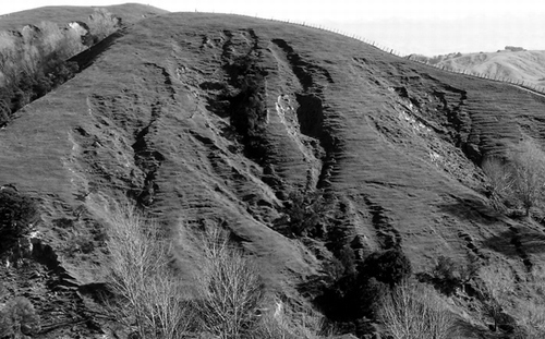
Figure 1 The south-facing (shady) hillslope in the study catchment. Extensive areas of soil slipping are a feature of this landscape and hillslopes have a complex pattern of different-aged soil slip erosion scars.
Land use capability (LUC) classes are VI and VII, with moderate to severe erosion limitations to pastoral use. The LUC classification system is an assessment of the land's capacity for sustained productive use and takes into account physical limitations, soil conservation needs and management requirements of the land (SCRCC Citation1974). The LUC classification system has been used throughout New Zealand to assess the capacity of land to permanently sustain productive use (NWSCO Citation1979). Average annual rainfall is ∼1075 mm and mean annual temperature ranges from 18°C in January to 7.5°C in July. Climate is overall seasonally dry, with frequently occurring summer droughts. There was no severe drought during the 1979–1981 trial (Lambert et al. Citation1984); however, severe drought conditions were experienced in the summer of 2007–2008, which was within the period pasture production was measured in this trial.
Measurement of pasture DM production
Sampling in 1979–1982
Trustrum and Stephens (Citation1981) assigned ages to the landslip scars on hillslopes from archived aerial photographs. Landslip scars were dated as pre-1941, 1941, 1961 and 1977. In the original trial, Lambert et al. (Citation1984) selected 40 measurement sites on these scar ages, as well as five sites on uneroded ground. Sites were located at Te Whanga and Kumukumu stations, near Gladstone, Wairarapa; however, only data from Te Whanga were used in this analysis. Slopes at the measurement sites ranged from 27 to 33° and sites were split between slopes with shady and sunny aspects.
Sites were monitored for DM pasture production from August 1979 to August 1982. DM pasture production was estimated using one 0.5 m2 stock-exclusion cage per site. Pasture was trimmed to 5–10 mm with hand shears every 4–10 weeks depending on the growth rate. The cages were shifted to new nearby locations after each sampling. DM production and botanical composition were determined at each harvest. Rainfall data came from the NIWA-operated Gladstone rain gauge at Te Kopi, which can now be downloaded from the internet (NIWA Citation2010). Temperature data were obtained from the Waingawa climate station, which can similarly be downloaded from the NIWA website.
Sampling in 2007–2009
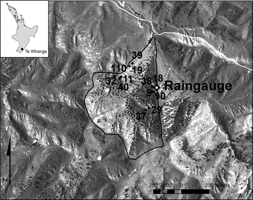
The landslide scars known to have been initiated during storms in 1941, 1961 and 1977 were re-located. The authors were unable to re-locate any pre-1941 slip scars that had not re-activated. For each of these three landslide events, two representative scars were selected. Pasture DM production was measured at each of the six sites using two 0.5 m2 stock-exclusion cages located within the scar itself and two cages placed on adjacent uneroded ground (control) with similar slope and slope aspect, giving a total of 24 cages. The locations of the sites are shown in .
Figure 2 Location of pasture DM production monitoring sites within the study catchment at Te Whanga station. The drainage basin of the study catchment is delineated and the location of the rain gauge shown. The monitoring site numbers are also shown.
The trial was conducted from June 2007 to August 2009. Pasture was harvested with electric hand shears at intervals of 6–8 weeks during winter and 3–4 weeks during summer. The cages were shifted to new nearby locations after each sampling. Pasture botanical composition was visually estimated in December 2007 and percentages of grass, clover and weeds were estimated. A tipping bucket rain gauge was also installed at the site.
Soil sampling and chemical analysis
In the original pasture production trial, Lambert et al. (Citation1984) sampled topsoils for laboratory characterisation. The exact same sites (erosion scars and uneroded sites) were subsequently re-visited at different times over the last 25 years by numerous researchers investigating additional aspects of the chronosequence ().
Table 1 Chronology of sampling at Te Whanga
Sampling in 1981
In 1981, seven sites were chosen for full laboratory characterisation (Lambert et al. Citation1984). Soils were sampled to a depth of 10 cm by taking 6×2.5 cm diameter cores from each site. Samples from each site were combined and analysed for total N, organic C, organic P, inorganic P and Olsen P. Total N was determined by Kjeldahl digestion, organic C by the Walkley and Black procedure, and P fractions as reported by Blakemore et al. (Citation1987). The sites were part of the original pasture production trial conducted from 1979 to 1982 by Lambert et al. (Citation1984) and were also being monitored for soil moisture.
Sampling in 1984
Soil profiles at the same sites (four eroded and two uneroded) were sampled by soil horizon, to the upper C-horizon (62–78 cm depth), for chemical and physical characterisation according to the National Soils Database. The same soil chemical properties as sampled in 1981, for the A-horizons only, were used in this study.
Sampling in 1987 and 2001
In September 1987 and May 2001, surface soil samples (30 pooled cores, 0–10 cm depth) were taken from the same landslip scars from below the head of the scar (Sparling et al. Citation2003). Soils were analysed for chemical and biochemical characteristics (refer to Sparling et al. (Citation2003) for details).
Sampling in 2007
Soil cores were collected in May 2007 from each of the replicated 1941, 1961 and 1977 landslide scars and from adjacent uneroded sites. Surface soil samples (0–10 cm) were collected using a 2.5 cm diameter tube auger. For each site, 40 soil cores were collected at random, bulked and mixed prior to chemical analyses. Areas such as stock tracks and camps were avoided. Soils were analysed for pH, total C, total N, Olsen P, exchangeable bases (Ca, Mg, K, Na), cation exchange capacity (CEC) and base saturation (BS) using methods outlined in Blakemore et al. (1987).
Topsoil depths were measured using a 2 cm diameter soil corer at each site along two transects aligned parallel to the hillslope. At each site, 40 measurements were made at 20 cm intervals along the transects.
Precipitation and climate data
Daily rainfall data for the Te Kopi meteorological station, which lies 3 km to the west of the study catchment, were downloaded (NIWA 2010) for 1979–1982 and 2007–2009 trial periods. Temperature data were not available from this station. Daily mean and maximum temperatures, as well as minimum grass temperature data for 1979–1982, were obtained from the Waingawa climate station and data for 2007–2009 were obtained from the East Taratahi AWS climate station; both climate stations are within a 5 km radius of the study catchment.
Statistical analysis
The recovery of pasture production was modelled using a two-parameter exponential relationship of the form:
The recovery of topsoil characteristics was modelled using the relationship:
where t is the age of the landslip scar and i the sampling time (1987 or 2001). The increasing curve passes through zero when t=0 and rises to an asymptote A i . The decreasing curve passes through A 0 when t=0 and falls to the asymptote A. The constant k controls the rate at which the curve rises or falls. The model was first fitted to scar sites only and then re-fitted to all data points (including non-slipped sites). The goodness of fit of the two models was compared using the analysis of variance (ANOVA) function in GenStat version 6.2.0.235 (Payne et al. Citation2002). The model reflects the necessary condition that at t=0 there is no pasture production because all of the topsoil has been removed. Nominal ages of uneroded sites are based on deforestation and conversion to pasture in 1860. The model was fitted using a non-linear mixed effect model (NLME procedure) in R (version 2.7.0). While the asymptote model is more complex than the single logarithmic fits used by Trustrum and De Rose (Citation1988) and Singh et al. (Citation2001), it has the advantage that it places a limit on the degree to which a property can recover whereas the logarithmic model projected through time predicts an increase to infinity (Sparling et al. Citation2003), which is an unrealistic condition for the properties investigated here.
Analysis of variance was performed on all pasture DM production data and soil chemical characteristics in GenStat version 6.2.0.235 (Payne et al. Citation2002) with a significance level of P<0.05. Log10 transformation was used to correct for heteroscedasticity (an increase in variance with increase in fitted values). Interactions between pasture DM production and eroded versus uneroded, slope aspect, slip date, season, and average rainfall and temperature were tested as different treatments within the ANOVA function. The same ANOVA procedure was used to test interactions between soil chemistry characteristics and pasture DM production. Means and standard errors were compared for the various treatments.
Results
Recovery of pasture DM production
Average annual pasture DM production results for the two trials are listed in and shown in and 4. Standard deviations are high because of the variability of pasture production through the year. There was insufficient data to determine if botanical composition had changed between the two trials.
Figure 3 Seasonal fluctuation in average annual pasture DM production on all sites (eroded and uneroded) from 1979–1982 and 2007–2009. The figure shows overall production on the hill country landforms represented by this study. Vertical lines represent standard error of the mean (n=24 for 2007–2009; n=26 for 1979–1982).
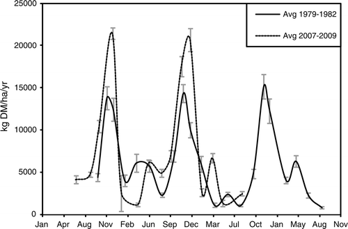
Table 2 Summary of average annual pasture DM production on erosion scars and adjacent uneroded sites.
On uneroded sites, average annual production was 8760 kg DM/ha for this trial compared with 9490 kg DM/ha for the earlier (1979–1982) trial. Although not statistically significant, the results suggest a slight decrease in DM production between surveys, probably due to seasonal effects (see later). For uneroded sites, shady sites had greater average production than sunny sites. Pasture DM production on shady sites was roughly twice that on sunny sites in summer and autumn, and a third greater on sunny than shady sites in winter.
On eroded sites, average annual production was 6716 kg DM/ha for this trial compared with 5803 kg DM/ha for the earlier (1979–1982) trial (SED=537 kg DM/ha per year, n=621). Thus the results suggest an increase in DM production between surveys for eroded sites. As a consequence, DM production on landslides scars as a percentage of uneroded levels has increased over the two survey periods from 63 to 76%. The latest survey did not include young (3-year-old) scars and this probably accounts for most of the increase in relative production on scars as a whole. In contrast to uneroded sites, on eroded sites there was no significant difference in production between sunny and shady sites.
The results of this trial indicate that no improvement occurred on the 1941 and 1961 scars (). Furthermore, there is no significant difference in DM production with scar age in this trial. The only scars that showed a significant improvement in production were the 1977 scars, where DM production increased from about 21 to 81% of uneroded levels. When growth data are combined from both surveys, it is clear there is no significant change in DM production for scars older than about 20 years in age ().
Figure 4 Comparison of DM pasture production on erosion scars (left) and production on erosion scars as a percentage of uneroded levels (right) between the two trials. The vertical bars are 95% confidence limits.
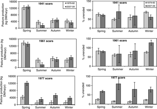
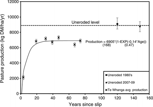
Figure 5 Pasture DM production recovery curve from the 66-year chronosequence of landslide scars (crosses) at Te Whanga station using data from both trials. Each point represents the average production for each scar age. The uneroded sites were not used for curve fitting and are shown for reference at the nominal ages assigned assuming deforestation and conversion to pasture in 1860. Vertical lines represent the SEM (n=621) and values in brackets are the SE of the parameter estimates. The relation accounts for 95.9% of the variance in pasture production (F prob<0.001).
Rainfall and temperature
Climate conditions during the two trial periods were generally similar. Daily precipitation and temperature data for the two trials are compared in . There was very good linear correspondence between the rain gauge used in this study and the Gladstone rain gauge at Te Kopi (R 2=0.986). The only significant differences between the two trial periods were colder daily minimum and grass temperatures in summer during the 2007–2009 trial (t-test, α=0.5). Although not statistically significant, there were some important differences in climatic conditions that may account for differences in pasture production between the two trials. The months from December to February were taken to represent summer, and September to November as spring. Although the summers during both trials experienced similar amounts of precipitation, mean summer maximum daily temperatures were warmer (by 1.2°C) in the 2007–2009 trial, and it was also hotter (by 1.6°C) and drier in autumn (by 65.7 mm) and spring (by 38.1 mm). Overall, there was less rainfall during the 2007–2009 trial (2.1 mm/day versus 2.7 mm/day) and, combined with hotter maximum temperatures (18.5°C versus 17.8°C), this probably caused a sustained period of soil moisture deficit which accounts for the reduced DM production on uneroded sites in the latest trial.
Figure 6 Daily rainfall and temperature data for the two trial periods.
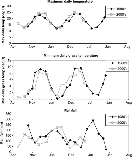
As expected, seasonal variation in temperature and rainfall, along with implied differences in day length, was the main control on pasture growth rate at Te Whanga. Maximum growth rates were experienced in spring and autumn, and minimum levels of production were noted in summer and winter (). The differences between eroded and uneroded sites were greatest in spring and autumn, the seasons when maximum grass growth is crucial to ensure sufficient feed to carry stock over in to summer and winter. Differences in pasture DM production between the two trials were greatest in spring and summer. Spring growth was significantly greater during the 2007–2009 trial, but summer growth was greater in the earlier trial.
Recovery of topsoil characteristics
The recovery of soil chemical characteristics for total C, total N, exchangeable bases (Mg, Na), pH and the ratio of C/N of topsoil (0–10 cm) from erosion scars and adjacent uneroded sites are illustrated in . Soil chemical properties that increased with time since slipping were C, N and C/N. Soil chemical properties that decreased with time since slipping were Mg, Na and pH. There were no clear trends over time for exchangeable Ca and K, CEC, BS or Olsen P. There was a high degree of variability in the Olsen P values: the range was from 6 to 48.3 mg/kg, with both the highest and lowest values recorded at eroded sites. There was no difference between Olsen P values on eroded sites between 1984 (mean=16.9±8.3 mg/kg, n=7, SEM=3.1) and 2007 (mean=21.9±7.8 mg/kg, n=24, SEM=1.6). There were some high Olsen P values in 1984 (38–48 mg/kg) that most likely reflect increased application of P-fertilisers (e.g. superphosphate) at this time. There was also no difference in Olsen P between eroded (mean=15.1±7.8 mg/kg, n=28, SEM=1.5) and uneroded sites (mean=15.9±7.1 mg/kg, n=18, SEM=1.7). The high variability in Olsen P values probably reflects the uneven distribution of P-fertilisers from aerial topdressing and the complex nature of soil properties in hill country pastures. Sparling et al. (Citation2003) also reported no relationship between Olsen P and scar age along the chronosequence. There was no clear relationship between botanical composition and total N.
Figure 7 Recovery curves of key topsoil chemical characteristics from the 66-year chronosequence of landslide scars (diamonds) at Te Whanga station. Data from all years of sampling were used to derive the curves. The uneroded sites (triangles) were not used for curve fitting and are shown for reference at the nominal ages assigned assuming deforestation and conversion to pasture in 1860.
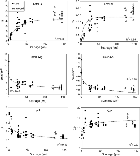
Total C and total N showed a marked increase with slip age. Total C increased from 0.21% in 1-year-old erosion scars to 4% in 66-year old erosion scars (R 2=0.61). The average total C for uneroded sites was 5.4%. Total N also increased from 0.03% in 1-year old erosion scars to an average of 0.34% in 66-year-old erosion scars (R 2=0.55). The ratio of C/N correspondingly increased from 6 to 12 over the 66-year period. Total N and C/N ratio were 0.4% and 11.8 respectively on uneroded sites. The C/N ratio showed a rapid recovery, reaching 90% of the uneroded values within 11 years of slipping. Sparling et al. (Citation2003) reported an even faster rate of recovery for the C/N ratio— recovering to 90% within 5 years and reaching maximum recovery of 92% of uneroded values after 59 years. Soil pH of the youngest erosion scars were high to very high—6.8 and 8.2 from scars formed in 1981 and 1986 respectively—reflecting the calcareous nature of the parent material. Soil pH decreased with scar age to around 5.5, about the same pH of uneroded sites, as a result of leaching and the build-up of acidifying organic matter. The recovery of total C over time is described by the model:
Results of the curve fitting to total C data () indicate that the goodness of fit was not improved by employing an asymptote at a lower level than the uneroded sites. Although there appears to be quite a difference between the curves, there is no evidence to suggest one curve fits better than the other. This infers that there is no evidence in our data to suggest total C in topsoils on eroded sites is trending towards recovery to a lower level than the uneroded sites (P=0.5653). Intercepts did not differ from zero and there was no difference between shady and sunny slope aspects.
Figure 8 Results of curve fitting to total C. The upper curve shows a single line fitted to sites of all ages (eroded+uneroded) (P=0.50) and the lower curve is fitted to the slipped sites, unconstrained by the uneroded sites (P=0.56). Values in brackets are the SE of the parameter estimates. Uneroded sites are plotted at the nominal ages assuming deforestation and conversion to pasture in 1860.
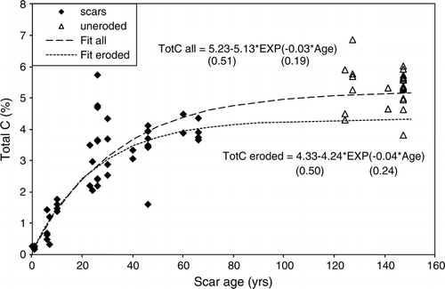
In 2007, total C on 66-year-old landslips had reached 76% of the uneroded values. Sparling et al. (Citation2003) reported that soil C on 23- and 37-year-old landslide scars recovered to ∼ 50% and 72% respectively, compared with soils from adjacent uneroded sites. There was no evidence in our data to suggest that recovery of total C on erosion scars had reached a maximum (i.e. further recovery can be expected) or that recovery was expected to a lower value than on uneroded sites in the long term. After 60+years of recovery, soil pH and C/N ratio had recovered to uneroded values, within the error limits (see ). However, most of the characteristics indicative of soil nutrient status (C, N, P, Mg, K, Na, BS) had recovered to just 75–80% of the uneroded values. There were no clear trends through time for exchangeable Ca and K, CEC or Olsen P.
Table 3 Recovery of topsoil characteristics on erosion scars compared with uneroded soil for 60–66 years and 40–46 years of recovery (when sampled in 1984). Olsen P is omitted from the table because there was no significant difference between eroded and uneroded sites.
Topsoil depth
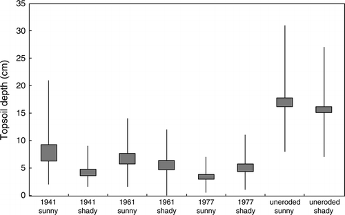
In 2009, the average topsoil depth was 5.9±3.4 cm (n=320) on landslide scars and 16.3±4.5 cm (n=320) on uneroded sites (). Depth to bedrock was 45 cm at scar sites and 98 cm at uneroded sites (in the 1980s). Most landslides were initiated at the interface between the subsoil and siltstone (Vincent & Milne Citation1990). Much of the subsoil remained through displacement downslope, mixed with some topsoil. Typically about 50 cm of subsoil remained at most scar sites (Vincent & Milne Citation1990). Field observations suggest the entire soil profile to the siltstone bedrock was only generally removed at the head of slips. Unexpectedly, there was no real trend between topsoil depth and scar age (R 2=0.0015); this may be a reflection of the very narrow range of topsoil depths on eroded sites (3.3–8.4 mm). As mean slope increased, topsoil depths decreased, reflecting the increasing incidence of landsliding with increasing slope (Trustrum et al. Citation1990). However, within eroded and uneroded classes there was no relationship between topsoil depth and slope.
Figure 9 Box and whisker plot of topsoil depths on slip scars and uneroded sites measured in 2008. Topsoil depth was measured as the depth to the base of the A- plus A/B-horizons. The box represents the 95% confidence limits about the mean and the whiskers represent the maximum and minimum topsoil depths. Data were derived from 40 measurements per erosion scar; uneroded data were derived from 160 measurements on each slope aspect.
Soil profile descriptions of 1981 scars at Te Whanga described in 1984 by Vincent and profiles of the same scars described in this study were compared (NSD, Landcare Research Citation2008). On 7-year-old scars there was virtually no soil development, and on 23- and 26-year-old scars there was 5–6 cm of topsoil development. The profiles illustrate the development of an Ah-horizon over time since slipping at an average rate of approximately 2.2 mm/year. These topsoil development rates are based on horizon depth only and do not include a measure of topsoil maturity.
Relationship between pasture production and soil characteristics
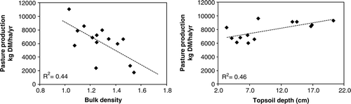
Pasture DM production on eroded sites is related to the recovery of topsoil characteristics. While there were significant differences in topsoil depths and bulk density between eroded and uneroded sites, and weak trends of increasing production with decreasing bulk density and increasing topsoil depth (), due to high variability and small sample sizes there were no statistically significant trends identified between pasture production and topsoil depth (F prob=0.500) or bulk density (F prob=0.216) at eroded sites. No significant interaction was indicated between pasture production and depth to siltstone.
Figure 10 Interaction of pasture DM production with bulk density and topsoil depth for all sites.
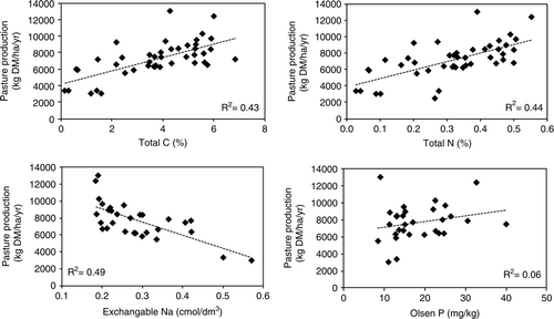
The relationship between pasture production and soil C and N was evaluated because of their influence on soil physical properties (through organic matter) and nutrient status, respectively. Significant relationships between soil chemical characteristics and average pasture DM production were observed for total C, total N and Na (). Total C was the only highly significant interaction (F prob<0.001), but strong relationships were also apparent with total N (F prob=0.002) and Na (F prob=0.011). There was a weak trend of increasing pasture production with increasing Olsen P (), however this relationship was not statistically significant (F prob=0.451). The notable absence of a relationship between Olsen P and pasture DM production in our data is most likely a reflection of the high variability of Olsen P values (6–48.3 mg/kg) rather than an indication that P was not limiting plant growth. The relationship between exchangeable Na and pasture production is probably coincidental. Exchangeable Na was very low compared with other bases. It is being leached to the subsoil, showing a rapid decline over time that mirrors the increase in pasture production. The high levels of Ca, Mg and Na in young scars reflect the rejuvenation of cations from the newly exposed parent material (siltstone). Soil characteristics on newly exposed landslide scars were generally very similar to those on the non-slipped sites at 50–60 cm depth (Sparling et al. Citation2003).
Figure 11 Interaction of pasture DM production with total C, total N, Olsen P and exchangeable Na for all sites.
Discussion
Pasture recovery
In the first study on the recovery of pasture production and topsoil characteristics following landsliding, Lambert et al. (Citation1984) found that young slip scars were producing ∼20% of the pasture DM yields of uneroded ground and that scars revegetated rapidly over the first 20 years, reaching 70–80% of original production. But further recovery was slow and they concluded that complete recovery might not occur in human lifetimes. The study reported here confirms Lambert et al.'s (1984) conclusion, with the oldest (1941 and 1961) slip scars showing no significant improvement in pasture production after a further 25 years. Pasture DM production on the 1977 scars (which were 3-years old in the original survey) increased from an average of 20 to 80% of uneroded levels between the two trials, further confirming results of the earlier study.
Although there were significant differences between pasture DM production on eroded and uneroded sites, in contrast to the results of the first trial, no significant relationship was found between pasture production and slip age in this trial. The most likely explanation is that all scars in our trial were greater than 20 years old, whereas 3-year-old scars were included in the earlier trial and these had minimal pasture growth rates, averaging just 7 kg DM/ha per day. Regression of slip age versus pasture production revealed that the recovery of slip scars reached a maximum at about 20 years and beyond that, further recovery was very slow. Furthermore, a wider scar age range was studied in the earlier trial, with slip ages ranging from 3 to 74 years, whereas the age range of slips in the latter trial was 27–67 years.
Average slope of eroded and uneroded sites was 33° and 26° respectively. Lambert et al. (Citation1984) and De Rose et al. (Citation1995) applied a slope correction factor to account for declining production rates with increasing slope. De Rose et al. (Citation1995) showed that DM production varied for different parts of the landscape in Taranaki where lower slope positions had significantly higher mean production than middle and top slope positions. For whole hillslopes, declines in annual pasture DM production were small below 28°, where few landslides occur, and increased with increasing slope above 28° (De Rose et al. 1995). At Te Whanga, there was a weak relationship between pasture DM production and slope, although the interaction was not significant at the 0.05 significance level (F prob=0.599). Average production declined at the rate of –207 kg DM/ha per year per degree slope increase. Application of this slope correction factor suggests the average relative production at eroded sites could be higher (i.e. 82%), but due to the lack of statistical significance, as with Lambert et al. (Citation1984), no correction was applied.
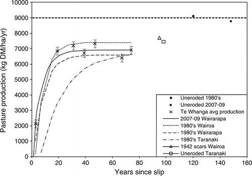
Comparison of pasture recovery curves from this study with the results from earlier research (Lambert et al. Citation1984, Douglas et al. Citation1986, De Rose et al. 1995) indicates that scars are recovering to similar levels in Taranaki, Wairoa and the Wairarapa (). De Rose et al. (1995) showed that Taranaki scars recovered at a slower rate than scars in Wairarapa and Wairoa, but some scars in Taranaki (without a soil moisture deficit) had recovered to uneroded levels after 80 years. De Rose et al. (1995) attributed the slower rate of pasture recovery in Taranaki to differences in landslide morphology. In Taranaki, landslides tend to remove most soil down to the harder sandstone bedrock. In Wairarapa and Wairoa, landslides typically occur in the B-horizon, leaving a significant depth of weathered regolith: several landslide events are required to remove soil to the softer siltstone or mudstone. The recovery of pasture production may also be related to the profile available water capacity of the soils. De Rose et al. (1995) showed that at sites in Taranaki where soil moisture status did not limit pasture growth, pasture production recovered to uneroded levels after 80 years. However, at sites where soil moisture conditions limited plant growth, recovery of pasture production was limited to about 74% (similar to production on 40-year-old scars). This has important implications for the recovery of landslide scars in the seasonally dry Wairarapa, where soils are subjected to severe moisture deficits in summer and autumn. Summer droughts also are common in Wairoa, where pasture DM production recovered to similar levels as in Wairarapa (Douglas 1986). The severe moisture deficits potentially prevent pasture production from returning to uneroded levels in Wairarapa and east coast hill country.
Figure 12 Comparison of pasture DM recovery curves from Wairarapa, Taranaki and Wairoa. Pasture DM production at uneroded levels sites in Wairarapa and Taranaki are shown for comparison. Vertical bars represent the standard error of the mean (n=621).
Recovery of topsoil characteristics
The recovery of pasture production was linked to the recovery of topsoil physical and chemical properties of eroded soils by Lambert et al. (Citation1984), who concluded that reduced pasture production on erosion scars was most likely due to the dense clay-rich substrates with high bulk densities that were exposed by erosion. Sparling et al. (Citation2003) reported that bulk density and particle density on the same slip scars decreased with slip age, although they did not find any corresponding trend over time for porosity or available water for individual soil samples. Preliminary analysis of unpublished neutron probe data (K. Vincent, personal communication) collected from 1981 to 1983 from the same sites at Te Whanga showed that more water could be extracted from uneroded sites. A more thorough analysis of the dataset is required to confirm and validate this finding and to relate it to pasture production; however, it is likely that reduced profile available water capacity of the eroded soils may also limit plant growth (De Rose et al. 1995).
The average rate of topsoil development on landslide scars at Te Whanga station was approximately 2.2 mm/year. Trustrum and De Rose (1988) reported a rate of topsoil development in Taranaki hill country of 3.5 mm/year for the first 40 years following landsliding, followed by a rate of 1.2 mm/year for the next 50 years. Smale et al. (Citation1997) reported an even faster rate (6.4 mm/year) of topsoil development on landslide scars in the East Cape region, where scars had been colonised by kanuka (Kunzea ericoids var. ericoides) scrub. Differences in mean annual rainfall (MAR) and the underlying rock types are the likely reason for the differences in rates between the study sites. Te Whanga has a seasonally dry climate, with a MAR of 1075 mm/year, whereas the Taranaki study site at Makahu has a MAR of 1837 mm/year, almost twice that of the Wairarapa site. MAR in the East Cape region is 1200–1600 mm/year (Smale et al. Citation1997). Mean annual temperature is within the range 12–14°C at all three sites (MetService, Citation2010) Retrieved September 12, 2010 from http://www.metservice.com/). Despite differences in the underlying geology (harder sandstone in Taranaki, siltstone in the Wairarapa and mudstone in East Cape) and landsliding depth, soil development appears to proceed at a faster rate in Taranaki hill country compared with the Wairarapa, most likely due to the higher rainfall. Smale et al. (Citation1997) attributed the substantially faster rate of soil development on slip scars re-colonised by scrub in East Cape to the rapid weathering of the underlying bedrock mudstone, through desiccation and frittering and headwall collapse of the highly pedal mudstone.
Lambert et al. (Citation1984) and Sparling et al. (Citation2003) estimated that recovery of topsoil chemical characteristics on landslide scars in Wairarapa hill country would reach 80% of uneroded sites over a timescale of 18–80 years. Sparling et al. (Citation2003) showed that biochemical characteristics recovered at a much faster rate than chemical or physical characteristics. Our data confirm these earlier findings: after 60+years of recovery, soil pH and C/N ratio had, within the error limits, recovered to uneroded values (see ). However, most of the characteristics indicative of soil nutrient status (C, N, Mg, Na, BS) had recovered to just 75–80% of the uneroded values and it is these components, coupled with reduced water-holding capacity, that are ultimately limiting recovery in pasture growth at eroded sites. Correlation between levels of available soil nutrients (particularly P, N, K and S) and pasture production on hill country is well established; there are, however, other factors that may override these general relationships at a micro-site level. In our study it was most likely soil moisture availability. Unpublished neutron probe data measured at the same sites as this study from 1981–1983, indicate that more water could be extracted from uneroded than eroded sites (K. Vincent personal communication).
Although total C on uneroded sites was significantly greater than on eroded sites, there was no evidence in our data to suggest that recovery of total C on erosion scars had reached a maximum (i.e. further recovery can be expected) or that recovery was restricted in the long term to having a value less than uneroded sites. However, as the original soils were formed under forest, with inputs of organic matter over a very long period (hundreds to thousands of years) followed by about 150 years of pasture inputs, the new soils being formed under pasture are unlikely to reach uneroded levels of soil C within a few decades, based on the carbon turnover rates and levels of inert soil carbon reported by Tate et al. (Citation1995). Soil C stocks on eroded sites are likely to remain diminished compared with uneroded levels because of reduced topsoil and subsoil depths, and the different organic matter compositions found under pasture and forest (Beets et al. Citation2002). The original uneroded soils were formed under forest and typically included the build-up of litter and humus in the topsoil. New Zealand hill country pastures developed on forest soils have benefited from an additional 100–150 years of soil formation under pasture. The introduction of exotic worm species caused a thorough mixing of the litter and humus, mostly in the top 20 cm of the mineral soil but with some subsoil incorporation by deep burrowing worms resulting in improvements in soil structure, soil hydraulic characteristics and production (Yeates Citation1991). Some subsoil carbon also accumulates from movement and deposition down the profile of dissolved organic matter. Build-up and translocation down the profile of organic matter under pasture on eroded sites is a long-term process. Hence, although the top 0.1 m of soil may have organic matter levels approaching those of the original forest soils, the soil C content of uneroded sites will be greater when the soil profile is sampled to greater depths. For example, Beets et al. (Citation2002) reported a statistically significant, though weak, land use by depth interaction at Purukohukohu experimental basin in the central North Island: surface soil under pasture contained more, and sub-surface soil less, soil C than under forest. Although soil C content was higher in the top 0.1 m of topsoil under pasture at Purukohukohu, the soil C content was greater under the native forest when the profile was sampled to greater depths. Soil C in forest soils may be more recalcitrant and less available for decomposition and nutrient supply to plants, but the uneroded soils also had ∼150 years of soil formation under pasture.
Total C recovered at a similar rate, but to a higher level than modelled by Lambert et al. (Citation1984). If the model describing soil C recovery over time on slip scars is unconstrained by soil C levels at uneroded sites, our data indicate recovery of C to 74% of uneroded levels within about 60 years. Lambert et al. (Citation1984) predicted soil C recovery to 60% of uneroded levels within about 40 years, but no further recovery was expected. Sparling et al. (Citation2003) also indicate recovery of C to about 76%. Addition of the new data has shown that soil C levels have increased slightly since the 1980s, but are unlikely to attain soil C levels on uneroded sites for a long time.
Influence of soil properties on pasture production
Pasture DM production on slip scars increased in proportion to improvements in soil chemical and physical properties associated with soil formation processes on the bare slip scars. Improved pasture production was correlated with the build-up of soil C, N and other indicators of soil nutrient status (K, Na, etc.) and physical properties. Although interactions between pasture production and topsoil depth and bulk density at eroded sites were statistically weak (due to the variability and small sample numbers), the relationships between topsoil depth and bulk density with production were evident when both eroded and uneroded sites were compared. This suggests that soil physical properties, through their influence on profile available water, are also limiting plant growth on erosion scars.
Lambert et al. (Citation1984) attributed the lower pasture productivity on younger erosion scars to the physical properties of eroded soils rather than to soil chemical factors. They concluded that reduced pasture production on erosion scars was most likely due to the dense clay-rich substrates with high bulk densities that were exposed by erosion. Soil physical characteristics were not re-measured in this study (2007–2009); however, Sparling et al. (Citation2003) reported that bulk density and particle density decreased with slip age.
Moir et al. (Citation2000) identified soil moisture, climate and soil fertility as the three major factors influencing annual pasture production in a modelling exercise using field trial data from nearby Wairarapa hill country farms (at Whareama, Gladstone and Mauriceville). Moir et al. (Citation2000) did not include eroded sites in their study. Our data suggest that erosion, through the loss of soil (particularly topsoil), directly affects the soil moisture-holding capacity through reduced topsoil and subsoil thicknesses and organic matter content, which also affects the soil nutrient status. Soil erosion is thus another important factor influencing annual pasture production in New Zealand hill country.
Implications
These research results have implications for the long-term sustainability of pastoral farming on steeper slopes underlain by poorly consolidated parent materials. In a survey of catchment condition at Te Whanga, Stephens et al. (Citation1983) showed that the hillslope units studied in this project occur within landforms that represent 56% of the total area of Te Whanga station and Trustrum et al. (1983) determined that the overall loss in potential pasture production on these hillslopes was 18%. It is likely that this number has increased because of the cumulative effects of new landslide scars in the study area over the last 25 years. This has the potential to represent a significant loss in pasture production resulting from soil erosion for stations such as Te Whanga. The landslide scars are expected to heal with time but not to uneroded soil levels in human timescales.
Landsliding has the potential to cause significant losses of soil C from the landscape. Baisden et al. (Citation2002) estimated the removal of 36–90 Mg C/ha between 1984 and 2001 from Te Whanga station alone. They also indicated the importance of quantifying the recovery of soil organic matter on erosion scars when accounting for C losses due to soil erosion. Soil erosion also has the potential to affect the spatial distribution of soil C stocks in the landscape through the translocation and deposition of debris flow/colluvial material. It was estimated that 50% of sediment generated by shallow landslides in the Te Arai catchment (East Coast) remained on the hillslopes (Page et al. Citation1999). The fate of redistributed soil C through erosion remains unclear and the mineralisation rate of exposed C in soil aggregates and buried C is the focus of this debate (Yadav & Malanson Citation2009). At present, organic matter levels and soil C distributions in reworked and buried material are unknown, as is their change with time.
Climate change is expected to increase drought risk in the Wairarapa (Mullan et al. Citation2005). By 2080, severe droughts (defined as 1-in-20-year droughts) in the Wairarapa are projected to occur at least twice as often as they occur now under NIWA's low–medium climate-change scenario and four times as often under the medium–high scenario. Both the severity and frequency of droughts are expected to increase. The occurrence of a soil moisture deficit in summer and autumn prevented pasture production from returning to uneroded levels on landslide scars in Taranaki hill country (De Rose et al. 1995). Furthermore, the magnitude and frequency of very heavy rainfall events may also increase, even in areas where average annual rainfall decreases (Mullan et al. Citation2005), possibly leading to an increase in landslide-triggering events. We do not know how climate change will affect the rate of topsoil and pasture production recovery on landslide scars; however, the increased incidence of drought may reduce the rate and level of pasture recovery in drought-prone hill country areas of New Zealand.
Conclusions
Topsoil properties and pasture DM production on landslide scars in the Wairarapa have recovered to about 80% of uneroded levels after 66 years; this would seem to verify the conclusion of Lambert at al. (1984) that pasture recovery on landslide scars beyond 80% was unlikely. A gradual increase in production on older scars was also suggested by the exponential pasture recovery curves. This research found that no additional improvement in production occurred after a further 25 years of recovery of the oldest (1941 and 1961) slip scars at Te Whanga. Average DM pasture production on eroded sites increased from 63 to 78% of uneroded levels, but improvement was limited to the youngest slip scars (3-years-old in the first trial). Maximum pasture recovery occurred within about 20 years; beyond that there was no evidence of further recovery. The exponential form of the pasture recovery curve of Lambert et al. (Citation1984) was also confirmed. It is unlikely that pasture production on slip scars will return to uneroded levels within human lifetimes.
The recovery of pasture DM production was accompanied by similar increases in soil C and N, which had reached 76 and 78% respectively of uneroded values after 66 years. Our results support the conclusions of other researchers (Lambert et al. Citation1984; Trustrum & De Rose Citation1988; Sparling et al. Citation2003) that some soil chemical characteristics (total C, N) may not recover to uneroded soil levels within human lifetimes. However, the data obtained in the current study were inconclusive on whether surface total C would recover to values on uneroded sites in the long term. Other soil properties (C/N, pH, Mg, Na and CEC) are expected to recover to uneroded values within human timescales and are not the cause of permanent reductions in pasture growth on older landslide scars.
The implication of this and previous research is that the sustainability of pastoral agriculture on steeper east coast hill country, which is underlain by poorly consolidated parent materials, will be increasingly under threat from the progressive reduction of pasture production through cumulative erosion.
Acknowledgements
We thank Greg Crombie (Manager of Te Whanga station) for access and helpful discussions about farm management, Guy Forrester for statistical analysis, Ron De Rose and Allan Hewitt for reviewing the manuscript and providing useful recommendations, Des Costall for help in locating the scars in 2007 and Mike Marden for helping to set up the trial. This research was conducted with funding from the Sustainable Land Use Research Initiative (SLURI), FRST contract no. C02X0405.
Related Research Data
References
- Baisden W , Parfitt R , Trustrum NA 2002 . Are eroding landscapes C sources or sinks: testing the ‘dynamic equilibrium’ hypothesis in highly erodible New Zealand pasture . Proceedings of 87th annual meeting of the Ecological Society of America and 14th Annual International Conference of the Society for Ecological Restoration . Tus con, Arizona. Ecological Society of America. http://abstracts.co.allenpress.com/pweb/esa2002/document/17238 (accessed 17 December 2010). .
- Beets , PN , Olivera , GR and Clinton , PW . 2002 . Soil carbon protection in podocarp/hardwood forest, and effects of conversion to pasture and exotic pine forest . Environmental Pollution , 116 : S63 – S73 .
- Blakemore LC Searle PL Daly BK Methods for chemical analysis of soils New Zealand Soil Bureau, Department of Scientific and Industrial Research Lower Hutt, , New Zealand 103 New Zealand Soil Bureau Scientific Report 80
- Blaschke , PM , Trustrum , NA and De Rose , RC . 1992 . Ecosystem processes and sustainable land use in New Zealand steeplands . Agriculture, Ecosystems & Environment , 41 : 153 – 178 .
- De Rose , RC , Trustrum , NA , Thomson , RC and Roberts , AHC . 1995 . Effect of landslide erosion on Taranaki hill pasture production and composition . New Zealand Journal of Agricultural Research , 38 : 457 – 471 .
- Douglas , GB , Trustrum , NA and Brown , IC . 1986 . Effect of soil slip erosion on Wairoa hill pasture production and composition . New Zealand Journal of Agricultural Research , 29 : 183 – 192 .
- Hart PB , West AW , Ross DJ , Sparling GP , Speir TW 1990 . The importance of organic matter for restoration of soil fertility in drastically disturbed New Zealand landscapes . In : Gregg PEH , Stewart RB , Currie LD Proceedings of conference on Issues in the Restoration of Disturbed Land . Fertilizer and Lime Research Centre, Massey University , Palmerston North . Occasional report no. 4 269 285 .
- Lambert , MG , Trustrum , NA and Costall , DA . 1984 . Effect of soil slip erosion on seasonally dry Wairarapa hill pastures . New Zealand Journal of Agricultural Research , 27 : 57 – 64 .
- Lambert , MG , Trustrum , NA , Costall , DA and Foote , AG . 1993 . Revegetation of landslide scars in Wairarapa hill country . Proceedings of the New Zealand Grassland Association , 55 : 177 – 181 .
- Metservice 2010 . http://www.metservice.com/ ( accessed 12 September 2010 ).
- Moir , JL , Scotter , DR , Hedley , MJ and Mackey , AD . 2000 . A climate-driven, soil fertility dependent, pasture production model . New Zealand Journal of Agricultural Research , 43 : 491 – 500 .
- Mullan B , Porteous A , Wratt D , Hollis M 2005 . Changes in drought risk with climate change . : Prepared for Ministry for the Environment (NZ Climate Change Office) and Ministry of Agriculture and Forestry NIWA Client Report: WLG2005-23
- NIWA (National Institute of Water & Atmospheric Research) 2010 . http://cliflo.niwa.co.nz/ (accessed 17 December 2010 ).
- NSD, Landcare Research 2008 , http://soils.landcareresearch.co.nz/contents/SoilData_NSD_About.aspx (accessed July 2008).
- NWSCO (National Water and Soil Conservation Organisation) 1979 . Our land resources, a bulletin to accompany New Zealand Land Resource Inventory worksheets . NWSCO , Wellington .
- Page , MJ , Reid , LM and Lynn , IH . 1999 . Sediment production from cyclone bola landslides, Waipaoa catchment . Journal of Hydrology (NZ) , 38 ( 2 ) : 289 – 308 .
- Parfitt , RL , Roberts , AHC , Thompson , NA and Cook , FJ . 1985 . Water use, irrigation, and pasture production on Stratford silt loam . New Zealand Journal of Agricultural Research , 28 : 393 – 401 .
- Payne R , Murray D , Harding S , Baird D , Soutar D , Land P 2002 . Genstat for Windows , 6th edn Lawes Agricultural Trust , Oxford, , UK .
- RDCT R (Development Core Team) 2009 . R: a language and environment for statistical computing. Vienna, R Foundation for Statistical Computing . http://www.R-project.org (accessed 17 December 2010 ).
- Rosser B , Ross C 2008 . Recovery of topsoil characteristics on landslide scars in erodible siltstone hill country, Wairarapa . Landcare Research Lincoln, , New Zealand 29 Landcare Research Contract Report LC0708/159
- Rosser B , Ross C 2009 . Recovery of pasture productivity on landslide scars in erodible siltstone hill country, Wairarapa . Landcare Research Lincoln, , New Zealand 25 Landcare Research Contract Report LC0910/038
- SCRCC (Soil Conservation and Rivers Control Council) 1974 . Land use capability survey handbook. A New Zealand handbook for the classification of land . SCRCC , Wellington .
- Singh , KP , Mandal , TN and Tripathi , SK . 2001 . Patterns of restoration of soil physicochemical properties and microbial biomass in different landslide sites in the sal forest ecosystem of Nepal Himalaya . Ecological Engineering , 17 : 385 – 401 .
- Smale , MC , McLeod , M and Smale , PN . 1997 . Vegetation and soil recovery on shallow landslide scars in Tertiary hill country, East Cape region, New Zealand . New Zealand Journal of Ecology , 21 ( 1 ) : 31 – 41 .
- Sparling , G , Ross , D , Trustrum , N , Arnold , G , West , A , Speir , T and Schipper , L . 2003 . Recovery of topsoil characteristics after landslip erosion in dry hill country of New Zealand, and a test of the space-for-time hypothesis . Soil Biology and Biochemistry , 35 : 1575 – 1586 .
- Stephens , PR , Trustrum , NA and Hicks , DL . 1983 . Experimental aerial photographic survey of erosion and catchment condition, Gladstone District, Wairarapa . Water and Soil Miscellaneous Publication , 52 : 129 – 154 .
- Tate , KR , Parshotam , A and Ross , DJ . 1995 . Soil carbon storage and turnover in temperate forests and grasslands—a New Zealand perspective . Journal of Biogeography , 22 : 695 – 700 .
- Trustrum , NA and De Rose , RC . 1988 . Soil depth: age relationship of landslides on deforested hillslopes, Taranaki, New Zealand . Geomorphology , 1 : 143 – 160 .
- Trustrum , NA and Stephens , PR . 1981 . Selection of hill-country pasture measurement sites by interpretation of sequential aerial photographs . New Zealand Journal of Experimental Agriculture , 9 : 31 – 34 .
- Trustrum NA , Lambert MG , Thomas VJ 1983 The impact of soil slip erosion on hill country pasture production in New Zealand Proceedings of the second International Conference on Soil Erosion and Conservation, Honolulu, Hawaii, January 1983 SA El-Swaify WC Moldenhauer A Lo Ankerly Soil Conservation Society of America Iowa 1985 . 793 .
- Trustrum NA , Blaschke PM , De Rose RC , West AW 1990 . Regolith changes and pastoral productivity declines following deforestation in steeplands of north Island, New Zealand . Transactions of 14th international soil science congress. International Soil Science Society, Kyoto, Japan, August 1990. Section I : 125 130
- Vincent KW , Milne JDG 1990 . Soil pattern of Te Whanga trail site, Wairarapa: soil landscapes, effects of erosion, and soil amelioration in steep eroded siltstone hill country . Unpublished DSIR Land Resources report .
- Yadav , V and Malanson , GP . 2009 . Modeling impacts of erosion and deposition on soil organic carbon in the Big Creek Basin of southern Illinois . Geomorphology , 106 : 304 – 314 .
- Yeates , GW . 1991 . Impact of historical changes in land use on the soil fauna . New Zealand Journal of Ecology , 15 ( 1 ) : 99 – 106 .