Abstract
Dissolved phosphorus (P) from various sources contributes to periphyton growth in rivers. The Manawatu catchment is in the southern North Island, and since it flows through pastoral farmland with soft rock geology, it carries nitrogen, P and sediment that lead to growth of periphyton. We estimated long-term average sediment P in rivers in the catchment above Palmerston North (PNth) (3910 km2) with the NZeem® model, and also measured the total P on the bed of the river. The annual loss of P in eroded sediment made up 95% of the P flux, (1500 t P yr−1 at PNth); 96% of the erosion occurred under pastures and 4% under forest. Dissolved P was measured at Hopelands and at PNth, and its origins—point sources, forests, the bed of the river and farmland—were assessed. The annual average dissolved P was estimated to be 75 t P at PNth, with 34 t P coming from sheep and beef farms, and this could be reduced with targeted planting of trees; 19 t P came from dairy farms, and could be reduced with changes to management of effluent, limiting soil Olsen P to the optimum agronomic range, and excluding cows from streams, banks and channels. Dissolved P from point sources (15 t P) could be decreased with changes to management of effluent. During low flows, sediment on the bed of the river released approximately 1.3 t dissolved P. These particulate-bound P losses could be reduced by targeted planting of trees on highly erodible land. The Upper Manawatu Water Management Zones (a priority catchment for mitigation) above Hopelands Bridge were also modelled. Council programmes to reduce soil erosion and total P, and to reduce dissolved P during low flow have the potential to reduce P loads in the river. Monitoring of P in the river should be carried out to define a more precise base line, and to monitor improvements to water quality as the programmes progress.
Introduction
Phosphorus (P) is lost from land to waters in three forms—P in suspended sediment particles (PP), dissolved reactive P (DRP) and dissolved organic-P (DOP) (McDowell & Wilcock Citation2008). PP is generated during major storms when soil is eroded on steep land. Some sediment is retained in storage in the channel bed and may subsequently move downstream in future storms (Ballantine et al. Citation2009). Sediment (and the associated P) may also be deposited on floodplains where it may be stored for periods of 10–1000 years or longer (e.g. Ballantine et al. Citation2006) and transferred to the channel through stream bank erosion (McDowell & Wilcock Citation2007). DRP is generated by dissolution of P in rocks, soils and fertilizer, and mineralization of P in soil organic matter; it is readily available to periphyton in rivers. DOP is produced by dissolution of soil organic matter, is less available than DRP and requires biological processing to access this P, and then mineralize the DOP into DRP (McDowell et al. Citation2009). DRP and DOP are produced from both diffuse agricultural sources and point sources (Ledein et al. Citation2007; Clothier et al. Citation2007; Parfitt et al. Citation2009; Roygard et al. Citation2012). DOP is also generated in waters when P is taken up by biological activity. Point sources mainly include industries and waste water treatment plants (WWTP) at townships.
Nutrient mass balances for nitrogen (N) and P have been obtained for large rivers flowing into the Atlantic, with the largest flux of P coming from the Amazon Basin (236 kg P km−2 yr−1), and that mainly arises from sediment eroded from the Andes; for many other rivers a large part of the nutrient load comes from towns and cities (Howarth et al. Citation1996). In contrast, in the Manawatu catchment above Palmerston North (Teacher's College), there are only five small townships, but there is significant erosion in the soft rock geology of the hill country (Dymond & Shepherd Citation2006).
The Horizons Region comprises 22,200 km2 in the southern North Island (Parfitt et al. Citation2008a) (). There is widespread public concern about the health of rivers in the region, and this is being addressed in the One Plan, in the National Land and Water Forum, and in the Sustainable Dairying Water Accord. Horizons Regional Council's sustainable land use initiative (SLUI) addresses erosion on farms and associated sediment in rivers including the Manawatu. A more recent Horizons initiative—nutrient management plans (NMPs)—targets reductions in nutrient loss (mainly N and P) from intensive land uses in priority catchments. Both of these initiatives, which include recommended best management practices (discussed later), form part of the Horizons One Plan. The One Plan, a combined regional policy statement, regional plan and coastal plan, emphasizes integrated catchment management. The One Plan seeks to provide a mechanism to improve water quality, and to reduce N and P concentrations that contribute to the growth of periphyton in the river.
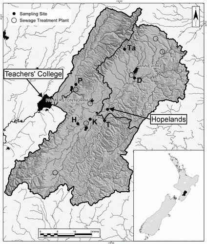
Figure 1 Manawatu Catchment above Teachers' College and the Upper Manawatu Catchment above Hopelands. Scale is 0–24 km. Major sampling sites are Palmerston North Teachers' College; Hopelands; Ta, Tamaki; T, Tiraumea; K, Mangatainoka; H, Mangahao; P, Pohangina; ○, waste water treatment plants.
Little is known about either the amounts or the sources of total-P and dissolved P in the Manawatu River, or about the quantitative effectiveness of mitigation practices on total-P and dissolved P in the river (Parfitt et al. Citation2004; Parfitt Citation2006). In New Zealand catchments, grazing stock, soil-P, fertilizer and forests all contribute to dissolved P in rivers (Hart et al. Citation2004: Elliott et al. Citation2005; McDowell Citation2006; McDowell & Wilcock Citation2007, Citation2008; McGroddy et al. Citation2008; McDowell et al. Citation2009) and sediment is generated from hill country during major storms (Dymond et al. Citation2010). In a preliminary study (Parfitt et al. Citation2008b) with Horizons, the NZeem® and Overseer® models were used to generate data on sediment P and soluble P in the upper catchment in a first attempt to determine the amounts of P from diffuse sources, and the likely merits of proposed mitigation strategies.
Overseer® is an agricultural management tool that assists farmers and their advisers to examine nutrient use and movements within a farm to optimize production and environmental outcomes (AgResearch Citation2009). The computer model calculates and estimates the nutrient flows in a productive farming system and identifies risk for environmental impacts through nutrient loss, including runoff and leaching, and greenhouse gas emissions. It has a P component that predicts the annual loss of P from farmed land (McDowell et al. Citation2005). NZeem® is an empirical model that predicts mean annual sediment yield from a given catchment, based on annual rainfall, type of terrain and percentage of woody vegetation cover; it estimates the average sediment generated in a catchment over an extended period (about 50 years) (Dymond et al. Citation2010) including those major storms that cause erosion to occur on a decadal timescale. If the P concentration in the sediment is known, then the P generated by erosion can be estimated on top of those annual losses estimated at the farm scale by Overseer®. The use of a model such as NZeem® may be required in highly erodible catchments such as the Manawatu River where the P generated by erosion from major storms on a catchment scale (e.g. via slips, etc.) could be missed at the farm scale (Parfitt et al. Citation2008b).
Here we seek to estimate the sources and inputs of P to the Manawatu river, upstream from Teachers' College and Hopelands Bridge, and the losses of P at these major gauging stations. The measured loads from point sources, mainly WWTP, are also reported here. The sediment and PP deposited on the bed of the river after each storm, and the amounts of DRP released to the water were estimated as part of this study. Here we further develop methods to measure the amount of PP on the bed of the river for 2010 and estimate the amount of DRP released. We also measure the load of DRP at the gauging stations for 1989–2009 and assess likely sources of P using Overseer® in each stretch of the river. The quantitative effects of SLUI and NMPs were estimated for the Upper Manawatu Water Management Zones (UMWMZ) (a priority catchment for mitigation) above Hopelands.
Materials and methods
Study site and sampling
Two subcatchments were selected for study: the Manawatu catchment (391,000 ha) upstream from Teachers' College (this is upstream from the Palmerston North WWTP) and the Upper Manawatu catchment (127,000 ha) upstream from Hopelands Bridge, where long-term monitoring data were available. The study area is shown in ; the land use areas were estimated from databases including Agribase, Land Cover Data Base2 and Horizons Dairy/Land-Parcels (Clark & Roygard Citation2008), and are reported in .
Table 1 Land use (ha) from Horizons databases.
Area of river
The wetted area of the rivers in the catchments was measured using Google Earth. Most of the satellite images were taken during low flow, but a small part was taken during a flood, which would slightly overestimate the wetted area at low flow. The ruler provided by Google Earth was used to measure the entire length of the main channel and width selected at regular intervals along it. The wetted area of each river was estimated by the product of length and mean width (estimated from c. 50 cross sections for each tributary). Summation gave the total area of wetted channel in the Manawatu catchment.
Flow data
Flow data for the Manawatu River have been recorded by Horizons for 1989–2009. Hamill (Citation2008) suggests that three times the median flow is approximately the flow needed to turn over river gravels, effectively clearing the stream bed of periphyton, therefore we counted the average number of these events during November–April (three events in summer) and May–October (four events in winter). We assumed that the river bed needs to be stable for at least 20 days to release available P at a maximum rate (Biggs Citation2000).
Sediment and water samples
Depth integrated triplicate samples of sediment in the river were taken at Teachers' College during flood events on 21 and 23 January 2004, 16 February 2004, 21 June 2010, 11 October 2010 and 6 September 2010. Duplicate samples from the bed of the river were taken on 31 March 2010 and 22 April 2010, both during low flow at the end of the summer. No flood occurred between the two samplings. The autumn was dry, and permitted two samplings under similar conditions. Generally, sampling was carried out twice at a site. The Manawatu River was sampled at five different sites and the Tamaki stream near the Ruahine Ranges at two sites. The Tamaki stream was sampled once on 30 March 2010. In total, more than 50 samples of sediment were obtained. Sites were chosen where there were no rapids, no stagnant water and no boulders. GPS positions were recorded.
Bed sampling followed the method of Lambert & Walling (Citation1988). A metal cylinder (height 60 cm; diameter 39 cm) was pushed into the river bed in order to create a seal. The top 10 cm of the river bed was then stirred with a trowel with the water inside the cylinder to remobilize the fine sediments. A representative sample of the turbid water (about 2 L) was collected in a large-neck white plastic bottle. The volumes of water in the plastic bottle and the cylinder were both measured.
Fine sediment samples were flocculated by freezing the suspensions, and then thawing in the dark, and removing water with a siphon. The suspension was dried at 35 °C overnight, and then sieved through a 1 mm sieve and weighed before analysis.
The amount of fine sediment stored per unit surface of river bed (Br, g m−2) was calculated from:
Samples of water from the river were taken at Teachers' College on 75 days in 2004, filtered through a 0.2 µm filter, and DRP was measured, together with DOP on 21 days. Both Teachers' College and Hopelands are long-term monitoring sites for the National River Water Quality Network (NRWQN) and there is a monthly record of DRP in the river since 1989.
Sediment and water analyses
The sediment samples were analysed for inorganic P and total P by the methods of Landcare Research (Citation2010). Organic P was obtained from the difference between the total P and inorganic P. Bicarbonate extractable P used 0.5 M sodium bicarbonate, at pH 8.5, with a 1:20 soil:extractant ratio of 1:20, and with 30 minutes shaking).The 0.1 M NaOH-extractable P fraction can be used to estimate both short- and long-term algal available P in sediments according to Dorich et al. (Citation1985). This extraction method was carried out with an extractant:solids ratio of 500:1 (v/w) for 17 h as described Dorich et al. (Citation1985). P was analysed by the ammonium molybdate colorimetric method on a flow injection analyser. Total P in waters was measured after oxidation with persulphate, and DOP obtained from the difference between the total P and DRP.
Calculation of loads in river bed and in waters
NZeem® (Dymond et al. Citation2010) was used to estimate the suspended sediment load in the Manawatu River from various land uses. These loads were multiplied by the average total P concentration to produce the loss of total P in eroded sediments. The P concentration of the sediment on the bed of the Manawatu River was in the relatively narrow range of 520 to 550 mg kg−1. The average P concentration of sediment samples taken in major flood events was 545 mg kg−1, and we have used this value, assuming that this is representative of the sediment.
The measured data for DRP and total P in the Manawatu River under various flow conditions at Hopelands were supplied from long-term records held by Horizons. For Teachers' College, data for total P and DRP were obtained from the NRWQN data set together with daily mean flows, to determine the average P export between 1989 and 2009. Rating curves were generated by using trend analysis. The function
Overseer® was used to estimate the ‘background’ P losses (kg P ha−1 yr−1) from soil profiles for average dairy farms and sheep and beef farms. These data were based on interviews with a range of representative farmers and their advisers. Overseer® was used for each farm, and these data were then amalgamated, and the means taken, to obtain data for an ‘average’ dairy farm and an ‘average’ sheep and beef farm in the catchment. The data on animal stock units ha−1 and milk solid production for dairy farms in the catchments above Teachers' College were obtained through the Agribase® (2007 data) and Dairy NZ databases (Dymond et al. Citation2013; Ausseil et al. 2013).
Forests with greywacke/sandstone/mudstone geology have spring waters that contain concentrations of close to 5 mg DRP m−3 and 5 mg DOP m−3, and assuming annual leaching of 600 mm, were assumed to lose 0.06 kg P ha−1 yr−1 to headwater streams (McGroddy et al. Citation2008). Since the area of forest has been measured from satellite data, the loss of soluble P from forests (in tonnes) can be estimated. Losses from point sources (tonnes DRP) were obtained from river water samples taken above and below water treatment plants and industries. The losses from forests and point sources were subtracted from the annual flux of dissolved total-P in the rivers, and the remaining tonnes of P in the river (Pf) was apportioned to dairy and sheep/beef farms. The Overseer® model gave a P loss in kg ha−1 for ‘average’ dairy and ‘average’ sheep/beef farms. The ratio (dairy to sheep/beef) of P loss was maintained in the calculations for all the dairy and sheep/beef land (kg ha−1), and this ratio together with the tonnes of P from farm land (Pf) was used to solve the equations to apportion P loss (in the river) from dairy and sheep/beef land.
The quantitative effects of changes to management of farms, that lead to reduced P loads in the rivers, are based on established methods reported in the literature. These are reported in the discussion section.
Results
Dissolved P in the river at Hopelands and Teachers' College
The long-term flow data and DRP concentrations in the river gave an average flux of 23 t DRP per year moving past Hopelands (Roygard et al. Citation2012) and 49.5 t DRP at Teachers' College. About half the DRP moved during the 10 percentile high flow. DOP concentrations in the Manawatu River were generally about 50% of DRP concentrations (). When DOP was included, the total dissolved P flux was estimated to be approximately 34.6 t yr−1 moving past Hopelands, and 75 t yr−1 at Teachers' College. The standard error of the mean for these data were 5 and 12 t, respectively.
Table 2 DRP and DOP concentrations of 21 samples collected at various flows at Teachers' College between 2004 and 2005.
P in suspended sediment particles at Hopelands and Teachers' College
The long-term mean for suspended sediment arising from erosion in the catchments, calculated from NZeem®, was 981,000 t yr−1 for Hopelands and 2,750,000 t yr−1 for Teachers' College (). Most of the erosion occurred on land under sheep and beef farming. The mean total P content of sediment in the Manawatu River was 545 mg kg−1 (). This led to an estimated flux of P in sediment of 535 t P yr−1 at Hopelands and 1500 t P yr−1 at Teachers' College (). The average loss of PP per unit area was 4.4 kg P ha−1 yr−1 from all land above Hopelands and 3.9 kg P ha−1 yr−1 from all land above Teachers' College. Losses of PP per unit area from different land uses were 5.5 kg P ha−1 yr−1 for sheep/beef, 2.2 kg P ha−1 yr−1 for dairy, and 0.6 kg P ha−1 yr−1 for land under forest.
Table 3 Long-term average annual mass of sediment and PP load at Hopelands and Teachers' College modelled by NZeem®.
Table 4 P contents of samples of sediment collected during six flood events at Teachers' College.
P in sediment particles on the river bed
The area of the river bed containing fine sediment was 1,530,000 m2 above Hopelands, and 9,880,000 m2 above Teachers' College (). The store of the sediment to 10 cm depth ranged from 0.27 kg m−2 in the Tamaki Stream to 3.1 kg m−2 near Hopelands. This resulted in an estimate of 3662 t fine sediment on the bed of the river above Hopelands and 14,774 t above Teachers' College.
Table 5 Length, width, area of wetted area of the river, and mean concentration of fine sediment on the river bed, and total amount of fine sediment on the river bed to a depth of 10 cm. Mean samples taken on 30 March and 22 April 2010.
The total P in the fine sediment above Hopelands was 1850 kg P and above Teachers' College was 7702 kg P (). This was mainly inorganic P, except in the Mangatainoka and Makuri rivers where the organic P made up about half of the total P, possibly because topsoil erosion made a larger contribution to this fine sediment.
Table 6 Mean total P concentration, kg P,% inorganic P and organic P in fine sediment in the river bed to a depth of 10 cm. Samples taken on 30 March and 22 April 2010.
The bicarbonate-P concentrations for the fine sediment (FS) ranged from 15 to 47 mg kg−1 (). One sample from the Tamaki East stream had an anomalously high value of 106 mg kg−1. The NaOH extractable P concentrations ranged from 35 to 171 mg kg−1. The Tamaki East stream had a value of 304 mg kg−1 and a total P value of 3220 mg kg−1. This could have arisen from recent fertilizer additions to the adjacent paddock together with cows that have access to the stream. These anomalous data have been excluded from the totals.
Table 7 Bicarbonate-P and P extracted by 0.1M NaOH from the fine sediments in the river bed.
Sources of dissolved P in the river
The sediment on the river bed above Hopelands contained 0.16 t bicarbonate-P and 0.31 t of NaOH extractable P (), and at Teachers' College, the sediment on the river bed contained 0.48 t bicarbonate-P, and 1.3 t NaOH extractable P.
The other sources of dissolved P in the river were point sources and diffuse sources (farmland and forest). The annual load of DRP from point sources above Hopelands was measured as 5.8 t DRP per year, and assuming DOP was half of DRP, there were 2.9 t DOP from point sources giving a total estimate of 8.7 t of dissolved P (). Therefore, the dissolved P from diffuse sources was 25.6 t P yr−1. This has to be apportioned to land under dairy, sheep and beef, and forest. For Teachers' College, 15 t P yr−1 arises from point sources (), therefore the dissolved P from diffuse sources was 58.7 t P yr−1.
Table 8 Mean dissolved P, measured and estimated, from township waste water treatment plants (WWTP) and industries measured in 2010–12.
The dissolved P from forest was estimated at 0.8 t P yr−1 at Hopelands and 5.6 t P yr−1 at Teachers' College. The dissolved P from diffuse sources on agricultural land was therefore 24.8 t P yr−1 at Hopelands and 53.1 t P yr−1 for Teachers' College. There were negligible losses from cropping farms and horticulture in the catchments.
Overseer® calculations gave ‘background’ losses of P from pastures to headwater streams in years when there was no major erosion event. On dairy farms in UMWMZ, the predicted losses were 1.8 kg P ha−1 yr−1. On sheep and beef farms, the estimated losses were 0.6 kg P ha−1 yr−1 in gently sloping hill country and 0.8 kg P ha−1 yr−1 in steep hill country. We therefore assume that the average losses from dairy farms were 1.8 kg P ha−1 yr−1 and for sheep and beef farms were 0.7 kg P ha−1 yr−1. Maintaining this proportion of 1.8:0.7, an attenuation value of about 80% was required, between land and Hopelands and Teachers' College to give estimated totals of 24.8 and 53.1 t P yr−1, respectively. For Hopelands, estimated yields to the river are 0.18 kg P ha−1 yr−1 from sheep and beef farms, and 0.46 kg P ha−1 yr−1 from dairy farms (). Multiplying by the land areas gives estimated P losses at Hopelands of 15.6 t P for sheep and beef, 9.3 t P for dairy, 0.8 t P for forest, and a total from diffuse sources of 25.6 t P yr−1 (). For Teachers' College, the yields to the river were 0.14 kg P ha−1 yr−1 from sheep and beef farms, and 0.36 kg P ha−1 yr−1 from dairy farms. The losses were 34.2 t P for sheep and beef, 18.9 t P for dairy, 5.6 t P for forest, and a total from diffuse sources of 58.7 t P yr−1 (; ).
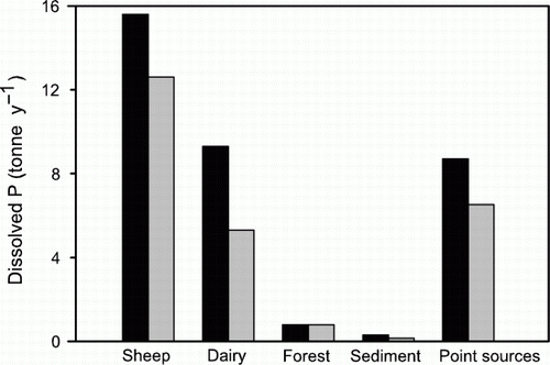
Figure 2 Sources of dissolved P in Manawatu River at Hopelands (black) and Teachers' College (grey).
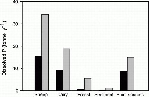
Table 9 Estimate sources of various forms of P at Hopelands per year from 1989–2009.
Table 10 Sources of various forms of P at Teachers' College per year from 1989 to 2009.
Discussion
For the first time in New Zealand we have estimated both the total and dissolved P losses and the likely sources of P for a large catchment, by using the Overseer® nutrient budget and NZeem® models in tandem. The losses as PP were estimated to be 20 times greater than from dissolved P (1500 vs 75 t P yr−1 at Teachers' College). The largest source of soluble P in the Manawatu River is pasture land, and the smallest sources were forests and sediment on the bed of the river. The P concentration of spring waters in forests is about 10 mg P m−3, which equates to soluble P losses of about 0.06 kg ha−1 yr−1 (McGroddy et al. Citation2008). Forest land in the Manawatu also loses 0.6 kg P ha−1 yr−1 by erosion (Dymond et al. Citation2010); this is within the range of 0.2–3 kg P ha−1 yr−1 for P lost by weathering and erosion of soils and rocks in New Zealand (Parfitt et al. Citation2008a). Erosion losses equate to losses of 5.5 kg P ha−1 yr−1 from sheep and beef pasture land, and 2.2 kg P ha−1 yr−1 from dairy pasture land. These losses are generally larger than for overseas catchments (Withers & Jarvie Citation2008) and arise from the soft rock geology, steep slopes, pasture cover and intense storms. The total flux, including sediment, is 493 kg P km−2 yr−1, which is greater than that from the Amazon river (236 kg P km−2 yr−1) and for all Atlantic rivers (Howarth et al. Citation1996), and larger than for the whole Horizons region of 22,200 km (158 kg P km−2 yr−1) estimated by Parfitt et al. (Citation2008a).
Total annual P losses from sheep farms in Manawatu hill country were 0.7–1.5 kg P ha−1 yr−1, and just 15% of this was DRP (Lambert et al. Citation1985). However, later data from Gillingham & Gray (Citation2006) showed that larger losses occurred during some storm events. They found that during 2001 two large storms caused 1.2 kg P ha−1 to move as sediment from land to streams. There were also losses during 15 other smaller events that year, with 0.7 kg P ha−1 yr−1 moving as PP from dung, sheep tracks and other areas of exposed soil. They reported total P losses of 1.8 kg P ha−1 yr−1 where the Olsen-P value was 6, and 4.1 kg P ha−1 yr−1 where the Olsen-P was 26. The DRP concentrations were 0.019 and 0.037 g m−3, DOP values were 0.018 and 0.019 g m−3, and PP were 0.024 and 0.053 g m−3, respectively (Gillingham & Gray Citation2006).
The 0.3 and 1.3 t P released from sediment on the bed of the river is derived from the P extracted with NaOH (Dorich et al. Citation1985). There is considerable uncertainty in these numbers because Dorich et al. (Citation1985) report that about half of the P extracted by NaOH was taken up by algae in 2–14 days. On the other hand, there are about seven flood events each year that expose fresh sediment surfaces in the Manawatu river, so that a single extraction with NaOH may underestimate the P release (Ekholm & Krogerus Citation2003; Jarvie et al. Citation2005). Our estimation does not allow for sorption by sediment, and is only a snapshot for two samplings in 2010. Others have suggested using a bioassay or extraction with dilute CaCl2 to estimate P dissolution from sediment; these methods give a smaller dissolution (Hedley Citation1978; Lucci et al. Citation2010). Therefore, our data probably only give an order of magnitude for the release of P, and this gives a relatively small source of DRP compared with the annual losses from pasture (after attenuation).
Potential mitigation gains in Upper Manawatu Water Management Zones (above Hopelands)
Point sources contribute about 20%–25% to the load of soluble P in the river. A large part of this comes from detergents in effluent and sewage (Stow et al. Citation2001). In recent years, effluent has been treated (with alum) by some townships, effluent ponds are being lined to prevent leakage, and effluent is being applied to land, and this has generally reduced the input to the river, so the P load from these sources is decreasing (Anon. Citation2012). If P-free detergents were used this would considerably reduce the P load in the river. At Hopelands, we estimate point sources will contribute about 6.5 t dissolved P by 2020 compared with 8.7 t P in 2011, a reduction of 25%, as a result of planned mitigation practices ().
Figure 3 Modelled estimates of sources of dissolved P (DRP + DOP) in the Manawatu River at Hopelands in 2010 (black), and loads achievable by 2020 (grey) if recommendations were implemented (t P yr−1). Note: Some of the 511 t of PP remains on the bed of the river and generates a maximum of 0.3 t of dissolved P yr−1.
For dairy farming, gains could be made from changes to management, such as removing cows from streams, banks and channels (McDowell & Wilcock Citation2007), and retaining all milking platform P losses in effluent ponds and improved effluent management. Losses due to cows in streams were about 0.5 kg P ha−1 yr−1 (McDowell & Wilcock Citation2007) and there were 20,300 ha of dairy land at Hopelands, so fencing streams on 10% of the farms gives gains totalling 1 t P. Gains can be made from diverting drainage from tracks that link to streams, and bridging stream crossings. For dairy farms this could reduce the losses by 0.1 kg P ha−1 yr−1. If this applies to half the dairy farms, this could reduce the load in the Manawatu River at Hopelands by 1 t P yr−1.
Shifting from pond discharge, for farm dairy effluent management, to an effective land-based effluent treatment system (that includes ensuring the effluent block is of sufficient size, and sufficient pond storage capacity to hold effluent when soils are wet) offers enormous scope for reducing farm P losses (Houlbrooke et al. Citation2004; Monaghan & Smith Citation2004; Monaghan et al. Citation2008). Gains can be made, therefore, from irrigating farm dairy effluent according to deferred irrigation criteria where applications are made only to soil that has a sufficient soil water deficit to store applied volumes. Furthermore, when soil infiltration limitations exist or preferential flow of applied effluent is likely, further gains can be made using low-rate irrigation technology (Houlbrooke et al. Citation2006). For dairy farms this could reduce the losses by 1 kg P ha−1 yr−1 on at least 10% of the milking platforms. This would reduce the load in the Manawatu River at Hopelands by 2 t P yr−1. The consented effluent loads at Hopelands have already been reduced from a peak of about 3 t DRP yr−1 in 1998 to 0.5 t DRP yr−1 in 2006 (Roygard & McArthur Citation2008).
Gains can be made from using reactive-phosphate-rock (RPR) on pastures with acid soils rather than more soluble P fertilizers (Hart et al. Citation2004), since soluble fertilizers can move short distances to streams (McDowell et al. Citation2010). The gains depend on weather conditions, such as storms occurring shortly after applying fertilizer. Assuming that the loss from soluble P fertilizers during a large storm is an average of 1 kg P ha−1 yr−1 (Gillingham & Gray Citation2006) and from RPR is 0.5 kg P ha−1 yr−1, then the loss over 1000 ha would be 1 and 0.5 t P, respectively. Most fertilizer P, however, is retained in soils by incorporation in organic matter and by reaction with iron and aluminium (Parfitt et al. Citation2008a).
Limiting P fertilizer inputs to maintenance amounts, and keeping levels within FertResearch recommended guidelines, reduces farm P losses (McDowell & Wilcock Citation2007). Monaghan et al. (Citation2007) found targeting fertilizer inputs to maintain Olsen values in the optimum agronomic range offered the greatest saving and a predicted reduction in P losses by 30%–37% in two dairy catchments. The agronomic optimum can be attained through use of Overseer® together with soil test information and production levels for each major land unit on the farm. When too much P fertilizer is used on low anion storage capacity soils, P losses increase exponentially; therefore P fertilizer use here should be reduced. On the other hand, P fertilizer use could increase if farm management intensifies in UMWMZ, leading to increased P losses. We assume these increases and reductions in P loss will cancel each other in the catchment budget, but there is uncertainty in this assumption.
The gains overall from dairy farms could possibly be 4 t dissolved P, and 3 t for sheep and beef farms ().
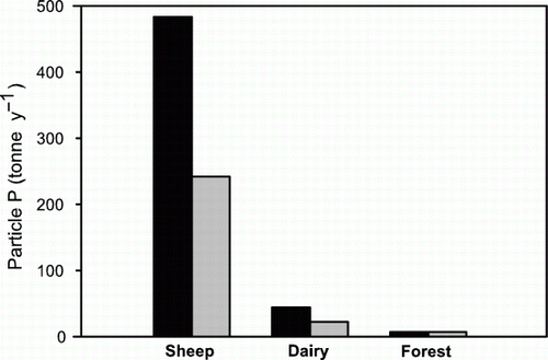
The greatest gains in reducing total export of P from land to rivers at high flows can be made by applying best management practices on erodible land under pasture. Loss of PP at Hopelands is 535 t P yr−1, with 527 t P yr−1 from steeper land on farms. The SLUI whole farm plan could reduce the PP losses from pasture land from 527 to 263 t P yr−1 () with targeted planting of highly erodible land, and by implementing whole farm plans on approximately 10% of farms with the highest areas of highly erodible land (Dymond & Shepherd Citation2006; Schierlitz et al. Citation2006; Ausseil et al. Citation2013). It takes several years after planting for tree roots to bind the soil, so the achievement of these gains will lag behind the implementation of whole farm plans, especially if they are staggered over a number of years (Douglas et al. Citation2008). Targeting the SLUI whole farm plans at the highest priority farms is the best way to achieve gains in the shortest term. By reducing the introduction of fresh sediment into the bed of the Manawatu River there would also be reductions in P released from the river bed.
Figure 4 Modelled estimates of sources of particulate P in Manawatu River at Hopelands in 2010 (black), and loads achievable by 2020 (grey) if recommendations were implemented on all affected land on day 1 (t P yr−1).
The sum of all these gains could reduce the average DRP + DOP (dissolved P) load at Hopelands from 34.6 to 25.4 t P yr−1; similar proportional reductions could be made for the Manawatu catchment above Teachers' College. The ANZECC (Citation2000) recommended guideline for slightly disturbed lowland ecosystems for DRP has been set at 10 mg P m−3. Current concentrations at Hopelands are usually >10 mg P m−3, except when periphyton actively strip DRP in summer. With these mitigation measures it should be possible to reduce current DRP concentrations towards the guideline concentration.
There is uncertainty in our estimates, arising from uncertainties in the Overseer® nutrient budget (Ledgard Citation2009) and NZeem® models (Dymond et al. Citation2010), and there are statistical errors associated with taking the average annual data. The Overseer® model, however, can be used with more certainty to assess changes to management of land (Ledgard Citation2009). With these changes to management of land and WWTP, improvements in water quality are expected to occur, and monitoring of P in the Manawatu River should be carried out on a regular basis to both measure these changes and give more precise numbers.
Conclusions
The total and dissolved P losses and the likely sources of P have been estimated for the Manawatu catchment using a modelling approach. Losses of soluble P come from both point sources and diffuse sources; the order being: sheep and beef farms > dairy farms > point sources >forest > river sediment. Mitigation measures that would improve water quality during times of low flow include reducing losses from point sources, removing animals from stream banks and water ways, and better management of dairy effluent and of P fertilizer inputs. The long-term losses of PP occur mainly during major rainstorms, and give large total P losses from land to rivers. Most of these losses come from sheep and beef pastures on hill country. Decreasing the sediment deposition on the bed of the river will also improve water quality during times of low flow, since less P will be released from the sediment in the river bed, and the habitat for aquatic organisms will also improve.
Acknowledgements
We were grateful to Anne-Gaelle Ausseil (Landcare Research), to the Landcare Research Environmental Chemistry Laboratory and to NIWA for data, and to colleagues at AgResearch, Brent Clothier (Plant and Food), Troy Baisden (GNS) and Deborah Ballantine (NIWA) for guidance. The funding for this project was from the Foundation for Research, Science and Technology through the technology transfer Envirolink programme and from Horizons Regional Council.
References
- AgResearch 2009 . Overseer® nutrient budgets model . www.agresearch.co.nz/overseerweb (accessed 1 March 2010) .
- Anon . 2012 . The Manawatu River Leaders Accord . www.manawaturiver.co.nz/news/spearheading-a-collaborative-approach/ (accessed 19 December 2012) .
- ANZECC 2000 . Australia and New Zealand guidelines for fresh and marine water quality . Canberra, ACT , , Australia , Australia and New Zealand Environment and Conservation Council 1 and 2 .
- Ausseil A-GE , Dymond JR , Kirschbaum MUF , Andrew RM , Parfitt RL 2013 . Assessment of multiple ecosystem services in New Zealand at the catchment scale . Environmental Modelling & Software 43 : 37 – 48 doi: 10.1016/j.envsoft.2013.01.006 .
- Ballantine DJ , Walling DE , Collins AL , Leeks GJL 2009 . The content and storage of phosphorus in fine-grained channel bed sediment in contrasting lowland agricultural catchments in the UK . Geoderma 151 : 141 – 149 . doi: 10.1016/j.geoderma.2009.03.021
- Ballantine DJ , Walling DE , Leeks GJL 2006 . The deposition and storage of sediment-associated phosphorus on the flood plains of two lowland groundwater fed catchments . In : Rowan J , Duck RW , Werrity A . Sediment dynamics and the hydromorphology of fluvial systems . Proceedings of a symposium held in Dundee , UK , July 2006. IAHS Publication 306 , Wallingford , UK . Pp. 496 – 504 .
- Biggs BJF 2000 . New Zealand periphyton guideline . NIWA , Christchurch . June 2000 . www.mfe.govt.nz/publications/water/nz-periphyton-guide-jun00.pdf (accessed 21 November 2012) .
- Clark ME , Roygard JKF 2008 . Landuse and landuse capability in the Manawatu-Wanganui Region: Internal report to support policy development . Report: 2008/INT/616 . Horizons Regional Council , Palmerston North , , New Zealand .
- Clothier B , Mackay A , Carran A , Gray R , Parfitt RL , Francis G 2007 . Farm strategies for contaminant management . A report by SLURI, the Sustainable Land Use Research Initiative, to Horizons Regional Council . AgResearch , New Zealand . www.horizons.govt.nz/assets/horizons/Images/one_plan/Farm%20Strategies%20for%20Contaminant%20Management%20June%202007.pdf (accessed 16 October 2012) .
- Dorich RA , Nelson DW , Sommers LE 1985 . Estimating algal available phosphorus in suspended sediments by chemical extraction . Journal of Environment Quality 14 : 400 – 405 .
- Douglas G , Dymond J , McIvor I 2008 . Monitoring and reporting whole farm plans as a tool for affecting land use change . Envirolink report for Horizons Regional Council , New Zealand . 40 p.
- Dymond JR , Ausseil A-GE , Parfitt RL , Herzig A , McDowell RW 2013 . Nitrate and phosphorus leaching in New Zealand: a national perspective . New Zealand Journal of Agricultural Research 56 : 49 – 59 . doi: 10.1080/00288233.2012.747185
- Dymond JR , Betts HD , Schierlitz CS 2010 . An erosion model for evaluation of regional land-use scenarios . Environmental Modelling and Software 25 : 289 – 298 . doi: 10.1016/j.envsoft.2009.09.011
- Dymond , JR , Shepherd J 2006 . Highly erodible land in the Manawatu/Wanganui region . Landcare Research Contract Report 0607/027 , New Zealand . 10 p.
- Ekholm P , Krogerus K 2003 . Determining algal-available phosphorus of differing origin: routine phosphorus analyses versus algal assays . Hydrobiologia 492 : 29 – 42 . doi: 10.1023/A:1024857626784
- Elliott AH , Alexander RB , Schwartz GE , Shanker U , Sukias JPS , McBride GB 2005 . Estimation of nutrient sources and transport for New Zealand using the hybrid mechanistic-statistical model SPARROW . New Zealand Journal of Hydrology 44 : 1 – 27 .
- Gillingham AG , Gray MH 2006 . Measurement and modelling of runoff and phosphate movement from seasonally dry hill-country pastures . New Zealand Journal of Agricultural Research 49 : 233 – 245 . doi: 10.1080/00288233.2006.9513714
- Hamill K 2008 . Review of water quality standards in the proposed One Plan by Opus International Consultants , prepared for Palmerston North City , New Zealand .
- Hart MR , Quin BF , Nguyen ML 2004 . Phosphorus runoff from agricultural land and direct fertiliser effects: a review . Journal of Environmental Quality 33 : 1954 – 1972 . doi: 10.2134/jeq2004.1954
- Hedley MJ 1978 . Assessment of the biological availability of particulate-phase phosphorus . Unpublished PhD thesis , Massey University , Palmerston North , , New Zealand . 279 .
- Houlbrooke DJ , Horne DJ , Hedley MJ , Hanly JA , Scotter DR , Snow VO 2004 . Minimising surface water pollution resulting from farm dairy effluent application to mole-pipe drained soils. I. An evaluation of the deferred irrigation system for sustainable land treatment in the Manawatu . New Zealand Journal of Agricultural Research 47 : 405 – 415 . doi: 10.1080/00288233.2004.9513609
- Houlbrooke DJ , Monaghan RM , Smith LC , Nicolson C 2006 . Reducing contaminant losses following application of farm dairy effluent to land using a K-line irrigation system . In : Curie LD , Hanly JA Implementing sustainable nutrient management strategies in agriculture . Occasional report No 19 . Fertiliser and Lime Research Centre, Massey University , Palmerston North , , New Zealand . Pp. 290 – 300 .
- Howarth RW , Billen G , Swaney D , Townsend A , Jaworski N , Lajtha K et al. . 1996 . Regional nitrogen budgets and riverine N & P fluxes for the drainages to the North Atlantic ocean: natural and human influences . Biogeochemistry 35 : 75 – 139 . doi: 10.1007/BF02179825
- Jarvie H , Jurgens M , Williams R , Neal C , Davies J , Barrett C et al. 2005 . Role of river bed sediments as sources and sinks of phosphorus across two major eutrophic UK river basins: the Hampshire Avon and Herefordshire Wye . Journal of Hydrology 304 : 51 – 74 . doi: 10.1016/j.jhydrol.2004.10.002
- Lambert CP , Walling DE 1988 . Measurement of channel storage of suspended sediment in a gravel-bed river . Catena 15 : 65 – 80 . doi: 10.1016/0341-8162(88)90017-3
- Lambert MG , Devantier BP , Nes P , Penny PE 1985 . Losses of nitrogen, phosphorus and sediment in runoff from hill country under different fertiliser and grazing management regimes . New Zealand Journal of Agricultural Research 28 : 371 – 379 . doi: 10.1080/00288233.1985.10430441
- Landcare Research 2010 . www.landcareresearch.co.nz/services/laboratories/eclab/eclabtest_list.asp. (accessed March 2010) .
- Ledein E , Ausseil O , Roygard J 2007 . Identifying point source and non-point source contributions to nutrient loadings in waterways in three catchments in the Manawatu-Wanganui Region . Technical report to support policy development . Horizons Regional Council , New Zealand .
- Ledgard SF 2009 . Report of Dr Stewart Francis Ledgard on behalf of Horizons Regional Council concerning water quality . http://www.horizons. govt.nz/assets/horizons/Images/One%20 Plan%20Officers%20reports%20water%20hearing/Dr%20Stewart%20 Francis%20Ledgard.pdf (accessed November 2012) .
- Lucci GM , McDowell RW , Condron LM 2010 . Evaluation of base solutions to determine equilibrium phosphorus concentrations (EPC0) in stream sediments . International Agrophysics 24 : 157 – 163 .
- Mackay A , Clothier B , Parfitt RL 2008 . Defining nitrogen loss limits within a water management zone using the natural capital valuation of the soil . In : Currie LD , Yates LJ Carbon and nutrient management in agriculture . Occasional Report No. 21 . Fertilizer and Lime Research Centre, Massey University , Palmerston North , , New Zealand . 525 – 530 .
- McDowell RW 2006 . Phosphorus and sediment loss in a catchment with winter forage grazing of cropland by dairy cattle . Journal of Environmental Quality 35 : 575 – 583 . doi: 10.2134/jeq2005.0364
- McDowell RW , Larned ST , Houlbrooke DJ 2009 . Nitrogen and phosphorus in New Zealand streams and rivers: control and impact of eutrophication and the influence of land management . New Zealand Journal of Marine and Freshwater Research 43 : 985 – 995 . doi: 10.1080/00288330909510055
- McDowell RW , Littlejohn RP , Blennerhassett JD 2010 . Phosphorus fertilizer affects phosphorus loss to waterways: a paired catchment study . Soil Use and Management 26 : 365 – 373 . doi: 10.1111/j.1475-2743.2010.00289.x
- McDowell RW , Monaghan RM , Wheeler D 2005 . Modelling phosphorus loss from New Zealand pastoral farming systems . New Zealand Journal of Agricultural Research . 48 : 1 – 11 . doi: 10.1080/00288233.2005.9513643
- McDowell RW , Wilcock RJ 2007 . Sources of sediment and phosphorus in stream flow of a highly productive dairy farmed catchment . Journal of Environmental Quality 36 : 540 – 548 . doi: 10.2134/jeq2006.0352
- McDowell RW , Wilcock RJ 2008 . Water quality and the effects of different pastoral animals . New Zealand Veterinary Journal 56 : 289 – 296 . doi: 10.1080/00480169.2008.36849
- McGroddy M E , Baisden WT , Hedin LO 2008 . Stoichiometry of hydrological C, N, and P losses across climate and geology: An environmental matrix approach across New Zealand primary forests . Global Biogeochemical Cycles 22 : GB1026 , doi: 10.1029/2007GB003005
- Monaghan RM , de Klein CAM , Muirhead RW 2008 . Prioritisation of farm scale remediation efforts for reducing contaminant losses to waterways: a case study of New Zealand dairy farming . Journal of Environmental Management 87 : 609 – 622 . doi: 10.1016/j.jenvman.2006.07.017
- Monaghan RM , Hedley MJ , Di HJ , McDowell RW , Cameron KC , Ledgard SF 2007 . Nutrient management in New Zealand pastures: recent developments and future issues . New Zealand Journal of Agricultural Research 50 : 181 – 201 . doi: 10.1080/00288230709510290
- Monaghan RM , Smith LC 2004 . Minimising surface water pollution resulting from farm dairy effluent application to mole-pipe drained soils. II. The contribution of preferential flow of effluent to whole-farm pollutant losses in subsurface drainage from a West Otago dairy farm . New Zealand Journal of Agricultural Research 47 : 417 – 428 .
- Parfitt RL 2006 . Estimates of the loads of dissolved phosphate and nitrate in streams flowing into the Manawatu River between Dannevirke and Hopelands in late spring and early summer 2005 . Landcare Research Report 0506/098 to Horizons Regional Council , New Zealand .
- Parfitt RL , Baisden WT , Elliott AH 2008a . Phosphorus inputs and outputs for New Zealand in 2001 at national and regional scales . Journal of the Royal Society of New Zealand 38 : 37 – 50 .
- Parfitt RL , Dymond J , Mackay A , Gillingham A , Houlbrooke D , McDowell R et al. 2008b . Sources of P in the Manawatu River and implications for the ONE PLAN . In : Currie LD , Yates LJ Carbon and nutrient management in agriculture . Occasional Report No. 21 . Fertilizer and Lime Research Centre, Massey University , Palmerston North , , New Zealand . Pp. 515 – 524 .
- Parfitt RL , Mackay AD , Ross DJ , Budding PJ 2009 . Effects of soil fertility on leaching losses of N, P and C in hill country . New Zealand Journal of Agricultural Research 52 : 69 – 80 .
- Parfitt R , Sutherland A , Wilde H , Dymond J , Ausseil A-G 2004 . GIS risk layers of phosphorus loss from soil to rivers for the Manawatu-Wanganui Region . Landcare Research Contract Report LC0304/139 to Horizons Regional Council , New Zealand . 9 p.
- Roygard J , McArthur K 2008 . A framework for managing non-point source and point source nutrient contributions to water quality . Technical report to support policy development. Horizons Regional Council Report No. 2008/EXT/792 .
- Roygard JKF , McArthur KJ , Clarke ME 2012 . Diffuse contributions dominate over point sources of soluble nutrients in two sub-catchments of the Manawatu River, New Zealand . New Zealand Journal of Marine and Freshwater Research 46 : 219 – 241 .
- Schierlitz C , Dymond J , Shepherd J 2006 . Erosion/sedimentation in the Manawatu catchment associated with scenarios of whole farm plans . Landcare Research Contract Report LC0607/028 to Horizons Regional Council , New Zealand . 10 p.
- Stow CA , Borsuk ME , Stanley DW 2001 . Long-term changes in watershed nutrient inputs and riverine exports in the Neuse River, North Carolina . Water Research 35 : 1489 – 1499 .
- Withers PJA , Jarvie HP 2008 . Delivery and cycling of phosphorus in rivers: A review . Science of the Total Environment 400 : 379 – 395 .