Abstract
An average of 16 years' data at sites in the upper Taireri River catchment was used to determine if water quality had changed commensurate with an increase in the irrigated area and land-use change. To help remediate perceived gaps in the nutrient modelling software Overseer®, data was also collected from a low-intensity border dyke and high-intensity spray-irrigated property. Filterable reactive phosphorus concentrations increased over time and were attributed to the irrigation of poor anion storage capacity (ASC) soils and irrigation-return flows. Differences were noted between measured nitrogen and phosphorus loads and those predicted by Overseer®, which were attributed to a combination of low ASC soils, spray irrigation and artificially drained soils receiving effluent. These data will be used to calibrate future versions of Overseer®. However, with an increase in spray irrigation and land-use change forecast for the catchment, strategies should be employed to mitigate further water quality deterioration.
Introduction
Irrigation of dryland pastures can markedly improve productivity and profitability of grazing systems, but can also exacerbate the loss of surface water quality contaminants such as faecal bacteria, nitrogen (N), phosphorus (P) and sediment (Trout et al. Citation2007). Globally, about two-thirds of water abstracted from ground or surface water resources is used for irrigation (Döll Citation2002). In New Zealand, agriculture accounts for 77% of water allocated for use, with the majority of irrigation used in the provinces of Canterbury (972,000 ha irrigated) and Otago (141,000 ha irrigated) (Aqualinc Citation2006). Methods of irrigation vary, but generally, flood irrigation (usually border dyke or, less often, wild flood) is used on older schemes, whereas newer schemes tend to use the more efficient sprinkler systems such as centre-pivot, low-rate systems and rotary-boom irrigators; they allow a greater area to be irrigated from the same amount of water—c. 90%–94% efficiency compared with 53%–79% for flood irrigation (Causapé et al. ). However, although irrigation application rates are usually well below soil infiltration rates, run-off can occur as sub-surface flow (including leaching) or saturation-excess surface run-off, especially if high application rates are used as an insurance against soil moisture deficits. This run-off can carry with it considerable N, P, suspended solids (SS) and faecal indicator bacteria (Escherichia coli) to receiving streams and also increase flow rates in otherwise dry streams (McDowell et al. Citation2011).
Although better management practices (including those aimed at irrigation) can decrease losses of water quality contaminants, it is inevitable that some will be lost. For instance, in removing soil moisture as a limit to growth, high inputs of fertilizer nutrients are used to ensure maximum potential pasture production. In order to utilize the additional pasture grown, stocking rate is increased. However, the 500–1000 kg N ha−1 deposited in a cow urine patch is well beyond the ability of the pasture to uptake N leading to the potential for the surplus to be lost as nitrate-N in sub-surface flow (Ledgard et al. Citation1999). Enriched soil P concentrations coupled with animal treading, grazing and dung depositions increases the loss of P in surface run-off (McDowell et al. Citation2007). However, in soils with little Al- or Fe-oxides, also measured as anion storage capacity in New Zealand (McDowell & Condron Citation2004), and high infiltration rates, much P loss (e.g. 0.5–2 kg P ha−1 yr−1; McDowell et al. Citation2004) can also occur via sub-surface flow. Artificially increasing soil moisture also has the potential to increase losses of sediment and E. coli via surface run-off by increasing the likelihood that soils are near saturation when a storm event occurs. For sediment, losses are also exacerbated in soils with too little soil carbon to form aggregates and bind them together (Hewitt & Shepherd Citation1997).
The upper Taieri in central Otago has traditionally been farmed with drystock, with rainfall supplemented by two irrigation schemes that together irrigate 9300 ha (ORC Citation2006). A push for increased profitability is seeing the conversion and amalgamation of drystock farms, and the water rights contained therein, to increase the area under irrigation, using no more water, but supporting dairying. Furthermore, while it is possible to make a profit from drystock farming, often profits are boosted by acting as support blocks for recent dairy farm conversions (e.g. wintering or run-off blocks) (MAF Citation2010). With some land-use change, intensification to dairying, and the likelihood for more in the upper Taieri catchment, one of the main objectives of this paper was to determine if there had been a change in surface water quality indicators commensurate with changes in land use since the introduction of the two irrigation schemes.
If an effect of land-use change associated with irrigation is established, methods to assess and mitigate the loss of water quality contaminants from land to water, especially in areas of recent or planned land-use change where there are sparse data, largely rely on the accuracy of models. One of the main models employed in New Zealand to predict the loss of N and P in relation to farm management practices and land use is the Overseer® nutrient budgeting model (AgResearch Citation2013), hereafter called ‘Overseer®’. The output from this model is continuously being updated and calibrated against new experimental data as it comes to hand (AgResearch 2013). Data gaps exist for the calibration of Overseer® and one such gap relevant to the upper Taieri is for Semi Arid soils under irrigation (AgResearch Citation2013). There is also potential that due to the prevalence in the upper Taieri of soils with a high infiltration rate and low anion storage capacity (ASC), the losses of surface water quality contaminants such as P may be high compared with similar intensity pastoral farms on other soil orders with higher ASC. Hence, a second objective was to determine the relative loss of surface water quality contaminants under flood and spray irrigation and compare these with Overseer® estimates.
Materials and methods
Site description and sampling
The upper Taieri catchment spans 183,000 ha in Otago, New Zealand. The Taieri River originates in rolling tussock atop the Lammermoor and Lammerlaw ranges at an altitude of c. 1200 m. From here the headwaters flow northwards, falling 200 m towards Canadian flat. The river then flows via a scroll plain in the Styx Basin through the Paerau Gorge and into the Maniototo Basin, finally out-flowing at Waipiata (). Long-term annual rainfall in the Maniototo Basin (1991–present) is 281 mm (ORC Citation2011).
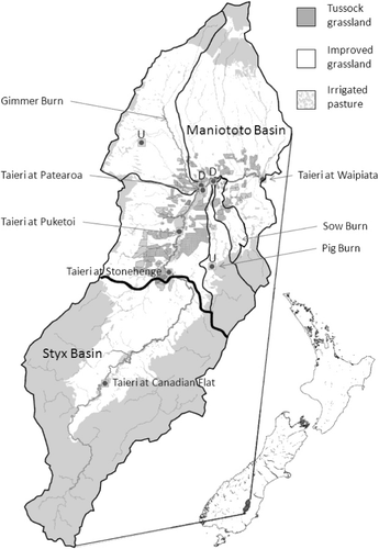
A number of small tributaries flow into the Taieri River, namely the Gimmer Burn (Wether Burn) and Ewe Burn from the north, and Sow Burn and Pig Burn from the south and east. All of these tributaries are heavily abstracted for irrigation, rarely flowing outside of spring and storm events. The exception is the Gimmer Burn, which although dry in the mid-reach, receives regular by-wash (i.e. used and unused irrigation) from the Maniototo irrigation company (MIC) scheme. The irrigation scheme was setup in 1975 to irrigate the west side of the Maniototo Basin, while a scheme was also established to irrigate the eastern side of the basin in 1989. Both schemes take up to 6 m3 s−1 from the main stem of the Taieri River and water stored in the Logan Burn reservoir. In total, the schemes irrigate c. 60 farms and 9300 hectares.
Irrigation is generally supplied via wild flood or border-dyke systems. However, more efficient irrigation systems—largely centre-pivot and low-rate sprinkler systems—have become popular as a method of irrigating more land, intensifying and increasing profit. A side effect of increasing land under irrigation is the potential transport of water quality contaminants via irrigation return flow, which is known to be a particularly important contributor to the Taieri River due to low rainfall (ORC Citation2011). Surface irrigation return flows occur via outwash either directly to the river or via schemes that discharge to the Gimmer Burn and Sow Burn.
Land use (sourced from Agribase data; A sure Quality NZ Citation2010) in the Taieri headwaters is typified by either red tussock (Chionochloa rubra), plantation forestry (largely Pinus radiata) or extensive rangeland farmed with drystock (red deer, sheep and beef) in uplands. At lower elevations, land use is almost exclusively drystock with small irrigated areas used strategically for finishing stock. Most drystock farms employ border-dyke or flood-irrigation systems. Stocking rates tend to be 3–8 stock units (su) ha−1 depending on the proportion of extensive hill country or irrigated land within the property. Over most drystock farms, small amounts of P (10–15 kg ha−1) and sulphur (15–20 kg ha−1) are applied annually and lime (1–4 Mg ha−1) applied every 2–4 years; N is rarely used. In contrast, N is regularly used on dairy farms in the basin (150 kg ha−1), as is P, potassium and S (e.g. 30–40, 80 [via effluent] and 60–80 kg ha−1, respectively). Stocking rates are also higher (3–3.5 cows ha−1 equating to 22–28 su ha−1). The area within the Maniototo Basin under dairying and dairy support (sheep and beef farms used during winter for grazing by dairy cattle) has increased from nothing in 1990 to c. 5000 ha in 2011 (ORC Citation2012) with the change to spray irrigation and also the amalgamation and conversion of drystock farms and water rights.
The main New Zealand soil order within the upper Taieri is Semi Arid with smaller outcrops of Brown and Pallic soil orders in the headwaters. Characteristically, Semi Arid soils have little organic matter (e.g. organic C <20 g kg−1) and poor P retention capacity (anion storage capacity, ASC; <20%), but high infiltration rates due to a coarse texture (e.g. sandy loams).
Water monitoring and analysis
As part of regular assessments made by the Otago Regional Council, flow has been recorded since 1992 via a permanent stage height recorder at three long-term State of the Environment (SOE) sites on the Taieri River (, ) and regular gaugings used to calculate a flow record for sites at Puketoi and Patearoa. Water quality was assessed on grab-samples taken bi-monthly at each site, except for the site at Patearoa which was not sampled between 2007 and 2009. Beginning in September 2010, sites on the Taieri River and on the Sow Burn and upstream and downstream of irrigated land on the Gimmer Burn and Pig Burn were also monitored for flow and grab-sampled fortnightly for 14 months ().
Table 1 Median concentration (all mg L−1 except E. coli which is measured as a MPN cfu 100 mL−1) and load (all kg ha−1 except E. coli which is measured as a MPN cfu ha−1 for the 14-month intensive sampling and period of record) of water quality analytes for sites (1 = farthest upstream) on the main stem of the Taieri River. The P-value for the Mann–Whitney test is given as a test of a significant difference between median concentrations upstream and the immediate downstream site. The relative Sens Slope Estimator (RSKSE) is given to indicate a significant (P < 0.05) annual percentage change (>1%) in the median concentration over the period of record.
Grab samples of stream water were filtered (<0.45 µm) in the field and kept on ice while being transported to a commercial lab for analysis within 24 h. Samples were analysed for nitrate plus nitrite N (NNN) (±1 mg m−3); ammoniacal-N (NH4-N) (±1 mg m−3); total N (TN) (±10 mg m−3); filterable reactive P (FRP) (±1 mg m−3), total P (TP) (±1 mg m−3), SS (±2 mg m−3) and E. coli using standard protocols and methods (APHA Citation1998; Wilcock et al. Citation2006).
Non-parametric statistics were used to compare the central tendency (median) of water quality analytes between sites. For SOE sites, trend analysis was conducted with Time Trends v3.0 (Jowett Citation2009) via Seasonal Kendall tests on raw and flow-adjusted data (LOWESS smoothing, 30% span; Hirsch & Slack Citation1984). The Relative Seasonal Kendall Sen Slope Estimator (RSKSE) was calculated as the Kendall Sens Slope Estimator for flow adjusted data divided by the raw median values, and was used to represent the magnitude (significant if P < 0.05 and RSKSE >1%) and direction of trends in data. Annual loads were calculated via interpolation (see method 5; Johnes Citation2007) of fortnightly (and bi-monthly) samples for the 2010–11 year (September to October) and for the period of record for the Taieri River sites. While it should be noted that this method may underestimate loads for contaminants such as TP which are dominated by stormflow (Johnes Citation2007), the recommended weekly sampling could not be achieved due to cost.
Monitored farms
To act as potential calibration sites for Overseer®, two farms representative of border dyke and spray irrigation were monitored. Both were on a slowly permeable, gleyed variant of a Drybread shallow-to-stony fine sandy loam soil (Typic Aged-argillic Semi Arid soil: New Zealand Soil Classification; Hewitt Citation1998). The first was a drystock property supporting 8 su ha−1 distributed over 2500 ha with 115 ha in border-dyke irrigation (including 15 ha in wild flood) for finishing stock. Any outwash from the border and wild-flood irrigated area was captured and routed into a storage system designed to supplement inflow intended for spray irrigation on other parts of the farm. Irrigation water was supplied on a rotational basis (when available) from the MIC to the farm. The area monitored was usually the first to receive irrigation on the farm. Irrigation occurred if the farm owner deemed there was a sufficient soil water deficit to realize a benefit. From September 2010 to May 2011, irrigation (c. 135 mm per application) occurred seven times. The area was grazed approximately every 25–30 days at 18 su ha−1 with cattle and sheep. Nutrient inputs consisted of 18 kg P ha−1 and 26 kg of S ha−1 applied in late spring.
Monitoring involved measuring water depths and taking samples of water at a 0.5 m wide weir located at the inlet and outlet of three border strips. Each strip was about 100 m long and bounded by earthen borders 20 m apart and with wooden boards at the downslope end angled at 130° to direct flow towards the outlet weir. Most of the irrigations were 90 min long with two lasting for 120 min. Flow measurements were used to create a hydrograph of the event and generate a single flow-proportional sample of water at the inlet and outlet that was later analysed for FRP, TP, SS and E. coli. Loads were calculated as the product of flow-weighted outflow (minus inflow) concentration and total outwash (at the outlet). Six soil samples were taken of the 0–7.5 cm depth from each strip, bulked, dried, crushed and sieved (<2 mm) and analysed for Olsen P, organic C, ASC and water extractable P (a measure of potential P loss to run-off; McDowell & Condron Citation2004).
The second farm was a recently established dairy farm, supporting 3.5 cows ha−1 spread over 255 ha, with 143 ha spray-irrigated via a centre pivot and the remainder utilizing a low-rate system. For the centre pivot, irrigation was supplied every 24–48 h resulting in an average application depth of 6–8 mm day−1. Irrigation water contained effluent sourced from a third (in-line) effluent settling pond mixed with irrigation water at a ratio of 1:10 effluent to irrigation water. Nutrients, including those in effluent, were applied at a rate of 150 kg N ha−1 and 50 kg P ha−1 annually. Due to the slowly permeable nature of the site and a water table about 2 m below the soil surface, a permanently flowing drain installed at about 1.5 m below the soil surface spanned the length of the centre pivot-irrigated area whose flow was augmented by three artificial drainage channels installed at 70–90 cm depth beneath the area irrigated by the centre pivot. Water-level recorders were placed in the main drain upstream and downstream of the centre pivot-irrigated area and weekly samples taken (plus flow proportional samples taken during flood events) at both locations from September 2010 to November 2011. The analytes and methods used to establish loads were the same as those used for the stream and river monitoring programme. Annual loads were expressed as a proportion of the artificially drained area under centre-pivot irrigation. A meteorological station was located on site measuring rainfall, soil moisture at 20, 40 and 60 cm depth and calculating potential evapotranspiration.
Measured loads of N and P for each monitor farm were compared against those predicted using the nutrient budgeting software—Overseer® v.6.0 (AgResearch Citation2013). Data for the two farms were generated from detailed interviews incorporating the information outlined above.
Results and discussion
Water quality state and trend
Median concentrations of most water quality analytes at SOE sites on the Taieri River were within guidelines for good surface water quality in lowland streams in New Zealand (0.009, 0.033, 0.444, 0.9 and 0.614 mg L−1 for FRP, TP, NNN, NH4-N and TN, respectively; ANZECC Citation2000). The exception was for FRP and TP concentrations at all sites within the Maniototo Basin ().
Trend analysis at each site used on average 16 years' worth of data and showed that a meaningful trend (>1% change in annual median concentrations; relative Sens Slope—RSKE, ) occurred for NNN, P fractions and SS, but seldom for E. coli (log-transformed), NH4-N or total N. For NNN, there was a general decrease in the Styx Basin, while a decrease was also evident for SS at sites downstream in the Maniototo Basin. Despite having a strong association between P and SS, and a decrease in median SS concentrations (McDowell et al. Citation2008), TP exhibited no change whereas FRP increased from site-to-site in the Maniototo Basin.
Using a non-parametric Mann–Whitney test, median concentrations of SS were only enriched between Puketoi and the last site at Waipiata, commensurate with the greatest area of irrigated land (). Median concentrations of NNN exhibited increases, decreases or no differences between upstream and downstream sites. For FRP and TP there was a consistent increase in median concentrations between upstream and downstream sites throughout the Taieri River. On average, the concentrations of FRP and TP increased from 0.003 to 0.0017 mg L−1 (560%) and from 0.014 to 0.050 mg L−1 (350%), respectively, from the headwaters of the Styx Basin to the outlet of the Maniototo Basin.
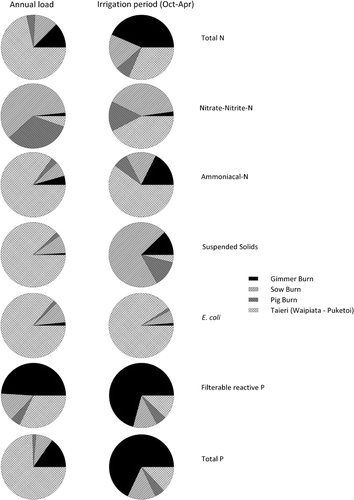
Examination of the tributaries (Gimmer Burn, Pig Burn and Sow Burn) flowing into the Taieri River between Puketoi and Waipiata showed that where they joined the Taieri River, loads of TN, FRP and TP were greater than the area-specific load at either main stem site ( and ). These tributaries drain a significant proportion of the irrigated land downstream of Puketoi (25349, 5391 and 9616 ha for the Gimmer Burn, Pig Burn and Sow Burn, respectively).
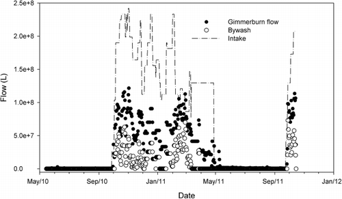
Largely due to irrigation takes, sections of each tributary (downstream of headwater sites) are dry for much of the year. Flow in dry sections occurs beneath the surface of the stream bed, flowing again where significant volumes of irrigation-return flow arise or during storm events (ORC Citation2011). This return flow can be via sub-surface or surface flows (e.g. surface run-off), but for the Gimmer Burn is also in the form of by-wash (used and unused irrigation water) from the MIC irrigation race. At the outlet of the Gimmer Burn, flow rarely occurred outside of the irrigation season (). By-wash was 29% of flow, meaning the remaining 71% was via irrigation-return flow. As a proportion of the irrigation take, flow at the outlet of the Gimmer Burn (including by-wash and irrigation-return flow) was 39% meaning the remaining 61% was used and lost via evapotranspiration, evaporation or irrigation-return flow prior to reaching the Gimmer Burn ().
Irrigation-return flow can carry with it significant quantities of mobile nitrate that has leached from irrigated and grazed pasture (McDowell et al. Citation2011), and depending on the hydrological pathway and soil type, can also carry E. coli, P and sediment. A comparison of upstream and downstream sites either side of irrigated land in the Gimmer Burn and Pig Burn indicated significant enrichment of N and P fractions at the downstream site (). Losses of P, E. coli and sediment to water are usually dominated by surface run-off (McDowell et al. Citation2008). However, significant enrichment only occurred between the Pig Burn sites. For sub-surface flow, losses of P and E. coli can be important where artificial drainage, macropores and/or limited attenuation (e.g. sorption) occur within the soil (Smith et al. Citation1985; Toor et al. Citation2005). However, McLeod et al. (2008) classified the immature soils in the basin as having a low likelihood of microbial bypass flow due to their lack of macropores. Where macropore flow in the soil is low, the potential for P loss in sub-surface flow is then related to the quotient of Olsen P and anion storage capacity (ASC, formerly known as P retention; McDowell & Condron Citation2004). Given that the soil in the Maniototo is of low ASC (commonly 10%–15%), this suggests that sub-surface transport of P could be much greater than soils of a higher ASC.
Table 2 Median concentration (all mg L−1 except E. coli which is measured as a MPN cfu 100 mL−1) and load (all kg ha−1 except E. coli which is measured as a MPN cfu ha−1 for the 14-month intensive sampling) of water quality analytes for upstream (top) and downstream (bottom) sites (where present) contributing to flow in the lower section of the Taieri River. The P-value for the Mann–Whitney test is given as a test of a significant difference between median concentrations upstream and downstream sites.
The influence of irrigation is evident when comparing the relative loadings of each of the tributaries to the receiving segment of the Taieri River (Waipiata minus Puketoi). For most of the analytes, the tributaries accounted for <25% of the annual load. However, when only the irrigation season was examined, most of the estimated load for all analytes except E. coli came from the tributaries (), especially for P fractions, which is consistent with past studies of the enrichment and loss of P from irrigated land (e.g. McDowell et al. Citation2011).
Losses from flood-irrigated system
Flood-irrigation systems, like border dykes, are an inefficient user of water compared with spray irrigation systems (Heermann & Solomon Citation2007). This inefficiency has been recorded in New Zealand and Australian studies to yield significant quantities of outwash (30%–60%: Austin et al. Citation1996; Wilcock et al. Citation2011). Much of this is due to a mismatch between soil specific infiltration rates, soil moisture and irrigation rates (i.e. time that headrace gates are open) (McDowell & Houlbrooke Citation2009). Over the seven events that delivered irrigation of 950 mm during the 2010/11 irrigation season, mean outwash was 53%.
Much data exist to show that outwash is a significant source of E. coli and P loss (e.g. Carey et al. Citation2004): sediment losses tend to be small due to good pasture cover preventing erosion (Wilcock et al. Citation2011). Median concentrations of E. coli and P fractions were enriched in outwash compared with ANZECC (Citation2000) guidelines (). For E. coli, this translated into a load that was an order of magnitude greater than that seen in the Taieri River or its tributaries (, and ). Despite having a low ASC (), and hence high potential for P loss, the mean measured loss was c. 0.9 kg TP ha−1. Losses were compared against other studies of outwash under drystock and dairy as flow-weighted means to account for different outwash volumes. A Mann–Whitney test indicated that the median (of mean) FRP (P < 0.001) and TP (P = 0.002) concentrations were enriched under dairy (3.0 mg FRP L−1 and 3.5 mg TP L−1) compared with drystock (0.252 mg FRP L−1 and 0.386 mg TP L−1), while the median (of mean) loss of FRP and TP from the Maniototo border-dyke site was no different from the median (of mean) loss of FRP and TP from other drystock studies in Australia and New Zealand ().
Table 3 Median concentration (all mg L−1 except E. coli which is measured as a MPN cfu 100 mL−1) and load (all kg ha−1 except E. coli, which is measured as a MPN cfu ha−1) of water quality analytes in outwash sampled from the border-dyke irrigated farm between September 2010 and May 2011.
Table 4 Mean (+ standard error) values of soil chemical constituents in top soil (0–7.5 cm) of the border-dyke and spray-irrigated sites.
Table 5 Mean concentration and load of P fractions in outwash, P fertilizer applied and irrigation applied in studies of border-dyke irrigation in Australia and New Zealand.
However, losses of P in the studies in and ours do not capture sub-surface losses. Under flood irrigation, much P loss can occur in sub-surface flow (Sinaj et al. Citation2002). At the border-dyke site, depth sampling of soil every 7.5 cm indicated that ASC was low in the topsoil (12%, ) and on average remained below 12% to 45 cm. Mean Olsen P concentration only decreased from an average of 17 in the 0–7.5 cm depth () to 12 at the 37.5–45 cm depth. Using the equations of McDowell & Condron (Citation2004) that predict the likelihood of surface and sub-surface flow from measures like Olsen P and ASC, this translates into a P concentration in the soil solution of 0.056 mg L−1. Provided the soil solution did not meet an outcrop of higher ASC soil, this suggests that there is potential for enrichment should flow reach the Taieri River or one of its tributaries.
While sub-surface flow was not sampled in the present study, research in Canterbury, New Zealand suggests that the losses of N as nitrate under flood irrigation are similar to that under spray irrigation (Di et al. Citation1998).
Losses from spray-irrigated site
At our spray-irrigated site, the load of N lost was dominated by nitrate (), but considered low for a dairy farm (Ledgard et al. Citation1999). Although the waterway received flow from drains located directly beneath the spray-irrigated site, high soil moisture via irrigation and a shallow water table would have promoted gaseous N losses via denitrification (Stenger et al. Citation2008). Furthermore, in establishing a pasture sward and intensifying when moving from drystock to dairying on a low organic C soil, it is likely that much of the N will be immobilized in the root zone as soil organic matter increases (Walker et al. Citation1959; McLaughlin et al. Citation2006 ) or in shoot material due to the rapid uptake of N by new pasture (Scholefield et al. Citation1993). Work in Southland, New Zealand found that changing from drystock to intensively grazed dairy cattle yielded high N immobilization rates of 142 and 121 kg N ha−1 yr−1 in plots receiving 200 and 400 kg N ha−1 yr−1 (Monaghan et al. Citation2005). However, Percival et al. (Citation2003) hypothesized that immobilization is not indefinite and, as such, losses would start to increase with time.
Table 6 Median concentration (all mg L−1 except E. coli which is measured as a MPN cfu 100 mL−1) and load (all kg ha−1 except E. coli, which is measured as a MPN cfu ha−1) of water quality analytes sampled from the spray-irrigated farm between September 2010 and November 2011.
The load of P lost from the spray-irrigated site was large, indeed much larger than most other studies of intensive dairying in New Zealand (McDowell & Wilcock Citation2008). Hydrologically, a water balance showed that after removing potential evapotranspiration of 779 mm, irrigation (1016 mm at c. 6 mm per day) and rainfall (574 mm) yielded streamflow of 811 mm. This indicates that there is some scope in decreasing irrigation and therefore sub-surface flow and streamflow. The enhanced P loss could be due to a number of factors. The first is the increased frequency of high soil moisture via irrigation leading to sub-surface flow and streamflow. High soil moisture may have resulted in reducing conditions and mobilization of P via the dissolution of P sorbed to Fe-oxides (Sallade & Sims Citation1997). The second is the aforementioned low ASC of the soil, which combined with a moderate Olsen P () would result in an enriched soil solution P and potential for loss (e.g. water extractable P=0.066 mg L−1, ). A third is the presence of an artificial drainage network to facilitate losses from the soil solution to the stream channel. Finally, poor structural stability from low organic C concentration of the soil (; Hewitt & Shepherd Citation1997) will enhance the dispersion of bed sediments in the stream channel and the decomposition of artificial drainage (viz. mole) channels resulting in P losses in particulate form (TP minus filterable unreactive P and FRP).
The load of E. coli lost under spray irrigation was similar to that in tributaries of the Taieri River (), but less than that lost from the border-dyke irrigated area. This reflects the fact that the majority of flow under the spray-irrigated site was via sub-surface, and probably matrix flow that tends to filter out E. coli (Smith et al. Citation1985; McLeod et al. Citation2008).
Prediction of losses at the farm scale
Management of the potential impact of irrigation on receiving waters requires knowledge of how much of each contaminant is being lost and of effective strategies to minimize the loss. One of the most widely used models to assess the loss of N and P from pastoral farms in New Zealand is the use of Overseer® (AgResearch Citation2013). Although widely calibrated, data are not available to cover all possible combinations of, for example, land management, climate and soil types. Overseer® files were generated for both of the monitor farms. The load of N predicted to be lost from the spray-irrigated farm was 41 kg N ha−1 yr−1, about twice that measured in the stream. However, Overseer® predicts the loss from the root zone and therefore may not be directly comparable with streamflow losses without consideration of processes such as immobilization in the soil and denitrification that decrease losses en route. For P, losses were estimated to be 2.8 and 1.2 kg P ha−1 yr−1 from the spray- and border-dyke irrigated farms, respectively: a difference of about 0.3 kg P ha−1 yr−1 was overestimated for the border-dyke farm and 1.8 kg P ha−1 yr−1 underestimated for the spray-irrigated farm. The data suggest that modelling P losses from the spray-irrigated farm require further examination. For low ASC soils (receiving irrigation or high rainfall), modelling with Overseer® has been successful in other parts of New Zealand (e.g. McDowell & Houlbrooke Citation2009; McDowell Citation2010). However, the combination of effluent in irrigation water (which is known to exacerbate P leaching; Toor et al. 2005), low ASC soils and an artificial drainage network (acting as macropores to quickly route drainage water and P to the stream channel) has not been observed. Data from the Maniototo spray-irrigated site will be used to calibrate future versions of the model.
Management considerations in the upper Taieri
With the shift towards spray irrigation and intensification in the Maniototo Basin, data suggest that water quality is responding and that strategies should be used before detrimental ecosystem effects occur. Losses of SS have decreased over time. Hence, it is more likely that detrimental effects will include the impairment of aesthetic values or recreational values (e.g. by periphyton or faecal bacteria). Periphyton growth is likely to be N-limited (N:P ratio < 7; McDowell et al. Citation2008). This is likely to be reinforced by extensive macrophyte growth in the Styx Basin stripping N from the water column, and the potential for immobilization and high denitrification rates (via irrigation of slowly permeable soils) that combine to decrease N losses at a basin scale (e.g. Vale et al. Citation2007; Brown et al. Citation2011). However, while immobilization of N in the soil is high following conversion to dairy from drystock (Monaghan et al. Citation2005), this is likely to decrease over time (Percival et al. Citation2003) and may increase N losses to the Taieri River as pastures mature. Much work in Canterbury has shown intensification of dairying over the past 20 years has resulted in ‘N-leaky’ systems that are now impacting on groundwater (Haywood & Hanson Citation2004). Hence, in order to prevent losses in the future or allow for headroom for the expansion of current operations, it would be wise to employ systems and mitigation strategies to minimize the loss of N from the root zone.
For border-dyke systems, a number of strategies are available to mitigate the loss of contaminants such as: not over-grazing before irrigation to minimize sediment or particulate bound P loss; the use of a low water soluble P fertilizer to minimize fertilizer P available for loss in outwash (McDowell et al. Citation2003); and preventing outwash and the transport of contaminants derived from the soil surface (e.g. P, sediment and E. coli) by better matching irrigation to soil water deficits or blocking outlets to streams (Houlbrooke Citation2007). For spray-irrigation systems, infiltration rates can decrease due to soil consolidation (Lehrsch & Kincaid Citation2010), but more so with animal traffic, which if not carefully managed can promote surface contaminant transfers. However, sub-surface flows are usually the main pathway of contaminant loss to waterways. Hence, the principal mitigation mechanism would be to prevent sub-surface flow by better matching spray-irrigation rates with spatial changes in soil type and moisture on a daily basis (e.g. Delgado & Bausch Citation2005; Hedley et al. Citation2010). Measures may also be taken to decrease the source of N available for loss via nitrification inhibitors or the modification of applications rates and contaminant concentrations (e.g. P and E. coli) in effluent (Brennan et al. Citation2011).
Summary and conclusions
An investigation of water quality contaminants at sites along the Taieri River and tributaries within the upper Taieri catchment indicated that median concentrations of most contaminants were generally low relative to recommended guidelines except for P fractions. Trend analysis at long-term SOE sites indicated that most contaminants exhibited little or no trend except for an increase in FRP and decrease in SS in the Maniototo Basin. The enrichment of FRP occurred from site-to-site towards the outlet of the Maniototo Basin, while the majority of the load was from tributaries during the irrigation season. Transport of contaminants was most likely via irrigation-return flows via a combination of outwash, by-wash, but most likely sub-surface flows. The low ASC of soils in the basin were highlighted as a key potential cause of P loss.
Data were collected from a border-dyke and a spray-irrigated farm. Losses of P, SS and E. coli in outwash were no different from other studies of border-dyke systems. In contrast, losses of P from the spray-irrigated farm were high compared with other farm-scale losses under dairying and attributed to a combination of low ASC soils, artificial drainage and effluent application. Modelling with Overseer® was able to predict P losses to within 0.3 kg P ha−1 yr−1 from the border-dyke irrigated site, but overestimated N losses and underestimated P losses at the spray-irrigated site. These data will be used to calibrate future versions of Overseer®.
Water quality data is showing signs of response to irrigation. Hence, it is recommended that with the forecast expansion for dairying in the upper Taieri that the adoption of mitigation practices would be beneficial in preventing water quality deterioration.
Acknowledgements
This work was supported by the New Zealand Ministry for Business, Innovation and Employment's contract (C10X1006, Clean Water, Productive Land) and the Otago Regional Council. The co-operation of local farmers and the MIC in data acquisition and access is greatly appreciated. In particular we would like to acknowledge AgResearch and ORC staff involved in the implementation and acquisition of data: Belinda Glass, Natasha Styles, Matt Hickey, Simon Cullen, Steve Smith and Ali MacArthur. was drawn by Andrew MacKay.
References
- AgResearch 2013. Overseer® Nutrient Budgets v6.0: References and technical notes. Available at: http://www.overseer.org.nz/OVERSEERModel/Information/References.aspx (accessed April 2013).
- ANZECC (Australian and New Zealand Environment and Conservation Council) 2000. Australian and New Zealand guidelines for fresh and marine water quality. Canberra, ACT, Australian and New Zealand Environment and Conservation Council—Agriculture and Resource Management Council of Australia and New Zealand.
- APHA (American Public Health Association) 1998. Standard methods for the examination of water and wastewater. 20th edition. Washington DC, USA, American Public Health Association, American Water Works Association and Water Environment Federation.
- Aqualinc 2006. Snapshot of water allocation in New Zealand. Report no. ME782. Wellington, New Zealand, Ministry of the Environment. http://www.mfe.govt.nz/publications/ser/snapshot-water-allocation-nov06/index.html (accessed April 2013)
- AsureQuality NZ 2010. Agribase. Database of NZ farms. August 2009 version, www.asurequality.com/geospatial-services/agribase.cfm (accessed April 2013)
- Austin NR, Prendergast JB, Collins MD 1996. Phosphorus losses in irrigation runoff from fertilized pasture. Journal of Environmental Quality 25: 63–68. 10.2134/jeq1996.00472425002500010008x
- Barlow K, Nash D, Grayson RB 2005. Phosphorus export at the paddock, farm-section, and whole farm scale on an irrigated dairy farm in south-eastern Australia. Australian Journal of Agricultural Research 56: 1–9. 10.1071/AR04166
- Brennan RB, Fenton O, Grant J, Healy MG 2011. Impact of chemical amendment of dairy cattle slurry on phosphorus, suspended sediment and metal loss to runoff from a grassland soil. Science of the Total Environment 409: 5111–5118. 10.1016/j.scitotenv.2011.08.016
- Brown JB, Sprague LA, Dupree JA 2011. Nutrient sources and transport in the Missouri River basin with emphasis on the effects of irrigation and reservoirs. Journal of the American Water Resources Association 47: 1034–1060. 10.1111/j.1752-1688.2011.00584.x
- Carey PL, Drewry JJ, Muirhead RW, Monaghan RM 2004. Potential for nutrient and faecal bacteria losses from a dairy pasture under border-dyke irrigation: a case study. Proceedings of the New Zealand Grassland Association 66: 141–149.
- Causapé FXM, Derby N, Knighton RE, Steele DD, Stegman EC 2006. Irrigation efficiency and quality of irrigation returns flows in the Ebro River Basin: an overview. Environmental Monitoring and Assessment 117: 451–461.
- Close ME, Woods PH 1986. Leaching losses from irrigated pasture: Waiau Irrigation Scheme, North Canterbury. New Zealand Journal of Agricultural Research 29: 339–349. 10.1080/00288233.1986.10426990
- Delgado JA, Bausch WC 2005. Potential use of precision conservation techniques to reduce nitrate leaching in irrigated crops. Journal of Soil and Water Conservation 60: 379–387.
- Di HJ, Cameron KC, Moore S, Smith NP 1998. Nitrate leaching and pasture yields following the application of dairy shed effluent or ammonium fertilizer under spray or flood irrigation: result of a lysimeter study. Soil Use and Management 14: 209–214. 10.1111/j.1475-2743.1998.tb00152.x
- Döll P 2002. Impact of climate change and variability on irrigation requirements: global perspective. Climate Change 54: 269–293. 10.1023/A:1016124032231
- Haywood SA, Hanson CR 2004. Nitrate contamination of groundwater in the Ashburton-Rakaia plains. Report no. R04/9. Christchurch, New Zealand, Environment Canterbury.
- Hedley C, Yule I, Bradbury S 2010. Analysis of potential benefits of precision irrigation for variable soils at five pastoral and arable production sites in New Zealand. 19th World Congress of Soil Science, Brisbane, QLD, Australia. http://www.iuss.org/19th%20WCSS/Symposium/pdf/1104.pdf (accessed September 2012).
- Heermann DF, Solomon KH 2007. Efficiency and uniformity. In: Hoffman GJ, Evans RG, Jensen ME, Martin DL, Elliot RL eds. Design and operation of farm irrigation systems 2nd edition. St Joseph, MI, USA, American Society of Agricultural and Biological Engineers. Pp. 108–119.
- Hewitt AE 1998. New Zealand soil classification. Landcare Research Science Series 1: 1–133.
- Hewitt AE, Shepherd TG 1997. Structural vulnerability of New Zealand soils. Australian Journal of Soil Research 35: 461–474. 10.1071/S96074
- Hirsch RM, Slack JR 1984. A nonparametric trend test for seasonal data with serial dependence. Water Resources Research 20: 727–732. 10.1029/WR020i006p00727
- Houlbrooke DJ 2007. Evaluation of wipe-off management practices on border dyke irrigated land in the Pahau catchment. Prepared for Environment Canterbury, AgResearch-Invermay Agricultural Centre, Mosgiel, New Zealand.
- Johnes PJ 2007. Uncertainties in annual Riverine phosphorus load estimation: Impact of load estimation methodology, sampling frequency, baseflow index and catchment population density. Journal of Hydrology 332: 241–258. 10.1016/j.jhydrol.2006.07.006
- Jowett I 2009. Time Trends Software v3.0. National Institute of Water and Atmospheric Research, Hamilton, New Zealand. http://www.niwa.co.nz/__data/assets/file/0004/99553/TimeTrends3.0.zip (accessed April 2013)
- Ledgard SF, Penno JW, Sprosen MS 1999. Nitrogen inputs and losses from clover/grass pastures grazed by dairy cows, as affected by nitrogen fertilizer application. Journal of Agricultural Science 132: 215–225. 10.1017/S002185969800625X
- Lehrsch GA, Kincaid DC 2010. Sprinkler irrigation effects on infiltration and near-surface unsaturated hydraulic conductivity. Transactions of the American Society of Agricultural and Biological Engineers 53: 397–404.
- MAF (Ministry of Agriculture and Forestry) 2010. Livestock Statistics, Ministry of Agriculture and Forestry, Wellington, New Zealand. http://www.maf.govt.nz/statistics/pastoral/livestock-numbers/ (accessed April 2013)
- McDowell RW 2010. Evaluation of two management options to improve the water quality of Lake Brunner, New Zealand. New Zealand Journal of Agricultural Research. 53: 59–69. 10.1080/00288231003606351
- McDowell RW, Biggs BJF, Sharpley AN, Nguyen L 2004. Connecting phosphorus loss from land to surface water quality. Chemistry and Ecology (London) 20: 1–40. 10.1080/02757540310001626092
- McDowell RW, Condron LM 2004. Estimating phosphorus loss from New Zealand grassland soils. New Zealand Journal of Agricultural Research 47: 137–145. 10.1080/00288233.2004.9513581
- McDowell RW, Houlbrooke DJ 2009. Management options to decrease phosphorus and sediment losses from irrigated cropland grazed by cattle and sheep. Soil Use and Management 25: 224–233. 10.1111/j.1475-2743.2009.00231.x
- McDowell RW, Houlbrooke DJ, Muirhead RW, Müeller K, Shepherd M, Cuttle SP 2008. Grazed pastures and surface water quality. Hauppage, New York, Nova Science Publishers. 238 p.
- McDowell RW, Monaghan RM, Carey PL 2003. Potential phosphorus losses in overland flow from pastoral soils receiving long-term applications of either superphosphate or reactive phosphate rock. New Zealand Journal of Agricultural Research 46: 329–337. 10.1080/00288233.2003.9513561
- McDowell RW, Nash DM, Robertson F 2007. Sources of phosphorus lost from a grazed pasture soil receiving simulated rainfall. Journal of Environmental Quality 36: 1281–1288. 10.2134/jeq2006.0347
- McDowell RW, Rowley D 2008. The fate of phosphorus under contrasting border-check irrigation regimes. Australian Journal of Soil Research 46: 309–314. 10.1071/SR07192
- McDowell RW, van der Weerden TJ, Campbell J 2011. Nutrient losses associated with irrigation, intensification and management of land use: a study of large scale irrigation in North Otago, New Zealand. Agricultural Water Management 98: 877–885. 10.1016/j.agwat.2010.12.014
- McDowell RW, Wilcock RJ 2008. Water quality and the effects of different pastoral animals. New Zealand Journal of Veterinary Research 50: 289–296. 10.1080/00480169.2008.36849
- McLauchlin KA, Hobbie SE, Post WM 2006. Conversion from agriculture to grassland builds soil organic matter on decadal timescales. Ecological Applications 16:143–153. 10.1890/04-1650
- McLeod M, Aislabie J, Ryburn J, McGill A 2008. Regionalizing potential for microbial bypass flow through New Zealand soils. Journal of Environmental Quality 37: 1959–1967. 10.2134/jeq2007.0572
- Monaghan RM, Paton RJ, Smith LC, Drewry JJ, Littlejohn RP 2005. The impacts of nitrogen fertilization and increased stocking rate on pasture yield, soil physical condition and nutrient losses in drainage from a cattle-grazed pasture. New Zealand Journal of Agricultural Research 48: 227–240. 10.1080/00288233.2005.9513652
- Mundy GN, Nexhip KJ, Austin NR, Collins MD 2003. The influence of cutting and grazing on phosphorus and nitrogen in irrigation runoff from perennial pasture. Australian Journal of Soil Research 41: 675–685. 10.1071/SR02087
- Nexhip KJ, Mundy GN, Collins MD, Austin NR 1997. Development of nutrient water quality targets for irrigated pasture sub-catchments. Final report Project I5037. Tatura, Victoria, Australia, Institute of Sustainable Irrigated Agriculture. 143 p.
- ORC (Otago Regional Council) 2006. The effect of irrigation runoff on water quality. Dunedin, New Zealand, Otago Regional Council. 47 p.
- ORC (Otago Regional Council) 2011. Water resources of the Taieri catchment: an overview of the 2009/2010 irrigation season. Dunedin, New Zealand, Otago Regional Council. 36 p.
- ORC (Otago Regional Council) 2012. Dairy shed inspections and consents. Dunedin, New Zealand, Otago Regional Council.
- Percival HJ, Schipper LA, Sparling GP 2003. An approach for estimating maximum nitrogen storage in soils at national scales. In: Currie LD, Hanly JA eds. Tools for nutrient and pollutant management. Massey University, New Zealand. Occasional Report 17: 219–223.
- Sallade YE, Sims JT 1997. Phosphorus transformations in the sediment of Delaware's agricultural drainageways: II. Effect of reducing conditions on phosphorus release. Journal of Environmental Quality 26: 1579–1588. 10.2134/jeq1997.00472425002600060018x
- Scholefield D, Tyson KC, Garwood EA, Armstrong AC, Hawkins J, Stone AC 1993. Nitrate leaching from grazed grassland lysimeters: effects of fertilizer input, field drainage, age of sward and patterns of weather. Journal of Soil Science 44: 601–613. 10.1111/j.1365-2389.1993.tb02325.x
- Sinaj S, Stamm C, Toor GS, Condron LM, Hendry T, Di HJ et al. 2002. Phosphorus exchangeability and leaching losses from two grassland soils. Journal of Environmental Quality 31: 319–330. 10.2134/jeq2002.0319
- Smith MS, Thomas GW, White RE, Ritonga D 1985. Transport of Escherichia coli through intact and disturbed soil columns. Journal of Environmental Quality 14: 87–91. 10.2134/jeq1985.00472425001400010017x
- Stenger R, Barkle G, Burgess C, Wall A, Clague J 2008. Low nitrate contamination of shallow groundwater in spite of intensive dairying: the effect of reducing conditions in the vadose zone–aquifer continuum. Journal of Hydrology (NZ) 47: 1–24.
- Toor GS, Condron LM, Cade-Menun BJ, Di HJ, Cameron KC 2005. Preferential phosphorus leaching from an irrigated grassland soil. European Journal of Soil Science 56: 155–167. 10.1111/j.1365-2389.2004.00656.x
- Trout TJ, Steele DD, Eggleston KO 2007. Environmental considerations. In: Hoffman GJ, Evans RG, Jensen ME, Martin DL, Elliot RL eds. Design and operation of farm irrigation systems 2nd edition. St Joseph, MI, USA, American Society of Agricultural and Biological Engineers. Pp. 77–107.
- Vale M, Mary B, Justes E 2007. Irrigation practices may affect denitrification more than nitrogen mineralization in warm climatic conditions. Biology and Fertility of Soil 43: 641–651. 10.1007/s00374-006-0143-0
- Walker TW, Thapa BK, Adams AFR 1959. Studies on soil organic matter: 3 accumulation of carbon, nitrogen, sulphur, organic and total phosphorus in improved grassland soils. Soil Science 87: 135–140. 10.1097/00010694-195903000-00003
- Wilcock RJ, Monaghan RM, Quinn JM, Campbell AM, Duncan MJ, McGowan AW et al. 2006. Land use impacts and water quality targets in the intensive dairying catchment of the Toenepi stream, New Zealand. New Zealand Journal of Marine and Freshwater Research 40: 123–140. 10.1080/00288330.2006.9517407
- Wilcock RJ, Nash D, Schmidt J, Larned ST, Rivers MR, Feehan R 2011. Inputs of nutrients and fecal bacteria to freshwaters from irrigated agriculture: case studies in Australia and New Zealand. Environmental Management 48: 198–211.