
ABSTRACT
Drought reduces pasture production. Irrigation can be an effective response in such situations, but if we apply too little water, production will be less than in the well-watered potential. If we apply too much, nutrients can be leached, reducing soil fertility and causing environmental concern. To evaluate uniformity of water application, we developed a graphical method to analyse measurements along linear transects. By plotting the data, variable results were readily identified as well as potentially systematic patterns. The plot was divided into quadrants and the observations in each quadrant counted. For a random spatial distribution, one-quarter were expected in each quadrant. The observed and expected counts were compared using a Chi square statistical test. To illustrate, we analysed measurements from eleven irrigated farms and data representing contrasting hypothetical situations. The results were informative and appropriately responsive. Using a picture to classify and count the data can be an intuitive, practical method to evaluate an irrigator’s performance
Introduction
An estimated 720,000 ha of New Zealand’s land has been irrigated, 75% of which for pastoral agriculture (IrrigationNZ Citation2015). The pastures were irrigated because drought reduced dry matter production (Scotter et al. Citation1979; McAneney et al. Citation1982; Sumanasena et al. Citation2011). While irrigating pastures can be an effective response to drought, applying too little water results in production that will be less than the well-watered potential (Horne et al. Citation2011). Moreover, by applying water too quickly, soils may not be well watered due to preferential (bypass) flow down cracks and large pores (Cichota et al. Citation2016). By applying too much water, nutrients can be leached (Boy-Roura et al. Citation2016) and pasture production will be less than the well-watered potential (Moir et al. Citation2000). Thus, some water and expenditure for its application would have been wasted. Provided that soils are uniform, by applying the right amount of water at the right time, water use, expenditure and pasture production could be optimised (McAneney & Judd Citation1983). This should matter most if the amount of water available for irrigation becomes restricted which seems most likely in dry years when irrigation will be most needed (Horne et al. Citation2011).
Irrigation systems have generally been designed to apply water uniformly across an irrigated area. This should be the most suitable for an area with uniform soils. Alternatively, a variable rate irrigation system can be adjusted to apply water at different rates across the irrigated area according to user instructions. Thus, a variable rate irrigation system should better accommodate soils which are spatially variable, provided that this information can be quantified at suitable spatial resolution.
The performance of irrigators can be evaluated and if needed, opportunities identified for improvement. Measurements can be made by setting buckets along a linear transect to collect water as an irrigator passes over them. The measurements generate data that will need to be analysed. For the past 60 years, the usual method employed has been to calculate the water application distribution uniformity (DU, Burt et al. Citation1997). For such analysis, the data are sorted from the smallest to largest. A mean is calculated for the data from the lowest quartile (25%) as well as an overall mean. The lowest quartile mean divided by the overall mean is denoted DUlq. In New Zealand, it has been recommended that DUlq should be at least 0.80 (http://irrigationnz.co.nz/wp-content/uploads/2014/03/2013-INZ-Design-Standard.pdf). By this approach and others such as Christiansen’s uniformity coefficient, water application uniformity (variability) is evaluated by a number. A single number cannot represent the variability equally in all situations, especially complex ones such as variable rate irrigation, which may explain why such numbers have been interpreted without statistical tests (Burt et al. Citation1997). In our view, this seemed unsatisfactory.
Recognising the intuitive and straightforward nature of visual assessment, we developed a new graphical method to evaluate an irrigator’s performance according to water application uniformity. For a method to be useful, it should be practical and appropriately responsive. As described, data can be collected by on-farm measurements. The data can be plotted on a graph with water application along the vertical (Y) axis and location along the horizontal (X) axis (). By drawing a horizontal line on the graph set by the mean water application, uniformity can be readily assessed, looking for deviants (outliers) and their locations as well as potentially systematic patterns. Such information can be useful to guide inspection of the irrigator for possible faults. For further evaluation, the horizontal axis can be divided into two sectors by a vertical line. The graph has now been divided into quadrants and the observed number of measurements in each quadrant can be counted. For a random spatial distribution, one-quarter of the measurements will be expected in each quadrant which assumes a symmetric distribution of the random variation in water application. The observed and expected counts can be compared using a Chi-square statistical test. To illustrate the graphical method, we analysed water application measurements from 11 irrigated farms and data representing contrasting hypothetical situations. For the irrigator on one farm, control valves allowed two methods of water application, including a constant rate (‘blanket’ application) and at different rates determined by an irrigation prescription map (‘variable rate’ application). The results and those from DUlq calculations will be discussed.
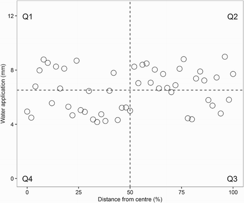
Figure 1. A hypothetical relationship between water application (mm) and distance from the centre (m) of a centre-pivot irrigator passing over a linear measurement transect. The data were randomly spread around a mean which set the horizontal dashed line, while the vertical dashed line represents the middle of the measurement locations. As shown, the dashed lines formed quadrants (Q1–Q4).
Materials and methods
Irrigation water application was measured on 11 farms using buckets with an (inside) diameter of 250 mm and a depth or height of 250 mm. Each bucket was placed upright into another bucket through which a peg had been vertically driven 100 mm into the ground. While all the farms studied were located in the Canterbury region and had flat land, by this arrangement, each bucket could be securely made level by eye. It can be shown that a levelling error <10° corresponds with the bucket ‘catching’ less water than when level, but the error will be <2%. By eye, we found levelling errors >10° were easily detected and corrected.
On six farms with centre-pivot irrigation systems, the buckets were placed along a linear transect at 10–20 m intervals. The irrigators were 350–820 m long with 22–67 buckets per transect. On one farm with a 460-m-long irrigator, there were 11 transects at different locations.
On four farms with lateral-travelling irrigation systems, buckets were placed at 5–16 m intervals along transects. The irrigators were 80–384 m long with 16–23 buckets per transect. On one farm, control valves allowed application at a constant rate (‘blanket’ application) and at rates determined by an irrigation prescription map (‘variable rate’ application).
One farm had a ‘rotorainer’ irrigation system, a rotating horizontal pipe with a spray gun at each end. There were 21 buckets placed at 3 m intervals along a linear transect with an 8 m gap in the middle. Thus, buckets were not located along the system’s ‘non-irrigating’ rotary structure and wheels.
For each transect or sample, the mean water application was calculated as well as the 95% confidence interval (95% CI). As indicated, the method for data analysis began with a graph. Water application was plotted along the vertical (Y) axis and location along the horizontal (X) axis. For the centre-pivot irrigation systems, location was distance from the centre. For the lateral-travelling and rotorainer irrigation systems, location was distance from the edge. Quadrants were formed with a horizontal line located by the mean water application and a vertical line located by the transect midpoint.
Each water application measurement was classified according to its location in a quadrant. As shown in , the upper left-hand quadrant (Q) was designated Q1 with the others in clockwise order, so Q2 to the right, Q3 diagonally opposite and Q4 downwards. Thus, the measurements in Q1 were greater than the mean and located within the innermost half of the transect. In Q2, the measurements were greater than the mean and located within the outermost half. In Q3, the measurements were less than the mean and located within the outermost half. In Q4, the measurements were less than the mean and located within the innermost half. The number of measurements in each quadrant was counted, excluding any which bisected the horizontal and vertical lines.
For each quadrant, the observed number of measurements was compared to one-quarter of the measurements, the expected value representing a random spatial distribution. Each sample’s Chi-square was calculated by a sum of the quadrant calculations of (observed–expected)2 /expected. For the quadrants, there were two rows and two columns, so one degree of freedom and the critical Chi-square value for a one-tailed test was 3.84 (P < .05 for statistical significance). When a sample’s Chi-square exceeded 3.84, the sample was estimated to be significantly different from a random spatial distribution.
As stated, DUlq was calculated for each transect or sample. In addition, four hypothetical datasets were created to examine the water application uniformity of a centre-pivot irrigator in contrasting situations which had the same DUlq. Four more datasets were created to examine contrasting, hypothetical situations for which DUlq ranged from 0.4 to 0.8.
Results and discussion
Using the graphical method to evaluate irrigation systems on farms
To illustrate the graphical method, we analysed water application measurements from 11 irrigated farms. On farm 1, water application was measured at 67 locations over 660 m along a centre-pivot irrigator, the largest sample and longest transect studied (). By plotting the data, only three deviants (1.7, 8.6 and 11.7 mm) were apparent with the water application more than two standard deviations from the mean (5.1 mm, (a)). This information can be used to guide inspection of the irrigation system for possible faults. While approximately half the sample (57%) was less than the mean, these data were mostly located in Q4 (34%). Overall, by quadrants, the sample was estimated to be significantly different from a random spatial distribution. The DUlq was 0.76, also indicating some locations had been under-watered. As stated, the DUlq calculation included the lowest 25% of the sample and by increasing the percentage to 50% to include all data less than the mean, the calculated result increased from 0.76 to 0.86. Consequently, for this sample, DUlq was interpreted to have exaggerated the level of under-watering. Moreover, as a number, DUlq did not indicate that 88% of data for the calculation represented locations in Q4, within the innermost half, and 12% in Q3.
Figure 2. Relationships between water application (mm) and distance from the centre (m) of a centre-pivot irrigator passing over the linear measurement transect on farms 1 (a), 2 (b) and 5 (c). The horizontal dashed line was set by the mean water application, while the vertical dashed line represents the middle of the measurement locations. As shown, the dashed lines formed quadrants. The statistics are given in .
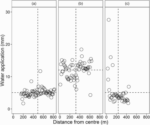
Table 1. Irrigation statistics for centre-pivot systems on six farms as the irrigator passed over a linear transect of buckets (95% CI is the 95% confidence interval and n the number of buckets).
For a centre-pivot irrigator, the irrigated area will be a product of π and the square of distance from the centre. Accordingly, while the distance from the centre to the end of the irrigator will be twice the distance to the middle, the irrigated area from the middle to the end will be three times that from the centre to the middle. Consequently, on an area basis, the further the distance from the centre pivot the more important will be the water application variability. On farm 1, the data in Q4 comprised 34% of the counts and indicated that 23% of the total irrigated area had a mean water application less the overall mean by 0.4 mm or 8%. Moreover, the data in Q2 comprised 28% of the counts and indicated that 37% of the total irrigated area had a mean water application greater than the overall mean by 1.0 mm or 20%. Thus, using the graphical method, the locations which were over-watered and under-watered were identified and assessed.
On farm 2, for measurements made at 63 locations over 620 m, the overall mean (12.0 mm) was more than twice that on farm 1 ((b)). On farm 2, there were again three deviants (4.3, 6.1 and 18.4 mm) and 62% of this sample was greater than the mean including 40% in Q2. The sample was significantly different from a random spatial distribution. The data in Q2 indicated that 60% of the total irrigated area had a mean water application greater than the overall mean by 1.6 mm or 13%. The DUlq was 0.71 with 75% of data for the calculation representing locations in Q4. While Q4 contained 30% of the data and this quadrant’s mean water application was less than the overall mean by 3.4 mm or 28%, these data represented only 15% of the total irrigated area.
In contrast to the data from farms 1 and 2, farm 3 had a smaller sample (21 locations along a 400-m-long transect) which was much more variable (14.6 ± 3.8 mm, overall mean ±95% CI, ). There was only one deviant (37.5 mm) and while 57% of the data were less than the mean, the sample was not significantly different from a random spatial distribution. The quadrant data contained further information. For example, Q4 contained 38% of the data, the mean water application was 6.4 mm or 44% less than the overall mean and these data represented 26% of the total irrigated area (individual data not shown). Moreover, Q2 contained 29% of the data, this quadrant’s mean water application was 12.9 mm or 12% less than the overall mean and these data represented 41% of the total irrigated area. A DUlq of 0.40 for farm 3 was the minimum for this study. Four of the five data points for this calculation represented locations in Q4. Consequently, for this sample, DUlq mostly represented an extreme subset of the Q4 results and by itself, potentially misleading because the Q2 results were more important.
Another example of contrasting results came from farm 5 where the measurements were made at 43 locations over 400 m ((c)). There were two deviants (16.0 and 27.6 mm) from the mean (5.1 mm), the 95% CI was ±27% of the mean and water application was less than the mean at 84% of the locations. The sample was significantly different from a random spatial distribution. While the data in Q1 indicated that the mean water application was 8.0 mm or 176% greater than the overall mean, these data represented only 4% of the total irrigated area. The data in Q3 indicated that 67% of the total irrigated area had a mean water application which was 1.8 mm or 35% less than the overall mean. Moreover, the data in Q4 indicated that a further 25% of the total irrigated area had a mean water application which was 1.4 mm or 27% less than the overall mean. The DUlq was 0.48, including seven data points from Q3 and three from Q4. Thus, for farm 5, the data used to calculate DUlq were representative and the result was less extreme than that for farm 3.
To examine the effects of wind and transect location on the graphical method, we analysed 11 sets of measurements made in 7 paddocks on farm 4. For each 420-m-long transect along a centre-pivot irrigator, water application was measured at 43 locations. For one set when the mean wind speed was 13 m s−1 or three times the long-term mean, the quadrant results were anomalous. For the other sets, the quadrant results were not significantly affected by transect location, angle between transect and the wind from 0° to 84° and wind speed up to 9 m s−1 (data not shown). These quadrant results were also not significantly affected by eliminating every other measurement location (bucket) which halved the size of the sample and increased the bucket spacing from 10 to 20 m (data not shown).
The graphical method was also used to evaluate different types of irrigators for water application uniformity. For example, on farm 7, there were 2 sets of water application measurements at 23 locations over 352 m along a lateral-travelling irrigator (). For the first set, the control valves were adjusted to deliver the same level of water application along the irrigator (‘blanket’ application). For the second set, the valves were controlled by the data in an irrigation prescription map and the amount of water application varied along the irrigator (‘variable rate’ application). For the first set, there was only one deviant (12.6 mm) from the mean (9.7 mm), the 95% CI was ±6% of the mean and water application was greater than the mean at 57% of the locations. This set was significantly different from a random spatial distribution. The DUlq was 0.84 and all data for the calculation represented locations in Q3 (data not shown). For Q3, including 39% of the total data, the mean water application was 1.6 mm or 16% less than the overall mean. As before when DUlq was greater than 0.80, the data used to calculate DUlq for this set were representative and a similar level of under-watering was indicated by the Q3 calculations.
Table 2. Irrigation statistics for laterally travelling and rotating (rotorainer) systems on five farms as the irrigator passed over a linear transect of buckets (95% CI is the 95% confidence interval and n the number of buckets).
For the second set of measurements on farm 7, there was again only one deviant (8.4 mm) from the mean (12.5 mm) which had increased by 2.8 mm (29%). The 95% CI was ±5% of the mean and water application exceeded the mean at 48% of the locations. The second set was not significantly different from a random spatial distribution. The DUlq was 0.86 and 67% of data for the calculation represented locations in Q4 (data not shown). For Q4, including 35% of the total data, the mean water application was 2.2 mm or 17% less than the overall mean. Thus, the data used to calculate DUlq for the second set were also representative and a similar level of under-watering was indicated by the Q4 calculations. For the graphical method, the level of under-watering can be determined by the Q3 and/or Q4 results. Moreover, as indicated, water application was greater than the overall mean at about half the locations. For farm 7, the ‘variable rate’ results were considerably different from the ‘blanket application rate’ results. Evidently, soils in this irrigated area were spatially variable because the ‘variable rate’ instructions had come from an irrigation prescription map.
Another example of contrasting results for lateral-travelling irrigators came from farms 9 and 10 where the measurements were made at 19 locations over 105 m and 16 locations over 75 m, respectively. For farm 9, there were no deviants, the 95% CI was ±14% of the mean (36.6 mm), 47% of the measurements were greater than the mean and the sample was not significantly different from a random spatial distribution ((a) and ). The DUlq was 0.61 and 40% of data for this calculation represented locations in Q3 and 60% in Q4. For Q3, including 21% of the total data, the mean water application was 10.8 mm or 29% less than the overall mean. For Q4, including 32% of the total data, the mean water application was 11.5 mm or 31% less than the overall mean. For this sample, DUlq was considerably less than 0.80 and represented under-watering more strongly than the larger subsets represented by the Q3 and Q4 results.
Figure 3. Relationships between water application (mm) and distance from the edge (m) of a laterally travelling irrigator passing over a linear measurement transect on (a) farm 9 and (b) farm 10. The horizontal dashed lines were set by the means, while the vertical dashed lines represented the middle of the measurement locations. As shown, the dashed lines formed quadrants. The statistics are given in .
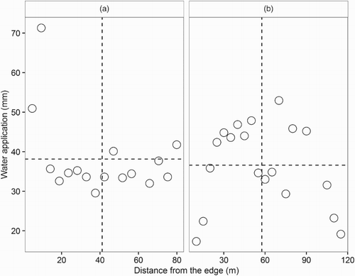
For farm 10, there was one deviant (71.3 mm), the 95% CI was ±14% of the mean (38.1 mm), 76% of the measurements were less than the mean and the sample was significantly different from a random spatial distribution ((b) and ). The DUlq was 0.84 and half the data for this calculation represented locations in Q3 and half in Q4. For Q3, including 38% of the total data, the mean water application was 4.0 mm or 10% less than the overall mean. For Q4, including 38% of the total data, the mean water application was 4.6 mm or 12% less than the overall mean. For this sample, DUlq was greater than 0.80, the data used for the calculation was mostly representative and the indicated level of under-watering was similar to the Q3 and Q4 results.
From the on-farm results, as stated, the quadrant results were not affected by reducing the sample size to about 20 measurements (buckets). For samples of this size and ‘ideal’ operation of an irrigator, water application measurements should have an approximately normal (symmetric) frequency distribution centred on the (overall) mean according to the central limit theorem. In this situation, the data can be statistically analysed and subjected to a Chi-square or other such tests. Alternatively, if an irrigator was not operating ideally, the data’s frequency distribution could be different. As shown, by plotting the data, the distribution can be inspected and deviants and systematic patterns identified. For DUlq, the lower quartile mean includes only 25% of the sample and these data would be skewed. Consequently, unless an irrigator was evaluated by 80+ measurements, DUlq seems unlikely to have a normal frequency distribution. To further examine the DUlq calculation and graphical method, eight hypothetical situations will be analysed in the next section.
Hypothetical situations to further examine the graphical method and DUlq
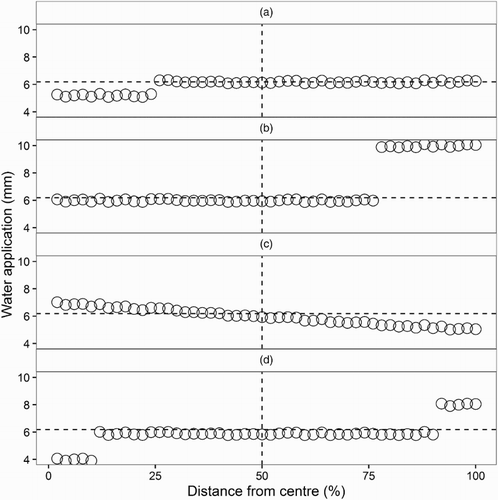
The water application uniformity of a centre-pivot irrigator was examined in four increasingly complex hypothetical situations which had the same DUlq of 0.87. Alternatively, by plotting these data, each situation (set) was seen to be different. For the first set, the data in the lowest quartile had the same (lower by 0.8 mm) value and the remaining data were also invariant ((a)). In contrast, the second set’s data in the largest quartile had the same (higher by 3.0 mm) value and the remaining data were invariant ((b)). Alternatively, the third set’s data had a negative, linear trend (reducing by as much as 4.0 mm like a loss of pressure along the irrigator, (c)). Finally, the fourth set was invariant except for the first five smaller and last five larger values which differed by 4.0 mm from one another and by 2.0 mm from the remaining data ((d)).
Figure 4. Four hypothetical relationships between water application (mm) and distance from the centre (%) of a centre-pivot irrigator passing over a linear measurement transect. Each of the four datasets shown in panels (a)–(d) had the same water application DU (=0.87), calculated as the lowest quartile mean divided by the overall mean (DUlq). The horizontal dashed line was set by the mean water application, while the vertical dashed line represents the middle of the measurement locations. As shown, the dashed lines formed quadrants.
The graphical method was then used to evaluate the water application uniformity of a centre-pivot irrigator in four more contrasting, hypothetical situations. By plotting a set of data randomly spread around a positive linear trend, a systematic pattern was readily apparent with 74% of the data located in Q2 and Q4 ((a)). Statistically, there was one deviant (0.9 mm) from the mean (7.0 mm), the 95% CI was ±12% of the mean and the sample was significantly different from a random spatial distribution (). The DUlq was only 0.43 and all data for the calculation represented locations in Q4. For Q4, including 35% of the data, the mean water application was 3.9 mm or 44% less than the overall mean. For the graphical method, Q2 included 39% of the data and the mean water application was 9.4 mm or 35% greater than the overall mean.
Figure 5. Four hypothetical relationships between water application (mm) and distance from the centre (%) of a centre-pivot irrigator passing over a linear measurement transect. The horizontal dashed line was set by the mean water application, while the vertical dashed line represents the middle of the measurement locations. As shown, the dashed lines formed quadrants. In panel (a), the data were randomly spread around a linear trend. In panel (b), the data were randomly spread around a mean. In panel (c), the data were randomly spread around a curve with its maximum in the middle of the measurement locations. In panel (d), the data’s spread around a mean was skewed. The statistics are given in .
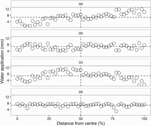
Table 3. Water application statistics for four hypothetical situations whose data are given in .
By plotting a set of data randomly spread around a mean, a pattern seemed apparent and 69% of the data were located in Q2 and Q4 ((b)). There were no deviants, the 95% CI was ±6% of the mean and the sample was significantly different from a random spatial distribution. The DUlq was 0.69 and 75% of data (nine data points) for the calculation represented locations in Q4. For Q4, including 33% of the total data, the mean water application was 5.0 mm or 23% less than the overall mean. While from the previous situation to this one, DUlq increased markedly and the Q4 mean was closer to the overall mean, these calculations indicated different levels of under-watering for locations representing the innermost half. Moreover, the graphical method included Q2 with 36% of the data whose mean water application was 7.7 mm or 18% greater than the overall mean.
By plotting a set of data randomly spread around a curve with its maximum in the middle of the measurement locations, while there seemed to be a pattern ((c)), the sample was not significantly different from a random spatial distribution. There were two deviants (0.9 and 1.1 mm) from the mean (7.0 mm) and the 95% CI was ±10% of the mean. The DUlq was 0.49 and 83% of data for the calculation represented locations in Q4. For Q4, including 22% of the total data, the mean water application was 4.8 mm or 31% less than the overall mean. By changing the situation again, DUlq decreased markedly and the Q4 mean was further from the overall mean, but the calculations indicated different changes in the level of under-watering. In addition, for 53% of the data in Q1 and Q2, the mean water application was 9.0 mm or 29% greater than the overall mean.
By plotting a set of data spread around a mean with a skewed frequency distribution, the variability can be seen ((d)). The 95% CI was only ±4% of the mean (6.8 mm) and there was one extreme deviant (2.9 mm) as well as 18 others ranging from 7.4 to 7.7 mm. While 62% of the data were greater than the mean, the sample was not significantly different from a random spatial distribution. The DUlq was 0.81, a maximum for these four hypothetical situations. Unlike the other situations, 46% of data for this calculation represented locations in Q3 and 54% in Q4. For Q3, including 20% of the total data, the mean water application was 5.8 mm or 15% less than the overall mean. For Q4, including 18% of the total data, the mean water application was 6.0 mm or 12% less than the overall mean. Thus, for this set, the data used to calculate DUlq were representative and similar levels of under-watering were indicated by the Q3 and Q4 results. In addition, for 64% of the data in Q1 and Q2, the mean water application was 7.4 mm or 9% greater than the overall mean.
Conclusions
While irrigation systems have generally been designed to apply water uniformly across an irrigated area, this has been shown to not always be true. On-farm performance should be evaluated which may identify opportunities for improvement. For variable rate irrigation systems, water application should match the user’s instruction and spatial variability of the soils. Water application can be measured along linear transects and by plotting the data, variable results are readily identified as well as potentially systematic patterns. This information can be used to guide the inspection of irrigation systems for possible faults. The data can also be analysed. For this study, the quadrant results interpreted by the Chi-square statistical test were shown to be more representative and appropriately responsive than the lowest quartile DU calculation. Graphical representation of water application data based on frequency is visual and intuitive, plus it includes all of the data collected to evaluate an irrigator’s performance.
Acknowledgements
We are grateful to the farmers who gave us permission to work on their properties. We thank Rogerio Cichota, Colin Gray and Richard Muirhead for helpful comments and Trish Fraser, Val Snow and Steve Thomas for valuable discussions. Constructive criticism on the draft manuscript was provided by three anonymous reviewers.
Disclosure statement
No potential conflict of interest was reported by the authors.
Additional information
Funding
References
- Boy-Roura M, Cameron KC, Di HJ. 2016. Identification of nitrate loss indicators through regression methods based on a meta-analysis of lysimeter studies. Environmental Science and Pollution Research. 23:3671–3680. doi: 10.1007/s11356-015-5529-9
- Burt C, Clemmens A, Strelkoff T, Solomon K, Bliesner RD, Hardy L, Howell T, Eisenhauer D. 1997. Irrigation performance measures: efficiency and uniformity. Journal of Irrigation and Drainage Engineering. 123:423–442. doi: 10.1061/(ASCE)0733-9437(1997)123:6(423)
- Cichota R, Kelliher FM, Thomas SM, Clemens G, Fraser PM, Carrick S. 2016. Effects of irrigation intensity on preferential solute transport in a stony soil. New Zealand Journal of Agricultural Research. 59:141–155. doi: 10.1080/00288233.2016.1155631
- Horne DJ, Sumanasena HA, Scotter DR. 2011. Effects of irrigation frequency on ryegrass and white clover growth. 2. Improving irrigation frequency. Soil Research. 49:361–366. doi: 10.1071/SR10218
- Irrigation NZ. 2015. New Zealand irrigation industry snapshot, 20 p.
- McAneney KJ, Judd MJ. 1983. Pasture production and water use in the central Waikato. New Zealand Journal of Agricultural Research. 26:1–13. doi: 10.1080/00288233.1983.10420945
- McAneney KJ, Judd MJ, Weeda WC. 1982. Loss in monthly pasture production resulting from dryland conditions in the Waikato. New Zealand Journal of Agricultural Research. 25:151–156. doi: 10.1080/00288233.1982.10420904
- Moir JL, Scotter DR, Hedley MJ, Mackay AD. 2000. A climate-drive, soil fertility dependent pasture production model. New Zealand Journal of Agricultural Research. 43:491–500. doi: 10.1080/00288233.2000.9513445
- Scotter DR, Clothier BE, Turner MA. 1979. The soil water balance in a Fragiaqualf and its effect on pasture growth in central New Zealand. Australian Journal of Soil Research. 17:455–465. doi: 10.1071/SR9790455
- Sumanasena HA, Horne DJ, Kemp PD, Scotter DR. 2011. Effects of irrigation frequency on ryegrass and white clover growth. 1. Experimental results. Soil Research. 49:355–360. doi: 10.1071/SR10217