Abstract
New Zealand fiords frequently feature a buoyant low-salinity layer (LSL) leading to unique biological communities on their rock walls. The LSL has previously been distinguished by its temperature, but we show this is not always reliable. We describe temporal and spatial patterns in water temperature in Doubtful Sound, and the influences of rainfall, wind, air temperature and the discharge from the Manapōuri hydroelectric power scheme. Surface (0.5 to 19 m depth) temperatures in the fiords varied considerably at frequencies corresponding with season and weather. Distinct weather events coincided with fluctuations in surface temperatures of 5 °C to 10 °C, a magnitude of temperature change comparable to seasonal variability. Variability of surface water temperatures declined with proximity to the hydroelectric discharge. Statistical analyses indicated that changes in climate and weather are likely to have a larger effect on temperatures than changes in the rate of freshwater discharge.
Introduction
Life-sustaining processes (from molecular to system levels) are ultimately dependent on temperature. In the marine environment, temperature constrains the chemical and physical characteristics of seawater (e.g. diffusivity, viscosity, density; Mann & Lazier Citation1991; Vogel Citation1994) and influences numerous biological processes, including organism metabolism (e.g. Braby & Somero Citation2006), growth rates (e.g. Green & Fisher Citation2004; Lee et al. Citation2007), and spawning (e.g. Minchen Citation1987). Spatial gradients and temporal fluctuations in water temperature also influence organism distributions (e.g. Cairns et al. Citation2008), larval development and dispersal (e.g. O'Connor et al. Citation2007; Whalan et al. Citation2008), and geographic ranges of fish and marine mammals (e.g. Kaschner et al. Citation2006; MacLeod Citation2009). Ocean temperatures vary primarily as a function of solar radiation inputs that change with depth, latitude and season. Water temperatures in estuaries and along coasts can be further influenced by local factors, including natural freshwater inflows from rivers (MacKenzie & Adamson Citation2004) and anthropogenic discharges that result in thermal pollution (Choi et al. Citation2002; Keser et al. Citation2005).
In New Zealand fiords, near-surface water temperatures can be strongly influenced by the frequent presence of low-salinity layers (LSLs) that lie buoyant over the underlying seawater (Stanton & Pickard 1981; Gibbs et al. 2000). Our current understanding of the dynamics of LSLs is largely based on research conducted in Doubtful Sound that has understandably focused on salinity as the defining physical variable of LSLs (Gibbs et al. Citation2000; Gibbs Citation2001). This research has demonstrated that the LSL in Doubtful Sound is an integrated response to rain and wind as well as the continuous discharge of freshwater from Lake Manapōuri into Deep Cove through the tailrace of the Manapōuri hydroelectric power scheme (Gibbs et al. Citation2000; Gibbs Citation2001).
Gradients in salinity associated with LSL have been identified as a primary driver of biological processes in the fiords, including the unique distribution of organisms along the steep rock walls (Witman & Grange Citation1998; Smith Citation2001; Kregting & Gibbs Citation2006). Maintenance of low-salinity water near the surface due to the tailrace discharge has also been linked to shifts in organism distribution and community composition within the intertidal zone along the rock walls (Boyle et al. Citation2001) and within shallow (<4 m depth) sediments at the head of Doubtful Sound (Tallis et al. Citation2004; Rutger & Wing Citation2006; McLeod & Wing Citation2008). In addition to salinity, gradients in water temperature associated with the LSL have the potential to influence biological processes in Doubtful Sound. However, published information on water temperatures in the fiords remains limited to studies that did not capture finer temporal and spatial variation in water temperature associated with LSL dynamics (Stanton & Pickard Citation1981; Stanton Citation1986; Greig et al. Citation1988; Gibbs Citation2001). Perhaps as a result, links between patterns in water temperature and biological aspects of the fiords have not been further explored or identified.
Our study is intended to describe, for the first time, patterns in near-surface water temperatures at a fiord-wide scale in Doubtful Sound and, for comparative purposes, at a location in inner Milford Sound, which is removed from the influence of the tailrace discharge. We utilise continuous datasets of water temperature, meteorological variables and tailrace discharge collected over a five-year period (2005–2010) to: (1) describe temporal and spatial patterns in near-surface (0 to 19 m depth) water temperatures in Doubtful Sound; and (2) explore the role of both natural variables (rain, wind, air temperature) and the tailrace discharge in driving the observed patterns. Results are interpreted in relation to changing tailrace discharge regimes and the potential biological implications of ongoing effects of the discharge on water temperatures. Near-surface water temperatures are known to fluctuate in response to changes in the LSL; however, unlike salinity, temperatures of freshwater inputs and underlying seawater also respond to seasonal changes in solar radiation and air temperature. Patterns of water temperatures associated with the LSL are therefore expected to respond differently to various drivers over time than those previously described for salinity.
Methods
Site description and history
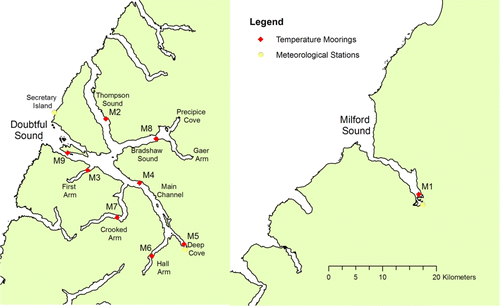
New Zealand's 14 fiords, known for their globally unique and highly diverse marine communities (Witman et al. Citation2004), lie within Fiordland National Park and the wider Te Wahipounamu World Heritage Site. The majority of data collection was carried out in the Doubtful–Thompson Sound complex (hereon referred to as Doubtful Sound), located midway along the Fiordland coast. For comparison purposes, data was also collected in Milford Sound, the northernmost fiord (). Doubtful Sound's main channel is oriented on a northwest to southeast axis, approximately 35 km long from the ocean entrance to the head of Deep Cove, the site of discharge from the tailrace of the Manapōuri Hydroelectric Power Station. The Manapōuri Power Station was constructed in 1969 and became fully operational in 1973. The power station discharged freshwater, originating from Lake Manapōuri, through a single tailrace tunnel between 1969 and 2002. In order to improve the efficiency of the power station (i.e. reduce friction losses from having a single tunnel), a second tailrace tunnel was constructed between 1997 and 2002, becoming operationally effective in 2003.
The station currently operates at a maximum set point of 485 m3s−1, and discharges freshwater into Deep Cove at a rate that is largely dependent on rainfall as there is limited storage within the lakes; discharge varies between 100 and 485 m3s−1 over time with an annual average typically between 300 and 400 m3s−1. The tailrace discharge into the fiord is continuous and over time accounts for twice the freshwater input of natural runoff, which enters Doubtful Sound during episodic rain events through 140 rivers and falls that drain a catchment of 1070 km2.
Temperature measurements
Water temperature data used in this study were collected over a five-year period (March 2005 to March 2010) at nine oceanographic moorings; one in Milford Sound (M1) and eight in Doubtful Sound (M2–M9). The mooring design consisted of a large surface buoy, under which a weighted line holding salinity and/or temperature sensors was attached. The sensor array beneath the buoy was not fixed to the bottom and was free to move vertically with the tide. Each array consisted of 10 instruments deployed at 0.5, 1.0, 1.5, 2.0, 3.0, 5.0, 7.0, 9.0, 11.0 and 19.0 m below the surface. Temperature was recorded at 15 min intervals using RBR XR 420 CT data loggers (accuracy of±0.002 °C) at the M1 and the M4 moorings, and using HOBO water temp pro v2 loggers (Onset®) to an accuracy of±0.2 °C at the other seven moorings. Data were downloaded and data loggers were cleaned and checked at three-monthly intervals.
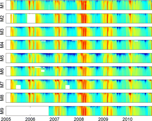
Data from each temperature logger were reviewed to identify missing data when loggers were not deployed during hardware maintenance periods, or due to logger failure. Outliers in the datasets due to apparent electronic hardware malfunction, or in rare cases where the sensor array became tangled or detached from the mooring, were removed from analysis. Temperature data from each mooring location were linearly interpolated in the depth and time dimensions, to represent the irregularly spaced point measurements of water temperature on a regular spacing from the surface to depth, and through time. Interpolated temperature data were used to create coloured 2D plots that revealed patterns in water temperature (colour axis) with depth (y axis) through time (x axis) for each site.
Seasonal segregation
Water temperatures fluctuate over the course of the year, with characteristically warmer and cooler periods following summers and winters respectively. Temperature data were divided into four seasonal groups in order to examine patterns in water temperature in response to drivers (weather and tailrace discharge) during different times of the year. Traditional season boundaries did not appear to best delimit periods of similar water temperatures. We used k-means clustering (Hartigan & Wong Citation1979) to define seasonal boundaries and group similar temperatures. This clustering placed centroids in a space defined by the two dimensions of time (Julian day) and surface (0.5 m) temperature at the M5 mooring in Deep Cove. The centroids located the middle of each season, and points in time equidistant to pairs of adjacent centroids were taken as the division between one season and the next. The season definitions were identified by the clustering algorithm as reducing temperature range within each group compared to traditional terrestrial seasonal boundary definitions.
Meteorological data and tailrace discharge
Near-surface water temperatures potentially respond to a number of physical drivers, including changes in air temperature and the effects of rainfall, wind and tailrace discharge, which all influence LSL characteristics (Gibbs Citation2001). Air temperature, rainfall, and wind speed and direction were measured and recorded over the five-year period March 2005 to March 2010 at two meteorological stations in Doubtful Sound (Deep Cove near the head and Secretary Island near the entrance) and one station in Milford Sound (). Data were downloaded at three-monthly intervals. Data on tailrace discharge based on a conversion of station power output using established machine ratings to derive the discharge rate (in m3s−1 and using half-hourly estimates) were provided by Meridian Energy Ltd. Validations of the ratings have been carried out under controlled discharges and Acoustic Doppler Current Profiler (ADCP) gauging in the tailrace.
Statistical analysis
To test the response of near-surface water temperatures to changes in meteorological conditions and tailrace discharge, water temperature change values were generated by taking the first derivative of the daily mean water temperature. This removed the periodic seasonal fluctuation, isolating the effects of short-term influences. Two seasonal temperature change datasets were used in statistical analysis. The ‘summer’ set contained temperature change values between 9 January and 11 April, while the ‘winter’ set contained temperature change values between 8 July and 7 October. In order to assess affects of physical drivers in isolation, summer and winter datasets were further divided: days with accumulated rainfall greater than or less than average for that season; days with up-fiord wind greater than or less than average for that season; days with air temperature higher or lower than average for that season; and days with tailrace discharge greater than or less than average for that season. The four temperature change sets (summer and winter, higher and lower than average) for each driver were compared graphically to show the distributions in complementary sets. The difference in temperature changes associated with each of the factors investigated was tested for significance by the Mann–Whitney–Wilcoxon U test, which does not require equal sample sizes or normally distributed data.
Results
Water temperatures between 0.5 and 19 m depth showed distinct seasonal patterns common to all sites in both Doubtful and Milford Sounds over the five-year period (). Clustering allocated 24% of measurements to a summer season defined as 9 January to 11 April, 26% to an autumn season defined as 11 April to 8 July, 25% to a winter season defined as 8 July to 7 October and 24% to a spring season defined as 7 October to 9 January.
At all depths, summer water temperatures were higher than winter water temperatures, although seasonal ranges overlapped, particularly at greater depths (). Water temperatures near the surface (top 5 m) spanned a greater range than in deeper waters with differences between the surface and 19 m most evident during the winter months. During the cooler months the sites near the head of Doubtful Sound (e.g. M5, M6) exhibited a more prominent layer of cool water within the top two to three metres of the water column than other sites, such as the head of Milford Sound (M1) and the ocean entrance of Doubtful Sound (M9) and Thompson Sound (M2). Warmer months were periodically interrupted by periods of cooler water temperatures (particularly at depth) that were similar to temperatures observed during the winter months (). Such events were less evident in 2008 (strong La Niña conditions), during which there was a more prolonged warm period compared to the other years including 2007, when El Niño conditions were strongest (National Institute of Water and Atmospheric Research (NIWA) n.d.) ().
Figure 3 Distributions of seasonal surface (0.5 m), mid (3 m, 5 m) and deeper (19 m) water temperature, from the nine moorings. The 0.5 m sensor resides within the surface layer, 3 m and 5 m are exposed to the surface layer during its periodic deepening events, and 19 m is in the oceanic layer below the extreme deepening of the buoyant surface layer. M5 in Deep Cove is at the top of each stack of nine boxes, then M6 in Hall Arm, M4 in the main channel, M3 in First Arm, M9 in the main channel at Bauza Island is in the middle of each stack, then M7 in Crooked Arm, M8 in Bradshaw Sound, M2 in Thompson Sound, and M1 in Milford Sound is lowest. Vertical line in box is the median of the data, the box spans the quartiles, whiskers span 1.5 times the interquartile range, dots beyond that represent outliers.
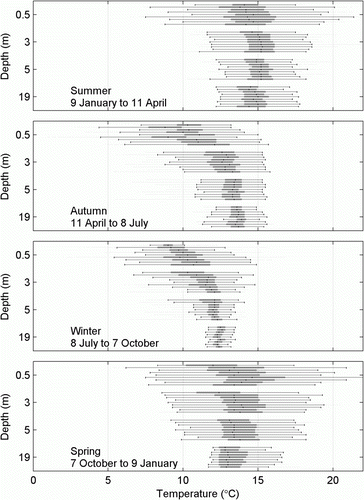
In summer, shallower waters (top 5 m) were warmer (median temperature) than deeper waters across all sites. In spring, there was little difference between shallow and deeper water temperatures, while in autumn and winter the shallower waters were cooler than deeper waters. In summer, shallower waters were slightly warmer (1st and 3rd quartiles 14 °C and 17 °C) than deeper waters (13.5 °C to 16 °C); in winter surface waters were cooler (8 °C to 12.5 °C) than deeper waters (12.5 °C to 13.5 °C) by a greater amount, particularly closer to the tailrace ().
Differences in water temperatures between sites were most apparent in the near-surface water (0.5 and 3 m depth in ). Median water temperature was lowest during the winter at the site nearest the tailrace in Deep Cove (M5 mooring in) (). The M5 mooring also displayed the narrowest range of near-surface water temperatures; the extreme low or high values observed at sites further from the tailrace were not observed at this site. The narrowest interpercentile range (99th–1st percentile) of water temperature at 0.5 m depth (8.5 °C) was observed in Deep Cove (M5) and the widest interpercentile range (14.5 °C) was observed in Crooked Arm (M7; ). Ranges of water temperature at 19 m depth at these same sites were very similar, spanning only 5 °C and 4.5 °C at Deep Cove and Crooked Arm respectively (). Below 3 m depth, there were negligible differences in water temperature between the sites closest to the tailrace (M5 and M6) and the other mooring locations ().
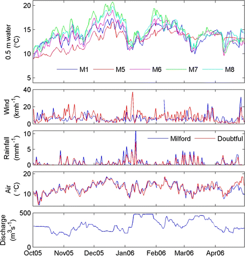
Figure 4 Daily average temperatures of air and water at 0.5 m and 19 m from Milford (M1) and Doubtful (M5) Sounds.
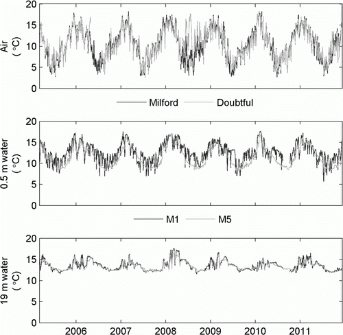
Table 1 Maxima, minima, 1st and 99th percentiles of 0.5 m and 19 m water temperatures throughout Doubtful Sound and in Milford Sound.
Daily mean surface water temperature in inner Doubtful Sound (M5) and Milford Sound (M1) spanned a comparable annual range (about 10 °C), but there was less sub-seasonal variability in Doubtful Sound (M5; 1 °C in winter, 3 °C in summer) than in Milford Sound (M1; 5 °C in winter, 7 °C in summer; ). In the two fiords, water temperature at 19 m had a similar annual range (5.4 °C and 4.2 °C; ) and similar sub-seasonal variability (1 °C in winter, 3 °C in summer, ).
Temperature correspondence to weather and tailrace discharge
Reductions in surface water temperature coincided with reductions in air temperature, increased rainfall and increased wind (e.g. ). Large frontal systems, lasting for days to weeks, introduced short-term variability of a magnitude typical of seasonal variability. As an example, the summer peak in surface water temperature was interrupted in both fiords by a sharp decline of nearly 10 °C over the course of two weeks (from mid-December 2005 to January 2006), and remained low for another four weeks (). The surface temperature decline also coincided with sustained temperature drops of approximately 2 °C to 4 °C in the underlying seawater (as measured at 19 m); seawater temperatures during this summer period were near those observed during winter (). The sharp decline in water temperatures coincided with a distinct frontal system combining a period of high winds, high rainfall and low air temperature during late December 2005 and the first half of January 2006. There was also a significant increase in tailrace discharge, from about 250 m3s−1 to about 485 m3s−1 in early January 2006; however, this increase in discharge followed the drop in water temperatures ().
In addition to this larger-scale event, smaller rainfall events occurred over the weather-band period (two to five days; see Gibbs et al. Citation2000) and coincided with drops in surface water temperature of ~2 °C to 5 °C. Changes in water temperature in line with these events were greatest at sites beyond the M5 mooring in Deep Cove (). Drops in surface water temperature occurred across all sites and did not correspond with changes in the rate of tailrace discharge. Surface waters in Deep Cove (and along the main channel, not shown) were in fact warmer than in the arms of Doubtful Sound or Milford Sound during these events ().
Statistical analysis of subsets of the five-year dataset of water temperature change (categorised according to contrasting meteorological conditions) identified high and low rain and wind as associated with significantly differing rates of change in near-surface water temperatures. The magnitudes of difference were in general small, less than 1 °C per day, but identifiable as statistically different due to sample sizes of 457 (summer days) and 450 (winter days).
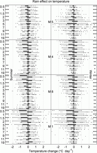
Most comparisons of change in water temperatures were significantly different (P<0.001) between low and high rain conditions (). Rainfall higher than the seasonal average corresponded with decreasing water temperatures at all sites during both summer and winter months. This effect appears to be greatest during the winter months when the temperature of rain (and catchment runoff) is likely to be lower than that of the discharged water that comes from Lake Manapōuri. Changes in temperature between periods of low and high rainfall was greatest near the surface and diminished with depth, with the exception of M5 in Deep Cove during winter months when changes in temperature within the top 2 m were minimal. During rainy periods in summer months, an increase in water temperatures was observed below 9 m depth ().
Figure 6 Effect of rainfall on water temperature change at M5, M4, M8 and M1. Top boxes are high rainfall days, bottom boxes are low rainfall days.
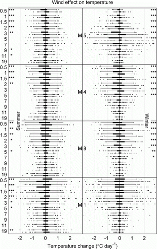
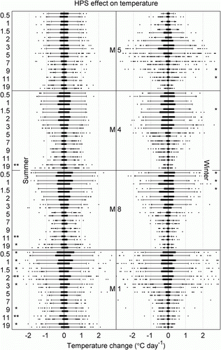
Changes in water temperatures were significantly different (P<0.001) between up-fiord and down-fiord wind conditions. During both summer and winter periods, up-fiord winds were associated with decreasing surface water temperatures, while down-fiord winds were associated with steady or increasing surface water temperatures at the sites in Doubtful Sound (). As was the case for rainfall, the level of temperature change in Deep Cove during winter months was minimal near the surface. No significant changes in temperature were found in Milford Sound during winter, and in the summer the trends were different to those observed in Doubtful Sound. At all sites investigated, differences were most significant down to 5 m depth, and less significant or not significant below that.
Figure 7 Effect of wind direction on water temperature change at M5, M4, M8 and M1. Left-hand plots show summer, right-hand plots show winter. Within each of the eight subplots the 10 pairs of boxes represent the 10 depths at which temperature was measured, and of each of the 10 pairs the top box shows the distribution of temperature changes during up-fiord wind days and the bottom box shows the distribution for down-fiord wind days. Three asterisks indicate a statistically significant difference between up-fiord and down-fiord with P<0.001, two indicate P<0.01 and one indicates P<0.05.
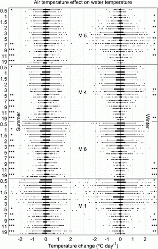
Air temperature in the two sounds had a similar annual range (25 °C) and sub-seasonal variability (14 °C). As was observed in Norwegian fiords (Eilertsen & Skardhamar Citation2006), surface water temperatures were typically higher than air temperatures during the winter months, and were similar to and, at times, lower than air temperatures during summer months (, ). Changes in water temperature were significantly different between warm and cool days during summer at all sites, and less significantly different during winter. In summer, warmer days were associated with water warming more than on cool air temperature days, the significance of the difference often increasing with depth to 19 m. During winter, differences between warmer air days and cooler air days were less significant ().
Figure 8 Effect of air temperature on water temperature change at M5, M4, M8 and M1. Top boxes are warm air temperature days, bottom boxes are cool air temperature days.
Few significant differences in water temperature change were found between higher (>350 m3s−1) and lower (<350 m3s−1) tailrace discharge conditions at any site, either in summer or in winter (). With the exception of very slight winter differences at 9 and 11 m depth, rates of temperature change at M5 (Deep Cove) exhibited no significant difference between discharge rates.
Discussion
Our study describes, for the first time, temporal and spatial patterns in near-surface water temperatures in Doubtful Sound. Over the five-year period, the temporal patterns in near-surface water temperatures were broadly similar across all sites in Doubtful Sound and the site in Milford Sound, indicating that water temperatures respond to climate and weather in a similar manner across the Fiordland region. Water temperatures in the fiords (particularly at the surface) are clearly influenced by the presence of the LSL. However, the effect of the LSL on surface water temperatures varies over time due to seasonal fluctuations in the temperatures of the seawater and freshwater inflows. When the freshwater inflows that constitute the LSL are at the same temperature as the seawater, the LSL has no effect on the temperatures experienced in the surface layers. This is in contrast to the persistent vertical gradient observed in the salinity of surface waters in Doubtful Sound as a function of rainfall combined with continuous tailrace discharge (Gibbs et al. Citation2000; Gibbs Citation2001).
Surface water temperature ranges at the mooring locations varied considerably depending on proximity to the tailrace discharge and whether sites were located within protected, inner reaches of the fiord (e.g. range of 8.5 °C in Deep Cove and 14.5 °C in Crooked Arm). These observed temperature ranges, based on a high sampling frequency (15 min), greatly exceed those previously described for the surrounding coastal waters (Garner Citation1969) and a site in Milford Sound (Greig et al. Citation1988). Garner (1969) reported surface oceanic water temperature at the south of the West Coast differing by only 2 °C between summer and winter. The study by Garner (1969) was limited temporally (one summer cruise, one winter cruise) and spatially (aimed to follow the 100 m bathycline), and hence did not capture the variability that can occur over smaller time frames. Nonetheless, it is clear that water temperatures within the confines of the fiords change considerably more than temperatures in surrounding coastal waters. Our range of surface water temperatures recorded in inner Milford Sound was also double the range of ~6 °C based on daily surface water temperatures recorded by Greig et al. (Citation1988) over the course of a year (1981). The exact location of where temperatures were recorded in this study is unclear, and differences may be partly due to sampling locations (i.e. inner versus outer regions of the sound) and a lower sampling frequency by Greig et al. (Citation1988) that would not have captured within-daily variation in surface water temperatures.
Patterns in near-surface water temperature are clearly linked to changes in the LSL, but unlike salinity the response is dependent on season: the presence of the LSL always results in a strong gradient in salinity, but not necessarily in temperature. Because the LSL can at times have a distinctive temperature signature, the water temperature structure can resemble the LSL (i.e. surface water temperature can penetrate deeper in the inner sound at times, and be more distinguishable in proximity to the continuous freshwater input of the tailrace). Such patterns are most apparent during autumn and winter when incoming freshwater is considerably colder than the underlying seawater. During spring and summer months, water temperature structure is less apparent due to similarity between temperatures of the incoming freshwater and seawater. Monitoring efforts in Doubtful Sound have used temperature structure as a proxy for the extent of the LSL (unpublished monitoring reports on behalf of Meridian Energy, e.g. Cornelisen et al. Citation2007). Our data demonstrate, however, that temperature is not always a good proxy for salinity due to seasonal variation and that, ultimately, both variables need to be measured in order to properly delineate changes in physical gradients associated with LSL dynamics.
Near-surface water temperatures are highly responsive to meteorological events that comprise a reduction in air temperature and high rainfall and winds. During summer, these events can coincide with rapid drops in surface water temperatures of up to 10 °C in some inner regions of the fiords. This level of temperature change, which can occur over a period of days, is greater than the entire seasonal range. For example, sea surface temperatures off the southwest coast of the South Island during early January 2006 were well below the average, and the amount of rainfall was well above average with as much as 900 mm of rain recorded in the first two weeks in Milford Sound (NIWA Citation2006). This regional event led to dramatic changes in temperature near the water surface that coincided with simultaneous drops in air temperature (). The event also coincided with changes in temperature in the underlying oceanic water (19 m depth) that nearly spanned the range of seasonal variability. Gibbs (Citation2001) observed similar events as measured by a temperature sensor at 25 m in mid channel of Doubtful Sound and attributed variability at depth to mixing in the oceanic layer or, possibly, the exchange of waters over the entrance sills. We observed the same response in temperature occurring across all sites, indicating that region-wide frontal systems likely affect all of the fiords in a similar manner; we propose the further mechanism of heat exchange with the atmosphere as potentially responsible for the rapid cooling observed. Future analyses could include quantifying sea-to-atmosphere heat transfer, as has been done in Norwegian fiords (Eilertsen & Skardhamar Citation2006).
The prevalence and intensity of meteorological events may follow the Southern Oscillation Index. Wet and cool conditions were present during a strong El Niño year (2007); whereas consistently dry and warm conditions were observed in the strong La Niña year (2008). Water temperatures followed this pattern. Longer time series through ongoing collection of water temperature data within the fiords will assist in further investigating the role of larger oceanic and climate processes in driving water temperature variability.
There was strong correspondence between changes in water temperatures and the magnitude of rainfall and wind, and weak correspondence with tailrace discharge. The response of water temperature to rainfall is consistent with changes in salinity stratification previously described as LSL deepening events (Gibbs et al. Citation2000; Gibbs Citation2001). In summer the surface layer is warmer than the deeper oceanic water, and summer rainfall thickens that surface layer of warmer water, extending it to greater depth. In winter the buoyant surface layer and incoming freshwater inflows are typically cooler than the underlying oceanic water; thickening of the surface layer takes cool water to depth, and no warming of deeper waters during rainfall is observed. The strong response of water temperatures to rainfall and wind direction is consistent with the combination of rain and strong up-fiord winds leading to deepening of the LSL (Gibbs et al. Citation2000). It is unusual that Milford Sound water temperatures did not respond to wind in the same way that Doubtful Sound water temperatures did, but this may be due to differences in the placement of the wind meters in each sound relative to the sites of water temperature measurement.
There was little correspondence between changes in water temperature and the rate of tailrace discharge. The tailrace discharge represents a continuous input of water from Lake Manapōuri, and changes in the discharge rate within the normal range of operation result in much smaller changes in LSL thickness than episodic rainfall events combined with up-fiord winds (Gibbs et al. Citation2000). In the absence of rainfall and wind the tailrace maintains a relatively constant LSL that is about 2 m to 4 m thick (depending on proximity to Deep Cove and antecedent rainfall). The similarity in water temperatures observed between periods of low and high discharge rates corroborates these observations and indicates that a recently consented maximum discharge rate (a periodic increase of 65 m3s−1) will have little influence on water temperatures in Doubtful Sound.
Although changes in the discharge rate appear to have little effect on changes in water temperature, the continuous discharge of freshwater into Deep Cove does affect water temperatures, particularly within the inner sound. In autumn and winter, the continuous inflow of freshwater from Lake Manapōuri results in lower surface water temperatures than would be observed in its absence. This is most apparent when comparing sites such as Bradshaw Sound and Milford Sound to Deep Cove during periods of dry weather. The continuous discharge from Lake Manapōuri also results in much lower short-term variability in surface water temperatures in Deep Cove than in the fiord arms and in Milford Sound, where surface waters can be considerably cooler or warmer than in Deep Cove depending on the weather conditions. The continuous discharge of freshwater into the sound therefore dampens the effects that meteorological events would otherwise have on water temperatures through their influence on the LSL.
We acknowledge that many drivers collectively influence the oceanographic conditions at any point in time. Further research incorporating frequency-domain analyses, statistical modelling and numerical hydrological modelling will assist in further understanding the mechanisms driving water temperatures in New Zealand fiords. Initial results of frequency domain analysis (not shown) reveal that coherence of water temperature to the drivers investigated varied with site, depth and frequency/period, with all drivers having coherence at some frequency. Lag between driver and response increased with depth for meteorological drivers, but decreased with depth for tailrace discharge and tide. Coherencies are predominantly with meteorological drivers at the surface and with tide at depth. The length of the oceanographic and meteorological data series available in Doubtful Sound is exceptional and continues to be extended. Longer time series will facilitate investigations of processes potentially influencing water temperatures that operate over longer time scales (e.g. Southern Oscillation).
Biological implications
Given the strong gradients in water temperature observed in the fiords, it is important to consider the potential influence of changes in water temperature on the biology of the fiords. The frequent coincidence of gradients in salinity and temperature associated with the LSL makes it difficult to isolate the influence of temperature on biological processes. Unlike salinity, water temperatures fluctuate as a function of season. Organisms are likely to be more tolerant of water temperature fluctuations, which more often can span an organism's range, than of salinity fluctuations, which span nearly the full spectrum of salinity between freshwater and seawater. Indeed, salinity has been identified as the key physical variable controlling the upper depth limit of black corals (Kregting & Gibbs Citation2006; Grange Citation1991), the vertical distribution of predators and grazers (Witman & Grange Citation1998; Lamare et al. Citation2009), spatial patterns in community diversity (Smith & Witman Citation1999), and organism distribution and community composition within the intertidal zone (Boyle et al. 2001) and shallow soft sediments (Tallis et al. Citation2004; Rutger & Wing Citation2006; McLeod & Wing Citation2008). A number of these studies have involved experiments to further confirm the effects of reduced salinity on mortality (Kregting & Gibbs Citation2006; McLeod & Wing Citation2008).
Water temperature is more likely to affect biological processes of eurohaline organisms. For example, it is possible that the observed patterns in water temperature affect growth of ephemeral macroalgae species that are abundant in shallow waters (e.g. Ulva pertusa; Cornelisen et al. Citation2007). Cooler temperatures in the inner fiord regions, for example, may partly explain lower standing stocks of eurohaline macroalgae observed in the inner sounds (Wing et al. Citation2008). The observed temperature gradients may also influence reproductive processes (spawning) in eurohaline invertebrates such as barnacles and mussels (Minchen Citation1987) that are also widely distributed throughout the fiords. Further research that addresses the combined effects of multiple physical variables is required to assess the extent to which the gradients in water temperatures described in this study contribute to biological processes (and patterns) observed along the fiords' rock walls.
The spatial and temporal patterns of water temperature documented in this study are also important to consider with regard to Doubtful Sound's resident population of bottlenose dolphins (Tursiops truncatus). Crooked Arm and Bradshaw Sound have been identified as critical dolphin habitats for socialising and resting (Higham & Lusseau Citation2003), which may be related to the fact that these same locations exhibit the warmest surface water temperatures, particularly during the calving months. However, these areas of the fiord are also susceptible to the largest changes in water temperature during meteorological events and, in very short time frames, can become colder than other areas of the fiord. Extension of long-term records of water temperatures in parallel with ongoing dolphin surveys are required to more fully understand the links proposed (Elliott et al. Citation2011) between temporal and spatial patterns in water temperature and the biology of Doubtful Sound's resident dolphins.
Acknowledgements
We thank Meridian Energy Ltd for supplying salinity and temperature data from their ongoing monitoring programme in Doubtful and Milford Sounds. Assistance by Paul Meredith (University of Otago) and Ian Maze (NIWA) in the maintenance of moored instrumentation and provision of data was greatly appreciated. We thank Barrie Forrest and James Holloway for helpful reviews. Funding for the production of this manuscript was provided by the Cawthron Internal Investment fund.
References
- Boyle , MC , Jillett , JB and Mladenov , PV . 2001 . Intertidal communities in Doubtful Sound, New Zealand: changes over time . New Zealand Journal of Marine and Freshwater Research , 35 : 663 – 673 .
- Braby , CE and Somero , GN . 2006 . Following the heart: temperature and salinity effects on heart rate in native and invasive species of blue mussels (genus Mytilus) . Journal of Experimental Biology , 209 : 2554 – 2566 .
- Cairns , DK , Gaston , AJ and Huettmann , F . 2008 . Endothermy, ectothermy and the global structure of marine vertebrate communities . Marine Ecology – Progress Series , 356 : 239 – 250 .
- Choi , DH , Park , JS , Hwang , CY , Huh , SH and Cho , BC . 2002 . Effects of thermal effluents from a power station on bacteria and heterotrophic nanoflagellates in coastal waters . Marine Ecology – Progress Series , 229 : 1 – 10 .
- Cornelisen C , Clark K , Jiang W , Goodwin E , Roberts B , Dunmore R 2007 . Assessment of 2MTT discharge effects in Doubtful Sound: physical and biological monitoring. Prepared for Meridian Energy. Cawthron Report No.1390. 62 p. + appendices .
- Cornelisen , CD , Wing , SR , Clark , KL , Bowman , MH , Frew , RD and Hurd , CL . 2007 . Patterns in the delta C-13 and delta N-15 signature of Ulva pertusa: interaction between physical gradients and nutrient source pools . Limnology and Oceanography , 52 : 820 – 832 .
- Eilertsen , HC and Skardhamar , J . 2006 . Temperatures of north Norwegian fjords and coastal waters: variability, significance of local processes and air-sea heat exchange . Estuarine Coastal and Shelf Science , 67 : 530 – 538 .
- Elliott , RG , Dawson , SM and Henderson , S . 2011 . Acoustic monitoring of habitat use by bottlenose dolphins in Doubtful Sound, New Zealand . New Zealand Journal of Marine and Freshwater Research , 45 : 637 – 649 .
- Garner , D . 1969 . The seasonal range of sea temperature on the New Zealand shelf . New Zealand Journal of Marine and Freshwater Research , 3 : 201 – 208 .
- Gibbs , M . 2001 . Aspects of the structure and variability of the low-salinity-layer in Doubtful Sound, a New Zealand fiord . New Zealand Journal of Marine and Freshwater Research , 35 : 59 – 72 .
- Gibbs , MT , Bowman , MJ and Dietrich , DE . 2000 . Maintenance of near-surface stratification in Doubtful Sound, a New Zealand fjord . Estuarine Coastal and Shelf Science , 51 : 683 – 704 .
- Grange K 1991 . The underwater environment of Doubtful Sound: results from an instrument array moored from November 1987 to June 1989 . New Zealand Oceanographic Institute .
- Green , BS and Fisher , R . 2004 . Temperature influences swimming speed, growth and larval duration in coral reef fish larvae . Journal of Experimental Marine Biology and Ecology , 299 : 115 – 132 .
- Greig , M , Ridgway , N and Shakespeare , B . 1988 . Sea surface temperature variations at coastal sites around New Zealand . New Zealand Journal of Marine and Freshwater Research , 22 : 391 – 400 .
- Hartigan , J and Wong , M . 1979 . A k-means clustering algorithm . Journal of the Royal Statistical Society, Series C (Applied Statistics) , 28 : 100 – 108 .
- Kaschner , K , Watson , R , Trites , AW and Pauly , D . 2006 . Mapping worldwide distributions of marine mammal species using a relative environmental suitability (RES) model . Marine Ecology – Progress Series , 316 : 285 – 310 .
- Keser , M , Swenarton , JT and Foertch , JF . 2005 . Effects of thermal input and climate change on growth of Ascophyllum nodosum (Fucales: Phaeophyceae) in eastern Long Island Sound (USA) . Journal of Sea Research , 54 : 211 – 220 .
- Kregting , LT and Gibbs , MT . 2006 . Salinity controls the upper depth limit of black corals in Doubtful Sound, New Zealand . New Zealand Journal of Marine and Freshwater Research , 40 : 43 – 52 .
- Lamare , MD , Channon , T , Cornelisen , C and Clarke , M . 2009 . Archival electronic tagging of a predatory sea star: testing a new technique to study movement at the individual level . Journal of Experimental Marine Biology and Ecology , 373 : 1 – 10 .
- Lee , KS , Park , SR and Kim , YK . 2007 . Effects of irradiance, temperature, and nutrients on growth dynamics of seagrasses: a review . Journal of Experimental Marine Biology and Ecology , 350 : 144 – 175 .
- MacKenzie , L and Adamson , J . 2004 . Water column stratification and the spatial and temporal distribution of phytoplankton biomass in Tasman Bay, New Zealand: implications for aquaculture . New Zealand Journal of Marine and Freshwater Research , 38 : 705 – 728 .
- MacLeod , CD . 2009 . Global climate change, range changes and potential implications for the conservation of marine cetaceans: a review and synthesis . Endangered Species Research , 7 : 125 – 136 .
- Mann KH , Lazier JRN 1991 . Dynamics of marine ecosystems. Biological-physical interactions in the oceans . Blackwell Scientific Publications , Boston , MA . 466 p .
- McLeod , RJ and Wing , TR . 2008 . Influence of an altered salinity regime on the population structure of two infaunal bivalve species . Estuarine Coastal and Shelf Science , 78 : 529 – 540 .
- Minchin , D . 1987 . Sea-water temperature and spawning behaviour in the seastar Marthasterias glacialis . Marine Biology , 95 : 139 – 143 .
- NIWA El Niño and climate forecasting . n.d http://www.niwa.co.nz/our-science/climate/information-and-resources/clivar/elnino (accessed 18 July 2012) .
- NIWA 2006 . National Climate Summary – January 2006 . http://www.niwa.co.nz/sites/default/files/import/attachments/0601sum.pdf (accessed 18 July 2012) .
- O'Connor , MI , Bruno , JF , Gaines , SD , Halpern , BS , Lester , SE , Kinlan , BP and Weiss , JM . 2007 . Temperature control of larval dispersal and the implications for marine ecology, evolution, and conservation . Proceedings of the National Academy of Sciences of the United States of America , 104 : 1266 – 1271 .
- Higham , JS and Lusseau , D . 2003 . Managing the impacts of dolphin-based tourism through the definition of critical habitats: the case of bottlenose dolphins (Tursiops spp.) in Doubtful Sound, New Zealand . Tourism Management , 25 : 657 – 667 .
- Rutger , SM and Wing , SR . 2006 . Effects of freshwater input on shallow-water infaunal communities in Doubtful Sound, New Zealand . Marine Ecology – Progress Series , 314 : 35 – 47 .
- Smith , F . 2001 . Historical regulation of local species richness across a geographic region . Ecology , 82 : 792 – 801 .
- Smith , F and Witman , JD . 1999 . Species diversity in subtidal landscapes: maintenance by physical processes and larval recruitment . Ecology , 80 : 51 – 69 .
- Stanton B , Pickard G 1981 . Physical oceanography of the New Zealand fiords . New Zealand Oceanographic Institute . Wellington New Zealand 36
- Stanton , BR . 1986 . Winter oceanograpic observations in some New Zealand fiords . New Zealand Journal of Marine and Freshwater Research , 20 : 299 – 314 .
- Tallis , HM , Wing , SR and Frew , RD . 2004 . Historical evidence for habitat conversion and local population decline in a New Zealand fjord . Ecological Applications , 14 : 546 – 554 .
- Vogel S 1994 Life in moving fluids: the physical biology of flow . Princeton University Press , Princeton , NJ . 467 p.
- Whalan , S , Ettinger-Epstein , P and de Nys , R . 2008 . The effect of temperature on larval pre-settlement duration and metamorphosis for the sponge, Rhopaloeides odorabile . Coral Reefs , 27 : 783 – 786 .
- Wing , SR , McLeod , RJ , Clark , KL and Frew , RD . 2008 . Plasticity in the diet of two echinoderm species across an ecotone: microbial recycling of forest litter and bottom-up forcing of population structure . Marine Ecology – Progress Series , 360 : 115 – 123 .
- Witman , JD , Etter , RJ and Smith , F . 2004 . The relationship between regional and local species diversity in marine benthic communities: a global perspective . Proceedings of the National Academy of Sciences of the United States of America , 101 : 15664 – 15669 .
- Witman , JD and Grange , KR . 1998 . Links between rain, salinity, and predation in a rocky subtidal community . Ecology , 79 : 2429 – 2447 .
