
ABSTRACT
Aotearoa New Zealand is a land and cultures surrounded by one of the planet’s larger marine exclusive economic zones per capita. Understanding, living within and utilising this domain requires a well-developed knowledge of the physical oceanography – fate, provenance and transfer of ocean-water, material and energy. In the Aotearoa New Zealand context, understanding and utilising the environment through science also requires that Māori have a stake in the science and a pathway to connecting with their mātauranga. The pūtahitanga (intersection) of mātauranga Māori and western science perspectives brings challenges for implementation of the Vision Mātauranga framework for physical oceanographic science. Here we discuss the drivers and key themes for the pūtahitanga and propose a mahere kaupapa/plan bound by: (i) climate, (ii) decolonisation, (iii) shared language, (iv) data sovereignty, and (v) developing a cohort who can lead the field in the coming decades.
TUHINGA-WHAKARĀPOPOTO
Kua karapotia te whenua me te ahurei o Aotearoa e te ohaoha aukatinga o te moana nunui tuarua o te ao mō ia ūpoko. Kia mārama, kia whakatīnana hoki ai tēnei tauwāhi me whakawhānui ngā mōhiotanga mō te mātai aumoana – te tīmatanga me te whakawhitinga o te wai, ngā rauemi, me ngā pūngao. Nō roto mai te horopaki o Aotearoa, mā te putaiao ko māramatanga me te whakatīnanatanga i te taiao, nā tēnei āhua he wāhi mō Ngāi Māori ki te tūhono ō rātou matauranga ki ō rātou huanui hoki.
Ko te pūtahitanga o ngā mātauranga Māori me ngā mātauranga pūtaiao Pākehā e wero tonu ana kia whakatīnana te pou tarāwaho o te Titirohanga Mātauranga mō te mātai aumoana. Koinei te matapakinga mō ngā pūtake me ngā mōraro matua mō te pūtahitanga e tūtohu ana he mahere: (i) purenga ihomatua, whakapurenga ngā ihomatua o te mātai aumoana, (ii) whakaahu he reo tohatoha, (iii) ko ētahi raraunga ka mau ake a Ngāi Māori (ā whānui nei), (iv) whakaahu te pito mata o tētahi rāngai kia arahi te whīra mō ngā tau e heke mai nei.
Introduction
Aotearoa New Zealand was the last large landmass to be populated by humans, achieved through substantial innovation by Polynesian marine navigators (Anderson Citation2017). In a time before GPS, satellites and computational weather forecasts, successful long-distant voyages required significant empirical experience and technology as well as resilience. Thus, understanding the physics of our oceans is one of the cornerstones for having a knowledge-based connection between seas and land (Stevens and O’Callaghan Citation2015). Māori hold this knowledge and from their perspective, to have a meaningful stake in the science, there must be ways to engage with the science on shared and equal terms.
In a science in Aotearoa New Zealand context, sharing and equity require an understanding of mātauranga Māori – a holistic knowledge system originating from Māori ancestors, which adapts and changes but does not lose its integrity nor sense of origin (e.g. Broughton et al. Citation2015; Hikuroa Citation2017). Like working with non-linear equations of motion, the holistic approach considers all the important themes and connects them. Mātauranga Māori encompasses not only what is known but how it is known and includes Māori cultural world views, language, principles and practices (Paul-Burke Citation2017). In the early 2000s, the government ministry responsible for science at the time developed the so-called ‘Vision Mātauranga’ policy framework to provide strategic direction for research of relevance to Māori (MoRST Citation2005) so as to ‘use mātauranga Māori to inform research, science and technology’. In the present context it is important to acknowledge pioneering work (e.g. King et al. Citation2008) that lay the foundation for making such connections.
Here we examine the pūtahitanga (convergence/intersection) of physical mātai aumoana (oceanography) and mātauranga Māori. We suggest the pūtahitanga be framed as mātauranga supported by the tools of western science. This is a way of separating aspects of mātauranga Māori that connect with western science from the realms of philosophy and religion. Thus, the focus is on pūtahitanga providing a set of tools for, say in the case of physical oceanography, understanding topics like ocean currents, waves, tides, stratification and climate and directly informs biophysical oceanography and ecology which in turn underpins things like fisheries and aquaculture. We focus on physical oceanography here because it is at the more challenging end of the spectrum of marine sciences in terms of connections to mātauranga Māori. It can be viewed as the ‘western science’ perspective on how the ocean works.
As described by Mercier (Citation2018), terms like ‘mātauranga Māori’ and ‘western science’ are multi-dimensional and mean different things to different viewpoints. Many of the themes in connecting the areas of knowledge have commonality (Clapcott et al. Citation2018) and so we consider these ideas in an ocean setting and describe the general drivers of why there is a need to connect perspectives and then explore a range of themes specific to the pūtahitanga. These themes include climate, decolonisation, language, data ownership (sovereignty) and capacity. We then close by proposing initiatives that potentially can accelerate this connection using a mahere kaupapa/project plan.
There are a number of whāinga/drivers for why we seek to connect between mātauranga Māori and physical science perspectives of the marine environment. It can, for example, help local communities particularly in terms of kaitiakitanga/active guardianship. Every iwi/hapū (tribal division) has a coastline, stream, river or lake in their rohe/district and all require the tools and results of western science to be able to be listened to and successfully participate in the decisions and legal processes relevant to issues surrounding water, water quality, coastal development and climate change. Many hapū are not able to successfully challenge or defend their right as kaitiaki as they don’t have the access to these western science tools. As applicants in resource consent cases often have the access to science and, be it computer modelling or observational studies, it puts the hapū at a disadvantage. If the tools of physical oceanography can come along-side mātauranga Māori supporting kaitiakitanga it will assist the many hapū around the country that are facing these challenges.
Māori-owner companies are arguably unique (Jones et al. Citation2017) in that they are driven not only by financial outcomes but, to a greater or lesser extent, by principles of kaitiakitanga (environmental responsibility), manaakitanga (capability building), and taonga tuku iho mō ngā uri whakatipu (guardianship of resources for future generations). This has synergies with kaitiakitanga as a principle and has direct connection to the impact of science in that there is a wider awareness of the science results and motivations and also greater input into decisions that drive what science is being done.
From a legal stand-point the Treaty of Waitangi provided a basis for the Wai 262 claims to intellectual property and science (Waitangi Tribunal Citation2011). This ruling was precedent-setting in that it was the first to focus on the present and future relationships between the crown and Māori in terms of use of Māori knowledge. In addition, the management of coastal seas has been at the forefront of legal exploration of the relationship between Māori and the Crown, most recently through the Foreshore and Seabed Act 2004 and the Marine and Coastal Area (Takutai Moana) Act 2011 which recognises the customary rights and relationship of Māori for their traditional marine and coastal area while continuing to provide free public access, fishing and other recreational activities for all New Zealanders (Takutai Moana Citation2011; Sullivan Citation2017).
Kaupapa/Themes
Āhuarangi/Climate
Past, present and future knowledge of the ocean is contained in both mātauranga Māori and physical oceanography. Whakataukī oral traditions provide evidence of past usage and awareness of the marine environment (Whaanga et al. Citation2018) so that mōteatea and waiata tāwhito (traditional chants; karakia/prayers); pūrākau (traditional stories) and whakataukī (proverbs) provide vehicles for the live transmission of knowledge from one generation to the next (Whaanga et al. Citation2018) and, importantly, record evidence of past usage and awareness of marine environments through time.
Around 39 generations prior to the date of documentation, Kupe, known as the discoverer of Aotearoa New Zealand (Te Matorohanga Citation1913), is recorded as making the journey from Tahiti driven by the search for kai moana/seafood and informed by mātauranga Māori as to the likelihood of finding land. The success of this voyage and subsequent journeys would have required excellent understanding of weather, the seasons and climate. Past climate changes have been linked to navigation whereby particular climate configurations better support trans-Pacific navigation enabling migration and colonisation (e.g. Goodwin et al. Citation2014; Anderson Citation2017). There are broad connections between the timing of availability of maritime technology (i.e. the ability to sail upwind) and climate structure changes relevant to Aotearoa New Zealand over the last millennium (Lorrey et al. Citation2014) and thus motivate pūtahitanga between physical oceanography, climate and mātauranga Māori.
This changing climate is now central to regional social policy and action over the coming decades as sea level rise make increasing inroads into the sustainability of Pacific Island nations (Storlazzi et al. Citation2018). Māori intergenerational awareness enables the mātauranga Māori world-view to directly engage with climate timescales. Impacts will extend beyond ‘simple’ sea level and take in other non-linear interactions such as increased damage from storms and associated reduced availability of freshwater. Pasifika island communities will be potentially more able to respond to this change if they can make knowledge-based decisions based on the science underpinning the drivers, impacts and mitigation options. Pūtahitanga acts as a connection between the ocean and the Māori-Pasifika-Pākehā continuum.
Combining celestial information with wind and ocean waves and swell propagation have long been known to be a viable navigation tool. By the mid-1960s oceanographers could quantify how wave energy propagates across ocean basins (Snodgrass et al. Citation1966). A comparison of western and indigenous scientific knowledge of wave propagation (Genz et al. Citation2009) suggests that much of this was contained within mātauranga for at least a millennium prior. The emphasis on oral and graphical transfer of knowledge, rather that written text, is often identified as a point of difference between western science and mātauranga Māori. However, the Wapepe (indigenous Wave model) of the Marshall Islands and elsewhere has much in common with graphical wave propagation descriptions developed by western science (Genz et al. Citation2009). Such graphical representations have similarities with science communication using pictographic representations or data visualisation.
This example from the Marshall Islands brings to the fore the place and role of Pasifika people. While they are not identified in the Vision Mātauranga overview (MORST Citation2005), with the marine context in mind, it is straightforward to see why Pasifika should be considered in any socio-cultural context for physical oceanography in the Pacific region. What makes the voyages of Kupe and his contemporaries all the more remarkable is it is one thing to navigate by wave patterns in an archipelago where the bathymetry will be a dominant and invariant factor, it is another to consider wave-based navigation across the deep, mostly island-free waters around Aotearoa New Zealand where synoptic weather patterns and the very large islands will dominate. This points to the breadth of mātauranga Māori.
Purenga ihomatua/Decolonisation
From a Pākehā view of pūtahitanga, the Tahitian navigator Tupaia provides the superficially perfect model for championing the value of cross-cultural connections as he was a significant element in James Cook’s first voyage of exploration and mapping which clearly relates to the evolution of western science. However, Tupaia’s contributions are made complicated by association with cultural first-contact and the wider impacts of colonisation (Scanlan Citation2017). Furthermore, by focusing on the European-Pasifika partnership it takes the emphasis away from Māori and Pasifika navigators who made significant advances in their own right.
In the early part of the last millennium the voyager Toi-te-Huatahi (or Toi-kai-rākau, Toi for short) was known to be exploring the northern regions of Aotearoa New Zealand. Ocean flows that approach Aotearoa New Zealand in this sector evolve from the East Australia Current and the Tasman Front carrying water from the east coast of Australia. This becomes the East Auckland Current which travels down the eastern side of the North Island sustaining a sequence of large eddies (Roemmich and Sutton Citation1998) including offshore of the Bay of Plenty. Toi-te-Huatahi lived about A.D. 1150 and stories tell of him searching for his grandson Whatonga. On arrival in Aotearoa he is reported to have settled at Kaputerangi in Whakatāne (McLintock Citation1966) and his influence and descendants extend along the eastern coastline of the North Island including Northland, Hauraki Gulf, Tauranga, Whakatāne through to the East Cape. His descendants are referred to as ngā tini o Toi and the Bay of Plenty is also known as Te Moana-a-Toitehuatahi.
More recently, Pius ‘Mau’ Piailug (Papa Mau) from Micronesia worked with mātauranga in a physical oceanographic context and recently enough (1970s) to overlap with modern oceanography (Scanlan Citation2017). While, voyaging revivalists found they could build a vessel, his seafaring and wayfinding knowledge was critical when it came to navigation without modern technology. Communication of the priority and skills of these navigators and explorers to younger Māori and Pasifika scholars is vital for the development of this intersectional topic. As with origin stories from any culture, there is power in being able to connect with past perspectives, history and language. Many origin stories have a connection to navigation. This is not surprising as the first peoples to arrive in Aotearoa New Zealand travelled great distances in challenging conditions. Clapcott et al. (Citation2018) describe effective pathways for communicating western science perspectives to Māori with a strong emphasis on location. The challenge from an oceanographic perspective is the water itself crosses iwi/tribal boundaries. Overlapping of interests is more common than not and iwi resource management plans typically engage with neighbouring interests. If for example, one is studying the East Auckland Current, running from the northern tip of Aotearoa NZ to past East Cape, then there is an array of iwi that might potentially be engaged with in order to gain approvals and communicate science. However, once physical sampling is initiated, as with local council approval, the jurisdiction becomes clearer.
Every colonised state is unique but there are common themes in their interface with science. Consequently, there is a role for pūtahitanga to support decolonisation by connecting the Aotearoa New Zealand science-mātauranga Māori nexus with other situations internationally. Australia, with its very large land area, also has a large and relatively heterogenous set of indigenous languages and little in the way of an original legal framework for sharing land and resources. Despite this, there is evidence of these groups having governance over large areas of ‘sea country’ (Yunupingu and Muller Citation2009). A 2002 report into indigenous perspectives on the Australian Oceans Policy opens with text that could be ported directly to the present setting.
Indigenous people have a culture that relates to the land and sea in a holistic way that also includes connections to powerful and significant places. However, the emphasis that is now put on management of discrete sites can overlook and diminish Indigenous connections to the environment as a whole. (National Oceans Office Citation2002)
Te Reo/Language
Any true interdisciplinary collaborative work requires a shared language as a starting point (Bracken and Oughton Citation2006). At a fundamental level, pūtahitanga is about development of a shared vocabulary. Descriptions of Kupe’s battle over resources with Te Wheke o Muturangi, a giant octopus, tell of a pursuit across the oceans that ends with the creature being chased into Te Moana o Raukawa (Cook Strait). Kupe, aware of the turbulence of the Strait (Stevens Citation2018) lures Te Wheke to the relative calm of a nearby bay where the octopus is finally subdued – its eyes becoming the Brothers Islands (Grace Citation2019). In fluid mechanics, when talking about Kelvin-Helmholtz billowing that is a key phenomenon in ocean mixing, the coherent structures that form get referred to as ‘cat’s eyes’ (Chang et al. Citation2016). These structures are just one component of the variability driven by the strong tidal currents induced by the confluence of the narrowing of the greater Cook Strait, and the close synchronisation of the propagation of the ‘tidal’ wave around the combined islands of Aotearoa New Zealand (Bowman et al. Citation1980).
King et al. (Citation2008) and Whaanga et al. (Citation2018) provide some examples of shared language. Here we seek to build on this () with te reo Māori equivalents to common oceanographic terminology (e.g. types of tides, waves, heat, salt, currents, cold, ice, weather). Some concepts are not so directly described (such as pressure, stratification, ocean productivity, deep time, space, research, continental shelf) while other words around methodology can be quite general (e.g. data). Alignment of words from different languages comes with the potential of losing the origin of the words. Conversely, discovery science generates new concepts that potentially won’t have specific terminology in any language. Certainly, there is scope to build on the list of terms, and their origin and context, developed here.
Table 1. Te Reo Māori – English oceanographic vocabulary/papakupu/glossary (Moorfield Citation2019), see also Mercier (Citation2018) for more general terms.
Raraunga/Data sovereignty
Oral traditions describe how Te Kawau-a-Toru, a companion of Kupe, becomes ensnared (King-Turner Citation1970) at Te Aumiti (French Pass), the narrow stretch of water separating Rangitoto ki te Tonga (D’Urville Island) from the mainland. Kawau is captured by the substantial vertical eddy structure present which is dangerous to anyone drifting through other than at slack-water (Stevens et al. Citation2021). In the origin story, Kawau ends up becoming the shoal region that significantly constricts the ocean passage between the mainland and the island.
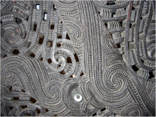
These days data for tidal streams for locations like Te Aumiti (French Pass) are commonly shared (LINZ Citation2019). In ocean science, especially the physical sciences, there are growing calls for large datasets collected by costly taxpayer funded research programmes to be made open to all uses and government declarations support this to an extent (NZ Goal Citation2015). However, generally speaking, because of past experiences, Māori are cautious about the subordination and/or misrepresentation of Māori knowledge. This raises questions such as how do Māori influence the parameters for the use of such data (Hudson et al. Citation2016)? Furthermore, what are the intellectual property rights in the context of research and the dissemination of mātauranga-based knowledge (Kukutai and Taylor Citation2016; Smith et al. Citation2016)? Hui like the Māori Data Futures workshop (SFTI Citation2018) identified themes around control, mātauranga-accessed, multiplicity of formats (including digital, analogue, biological, kōrero/speech, and whakairo/carving – ), understanding the non-financial value of the data, and potential to support innovation, and that the worth of the data be used to support Māori growth.
Figure 1. Whakairo/carving on the stern of a nineteenth-century waka taua/Maori war canoe in the collection of the Auckland Museum, containing a number of elements with oceanographic relevance (image: Kahuroa/public domain).
This issue is not special to Aotearoa New Zealand as many indigenous cultures are making headway at reclaiming their intellectual property rights, for example in Australia (Janke and Sentina Citation2017). As a result, not all knowledge derived via pūtahitanga can be expected to be openly accessible. Māori customary knowledge that remains today is highly valued and, in some cases as a direct result of the scarcity and loss of knowledge (Forster Citation2012). Mātauranga Māori is regarded as ngā taonga tuku iho (treasures handed down by the ancestors) and so certain knowledge has been reserved and protected from the public eye (Smith et al. Citation2016). This is common in applied physical oceanographic science, where data are sometimes protected due to commercial restrictions, publishing priority or (unintentionally) through lack of resources.
Āheitanga/Capacity
In the oral stories related to Kupe, there is a description of taniwha, Āraiteuru and Niua, who lived at the heads of the Hokianga harbour entrance. These taniwha were left by Kupe to guide returning waka to safe landing, but if angered they whip the sea up into a storm (Te Ahukaramū Citation2005). This provides context for the challenging navigation conditions across the Hokianga bar created by shoaling waves, the flow out of the harbour, and the stage of the tide (Leach Citation2006). This story connects seemingly academic issues like energy dissipation during wave-current interaction (Gallop et al. Citation2018) with the practicalities of navigating in and out of a safe port. It provides a pathway to bridging the ‘cultural interface’ (Nakata Citation2011) connecting mātauranga Māori with physical oceanography in a way that works for potential Māori scholars.
Assuming a fifteen-year period is required from the end of primary school, through a graduate degree, and then some science training with aspects of mātauranga Māori included, and with the Vision Mātauranga initiative only starting to become cemented in the mid-2010s, the science sector is in the middle of a systematic capacity vacuum. To some extent, this is necessary in order to drive a resource-poor system to invest in developing the required capacity. Physical oceanography has modest representation in the university system which is sensible for academic replication but not good for injecting ocean physics-aware people into the Aotearoa New Zealand knowledge ecosystem (Stevens and O’Callaghan Citation2015). This creates a feedback that opposes self-correction. Areas good at, or better able to develop, mātauranga Māori synergies outcompete areas that are less good at, or less able, or less willing and so there is less investment in the poorly supported areas.
While Māori representation in the sciences is growing (), there are few Māori students going into physics. Of these, the number of students then going onto have an interest in physical oceanography is virtually zero. ‘Fund a scholarship’ is a typical response but this requires a meaningful and engaged senior Māori scientist to supervise and/or mentor. As noted by McAllister et al. (Citation2019) and Naepi (Citation2019), Māori and Pasifika are poorly represented in the research/academic sector. A consequence is researchers with Māori interests and perspectives are highly over-subscribed in terms of projects they are asked to contribute to, and get co-opted into. Potentially, this is at the cost of their own specialties and initiatives.
Figure 2. Percentage of Principal Investigators applying for Marden Fund support who identify as Māori (Marsden Fund Citation2018).
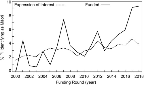
This scarcity of Māori and Pasifika researchers generates a feedback loop. Physical oceanography science typically requires a high level of mathematical competency. Few data are available on Māori participation in mathematics or the physical sciences. The Marsden Fund run by the Royal Society Te Apārangi (Gush et al. Citation2018) makes available numbers on proposal success rates indicating Māori success rates are of the order of 10% () although oceanography projects are rare. For school ages, international surveys of competency point to a correlation with socio-economic well-being when quantifying low equity outcomes (Caygill et al. Citation2016; May et al. Citation2016).
Aotearoa New Zealand has one of the world’s largest Exclusive Economic Zones – something that becomes even more apparent when normalised by population. Economic drivers are one pathway for justifying pūtahitanga, especially as the Māori view of the ocean makes distinctions around access to, and availability of, kai moana. Applied oceanography has connections to kai moana, both for wild fisheries and aquaculture. For example, waves, tides and weather are fundamental aspects of mātauranga Māori, particularly in terms of food gathering. Maramataka/lunar calendar provides a guide for the best times to go fishing. Consequently, the connection has implicitly already happened in that there is substantial Māori ownership and participation in fisheries and this industry, while strongly informed by experience, is also open to science (Ogilvie et al. Citation2018). Another example is the rock lobster Jasus edwardsii which is the basis of Aotearoa New Zealand’s largest live export industry with substantial Māori ownership and participation. Because of its long oceanic larval lifetime (up to nearly two years), the population dynamics of the species is strongly influenced by oceanographic processes (Chiswell and Booth Citation2017) and so subject to phenomena like marine heat waves and El Niño-Southern Oscillation. In a reversed perspective, native eels (tuna) are long-lived in streams but navigate ocean currents across a wide range of latitudes – possibly as far north as 20°S (Kuroki et al. Citation2009) and are highly valued by fishers in local communities (McCarthy et al. Citation2014).
Discussion and mahere kaupapa/Project plan
The focus here is finding and growing/whakatipu – the pūtahitanga – between western science and mātauranga Māori. So, rather than looking at points of difference between mātauranga Māori and western science, we start with recognition that they overlap. This is not suggesting that there is, for example, an explicit Māori replacement for the Navier-Stokes equations – the underpinning mechanistic description of a fluid that is the basis for how western science interprets ocean physical processes (Gill Citation1982). There may however be information and awareness of how the various components work and where they could be applied in Aotearoa New Zealand. Nor are we suggesting that mātauranga can provide silver bullets for present-day science challenges like climate. Instead, the pūtahitanga should enable better understanding and application of what science is required in an Aotearoa New Zealand context, how it’s results should be applied, and what will the wider impacts be. It will certainly diversify access to evaluating and valuing evidence for critical components of both society and environment and enhance participation. The pioneering work of King et al. (Citation2008), predating Vision Mātauranga, is recognised here as a model for how to connect environmental science that is heavily invested in the physical world with mātauranga. In the following we propose a number of initiatives that align with the kaupapa.
If we are truly seeking to build an equitable space for marine science, we should start by decolonising some of the seascape by renaming some currents/oceanographic features (c.f. Reweti Citation2018). As it stands, most of the major ocean current features around Aotearoa New Zealand are named after land-features (Southland Current) and European explorers (d’Urville) and only the Wairarapa Current and Hikurangi Eddy have a Māori source. Renaming and reclaiming is a powerful cultural statement (Rose-Redwood Citation2016), and while often initially contentious in the media, there is evidence (e.g. Mount Egmont/Taranaki, Ruru Citation2004) that the name changes are far less challenging than actual transfer of ownership. One such choice might be the East Auckland Current, the downstream extension of the similarly named East Australia Current where a name change would remove confusion. While a number of potential names exist in the preceding text, the next step on this pathway is listening to the kōrero that the relevant iwi have about te au moana/the open sea and if names exist, or asking for suitable new names.
As noted earlier, shared language is key – but how does this go beyond a static glossary? The Wikipedia on-line resource dominates present-day internet-based information-gathering (Selwyn and Gorard Citation2016) and has a te reo Māori version. As well as understanding relevant te reo Māori terms, oceanographic concepts could be described in te reo Māori and incorporated into Māori language Wikipedia. For example, if the Navier-Stokes equations were explained in te reo Māori there is a powerful statement to Māori researchers that the physics of fluids crosses all interfaces (Mercier Citation2018).
Knowledge and data generators should provide, where sensible, data-streams with an identifiably Māori provenance. Coastal ocean observing systems are proving valuable to communities and industries working in the marine environment (O’Callaghan et al. Citation2019). This initiative will have to span the various constraints of the observing system, cultural rights and the needs of the users. However, if achieved in successful pilot demonstrations, Māori-sourced, and owned, data streams will provide motivation to expand both the impact of the observing system and the evidence-base for the value of pūtahitanga.
Increased and well-targeted funding is essential. However, this is complex because of the small number of mentors and supervisors currently available and the timeline to grow new capacity. Support and promotion of ocean science awareness needs to start early, especially in light of the requirement for strong mathematics which tends to narrow the pool of potential student no matter what demographic sector is being looked at. An indentured framework is not going to be successful. Instead, an initiative could involve no-strings promotion of science and scientific ideas to early school-age students (O’Connor and Stevens Citation2015). From there it needs continued support at high-school and university levels, as well as visible role models (McAllister et al. Citation2019; Naepi Citation2019).
In closing, there has never been a Professor of physical oceanography at a New Zealand university (although there have been a number in aligned fields) so a sign of success would be if there were a full Professor by 2030 with a focus on this mātauranga-physical oceanography pūtahitanga. The initiative builds towards this with students at an early age and supports their entry into either the science-connected workforce or graduate study as is done in sport (Hecimovich Citation2004). It would be impossible to adequately resource such a diffuse goal for a wide target group. Here we propose funding a cohort to start a critical mass. This would involve identifying and selecting a group of children in kura Kaupapa/Māori primary school or general primary school (Tocker Citation2015) and supporting them educationally and financially through high school and into undergraduate University where aspects of mātauranga Māori are accessible and included. The challenge is how to align the initiative with marine themes? Connection with one of the voyaging trusts (e.g. such as Te Toki Waka Hourua) would provide a practical balance to the academic focus. There is no guarantee that this will directly improve Māori involvement in marine physical sciences. However, there are few downsides to creating more educational opportunities where there were few.
Acknowledgements
Niketi Toataua, Gabby O’Connor, Joe O’Callaghan and Scott Nodder provided valuable input. We wish to thank the editor Dr. Joanne Clapcott and two anonymous reviewers for their suggestions that helped improve this work. Furthermore, we acknowledge that similar ideas to those described here are emerging from a number of quarters simultaneously - suggesting that there is a widespread need for the initiatives.
Disclosure statement
No potential conflict of interest was reported by the authors.
Additional information
Funding
References
- Anderson A. 2017. Changing perspectives upon Māori colonisation voyaging. Journal of the Royal Society of New Zealand. 47(3):222–231. DOI:10.1080/03036758.2017.1334674.
- BoM. 2019. Indigenous weather knowledge. Australian Bureau of Meteorology. [accessed 2019 May 10]. http://www.bom.gov.au/iwk/ .
- Bracken LJ, Oughton EA. 2006. ‘What do you mean?’ The importance of language in developing interdisciplinary research. Transactions of the Institute of British Geographers. 31(3):371–382. doi: 10.1111/j.1475-5661.2006.00218.x
- Broughton D, Te Aitanga-a-Hauiti T, Porou N, McBreen K, Waitaha KM, Tahu N. 2015. Mātauranga Māori, tino rangatiratanga and the future of New Zealand science. Journal of the Royal Society of New Zealand. 45(2):83–88. doi: 10.1080/03036758.2015.1011171
- Bowman MJ, Kibblewhite AC, Ash DE. 1980. M 2 tidal effects in greater Cook Strait, New Zealand. Journal of Geophysical Research: Oceans. 85(C5):2728–2742. DOI:10.1029/JC085iC05p02728.
- Caygill R, Hanlar V, Singh S. 2016. Mathematics year 9: trends over 20 years in TIMSS. Wellington: Ministry of Education.
- Chang MH, Jheng SY, Lien RC. 2016. Trains of large Kelvin-Helmholtz billows observed in the Kuroshio above a seamount. Geophysical Research Letters. 43(16):8654–8661. DOI:10.1002/2016GL069462.
- Chiswell SM, Booth JD. 2017. Evolution of long larval life in the Australasian rock lobster Jasus edwardsii. Marine Ecology Progress Series. 576:69–87. DOI:10.3354/meps12233.
- Clapcott J, Ataria J, Hepburn C, Hikuroa D, Jackson AM, Kirikiri R, Williams E. 2018. Mātauranga Māori: shaping marine and freshwater futures. New Zealand Journal of Marine and Freshwater Research. 52(4):457–466. DOI:10.1080/00288330.2018.1539404.
- Forster ME. 2012. Hei whenua papatipu: kaitiakitanga and the politics of enhancing the Mauri of wetlands [PhD Maori studies]. Palmerston North, New Zealand: Massey University.
- Gallop SL, Bryan KR, Pitman SJ, Ranasinghe R, Sandwell DR, Harrison SR. 2018. Rip current circulation and surf zone retention on a double barred beach. Marine Geology. 405:12–22. DOI:10.1016/j.margeo.2018.07.015.
- Genz J, Aucan J, Merrifield M, Finney B, Joel K, Kelen A. 2009. Wave navigation in the Marshall Islands: comparing indigenous and western scientific knowledge of the ocean. Oceanography. 22(2):234–245. DOI:10.5670/oceanog.2009.52.
- Gill AE. 1982. Atmosphere-ocean dynamics. International Geophysical Series 30. London: Academic.
- Goodwin ID, Browning SA, Anderson AJ. 2014. Climate windows for Polynesian voyaging to New Zealand and Easter Island. Proceedings of the National Academy of Sciences. 111(41):14716–14721. doi: 10.1073/pnas.1408918111
- Gush J, Jaffe A, Larsen V, Laws A. 2018. The effect of public funding on research output: The New Zealand Marsden Fund. New Zealand Economic Papers. 52(2):227–248. DOI:10.1080/00779954.2017.1325921.
- Grace W. 2019. Kupe and the Giant Wheke, N.Z. Ministry for Education. [accessed 2019 May]. http://eng.mataurangamaori.tki.org.nz/Support-materials/Te-Reo-Maori/Maori-Myths-Legends-and-Contemporary-Stories/Kupe-and-the-Giant-Wheke.
- Hecimovich M. 2004. Sport specialization in youth: a literature review. Journal of the American Chiropractic Association. 41(4):32–41.
- Hikuroa D. 2017. Mātauranga Māori – the ūkaipō of knowledge in New Zealand. Journal of the Royal Society of New Zealand. 47(1):5–10. doi: 10.1080/03036758.2016.1252407
- Hudson M, Russell K, Uerata L, Milne M, Wilcox P, Port RV, Smith B, Toki V, Beaton A. 2016. Te Mata Ira–Faces of the Gene: Developing a cultural foundation for biobanking and genomic research involving Māori. AlterNative: An International Journal of Indigenous Peoples. 12(4):341–355. doi: 10.20507/AlterNative.2016.12.4.1
- Huntington HP. 2011. Arctic science: the local perspective. Nature. 478:7368. DOI:10.1038/478182a.
- Janke T, Sentina M. 2017. Indigenous knowledge: issues for protection and management. IP Australia and the Department of Industry, Innovation and Science. [accessed 2019 May 21]. https://www.ipaustralia.gov.au/about-us/news-and-community/news/indigenous-knowledge-issues-protection-and-management.
- Jones R, Carr EM, Stoneley L. 2017. Te Ao Māori: trends and insights. Auckland: Chapman Tripp.
- King DNT, Skipper A, Tawhai WB. 2008. Māori environmental knowledge of local weather and climate change in Aotearoa–New Zealand. Climatic Change. 90(4):385. doi: 10.1007/s10584-007-9372-y
- King-Turner E. 1970. The Green Island. Nelson Historical Society Journal. 2:4. http://nzetc.victoria.ac.nz/tm/scholarly/tei-NHSJ02_04-t1-body1-d2-d2.html accessed May 2019.
- Kukutai T, Taylor J. 2016. Data sovereignty for indigenous peoples: current practice and future needs. Indigenous Data Sovereignty. 1. doi: 10.22459/CAEPR38.11.2016.01
- Kuroki M, Aoyama J, Miller MJ, Watanabe S, Shinoda A, Jellyman DJ, Feunteun E, Tsukamoto K. 2009. Distribution and early life-history characteristics of Anguillid leptocephali in the western South Pacific. Marine and Freshwater Research. 59(12):1035–1047. doi: 10.1071/MF08041
- Leach BF. 2006. Fishing in pre-European New Zealand. New Zealand Journal of Archaeology Special Publication. 359pp. nzarchaeology.org/download/fishing-in-pre-european-new-zealand.
- LINZ. 2019. [accessed 2019 Oct 21]. https://www.linz.govt.nz/sea/tides/tidal-streams/te-aumiti-french-pass.
- Lorrey A, Fauchereau N, Stanton C, Chappell P, Phipps S, Mackintosh A, Renwick J, Goodwin I, Fowler A. 2014. The Little Ice Age climate of New Zealand reconstructed from Southern Alps cirque glaciers: a synoptic type approach. Climate Dynamics. 42(11-12):3039–3060. DOI:10.1007/s00382-013-1876-8.
- Marsden Fund. 2018. [accessed 2019 May]. https://royalsociety.org.nz/what-we-do/funds-and-opportunities/marsden/marsden-announcements/info-2018-marsden-fund-round/.
- May S, Flockton J, Kirkham S. 2016. PISA 2015 New Zealand summary report. Wellington: Ministry of Education.
- McAllister TG, Kidman J, Rowley O, Theodore RF. 2019. Why isn’t my professor Māori? A snapshot of the academic workforce in New Zealand universities. MAI Journal. DOI:10.20507/MAIJournal.2019.8.2.10.
- McCarthy A, Hepburn C, Scott N, Schweikert K, Turner R, Moller H. 2014. Local people see and care most? Severe depletion of inshore fisheries and its consequences for māori communities in New Zealand. Aquatic Conservation: Marine and Freshwater Ecosystems. 24(3):369–390. doi: 10.1002/aqc.2378
- McLintock AH. 1966. An Encyclopaedia of New Zealand, R.E. Owen. Government Printer.
- Mercier OR. 2018. Mātauranga and science. New Zealand Science Review. 74:83–90.
- Moorfield J. 2019. Te Aka online Māori dictionary. [accessed 2019 May 20]. https://maoridictionary.co.nz/.
- MoRST. 2005. Vision Mātauranga. Unlocking the innovation potential of Māori knowledge, resources and people. Ministry of Research, Science & Technology, Wellington. 28 p.
- Naepi S. 2019. Why isn’t my professor Pasifika? A snapshot of the academic workforce in New Zealand universities. MAI Journal. DOI:10.20507/MAIJournal.2019.8.2.9.
- Nakata M. 2011. Pathways for indigenous education in the Australian curriculum framework. The Australian Journal of Indigenous Education. 40:1–8. doi: 10.1375/ajie.40.1
- National Oceans Office. 2002. Sea country – an Indigenous perspective south-east regional marine plan assessment reports, ISBN: 1-877043-08-7.
- NZ GOAL. 2015. [accessed 2019 May]. https://www.data.govt.nz/manage-data/policies/declaration-on-open-and-transparent-government.
- O’Callaghan J, Stevens C, Cornelison C, Roughan M, et al. 2019. Developing an integrated ocean observing system for New Zealand. Frontiers in Marine Science. DOI:10.3389/fmars.2019.00143.
- O’Connor G, Stevens C. 2015. Combined art and science as a communication pathway in a primary school setting: paper and ice. Journal of Science Communication. 14(4):A04. DOI:10.22323/2.14040204.
- Ogilvie S, Major R, McCarthy A, Paine G, Paine R, Connor G, Connor S, Taylor D, Jeffs A, Heasman K, Batstone C. 2018. Mātauranga Māori driving innovation in the New Zealand scampi fishery. New Zealand Journal of Marine and Freshwater Research. 52(4):590–602. doi: 10.1080/00288330.2018.1532441
- Paul-Burke K. 2017. Mātauranga Māori literature review. Report prepared for the Mātauranga Māori Project. Tauranga, NZ: Bay of Plenty Regional Council Report. [accessed 2018 June]. www.boprc.govt.nz%2Fmedia%2F718084%2F2018-02-23-supporting-document-he-korowai-matauranga-draft-matauranga-maori-framework-toi-moana-bay-of-plenty-regional-council-internal-staff-resource-february-2018.pdf
- Reweti B. 2018. Renaming Aotearoa New Zealand, the British Library. [accessed 2019 May]. https://www.bl.uk/the-voyages-of-captain-james-cook/articles/renaming-aotearoa-new-zealand#authorBlock1.
- Roemmich D, Sutton P. 1998. The mean and variability of ocean circulation past northern New Zealand: determining the representativeness of hydrographic climatologies. Journal of Geophysical Research: Oceans. 103(C6):13041–13054. doi: 10.1029/98JC00583
- Rose-Redwood R. 2016. Reclaim, rename, reoccupy: decolonizing place and the reclaiming of PKOLS. ACME: An International E-Journal for Critical Geographies. 15:1.
- Ruru J. 2004. Indigenous peoples’ ownership and management of mountains: the Aotearoa/New Zealand experience. Indigenous Law Journal. 3:111–137.
- Scanlan E. 2017. Reimagining national identity through Reenactment in the Pacific and Australia. Wasafiri. 32(1):60–67. doi: 10.1080/02690055.2017.1252503
- Selwyn N, Gorard S. 2016. Students’ use of Wikipedia as an academic resource-patterns of use and perceptions of usefulness. The Internet and Higher Education. 28:28–34. DOI:10.1016/j.iheduc.2015.08.004.
- SFT. 2018. Māori data futures Hui report, Te Herenga Waka Marae, Victoria University, Wellington, Science for Technical Innovation National Science Challenge.
- Smith LT, Maxwell TK, Puke H, Temara P. 2016. Indigenous knowledge, methodology and mayhem: what is the role of methodology in producing indigenous insights? A discussion from mātauranga Māori. Knowledge Cultures. 4:131–156.
- Snodgrass FE, Hasselmann KF, Miller GR, Munk WH, Powers WH. 1966. Propagation of ocean swell across the Pacific. Philosophical Transactions of the Royal Society of London. Series A. Mathematical and Physical Sciences. 259(1103):431–497. DOI:10.1098/rsta.1966.0022.
- Stevens C, O’Callaghan J. 2015. When the holiday is over: being clever in New Zealand’s marine domain. Journal of the Royal Society of New Zealand. 45(2):89–94. DOI:10.1080/03036758.2015.1014377.
- Stevens CL. 2018. Turbulent length scales in a fast-flowing, weakly stratified, strait: Cook Strait, New Zealand. Ocean Science. 14(4):801–812. DOI:10.5194/os-14-801-2018.
- Stevens CL, O’Callaghan JM, Chiswell SM, Hadfield MG. 2021. Physical oceanography of New Zealand/aotearoa shelf seas – a review. New Zealand Journal of Marine and Freshwater Research. 55(1):6–45. DOI: 10.1080/00288330.2019.1588746.
- Storlazzi CD, Gingerich SB, van Dongeren A, Cheriton OM, Swarzenski PW, Quataert E, Voss CI, Field DW, Annamalai H, Piniak GA, et al. 2018. Most atolls will be uninhabitable by the mid-21st century because of sea-level rise exacerbating wave-driven flooding. Science Advances. 4:4. DOI:10.1126/sciadv.aap9741.
- Sullivan A. 2017. Politics, indigenous rights and resource ownership: Māori customary rights to the foreshore, Seabed and Fresh Water in New Zealand. Studies in Arts and Humanities. 3(2):39–59. DOI:10.18193/sah.v3i2.105.
- Takutai Moana. 2011. Marine and coastal area (Takutai Moana) Act 2011, N.Z. Parliament Public Act, 2011 No 3.
- Te Ahukaramū CR. 2005. First peoples in Māori tradition – Kupe, Te Ara – the Encyclopedia of New Zealand.
- Te Matorohanga. 1913. Part II. Te Kawae-raro, or ‘things terrestial' of the Lore of the Whare-wananga (recorded by H.T. Whatahoro, and translated by S. Percy Smith). Journal of the Polynesian Society. 4:118–133.
- Tocker K. 2015. The origins of Kura Kaupapa Māori. New Zealand Journal of Educational Studies. 50(1):23–38. http://www.pvs-hawaii.com/stories/kupe.htm. doi: 10.1007/s40841-015-0006-z
- Turner NJ, Ignace MB, Ignace R. 2000. Traditional ecological knowledge and wisdom of aboriginal peoples in British Columbia. Ecological Applications. 10(5):1275–1287. DOI:10.1890/1051-0761(2000)010[1275:TEKAWO]2.0.CO;2.
- Waitangi Tribunal. 2011. Ko Aotearoa tēnei: a report into claims concerning New Zealand law and policy affecting Māori culture and identity. Te taumata tuatahi.(Waitangi Tribunal report). Pp 268.
- Whaanga H, Wehi P, Cox M, Roa T, Kusabs I. 2018. Māori oral traditions record and convey indigenous knowledge of marine and freshwater resources. New Zealand Jour. Marine and Freshwater Research. 52(4):487–496. DOI:10.1080/00288330.2018.1488749.
- Yunupingu D, Muller S. 2009. Cross-cultural challenges for indigenous sea country management in Australia. Australasian Journal of Environmental Management. 16(3):158–167. DOI:10.1080/14486563.2009.10648774 doi: 10.1080/14486563.2009.9725232